ATLAS of ANTIENT GEOGRAPHY by SAMUEL BUTLER 1843John McInnis Auctioneers,LLC4.5(505)See Sold PriceFeb 24, 2024
18TH C. ANTIQUE MAP: FRENCH & INDIAN WAR, FRAMEDThomaston Place Auction Galleries4.4(393)See Sold PriceFeb 24, 2024
Rand McNally Railroad Map Cabinet w/ 21 Railroad MapsRail & Road Auctions4.6(165)See Sold PriceMar 08, 2024
Keith Haring - Ink on New York Map, Best Buddies, Inscribed, Signed, and DatedSapphire Auction Gallery4.1(67)See Sold PriceMar 02, 2024
LATE 17TH C. FRENCH MAP OF THE NEW WORLD BY ALEXIS-HUBERT JAILLOT (1632-1712)Thomaston Place Auction Galleries4.4(393)See Sold PriceFeb 24, 2024
Central Railroad of New Jersey Map of Sandy Hook Route-ca. 1903JM Hobby Supply and Railroad Artifact Auctions4.4(127)See Sold PriceFeb 24, 2024
Lot of Six Mixed Atlas Box Cars-HO Scale-New in BoxJM Hobby Supply and Railroad Artifact Auctions4.4(127)See Sold PriceFeb 25, 2024
Rand McNally/Santa Fe Railroad Map of Iowa-1912JM Hobby Supply and Railroad Artifact Auctions4.4(127)See Sold PriceFeb 24, 2024
NICOLAES VISSCHER (NETHERLANDS, 1618-1709) MAP OF THE NEW WORLDThomaston Place Auction Galleries4.4(393)See Sold PriceFeb 24, 2024
17TH C. WORLD MAP BY NICOLAES VISSCHER (NETHERLANDS, 1618-1709)Thomaston Place Auction Galleries4.4(393)See Sold PriceFeb 24, 2024
Lot of Six Mixed Atlas Cabooses-HO Scale-New in BoxJM Hobby Supply and Railroad Artifact Auctions4.4(127)See Sold PriceFeb 25, 2024
SoldFOUR MAPS OF INDIAN TERRITORY AND SOUTH WEST, 19TH CEN.Includes an 1872 Gray's Atlas map of Indian Territory, by G.W. & C.B. Colton, 13.75 x 17 inches. An A.A. Grant 'Railroad and County Map of Indian Terr.,' 17.25 x 23.5 inches. Two similar Wells, FargoSee Sold Price
Four Maps of Yosemite 1910 -1925[YOSEMITE]. Four Maps of Yosemite 1910 -1925. California : Southern Pacific and others, 1910 - 1925. Four items. Illustrated. Approximately 9 x 4 inches folded, printed in colours on white or tan papeSee Sold Price
SoldFour maps of Wyoming, framed and matted, largestFour maps of Wyoming, framed and matted, largest Copyright 1896 by Wm. Bradley & Bros. 15”x21.5”, 2 approx. 11.25”x14”, smallest 9.75”x12.75”See Sold Price
SoldFour Maps of Idaho largest 20 1/4 x 16 inchesFour Maps of Idaho includes Johnson's Nebraska, Dakota, Idaho and Montana map (published by A.J. Johnson, New York ca. 1865), the Railroad and County Map of Idaho (published by A.A. Grant, New York, 1See Sold Price
SoldGroup of Four Maps of New MexicoFour maps of New Mexico. (1) New Mexico. From King's Handbook of the United States. Page 489 - 7 3/4 x 5 1/2 inches (2) "Sketch accompanying Col. Price's Despatch of 18 April 1847." Map of the BattleSee Sold Price
Sold1847 Four Maps Europe1847 FOUR Maps Spain, France and its Provinces, Europe, and Turkey. Some borders handcolored. By Vuillemin, Paris. 9.5” x 12”. Very Good to Fine.See Sold Price
SoldFour Maps of California[Four Antique Maps of California], incl: "From San Francisco Bay to the Plains of Los Angeles", 1854 & 1855; "...San Joaquin, Sacramento and Tulare Valleys...", 1873; "...Western Coast... San FranciscSee Sold Price
Sold1764 Four Maps Sixteen Miles Round London1764 Four-Map set of "An Accurate Map of the Country Sixteen Miles round London Drawn and Engrav’d from an Actual Survey". The maps represent the four section of the total map and were printed for GSee Sold Price
SoldGroup of Four Maps by Thomas Bowen (-1790), "A NewGroup of Four Maps by Thomas Bowen (-1790), "A New Acurate Map of North America… For Middleton's Compleat Geography," "Map of Europe," "A New Accurate Map of E. Moscovy or Russia in Europe," 174See Sold Price
SoldFOUR MAPS OF BORDEAUX, FRONSAC, POMEROL, ST EMILIONFrom 'Atlas de la France Vinicole, les Vins de Bordeaux.' Includes a map of 'Cotes Canon-Fronsac, Cotes de Fronsac,' matted, 10.5 x 8.5 inch sight size; 'Pomerol,' 8 x 8 inches; double map of Cotes deSee Sold Price
SoldFour Maps by the Hydrographic Office U. S. Navy,Four Maps by the Hydrographic Office U. S. Navy, consisting of "English Channel, Eastern Sheets," 1935, H. - 41 in., W.- 27 1/2 in.; "English Channel, Middle Sheet," 1938, H. - 42 in., W. -27 7/8 in.;See Sold Price
SoldFour Maps by the Hydrographic Office U. S. Navy,Four Maps by the Hydrographic Office U. S. Navy, consisting of "Japan- Tsushima, Kaikyo," 1922, H. - 42 in., W. - 30 in.; "Japan- West Coast of Honshu, Tsuchizaki to Noshiro," 1941, H. - 42 in., W. -See Sold Price
SoldFour Maps - Engravings. The Arabian Peninsula. 17thFour ancient maps - engravings of the Arabian Peninsula. Three at the average size of 11x15 cm. One [Oriens Persia, India], is sized 31x21 cm. Stains, fine condition.ÂSee Sold Price
SoldFOUR MAPS OF CERONS, BOURGEAIS, POMEROL, GRAVESFrom 'Atlas de la France Vinicole, les Vins de Bordeaux.' Includes a map of 'Lalande de Pomerol,' matted, 10.25 x 7 inch sight size; 'Boureais,' 10.5 x 8.5 inches; double map of 'Cerons, Loupiac, St CSee Sold Price
SoldFour mapsBretagne, editor Joh. Bapt. Homanno, hand colored, scattered light foxing, minor tide lines on some borders, 21-1/4 x 24-1/4" (page); France, hand-colored decoration, text verso, reinforcing tape addeSee Sold Price
SoldGroup of Four MapsMiscellaneous Group of Four Polychrome Maps, including two maps of Paris 17 1/4 x 21 1/2 inches and 16 1/2 x 22 inches, map of St Malo 16 x 20 inches, and map of Novi Belgii 18 1/2 x 21 m1/2 inches.See Sold Price
SoldFOUR MAPS OF ENGLAND. - 15 1/2 x 20., the largest.FOUR MAPS OF ENGLAND. Glocestershire" by Thomas Kitchin; a map of Worcestershire; a bookplate with map of Wiltshire; and a double-sided bookplate showing "the Road from Barnsley to...Chester". EtchingSee Sold Price
SoldGroup of Four Maps, ParisA Paris "Carte du Gouvernement" dated 1771, together with a pair of maps of St. Martin, St Berthelmy, and La Guadeloupe Vuillemin, together with another. 11.5" x 14" and 20" x 15".See Sold Price
SoldA collection of framed maps Four maps, comprisingA collection of framed maps Four maps, comprising Marian, Matthaus Magnae Britanniae et Hiberniae Tabula, [Frankfurt, 1636], 28 x 36cm, hand coloured, framed and glazed; Out Amsterdam Gelyck het GewesSee Sold Price
SET OF FOUR "MAPS OF THE WORLD" PRINTSSET OF FOUR "MAPS OF THE WORLD" PRINTS. Height: 22 in. by Width: 26 in.See Sold Price
SoldFour mapsFour Mapsa) Jacques Nicolas Bellin (1703–1772)1752 Bellin Map of the NorthernPhilippines (Luzon, Mindoro, Samar)8.75 x 6.5 in (22.225 x 16.51 cm) b)1752 Bellin Map of the SouthernPhilippines (MiSee Sold Price
Sold1850 McDowall Diamond Maps ATLAS Geography England1850 McDowall Diamond Maps ATLAS Geography England Scotland Ireland World Color A collection of 19th-century McDowall maps. These four maps are extremely desirable, hand-colored views. Maps include: �See Sold Price
SoldGrp: 4 Maps of Eastern Europe Romanian TransylvanGroup of four maps of Eastern Europe. One map by Gerard Valck and Peter Schenk depicting Serbia, Bulgaria, and Romania; one map by Gerard and Leonard Valck depicting Wallachia, Transylvania, and MoldoSee Sold Price
Sold1846 Large Florida Map and Three MoreA collection of four maps of Florida to include 1) 1846 "The State of Florida Compiled in the Bureau of Topographical Engineers from the Best Authorities", Goldborough and McClelland, insets of Key WeSee Sold Price
Chicago Burlington and Quincy RR July 5, 1894 Public TimetableJM Hobby Supply and Railroad Artifact Auctions4.4(127)See Sold PriceFeb 24, 2024
New York Central and Hudson River RR Public Timetable-November 3, 1901JM Hobby Supply and Railroad Artifact Auctions4.4(127)See Sold PriceFeb 24, 2024
19thc Colton Map, Comparitive Size of Lakes & IslandsConnoisseur Auctions3.9(336)See Sold PriceFeb 24, 2024
General Books - Four Maps of Great Britain Designed by Matthew Paris About A.D. 1250TimeLine Auctions Ltd.4.6(183)See Sold PriceMar 08, 2024
Large Assortment of Railroad Items - Insulators, Globes, Hand Bell, Posters, Maps, Timetables,Rail & Road Auctions4.6(165)See Sold PriceMar 07, 2024
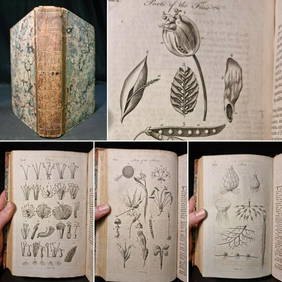
1797 Universal Magazine BOTANY PLATES Flowers FRUIT 12 Copper Engraved PlatesPrivate NY Collection4.2(22)See Sold PriceMar 01, 2024
Arrowsmith & Lewis - Map of PolynesiaTrillium Antique Prints & Rare Books4.5(32)See Sold PriceFeb 24, 2024
Arrowsmith & Lewis - Map of North AmericaTrillium Antique Prints & Rare Books4.5(32)See Sold PriceFeb 24, 2024
Arrowsmith & Lewis - Map of the World on Mercator's ProjectionTrillium Antique Prints & Rare Books4.5(32)See Sold PriceFeb 24, 2024
Arrowsmith & Lewis - Map of LouisianaTrillium Antique Prints & Rare Books4.5(32)See Sold PriceFeb 24, 2024
Arrowsmith & Lewis - Map of the United StatesTrillium Antique Prints & Rare Books4.5(32)See Sold PriceFeb 24, 2024
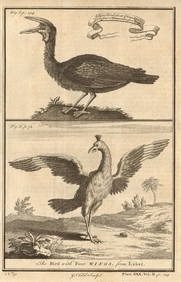
Gambian birds. Monoceros. A bird with four wings. CHILD 1745 old antique printJasper524.5(9.9k)See Sold PriceFeb 28, 2024