ATLAS of ANTIENT GEOGRAPHY by SAMUEL BUTLER 1843John McInnis Auctioneers,LLC4.5(505)See Sold PriceFeb 24, 2024
18TH C. ANTIQUE MAP: FRENCH & INDIAN WAR, FRAMEDThomaston Place Auction Galleries4.4(393)See Sold PriceFeb 24, 2024
Rand McNally Railroad Map Cabinet w/ 21 Railroad MapsRail & Road Auctions4.6(165)See Sold PriceMar 08, 2024
Keith Haring - Ink on New York Map, Best Buddies, Inscribed, Signed, and DatedSapphire Auction Gallery4(67)See Sold PriceMar 02, 2024
LATE 17TH C. FRENCH MAP OF THE NEW WORLD BY ALEXIS-HUBERT JAILLOT (1632-1712)Thomaston Place Auction Galleries4.4(393)See Sold PriceFeb 24, 2024
Central Railroad of New Jersey Map of Sandy Hook Route-ca. 1903JM Hobby Supply and Railroad Artifact Auctions4.4(127)See Sold PriceFeb 24, 2024
Lot of Six Mixed Atlas Box Cars-HO Scale-New in BoxJM Hobby Supply and Railroad Artifact Auctions4.4(127)See Sold PriceFeb 25, 2024
Rand McNally/Santa Fe Railroad Map of Iowa-1912JM Hobby Supply and Railroad Artifact Auctions4.4(127)See Sold PriceFeb 24, 2024
NICOLAES VISSCHER (NETHERLANDS, 1618-1709) MAP OF THE NEW WORLDThomaston Place Auction Galleries4.4(393)See Sold PriceFeb 24, 2024
17TH C. WORLD MAP BY NICOLAES VISSCHER (NETHERLANDS, 1618-1709)Thomaston Place Auction Galleries4.4(393)See Sold PriceFeb 24, 2024
Lot of Six Mixed Atlas Cabooses-HO Scale-New in BoxJM Hobby Supply and Railroad Artifact Auctions4.4(127)See Sold PriceFeb 25, 2024
SoldColton: Antique Map, Sizes of Lakes and Islands, 1859Title/Content of Map: Sizes of Lakes and Islands by Colton Date Printed: 1859 Cartographer: H.J. Colton Material/Medium: Paper Size: 17 1/2" x 15" Hand colored steel engraved Map. From 'Colton's GenerSee Sold Price
1855 Colton View of Lakes and Islands Globally --Title/Content of Map: 1855 Colton View of Lakes and Islands Globally -- Comparative Size Lakes, Islands Date: 1855, New York Cartographer: J Colton Size: 11.7 X 14.6 in. This is a great thematic map tSee Sold Price
1855 Colton View of Lakes and Islands Globally --Title/Content of Map: 1855 Colton View of Lakes and Islands Globally -- Comparative Size Lakes, Islands Cartographer: J Colton Year/Place: 1855, New York Size: 11.7 X 14.6 in. This is a great thematicSee Sold Price
1855 Colton View of Lakes and Islands Globally --Title/Content of Map: 1855 Colton View of Lakes and Islands Globally -- Comparative Size Lakes, Islands Cartographer: J Colton Year/Place: 1855, New York Size: 11.7 X 14.6 in. This is a great thematicSee Sold Price
1855 Colton View of Lakes and Islands Globally --Title/Content of Map: 1855 Colton View of Lakes and Islands Globally -- Comparative Size Lakes, Islands Cartographer: J ColtonDate: 1855, New York Size: 11.7 X 14.6 in. This is a great thematic map thSee Sold Price
1855 Colton View of Lakes and Islands Globally --Title: 1855 Colton View of Lakes and Islands Globally -- Comparative Size Lakes, Islands Date: 1855, New York Cartographer: J Colton Size: 11.7 X 14.6 in. Additional Information: This is a great themaSee Sold Price
1855 Colton View of Lakes and Islands Globally --Title: 1855 Colton View of Lakes and Islands Globally -- Comparative Size Lakes, Islands Date: 1855, New York Cartographer: J Colton Size: 11.7 X 14.6 in. Additional Information: This is a great themaSee Sold Price
Sold1859 Worlds lakes and islands size comparison by ColtonTitle: 1859 Worlds lakes and islands size comparison by Colton Date/Period: 1859 Materials: Hand colored steering engraved Size: 17 1/2 x 14 1/2” An interesting chart shows the sizes of the worlSee Sold Price
Sold1855 Colton View of Lakes and Islands Globally --Title: 1855 Colton View of Lakes and Islands Globally -- Comparative Size Lakes, Islands Cartographer: J Colton Year / Place: 1855, New York Map Dimension (in.): 11.7 X 14.6 in. This is a great thematSee Sold Price
SoldColton: Antique Map of Lakes and Islands, 1861Title/Content of Map: Lakes and Islands Date Printed: 1861 Cartographer: J. H. Colton Material/Medium: Paper Size: 17 1/4" X 13" Condition: Excellent Hand colored, steel engraved. From 'Colton's GenerSee Sold Price
G.W. COLTON - COMPARATIVE SIZE OF LAKES AND ISLANDS,G.w. Colton - Comparative Size Of Lakes And Islands, 1856 - 36 X 29 3/4 In. - This Giclée Print Is Gallery Stretched And Ready To Hang Or Lean Against A Wall, Or Display On An Easel. - A Giclée PrinSee Sold Price
G.W. COLTON - COMPARATIVE SIZE OF LAKES AND ISLANDS,G.w. Colton - Comparative Size Of Lakes And Islands, 1856 - 36 X 29 3/4 In. - Giclée Print - Gallery Stretched - Ready to hang.See Sold Price
G.W. COLTON - COMPARATIVE SIZE OF LAKES AND ISLANDS,G.w. Colton - Comparative Size Of Lakes And Islands, 1856 - 36 X 29 3/4 In. - Giclée Print - Gallery Stretched - Ready to hang.See Sold Price
G.W. COLTON - COMPARATIVE SIZE OF LAKES AND ISLANDS,G.w. Colton - Comparative Size Of Lakes And Islands, 1856 - 36 X 29 3/4 In. - This Giclée Print Is Gallery Stretched And Ready To Hang Or Lean Against A Wall, Or Display On An Easel. - A Giclée PrinSee Sold Price
G.W. COLTON - COMPARATIVE SIZE OF LAKES AND ISLANDS,G.w. Colton - Comparative Size Of Lakes And Islands, 1856 - 36 X 29 3/4 In. - This Giclée Print Is Gallery Stretched And Ready To Hang Or Lean Against A Wall, Or Display On An Easel. - A Giclée PrinSee Sold Price
G.W. COLTON - COMPARATIVE SIZE OF LAKES AND ISLANDS,G.w. Colton - Comparative Size Of Lakes And Islands, 1856 - 30 X 24 3/4 In. - This Giclée Print Is Gallery Stretched And Ready To Hang Or Lean Against A Wall, Or Display On An Easel. - A Giclée PrinSee Sold Price
G.W. COLTON - COMPARATIVE SIZE OF LAKES AND ISLANDS,G.W. COLTON - COMPARATIVE SIZE OF LAKES AND ISLANDS, 1856 - 36 x 29 3/4 in. - Museum Wrapped The Piece Of Art Is Ready To Hang Or Lean Against A Wall, Or Display On An Easel. - A Giclée Print Is TheSee Sold Price
G.W. COLTON - COMPARATIVE SIZE OF LAKES AND ISLANDS,G.W. COLTON - COMPARATIVE SIZE OF LAKES AND ISLANDS, 1856 - Giclée on Canvas 36 x 29 3/4 in. - A Giclée Print Is The Highest Quality Print Available Today. Because There Is No Visible Dot Screen PatSee Sold Price
COMPARATIVE SIZE OF LAKES AND ISLANDS, 1856"G.W. COLTON"COMPARATIVE SIZE OF LAKES AND ISLANDS, 1856"36 x 29 3/4 in. This Giclée is high-resolution and of the highest quality, has a color permanence rating in excess of 100 years. Printed on CanSee Sold Price
G.W. COLTON "COMPARATIVE SIZE OF LAKES AND ISLANG.W. COLTON"COMPARATIVE SIZE OF LAKES AND ISLANDS, 1856"30 x 24 3/4 in. This Giclée is high-resolution and of the highest quality, has a color permanence rating in excess of 100 years. Printed on CanSee Sold Price
19thc Colton Map of New Brunswick, Nova Scotia,1857 Colton Map of New Brunswick, Nova Scotia, Newfoundland & Prince Edward Island. Antique geographical map. From the famous "Colton's General atlas" by Colton ( NYC J.H. Colton And Company, No. 172See Sold Price
SoldTwo (2) Circa 1871 Litho Maps of North AmericaTwo (2) identical maps, circa 1871 lithographs of North America, with reverse showing comparative sizes of lakes and islands in eastern and western hemispheres, published by Gray, sheet size 17 1/4" xSee Sold Price
SoldTwo (2) Circa 1871 Litho Maps of North AmericaTwo (2) identical maps, circa 1871 lithographs of North America, with reverse showing comparative sizes of lakes and islands in eastern and western hemispheres, published by Gray, sheet size 17 1/4" xSee Sold Price
SoldHand Painted Colton Map of New York GeographicusThis lot features a hand painted Colton Map of New York. This is the uncommon 1857 issue of J. H. Colton’s map of New York. Covers the entire state including Lake Ontario, Long Island, and detailedSee Sold Price
Rock Island RR Iowa and Minnesota Lakes Country Brochure-1926JM Hobby Supply and Railroad Artifact Auctions4.4(127)See Sold PriceFeb 24, 2024
LATE 17TH C. FRENCH MAP OF THE NEW WORLD BY ALEXIS-HUBERT JAILLOT (1632-1712)Thomaston Place Auction Galleries4.4(393)See Sold PriceFeb 24, 2024
19thc Colton Map, Comparitive Size of Lakes & IslandsConnoisseur Auctions3.9(336)See Sold PriceFeb 24, 2024
1853 Colton's Railroad & Township Map of Massachusetts, Rhode Island, and ConnecticutRail & Road Auctions4.6(165)See Sold PriceMar 07, 2024
Oyster Bay Long Island NY Vintage Color Reproduction Map 12 x 18Mynt Auctions4.6(697)See Sold PriceFeb 23, 2024
1822 MAP of LEEWARD ISLANDS GEOGRAPHICAL STATISTICAL HISTORICAL antique 17.5x22"Jasper524.5(9.9k)See Sold PriceFeb 27, 2024
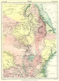
NILE VALLEY. Sudan Tanzania Ethiopia Uganda Lake Victoria. Britannica. 1898 mapJasper524.5(9.9k)See Sold PriceFeb 28, 2024
West Africa. Liberia Sahara Senegambia Guinea. Mountains of Kong COLTON 1869 mapJasper524.5(9.9k)See Sold PriceFeb 28, 2024
North west Africa. Liberia inset. Sahara Senegambia Guinea. COLTON 1863 mapJasper524.5(9.9k)See Sold PriceFeb 28, 2024
Coste Occidentale d’Afrique…' West Africa. Gulf of Guinea. BELLIN 1746 mapJasper524.5(9.9k)See Sold PriceFeb 28, 2024
NIGERIA explorers' routes. Lander Clapperton Oudney Denham Allen. SDUK 1874 mapJasper524.5(9.9k)See Sold PriceFeb 28, 2024
French West Africa. Gold Coast. Sahara desert sand dunes. TIMES 1956 mapJasper524.5(9.9k)See Sold PriceFeb 28, 2024
Churchill & Nieuhof 1744 Map. Batavia Jakarta IndonesiaAlbion Auctions4.6(341)See Sold PriceMar 01, 2024
Rare 19thc Colton Map, Argentine Republic, Chile, Uruguay, PataguayConnoisseur Auctions3.9(336)See Sold PriceMar 16, 2024
James Cook - Map of the Friendly Isles - Tonga IslandsProverde Auctions4.3(3)See Sold PriceFeb 28, 2024
Jacques Nicolas Bellin - Antique Map - Vue de la Rade de Tiniam, double antique coast view of theProverde Auctions4.3(3)See Sold PriceFeb 28, 2024
Robert de Vaugondy - Map of Canada - Mer de l' Ouest or Sea of the West and a Northwest PassageProverde Auctions4.3(3)See Sold PriceFeb 28, 2024