ATLAS of ANTIENT GEOGRAPHY by SAMUEL BUTLER 1843John McInnis Auctioneers,LLC4.5(494)See Sold PriceFeb 24, 2024
18TH C. ANTIQUE MAP: FRENCH & INDIAN WAR, FRAMEDThomaston Place Auction Galleries4.4(386)See Sold PriceFeb 24, 2024
Rand McNally Railroad Map Cabinet w/ 21 Railroad MapsRail & Road Auctions4.6(165)See Sold PriceMar 08, 2024
Keith Haring - Ink on New York Map, Best Buddies, Inscribed, Signed, and DatedSapphire Auction Gallery3.9(67)See Sold PriceMar 02, 2024
LATE 17TH C. FRENCH MAP OF THE NEW WORLD BY ALEXIS-HUBERT JAILLOT (1632-1712)Thomaston Place Auction Galleries4.4(386)See Sold PriceFeb 24, 2024
Central Railroad of New Jersey Map of Sandy Hook Route-ca. 1903JM Hobby Supply and Railroad Artifact Auctions4.4(126)See Sold PriceFeb 24, 2024
Lot of Six Mixed Atlas Box Cars-HO Scale-New in BoxJM Hobby Supply and Railroad Artifact Auctions4.4(126)See Sold PriceFeb 25, 2024
Rand McNally/Santa Fe Railroad Map of Iowa-1912JM Hobby Supply and Railroad Artifact Auctions4.4(126)See Sold PriceFeb 24, 2024
NICOLAES VISSCHER (NETHERLANDS, 1618-1709) MAP OF THE NEW WORLDThomaston Place Auction Galleries4.4(386)See Sold PriceFeb 24, 2024
Lot of Six Mixed Atlas Cabooses-HO Scale-New in BoxJM Hobby Supply and Railroad Artifact Auctions4.4(126)See Sold PriceFeb 25, 2024
Visscher's Map of Souther GreecePeloponnesus hodie Morea...Nicolaes Visscher (1618-1709). Engraved map with original hand color. Amsterdam, c.1680. 21 1/4 x 25 1/4 inches sheet. Attractive map of the Morea, scene of fighting betweenSee Sold Price
SoldMap of Martinique, Nicolaes Visscher (Dutch, 1618)[Antique Map of Martinique], "Insula Matanino vulgo Martanico", by Nicolaes Visscher (Dutch, 1618-1709), hand-colored copper engraving, c. 1680, Amsterdam, featuring decorative cartouche and two compaSee Sold Price
SoldNovi Belgii Novaeque Angliae"Novi Belgii Novaeque Angliae nec non Partis Virginiae Tabula" early New England map after Nicolaes Visscher (Dutch, 1618-1709), color facsimile printed on wove paper, ca. 1900, watermarked "Van GeldeSee Sold Price
SoldNovi Belgii Novaeque Angliae Map after Visscher"Novi Belgii Novaeque Angliae nec non Partis Virginiae Tabula" early New England map after Nicolaes Visscher (Dutch, 1618-1709), color facsimile printed on wove paper, ca. 1900, watermarked "Van GeldeSee Sold Price
Double hemisphere world map by Jan van Jagen 1741After “Orbis Terrarum Tabula Recens Emendata et in Lucem Edita per N. Visscher” world map by Nicholas Visscher (The Netherlands, 1618-1679), published in a Dutch Bible, 1663. Double hemispSee Sold Price
Sold17th C. Map of New Netherlands - Nicholas Visscher"Novi Belgii Novaeque Angliae Nec Non partis Virginiae Tabula"--1656, hand colored engraved map, second state. Antique map depicting early view of America (or New Netherlands) with one of the first deSee Sold Price
Nicolaes Visscher, Map of the World, 17th Century'Orbis Terrarum Tabula Recens Emendata et in Lucem Edita', 17th century map. Dutch bible double-hemisphere world map with allegorical figure scenes of Europe, Asia, Africa and America in the 4 cornersSee Sold Price
Soldmap, Nicolaes Visscher, Terra SanctaFramed handcolored copper engraved map, Terra Sancta, 1659, Antique map of the Holy Land, by Nicolaes Visscher (Dutch, 1618-1709), sight: 18.25''h x 22.25''w, overall: 23.25''h x 27.125''wSee Sold Price
Soldmap, Nicolaes Visscher, Terra SanctaFramed handcolored copper engraved map, Terra Sancta, 1659, Antique map of the Holy Land, by Nicolaes Visscher (Dutch, 1618-1709), sight: 18.25''h x 22.25''w, overall: 23.25''h x 27.125''wSee Sold Price
Sold17TH C. MAP OF AMERICAS NICOLAUM VISSCHER(1618-1679):17th century map of Americas by Nicolaum Visscher. Also known as: Nicolaes Visscher Among the many great Dutch map publishers active in the seventeenth century were the Visscher family, begun by ClaesSee Sold Price
Map, Nicolaes VisscherNicolaes Visscher (Dutch, 1618-1709), "Exactissima Platinatus Rheni ac Ducatus Bipontini Tabula," circa 1688, hand colored engraving, image (sight): 18"h x 22.25"w, overall (with frame): 25.25"h x 29.See Sold Price
SoldMap, Nicolaes VisscherNicolaes Visscher (Dutch, 1618-1709), "Exactissima Platinatus Rheni ac Ducatus Bipontini Tabula," circa 1688, hand colored engraving, image (sight): 18"h x 22.25"w, overall (with frame): 25.25"h x 29.See Sold Price
Map, Nicolaes VisscherNicolaes Visscher (Dutch, 1618-1709), "Exactissima Platinatus Rheni ac Ducatus Bipontini Tabula," circa 1688, hand colored engraving, image (sight): 18"h x 22.25"w, overall (with frame): 25.25"h x 29.See Sold Price
SoldNicolaes Visscher World Map 1657Nicolaes Visscher I (1618-1679), "Orbis Terrarum Typus de Integro in Plurimis Emendatus, Auctus, et Icunculis Illustratus," Amsterdam, 1657. Highly detailed world map in two hemispheres. ThrSee Sold Price
SoldNicolaes Visscher World Map 1657Nicolaes Visscher I (1618-1679), "Orbis Terrarum Typus de Integro in Plurimis Emendatus, Auctus, et Icunculis Illustratus," Amsterdam, 1657. Highly detailed world map in two hemispheres. Three celestiSee Sold Price
Sold17th - 18th century Dutch map. Transisalania17th - 18th century Dutch map. Transisalania Over-IJssel by Nicolaum Visscher. 1618 - 1709. Hand colored. Engraving on paper. Dimensions: H 51 x W 59 cm. In good condition.See Sold Price
A New Mapp of the Kingdome of England. c.1690.[England & Wales] Visscher, Nicolaes (Dutch, 1618-1709). "A New Mapp of the Kingdome of England, Representing the Princedome of Wales, and other Provinces, Cities, Market Towns, with the Roads from ToSee Sold Price
SoldA New Mapp of the Kingdome of England. c.1690.[Great Britain] Visscher, Nicolaes (Dutch, 1618-1709). "A New Mapp of the Kingdome of England, Representing the Princedome of Wales, and other Provinces, Cities, Market Towns, with the Roads from TownSee Sold Price
Visscher Double Hemisphere MapOrbis Terrarum Tabula Recens... Nicholas Visscher (1618-1709). Engraved map with original hand color. Amsterdam, c. 1663 (State 2, 1677). 12 1/2 x 19 1/4 inches visible, 24 x 30 1/2 inches framed. ThiSee Sold Price
SoldNicolaes Visscher I, Dutch 1618-1679- ''Paradise or theNicolaes Visscher I, Dutch 1618-1679- ''Paradise or the Garden of Eden'', from the Royal-Size Bible, publ by Nicolaes and Claes Jansz Visscher, Amsterdam, c.1652; engraved map on laid, with centrefoldSee Sold Price
Sold17TH C MAP OF NEW NETHERLANDS - Novi Belgii Novaeque17TH C MAP OF NEW NETHERLANDS - Novi Belgii Novaeque Angliae: nec non partis Virginiae tabula multis in locis emendata. Amsterdam. Andreas Visscher, 1656. Engraving on laid paper, later hand coloring.See Sold Price
SoldMiddle East Antique Dutch MapNicolaes Visscher (1618-1679). De Gelegentheyt Van't Paradys Ende 'T Landt Canaan. Amsterdam, c. 1650. Hand-colored engraving. Holy Land, Israel, Palestine. 16 1/2" x 20 1/2".See Sold Price
Sold3 maps of the Netherlands. 1685-1748.[Netherlands] 3 maps. (1) Visscher II, Nicolaes. “Brabantiae Batavae Pars Orientalis.” Amsterdam, c.1685. Engraved map. 23 1/8” x 20”. (2) Homann Heirs. “Belgii UniversiSee Sold Price
Visscher Map of Asia*** START PRICE IS THE RESERVE *** [Asia] VISSCHER, Nicholas (1618-1709). Asiae Nova Delineatio. Engraved map with original hand color in part. Amsterdam, c. 1690. 19 1/4" x 19 3/8" sheet. Comparable:See Sold Price
17TH C. ENGLISH CIVIL WAR HISTORY PAINTINGThomaston Place Auction Galleries4.4(386)See Sold PriceFeb 24, 2024
LARGE LATE 17TH C. DUTCH CHART OF CANADA, GREAT LAKES, NEW FRANCE, LABRADOR, HUDSON BAY, BY PIERREThomaston Place Auction Galleries4.4(386)See Sold PriceFeb 24, 2024
17TH C. WORLD MAP BY NICOLAES VISSCHER (NETHERLANDS, 1618-1709)Thomaston Place Auction Galleries4.4(386)See Sold PriceFeb 24, 2024
LATE 17TH C. FRENCH MAP OF THE NEW WORLD BY ALEXIS-HUBERT JAILLOT (1632-1712)Thomaston Place Auction Galleries4.4(386)See Sold PriceFeb 24, 2024
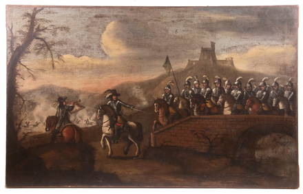
17TH C. ANTIQUE MAP SIEGE OF LA ROCHELLE, FRANCE, FRAMEDThomaston Place Auction Galleries4.4(386)See Sold PriceFeb 24, 2024
17TH C. MAP OF THE BERKSHIRES BY JOHN SPEED, FRAMEDThomaston Place Auction Galleries4.4(386)See Sold PriceFeb 24, 2024
17TH C. ENGLISH LINEAR MAP BY OGILBY, FRAMEDThomaston Place Auction Galleries4.4(386)See Sold PriceFeb 24, 2024
NICOLAES VISSCHER (NETHERLANDS, 1618-1709) MAP OF THE NEW WORLDThomaston Place Auction Galleries4.4(386)See Sold PriceFeb 24, 2024
Antique 17th C English Geometric Oak Chest of DrawersKavanagh Auctions4.6(287)See Sold PriceFeb 24, 2024
Willem Blaeu, Etc. 17th C. Antiquarian Maps, 2Auctions at Showplace4.5(723)See Sold PriceMar 17, 2024
3 Vintage The World Lithographs, By JanssonThe Benefit Shop Foundation Inc.4.3(2.9k)See Sold PriceMar 13, 2024
Three boxed 1:72 scale limited edition die-cast models of WWII RAF Avro Lancaster and Short Stir...Bonhams4.1(299)See Sold PriceMar 01, 2024
Framed Vintage Style Visscher Commander Repro MapRapid Estate Liquidators and Auction Gallery4.5(1.1k)See Sold PriceMar 01, 2024