SoldFOUR MAPS OF CERONS, BOURGEAIS, POMEROL, GRAVESFrom 'Atlas de la France Vinicole, les Vins de Bordeaux.' Includes a map of 'Lalande de Pomerol,' matted, 10.25 x 7 inch sight size; 'Boureais,' 10.5 x 8.5 inches; double map of 'Cerons, Loupiac, St CSee Sold Price
SoldFOUR MAPS OF BORDEAUX, FRONSAC, POMEROL, ST EMILIONFrom 'Atlas de la France Vinicole, les Vins de Bordeaux.' Includes a map of 'Cotes Canon-Fronsac, Cotes de Fronsac,' matted, 10.5 x 8.5 inch sight size; 'Pomerol,' 8 x 8 inches; double map of Cotes deSee Sold Price
SoldLarmat: Bordeaux Vins Wine Map, 1944Title/Content of Map: ' "Les Vins de Bordeaux" - Graves - Graves Supérieures - Cérons'. Date Printed: 1944. Image Size: Approx 64.0 x 45.0cm, 25.25 x 17.75 inches (Large); Please note that this is aSee Sold Price
SoldMatted, framed map of Derbyshire, England, with aMatted, framed map of Derbyshire, England, with a crest on top and inset photos of: Matlock in 1790, All Saints Derby, Entrance to the Peak Cavern (with four grave markers), and Chatsworth House, prinSee Sold Price
Sold1850 McDowall Diamond Maps ATLAS Geography England1850 McDowall Diamond Maps ATLAS Geography England Scotland Ireland World Color A collection of 19th-century McDowall maps. These four maps are extremely desirable, hand-colored views. Maps include: �See Sold Price
SoldGrp: 4 Maps of Eastern Europe Romanian TransylvanGroup of four maps of Eastern Europe. One map by Gerard Valck and Peter Schenk depicting Serbia, Bulgaria, and Romania; one map by Gerard and Leonard Valck depicting Wallachia, Transylvania, and MoldoSee Sold Price
SoldFour Antique MapsFour antique maps. Including a very early hand made paper map of Florida and Virginia. Fragment of old newspaper on back dated 1630. Unframed, each approx H 21" W 24". All in excellent condition, minoSee Sold Price
SoldNancy Graves - Four Times FourLot 64 Nancy Graves - Four Times Four American (1940-1995) Four Times Four (1981) silkscreen signed lower right, numbered 33/45 plate: 14 1/2 x 14 1/2 inches frame: 26 1/4 x 26 1/2 inches Provenance:fSee Sold Price
SoldFour Antique Continental MapsFour Antique Continental Maps , 17th to 19th c., incl. map of Ireland, British Colonies, Virginia, and two bird's-eye-views, largest 18 3/4 in. x 26 in Provenance: Property deaccessioned from the LouiSee Sold Price
SoldA Group of Four Hand-colored Engraved Maps, 19th/20thA Group of Four Hand-colored Engraved Maps, 19th/20th Century, Including three maps by Gerardus Mercator depicting Austria Archiducatus, Saltzburg and Flanders, and one map by Frederick de Wit depictiSee Sold Price
SoldFour Books of Maps and Tourist GuidesA lot of four books, including "Mitchell's New Primary Geography" (1876); "Dickens's Dictionary of London" (1880); "Kobe's Jersey Coast and Pines"; and "The Stranger in Philadelphia".See Sold Price
SoldFour 18th c. US Maps, Mainly SouthernFour (4) 18th c. maps of southern United States. 1st item: Abraham Bradley Jr. "Map of the Southern Part of the UNITED STATES OF AMERICA" drawn and engraved for Morse's American Gazetteer. Boston, 179See Sold Price
SoldLinda Graves. Three Acrylic/Paper AbstractsLinda Graves (American, Contemporary). Four acrylic on arches paper abstract paintings from The Walton Series. All signed and unframed. Each sheet measures 26 in x 26 in.See Sold Price
SoldPlan Of New Haven Connecticut Amos Doolittle 1824Plan of the city of New Haven Connecticut by Amos Doolittle, dated 1824. Surveyed and published by Doolittle.This item has been inspected out of the Frame. The Map is in four individual pieces, laid tSee Sold Price
SoldSCARCE GERMAN SCHUCO WIND-UP MR. WORLD FIGURE.Tough to find original box marked "967". Figure is of a character with a tin-litho world map head and four plastic satellites spinning around in front of his chest when wound. CONDITION: Has originalSee Sold Price
Sold1748 1ed ROME Nero Four Emperors Otho Vespasian1748 1ed ROME Nero Four Emperors Otho Vespasian Claudius MAPS Universal History The “Universal History” is a mid-18th-century history of the world. Written by numerous authors and contributors, thSee Sold Price
SoldGrp: 13 Maps of Italy and from Munster's CosmograGroup of 17th-19th century maps. This lot includes four pages from Sebastian Munster's "Cosmographia" including a map of Elba, a map of Italian mainland cities, a map of Sicily, and a map of Africa. TSee Sold Price
Sold1873 Adirondack Survey Map -5 Pond Wilderness Areaby Verplanck Colvin. Showing the approximate positions and names of 39 ponds or lakes. Mountains to include: Cat mountain, Wolf Mountain, Deer Mountain, Graves Mountain. Nicely Framed. This map showsSee Sold Price
SoldCollection of 4 Bottles of Wine2001 Chateau Clerc Milon 1.5 Liters, 1986 Chateau Gruaud Larose 1.5 Liters, Chateau Haut Brion 1976 Graves 2.98 Liters, 1981 Petrus Pomerol 1.5 LitersSee Sold Price
SoldAFRICA and ABOLITIONISM.Four 19th-century books and a 1940 map of African, as follows: Thatcher, B.B. Memoir of Rev. S. Osgood Wright, late Missionary to Liberia (Boston: Light and Horton, 1834), 12mo, 126 pp., back endpaperSee Sold Price
SoldManoil Communications Military FiguresManoil Communications Military figures including; map reader, wireless operator, pigeon handler, four field telephones, and three lineman with one telephone pole. Figures range in condition from likeSee Sold Price
Sold1866 MAPS Atlas Appleton Companion Travel Handbook1866 MAPS Atlas Appleton Companion Travel Handbook Geography United States Color A rare and finely illustrated atlas companion by Richards and Appleton. This Civil War-era work features four enormousSee Sold Price
Sold1866 1ed Civil War Four Years of Fighting Coffin1866 1ed Civil War Four Years of Fighting Coffin Guerilla Warfare Music MAPS Charles Carleton Coffin was one of the best-known newspaper correspondents of the Civil War. His book ‘Four Years of FighSee Sold Price
SoldNancy Graves (American 1940-1995) Lithograph"Geologic Maps of Lunar Orbitor and Apollo Landing II, " 1972, lithograph, published by Landfall Press, Chicago, IL, signed in pencil and dated, lower right, inscribed and numbered II A/P/2 in pSee Sold Price
Southern Pacific RR Four Gateways to the Pacific Coast Brochure-1917JM Hobby Supply and Railroad Artifact Auctions4.4(126)See Sold PriceFeb 24, 2024
Chicago Burlington and Quincy RR July 5, 1894 Public TimetableJM Hobby Supply and Railroad Artifact Auctions4.4(126)See Sold PriceFeb 24, 2024
New York Central and Hudson River RR Public Timetable-November 3, 1901JM Hobby Supply and Railroad Artifact Auctions4.4(126)See Sold PriceFeb 24, 2024
18 Booklets Collection - War Graves of Palestine - WWILevy Auction House4.3(11)See Sold PriceFeb 27, 2024
Ancient Roman Republican Coins - Roman Republican - AES Grave Victorian CopyTimeLine Auctions Ltd.4.5(183)See Sold PriceMar 09, 2024
Large Assortment of Railroad Items - Insulators, Globes, Hand Bell, Posters, Maps, Timetables,Rail & Road Auctions4.6(165)See Sold PriceMar 07, 2024
1855 Map of New York & Erie Railroad and 1917 Trespassing On Railway Property Is A MisdemeanorRail & Road Auctions4.6(165)See Sold PriceMar 07, 2024
Eight Gulf, Mobile & Ohio Railroad Playing Card Decks - Alton Route Map and LogoRail & Road Auctions4.6(165)See Sold PriceMar 08, 2024
Four White Pass & Yukon Route Playing Card DecksRail & Road Auctions4.6(165)See Sold PriceMar 08, 2024
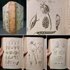
1797 Universal Magazine BOTANY PLATES Flowers FRUIT 12 Copper Engraved PlatesPrivate NY Collection4.2(21)See Sold PriceMar 01, 2024
Arrowsmith & Lewis - Map of North AmericaTrillium Antique Prints & Rare Books4.5(30)See Sold PriceFeb 24, 2024
Arrowsmith & Lewis - Map of the World on Mercator's ProjectionTrillium Antique Prints & Rare Books4.5(30)See Sold PriceFeb 24, 2024
Arrowsmith & Lewis - Map of LouisianaTrillium Antique Prints & Rare Books4.5(30)See Sold PriceFeb 24, 2024
Arrowsmith & Lewis - Map of the United StatesTrillium Antique Prints & Rare Books4.5(30)See Sold PriceFeb 24, 2024