Timetable, Paper and Ephemera Lot-Eastern USA RailroadsJM Hobby Supply and Railroad Artifact Auctions4.4(126)See Sold PriceFeb 24, 2024
[BASEBALL]. Group of Varied Ephemera, including: Sporting L...Potter & Potter Auctions4.6(539)See Sold PriceMar 07, 2024
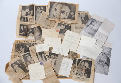
EPHEMERA from the MARRIAGE of MS. EUNICE KENNEDYJohn McInnis Auctioneers,LLC4.6(502)See Sold PriceFeb 25, 2024
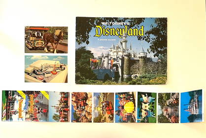
Rare Lot of 1965 and 1977 Walt Disneyland Collectible EphemeraSouth Florida Auction & Estate Sale Services Inc4.5(520)See Sold PriceMar 08, 2024
[CIGARETTE CARDS AND TOBACCO EPHEMERA]. A Group of Six Coll...Potter & Potter Auctions4.6(539)See Sold PriceMar 07, 2024
Group of MLB Ticket and Passes, Other Ephemera: American League Annual PassDana J. Tharp Auctions4.7(268)See Sold PriceFeb 24, 2024
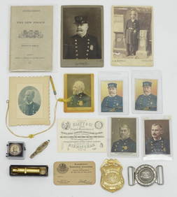
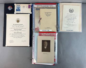
Group of US Presidents inauguration souvenirs, and EphemeraMatthew Bullock Auctioneers4.7(1.8k)See Sold PriceFeb 24, 2024
Sold1758 Gentlemans Magazine with Maps of EuropeMaps“Old Map of the Continent" & other Maps December 1758, THE GENTLEMAN’S MAGAZINE, London, England, Choice Extremely Fine. 8” x 5,” 2-column layout, pp. 559-614. By SylvanusSee Sold Price
SoldGentleman’s Magazine Map of the New Continent, 1758Map: A Map of the New Continent according to its greatest diametrical Length from the River la Plata to beyond the Lake of the Assiniboits Maker: Gentleman's Magazine Place & Date: London / 1758 Size:See Sold Price
DEC 1758 GENTLEMAN'S MAGAZINE by S URBAN LONDON ANTIQUEDEC 1758 GENTLEMAN'S MAGAZINE by S URBAN LONDON ANTIQUE NEWSPAPER w MAPS AMERICA DEC 1758 GENTLEMAN'S MAGAZINE by S URBAN LONDON ANTIQUE NEWSPAPER w MAPS AMERICA Description EARLY ANTIQUE NEWSPAPER; "See Sold Price
Sold4 Framed Antique Maps, 1758, Jacques-Nicolas Bellin:4 Framed Antique Maps, 1758, Jacques-Nicolas Bellin: Bellin (1703-1772) was 18 Years old when Appointed Chief Cartographer for French Navy. Four Maps from the "Le petit Atlas Francois Recueil de CarteSee Sold Price
Sold1764 Four Maps Sixteen Miles Round London1764 Four-Map set of "An Accurate Map of the Country Sixteen Miles round London Drawn and Engrav’d from an Actual Survey". The maps represent the four section of the total map and were printed for GSee Sold Price
1787 Four Maps Counties of Walers GroseFour maps of the counties of Wales engraved at the top portion of four leaves with text related to the area. Printed in 1787 for Francis Grose based on John Sellers map of 1695. Each in Fine conditionSee Sold Price
Sold1850 McDowall Diamond Maps ATLAS Geography England1850 McDowall Diamond Maps ATLAS Geography England Scotland Ireland World Color A collection of 19th-century McDowall maps. These four maps are extremely desirable, hand-colored views. Maps include: �See Sold Price
Sold1787 FOUR Grose Maps of WalesFour maps of the counties of Wales engraved at the top portion of four leaves with text related to the area. Printed in 1787 for Francis Grose based on John Sellers map of 1695. Each in Fine conditionSee Sold Price
Mine Related Maps, Alaska, c 1900-1910 (112192)Four maps from the files of engineer J.L. McPherson. Blueline of Wrangell recording District, 1911, about 12 x 18"; black ink on linen map of the Tombstone Lode, 1911, about 10 x 14", probably at NomeSee Sold Price
Sold3 BOOKS, OLD MAPS AND A HISTORY OF CARTOGRAPHY2 hardcovers of history told through maps and cartography. The seventy-four maps which have been reproduced in this unique collection were selected from libraries all over Europe and America. The wealSee Sold Price
1758 Gentlemans Magazine, London"Old Map of the Continent" & other Maps December 1758, THE GENTLEMAN'S MAGAZINE, London, England, Choice Extremely Fine. 8" x 5," 2-column layout, pp. 559-614. By Sylvanus Urban, "Printed by D. HenrySee Sold Price
1758 London Magazine Plan of Dunkirk, France -- A PlanTitle: 1758 London Magazine Plan of Dunkirk, France -- A Plan of DUNKIRK with the New Works made since the Treaty of Utrecht 1714 Cartographer: London Magazine Year / Place: 1758, London Map DimensionSee Sold Price
Scots Magazine (1758)Sand, Donaldson, Murray & Cochran Edinburgh 1sr Edition Full year including appendix 708 pages plus index. Volume 20 6 maps, plans & engravings. Lacking maps of Europe & Scotland. & pages 181-196.. .NSee Sold Price
1758 London Magazine Plan of Dunkirk, France -- A PlanTitle: 1758 London Magazine Plan of Dunkirk, France -- A Plan of DUNKIRK with the New Works made since the Treaty of Utrecht 1714 Cartographer: London Magazine Year / Place: 1758, London Map DimensionSee Sold Price
Explorations in Bible Lands, 1st ed.Explorations in Bible Lands During the 19th Century by H. V. Hilprecht. Includes four loose maps inserted into cover flaps and nearly 200 illustrations. Maps: Large map of Western Asia, Plan of BabyloSee Sold Price
SoldGold Dredging in California, 1905, Extra Rare!By state mineralogist Lewis E. Aubrey. 70 illustrations. 120 pages. Four delicate maps and graph foldouts in front and back. Excellent condition.Date: 1905Country (if not USA): State: CaliforniaCity:See Sold Price
[Vigilyansky, P.] «The Experience Of Sacred Geography»St. Petersburg, 1808. - [4], VIII, 84 pp., 4 ill., maps; 25,7x19,5 cm. Four engraved maps. Half learther binding. Embossed in gold on a leather label spine. Text in Russian.See Sold Price
The U.S. Army Corps of Engineers Report to CongressThis is a report to Congress by the Chief of The U.S. Army Corps Engineers (1775-present) dated 1882 volume two of four. Many maps outlining present and future projects of the east coast. this was durSee Sold Price
The Chief of Engineers for the U.S. Army Vol. 2This is a report to COngress by the Chief of Engineers of the U.S. Army dated 1882 vol. 2 of four. Many maps of the east coast. Provenance: Country (if not USA): State: City/County: Date:See Sold Price
SoldYosemite National Park Visitors Ephemera Collection (2)1) Guide Map, Published by U.S. Department of the Interior, 1936 [x=#8211/] 5[x=#8221/] x 9[x=#8221/] multi-fold map opens to colorful 25[x=#8221/] x 35[x=#8221/], four (4) Map combination of the entiSee Sold Price
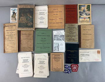
SoldRailroad Map and Ephemera Collection [133487]Four RR maps circa 1940-50; various RR-related ephemera including RR trade cards, RR fare guides, RR magazines, and reproduction Santa Fe signDate: Country (if not USA): State: City: Provenance: GarySee Sold Price
Sold9 Antiqe MapsIncludes: 1) A Map of a New Continent according to its Greatest Diametrical Length from the River la Plata to beyond the lake of Assiniboits. Gentleman's Magazine. London 1758. Eng. John Gibson afterSee Sold Price
SoldFour Antique Southern MapsFour Antique Southern Maps , comprising "A New Map of the Mississippi River from the Sea to Bayagoulas" by Thomas Kitchin (English, 1718-1784), published by "London Magazine", 1761, 7 in. x 9 in.; "ASee Sold Price
(CHINA -- FOOCHOW / FUZHOU.) Small archive comprising a(CHINA -- FOOCHOW / FUZHOU.) Small archive comprising a manuscript map and four pencil sketches drawn, most likely, by a Christian missionary. - Fuzhou, China, later part of the nineteenth century TheSee Sold Price
Southern Pacific RR Four Gateways to the Pacific Coast Brochure-1917JM Hobby Supply and Railroad Artifact Auctions4.4(126)See Sold PriceFeb 24, 2024
Chicago Burlington and Quincy RR July 5, 1894 Public TimetableJM Hobby Supply and Railroad Artifact Auctions4.4(126)See Sold PriceFeb 24, 2024
New York Central and Hudson River RR Public Timetable-November 3, 1901JM Hobby Supply and Railroad Artifact Auctions4.4(126)See Sold PriceFeb 24, 2024
PUNCH MAGAZINE 1869 Bound in Book Political CartoonsLuis Porretta Fine Arts4.3(10)See Sold PriceMar 02, 2024
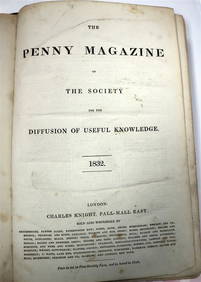
PENNY MAGAZINE 1832 & 1833 Full Bound Volumes Calf Binding THE PENNY MAGAZINELuis Porretta Fine Arts4.3(10)See Sold PriceMar 02, 2024
18TH C. ANTIQUE MAP: FRENCH & INDIAN WAR, FRAMEDThomaston Place Auction Galleries4.4(386)See Sold PriceFeb 24, 2024
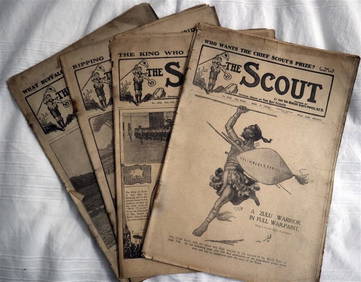
The SCOUT MAGAZINE Rare c1912 5 x Issues RARE!Luis Porretta Fine Arts4.3(10)See Sold PriceMar 02, 2024
Large Assortment of Railroad Items - Insulators, Globes, Hand Bell, Posters, Maps, Timetables,Rail & Road Auctions4.6(165)See Sold PriceMar 07, 2024
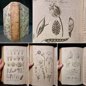
1797 Universal Magazine BOTANY PLATES Flowers FRUIT 12 Copper Engraved PlatesPrivate NY Collection4.2(21)See Sold PriceMar 01, 2024
Arrowsmith & Lewis - Map of North AmericaTrillium Antique Prints & Rare Books4.5(30)See Sold PriceFeb 24, 2024
Arrowsmith & Lewis - Map of the World on Mercator's ProjectionTrillium Antique Prints & Rare Books4.5(30)See Sold PriceFeb 24, 2024
Arrowsmith & Lewis - Map of LouisianaTrillium Antique Prints & Rare Books4.5(30)See Sold PriceFeb 24, 2024
Arrowsmith & Lewis - Map of the United StatesTrillium Antique Prints & Rare Books4.5(30)See Sold PriceFeb 24, 2024
STAR WARS: A NEW HOPE (1977) - Greg Hildebrandt-Signed Brothers Hildebrandt Poster with FourPropstore4.2(6)See Sold PriceMar 13, 2024


![[BASEBALL]. Group of Varied Ephemera, including: Sporting L... (1 of 2)](https://p1.liveauctioneers.com/928/318880/171361366_1_x.jpg?height=282&quality=70&version=1707501302)

![[CIGARETTE CARDS AND TOBACCO EPHEMERA]. A Group of Six Coll... (1 of 1)](https://p1.liveauctioneers.com/928/318880/171361529_1_x.jpg?height=282&quality=70&version=1707501302)


![[Vigilyansky, P.] «The Experience Of Sacred Geography» (1 of 4)](https://p1.liveauctioneers.com/3379/65136/32866292_1_x.jpg?height=282&quality=70&version=1418148303)


![Railroad Map and Ephemera Collection [133487] (1 of 1)](https://p1.liveauctioneers.com/2699/193399/97512484_1_x.jpg?height=282&quality=70&version=1612301936)