SoldGroup of Four Maps, ParisA Paris "Carte du Gouvernement" dated 1771, together with a pair of maps of St. Martin, St Berthelmy, and La Guadeloupe Vuillemin, together with another. 11.5" x 14" and 20" x 15".See Sold Price
SoldGroup of Four MapsMiscellaneous Group of Four Polychrome Maps, including two maps of Paris 17 1/4 x 21 1/2 inches and 16 1/2 x 22 inches, map of St Malo 16 x 20 inches, and map of Novi Belgii 18 1/2 x 21 m1/2 inches.See Sold Price
SoldGROUP OF FOUR OLD MAPSStar map, Venice, 1777. India-South East Asia to China-Idonesia, Venice, 1784. Rio de la Plata, Paris, 1704. „Magellanica“ depicting a sea battle, animals, tribal people, all surrounded bySee Sold Price
SoldGROUP OF FOUR HAND COLORED TOPOGRAPHICAL ENGRAVINGSAll depicting Paris and environs after drawings made by A. Pugin. Styled for Continental House. Verso on each with labels from WKA Old Prints and Maps. Each measuring 3” by 5 1/2”. Framed under PlSee Sold Price
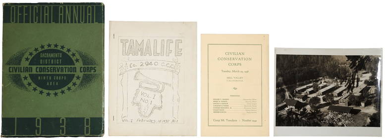
Sold[Louisiana Books][Louisiana Books], a group of four antique books including; Histoire de la Louisiane..., by Le Page du Pratz, Paris, 1758, (vol. 1 only), with fold-out maps; Norman's New Orleans and Environs..., publSee Sold Price
SoldGroup of 120 French PrintsA Group of 120 Antique French Prints, including 25 plates from Statistique Monumental de Paris, 1867; 92 plates with maps from Les Promenades de Paris, plate 24 x 16 in.; four prints from Jacques AndrSee Sold Price
SoldGroup of Four Maps of New MexicoFour maps of New Mexico. (1) New Mexico. From King's Handbook of the United States. Page 489 - 7 3/4 x 5 1/2 inches (2) "Sketch accompanying Col. Price's Despatch of 18 April 1847." Map of the BattleSee Sold Price
SoldGroup of Four Maps by Thomas Bowen (-1790), "A NewGroup of Four Maps by Thomas Bowen (-1790), "A New Acurate Map of North America… For Middleton's Compleat Geography," "Map of Europe," "A New Accurate Map of E. Moscovy or Russia in Europe," 174See Sold Price
Sold(GEOGRAPHY) A group of four maps.(GEOGRAPHY) A group of four geographical maps. Size of largest 24 x 33 1/4 inches.See Sold Price
(MAP, IBERIA) A group of four maps of Spain and(MAP, IBERIA) A group of four maps of Spain and Portugal. Framed and matted. Size of largest 26 x 30 inches.See Sold Price
SoldGrp: 4 Maps of Eastern Europe Romanian TransylvanGroup of four maps of Eastern Europe. One map by Gerard Valck and Peter Schenk depicting Serbia, Bulgaria, and Romania; one map by Gerard and Leonard Valck depicting Wallachia, Transylvania, and MoldoSee Sold Price
SoldGrp: 4 Maps of Canada w/ 1 Map of the Indian OceaGroup of four maps of Canada, including "The River St. Lawrence accurately drawn from d'Anville's Map," London: John Harrison, ca. 1780; New York State Library, "Champlain's Map of New France 1632," NSee Sold Price
SoldMAPS USED BY GEN. JOHN PERSHING IN THE PLANNING OF THEMAPS USED BY GEN. JOHN PERSHING IN THE PLANNING OF THE ST. MIHIEL OFFENSIVE Historic group of four maps used by A.E.F. Gen. John J. Pershing in the planning of the battle of Saint-Mihiel, Sep. 12-15,See Sold Price
Sold4pc New England ANTIQUE ENGRAVED MAPS 1886-1891Details: This lot consists of the antique lithographed maps shown in the corresponding image(s).This lot consists of a group of four maps of New England. Three are from Rand, McNally: "New Hampshire"See Sold Price
SoldGrp: 4 Maps of South America and the Caribbean SaGroup of four maps of South America and the Caribbean. Includes William Faden (1749–1836), "New Andalusia or Province of Guyana, according to the modern Division of the Spaniards, which extendsSee Sold Price
Sold(MAP, FRANCE) A group of 4 maps.(MAP, FRANCE) A group of four maps of France and French regions. Size of largest 13 3/4 x 17 1/4 inches.See Sold Price
RARE MAP - Homann Heirs (company): "Dominia Anglorum inRARE MAP - Homann Heirs (company): "Dominia Anglorum in America Septentrionali Specialibus Mappis Londini primum a Mollio…", group of four maps on a single sheet, which are based upon earlier maSee Sold Price
SoldMAPS USED BY GEN. JOHN PERSHING IN THE PLANNING OFTHEMAPS USED BY GEN. JOHN PERSHING IN THE PLANNING OFTHE ST. MIHIEL OFFENSIVE Historic group of four maps used by A.E.F. Gen. John J. Pershing in the planning of the battle of Saint-Mihiel, Sep. 12-15, 1See Sold Price
SoldFrance.- Provence.- A group of four framed maps ofNO RESERVE France.- Provence.- A group of four framed maps of Provence, including Pieter van den Keere's 'Provincia - La Provence', Jansson's 'Provincia - La Provence', Pierre Lemau de la Jaisse's 'PrSee Sold Price
SoldA GROUP OF FOUR ENGRAVED MAPS OF ARMENIA, 18TH CENTURYA GROUP OF FOUR ENGRAVED MAPS OF ARMENIA, 18TH CENTURY comprising: a) L'Armenie, la Georgie, et le Daghistan, engraving, plate: 44 x 56.5 cm (17 3/8 x 22 1/4 in.), likely from SARKIS BOGHOSSIAN (ARMENSee Sold Price
SoldGroup of four engraved maps in one frame including No.Group of four engraved maps in one frame including No. 13 Map of the State of Texas by Mitchells; Texas; Southern States, Western Section; and Map of Louisiana, Texas, and Arkansas, each map ss 9" x 1See Sold Price
SoldGROUP OF FOUR OLD PARIS FIGURAL CABINET PLATESFrench. 19th Century. Each with a different view. Diameter 8 3/4". (200/300)See Sold Price
SoldGroup of Four Old Paris Porcelain Perfume Bottles,Group of Four Old Paris Porcelain Perfume Bottles, early 19th c., each as found.See Sold Price
SoldGroup of Four Old Paris Porcelain Cups and SaucersGroup of Four Old Paris Porcelain Cups and Saucers, c. 1830, two with floral decoration, one with Gothic decoration and one magenta with gilt tracery. (8 Pcs.)See Sold Price
19thc Colton Map, Comparitive Size of Lakes & IslandsConnoisseur Auctions4(333)See Sold PriceFeb 24, 2024
General Books - Four Maps of Great Britain Designed by Matthew Paris About A.D. 1250TimeLine Auctions Ltd.4.5(183)See Sold PriceMar 08, 2024
Group of Four Framed Architectural Pieces to includeNadeau's Auction Gallery4.7(401)See Sold PriceFeb 24, 2024
Group of New York Central Railroad Paper - Rule Books, Employee Timetables, Stationary, Log Books,Rail & Road Auctions4.6(165)See Sold PriceMar 07, 2024
Eight Gulf, Mobile & Ohio Railroad Playing Card Decks - Alton Route Map and LogoRail & Road Auctions4.6(165)See Sold PriceMar 08, 2024
Four White Pass & Yukon Route Playing Card DecksRail & Road Auctions4.6(165)See Sold PriceMar 08, 2024
[LITHOGRAPHY]. [AFRICAN-AMERICANA]. BOILLY, Louis Leopold (...Potter & Potter Auctions4.6(539)See Sold PriceMar 07, 2024
[BASEBALL]. Group of Four Ceramic Souvenir Ornaments for Cu...Potter & Potter Auctions4.6(539)See Sold PriceMar 07, 2024
A group of four French Jaquard loom tapestriesAndrew Jones Auctions4.7(206)See Sold PriceFeb 29, 2024
Ten Sterling Silver Footed GobletsBroken Arch Auction Gallery NCFL#93994.6(294)See Sold PriceMar 04, 2024
GROUP OF FOUR CORINTHIAN COLUMN CANDLESTICKS AND PAIR OF GILT CANDELABRAS 18 X 15.5 LARGESTTHOS. CORNELL GALLERIES, LTD./CORNELL AUCTIONS, OBJECTS, AND TRADE4.5(313)See Sold PriceFeb 24, 2024


![[Louisiana Books] (1 of 2)](https://p1.liveauctioneers.com/268/27172/10261391_1_x.jpg?height=282&quality=70&version=1320494934)


![[LITHOGRAPHY]. [AFRICAN-AMERICANA]. BOILLY, Louis Leopold (... (1 of 4)](https://p1.liveauctioneers.com/928/318880/171361026_1_x.jpg?height=282&quality=70&version=1707501302)
![[BASEBALL]. Group of Four Ceramic Souvenir Ornaments for Cu... (1 of 5)](https://p1.liveauctioneers.com/928/318880/171361365_1_x.jpg?height=282&quality=70&version=1707501302)