Sold18/19th C. HC Map of Vegel and Velis Malaga18th/19th Century map of Vegel and Velis Malage, hand-colored bookplate, 13" x 18 1/2" (image), in frame 18" x 23", Georgius Hoefnagle. Good condition.See Sold Price
1575 Braun and Hogenberg Views of Southern Spain's Vegel and Velis Malaga -- Vegel [on sheet with]Title: 1575 Braun and Hogenberg Views of Southern Spain's Vegel and Velis Malaga -- Vegel [on sheet with] Velis Malaga Cartographer: Braun and Hogenberg Year / Place: 1575, Augsberg Map Dimension (in.See Sold Price
SoldBraun and Hogenberg View of Gibraltar and MalagaVegil and Velis Malaga. Georg Braun (1541-1622) & Frans Hogenburg (15350-1590). from Civitatus Orbis Terrarum. Hand-colored engraving. Cologne, c. 1572-1577. 16 1/4 x 22 inches sheet.See Sold Price
SoldThree 18/19th C. Maps of ConnecticutThe first CT map engraved by A. Doolittle, N. Haven 1795. The second published by Thomas Cowperthwait & Co. 1850. The town map by Litchfield Co. 1874, Whitlock's New Haven CT smallest frame; 16.5 x 19See Sold Price
Sold18th c. H/C Map Flamsteed and Fortin 177618th Century hand-colored engraved Celestial Map / Zodiac Map Entitled Le Lynx, Le Petit Lion (Lynx, Small Lion), plate 5, from "Atlas Céleste de Flamstéed, approuvé par l'Académie Royale des ScieSee Sold Price
18/19th C. HC Engraving of Rabbit, J.D. MeyerLate 18th/early 19th Century handcolored engraving of a rabbit by J.D. Meyer, 17" x 11 1/4". Good condition.See Sold Price
Braun & Hogenberg) Vegel; Velis Malaga[Braun (Georg and Franz Hogenberg)] Vegel; Velis Malaga,prospect of Malaga with view of Vegel and the north coast of Africa on the horizon, above, 2 engraved views on one sheet, by Hofnagle, 3See Sold Price
18/19TH C. MAPS OF THE WEST INDIES, 518/19TH C. MAPS OF THE WEST INDIES, 5, 10" X 8" TO 18 3/4" X 13":Sizes are plate sizes. St. St. Dominica, by M. Bellin, "Suivant la Decouverte de l'Anne 1492", 1754, hand colored, Tom XII No. 2, 9" XSee Sold Price
Sold17th c. Antique H/C Map of Ottoman / Turkish EmpireMap - Accuratissima et maxima totius Turcici Imperii tabula cum omnibus suis regionibus novissima delineatio | Title: Accuratissima et maxima totius Turcici Imperii tabula cum omnibus suis regionibusSee Sold Price
19th C. HC Engraving, "Map of Boston, 1875"19th Century handcolored engraving, "Map of Boston, 1875" by Sampson, Davenport & Co., 24" x 27 3/4"". Good condition.See Sold Price
SoldTwo 18/19Th C. German HC Bird EngravingsTitle: Two late 18th/early 19th C. German Bird Hand-colored Engravings, Date: Late 18th/early 19th Century, Medium: Hand-colored engravings, Paper size: 14 1/8 x 9 1/4, Condition: Good.See Sold Price
17th c. H/C Engraved Map DIVERSITÉ DES OMBRES ET DIVERS17th c. Hand-colored Engraved Double-page World Map Entitled DIVERSITÉ DES OMBRES ET DIVERSE SITUATION DES HABITANS DE LA TERRE by Claude Buy de Mornas (17XX-1783), 1761 | One of 17 hand-coloured douSee Sold Price
Original 18th c. H/C Engraved Lattré Map of EuropeAntique Original Hand-colored Engraved Map of Europe from PETIT ATLAS MODERNE ou collection de cartes élémentaires dédié à la jeunesse | Engraved and published in Paris by Jean Lattr�See Sold Price
Sold20th C. HC Litho of Map of Boston Harbor20th Century hand-colored lithograph of map of Boston Harbor, by Barre publishers, 34 3/4" x 23", unframed. Good condition.See Sold Price
SoldOriginal 18th c. H/C Engraved Lattré Map of EuropeAntique Original Hand-colored Engraved Map of Europe from PETIT ATLAS MODERNE ou collection de cartes élémentaires dédié à la jeunesse | Engraved and published in Paris by Jean Lattr [Chez LattreSee Sold Price
18/19TH C. WEST INDIES MAPS, 218/19TH C. WEST INDIES MAPS, 2, 18" X 21 & 19" X 25": ANTILLES BY S. ROBERT, 1750; BAHAMAS, C. 1827:Both hand colored; Antilles Islands, signed and dated, 19 1/4" x 24 5/8", 21 3/4" x 32 1/4" paper, cSee Sold Price
SoldLOT (4) H/C TERRESTRIAL MAPS, 20TH C.LOT (4) H/C DECORATIVE TERRESTRIAL MAPS, 20TH C. SIGHT 16" X 20"See Sold Price
SoldMAP: NOUVELLE FRANCE, C. 1656, HC ENGRAVINGTitle: Map: Le Canada, ou Nouvelle France, Pub: Nicolas Sanson, Date: Circa 1656, Medium: HC Engraving, Paper size: 18 x 23 1/2, Inscribed: Cartographer and engraver identified within matrix, ConditioSee Sold Price
SoldMap: County Of Wiltshire, 17Th C., HC EngravingTitle: Map of County of Wiltshire, Printmaker: Christopher Saxton, Date: 17th Century, Medium: Hand-colored engraving, Sight size: 16 1/2 x 18 1/2, Inscribed: Engraver identified within matrix, ConditSee Sold Price
LOT (2) H/C FRENCH GENRE MEZZO TINTS, 18/19TH C.LOT (2) H/C FRENCH GENRE MEZZO TINTS, 18/19TH C. 19" X 14"See Sold Price
SoldMap: Duche De Bretaigne, 17Th C, HC EngravingTitle: Map: Duche de Bretaigne, Printmaker: Joannus Jansson, Date: 17th Century, Medium: Hand-colored engraving, Sight size: 16 1/4 x 21 1/2, Inscribed: Engraver identified within matrix, Condition: GSee Sold Price
SoldH/C MAP HUNTINGTON TO IPSWICH BY JOHN OGILBYH/C MAP HUNTINGTON TO IPSWICH BY JOHN OGILBY COSMOGRAPHER 18TH C, SIGHT 13" X 18"See Sold Price
17TH C. WORLD MAP BY NICOLAES VISSCHER (NETHERLANDS, 1618-1709)Thomaston Place Auction Galleries4.4(394)See Sold PriceFeb 24, 2024
LATE 17TH C. FRENCH MAP OF THE NEW WORLD BY ALEXIS-HUBERT JAILLOT (1632-1712)Thomaston Place Auction Galleries4.4(394)See Sold PriceFeb 24, 2024
17TH C. ANTIQUE MAP SIEGE OF LA ROCHELLE, FRANCE, FRAMEDThomaston Place Auction Galleries4.4(394)See Sold PriceFeb 24, 2024
EARLY 18TH C. MAP OF ITALY, FRAMEDThomaston Place Auction Galleries4.4(394)See Sold PriceFeb 24, 2024
LATE 16TH C. MAP OF SCOTLAND BY MERCATOR, FRAMEDThomaston Place Auction Galleries4.4(394)See Sold PriceFeb 24, 2024
17TH C. MAP OF THE BERKSHIRES BY JOHN SPEED, FRAMEDThomaston Place Auction Galleries4.4(394)See Sold PriceFeb 24, 2024
18TH C. ANTIQUE MAP: FRENCH & INDIAN WAR, FRAMEDThomaston Place Auction Galleries4.4(394)See Sold PriceFeb 24, 2024
17TH C. ENGLISH LINEAR MAP BY OGILBY, FRAMEDThomaston Place Auction Galleries4.4(394)See Sold PriceFeb 24, 2024
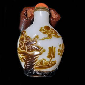
ANTIQUE CHINESE PEKING GLASS SNUFF BOTTLE 18-19TH C BROWN WHITE PEOPLE BOATSNoble House Collection Gallery4.6(124)See Sold PriceFeb 28, 2024
Johann Homann Hand-Colored Map Engraving, c. 1730Auctions at Showplace4.6(744)See Sold PriceMar 17, 2024
Willem Blaeu, Etc. 17th C. Antiquarian Maps, 2Auctions at Showplace4.6(744)See Sold PriceMar 17, 2024
18-19th C. Chinese Export Porcelain Famille Rose PlateFortune Auction Gallery4.2(92)See Sold PriceMar 09, 2024
Pr. of 18-19th C. Chinese Export Porcelain B&W VassFortune Auction Gallery4.2(92)See Sold PriceMar 09, 2024
Pr. of 18-19th C. Chinese Porcelain Famille JauneFortune Auction Gallery4.2(92)See Sold PriceMar 09, 2024
18-19th C. Chinese Cobalt Blue Glaze Wucai VaseFortune Auction Gallery4.2(92)See Sold PriceMar 09, 2024
Two (2) Antique 18th C. Copper Engraved Framed Maps - America & EuropeMagnusson Art Group4.5(53)See Sold PriceMar 14, 2024
Perry, Matthew C. 1856 Large Map. Shah Bay, Lew Chew I. JapanAlbion Auctions4.7(341)See Sold PriceMar 01, 2024


![1575 Braun and Hogenberg Views of Southern Spain's Vegel and Velis Malaga -- Vegel [on sheet with] (1 of 1)](https://p1.liveauctioneers.com/5584/299373/159356238_1_x.jpg?height=282&quality=70&version=1692738248)