ATLAS of ANTIENT GEOGRAPHY by SAMUEL BUTLER 1843John McInnis Auctioneers,LLC4.5(505)See Sold PriceFeb 24, 2024
18TH C. ANTIQUE MAP: FRENCH & INDIAN WAR, FRAMEDThomaston Place Auction Galleries4.4(393)See Sold PriceFeb 24, 2024
Rand McNally Railroad Map Cabinet w/ 21 Railroad MapsRail & Road Auctions4.6(165)See Sold PriceMar 08, 2024
Keith Haring - Ink on New York Map, Best Buddies, Inscribed, Signed, and DatedSapphire Auction Gallery4(67)See Sold PriceMar 02, 2024
LATE 17TH C. FRENCH MAP OF THE NEW WORLD BY ALEXIS-HUBERT JAILLOT (1632-1712)Thomaston Place Auction Galleries4.4(393)See Sold PriceFeb 24, 2024
Central Railroad of New Jersey Map of Sandy Hook Route-ca. 1903JM Hobby Supply and Railroad Artifact Auctions4.4(127)See Sold PriceFeb 24, 2024
Lot of Six Mixed Atlas Box Cars-HO Scale-New in BoxJM Hobby Supply and Railroad Artifact Auctions4.4(127)See Sold PriceFeb 25, 2024
Rand McNally/Santa Fe Railroad Map of Iowa-1912JM Hobby Supply and Railroad Artifact Auctions4.4(127)See Sold PriceFeb 24, 2024
NICOLAES VISSCHER (NETHERLANDS, 1618-1709) MAP OF THE NEW WORLDThomaston Place Auction Galleries4.4(393)See Sold PriceFeb 24, 2024
17TH C. WORLD MAP BY NICOLAES VISSCHER (NETHERLANDS, 1618-1709)Thomaston Place Auction Galleries4.4(393)See Sold PriceFeb 24, 2024
Lot of Six Mixed Atlas Cabooses-HO Scale-New in BoxJM Hobby Supply and Railroad Artifact Auctions4.4(127)See Sold PriceFeb 25, 2024
SoldLate 16th c. hand colored map of IrelandGerhard Mercator (German-Flemish, 1512-1594), late 16th century hand-colored map of Ireland in two parts, titled 'Irlandiae Regnum Miliaria Irlandica Communia,' 17"h x 21"w sight of each sheet, overalSee Sold Price
Sold[Map] G. Mercator, "Germania" late 16th centuryhand-colored engraving, 14 x 19 in., framedSee Sold Price
Sold2 Antique Maps, c. 1600, Florence & YorkshireTwo Antique Handcolored Maps, c. 1600, Florence by Don Stephano, late 16th c. & Yorkshire by John Speed, early 17th c. {ACGQ7041/2} (TC ) Dimensions: Florence 13.5 x 18.5, framed 20x25; the YorkshireSee Sold Price
SoldGerard Mercator, (2) 16th c. maps of British IslesGerard Mercator, (2) 16th c. maps of British Isles, Gerard Mercator (German, 1512-1594), half sheets of Scotland and England, c. 1580s, 19.5"h x 22.5"w (sheet), unframed Provenance: Property from a maSee Sold Price
SoldMap grouping by Jodocus HondiusGrouping of 4-small maps by Jodocus Hondius including; map of the world, Africa, Sicily and Crete. Maps are hand-colored and measure 3.5" x 5" and are framed. c.late 16th early 17th century. $300-400See Sold Price
SoldFramed Map Hannonia NamurcumFramed map Hannonia Namurcum detailed map of regional Germany by Gerard Mercator, Belgium, 16th c., no date 14 3/4" x 19 1/2" site, matted and framed 20 1/2" x 25". CONDITION: Center fold line with teSee Sold Price
SoldABRAHAM ORTELIUS LATE 16TH C. MAP OF PERUDidaco Mendezio, circa 1584Dimensions: H 16.5" W 12.5"Note: All items are sold as-is, where-is. Any condition report is a courtesy to the buyer and should not be taken as fact. Please contact the auctSee Sold Price
Sold19th Century Persian Miniature PaintingAntique Persian miniature, depicting a scene from the life of Sultan Selim II, in the style of the late 16th c. miniaturist, Nigari; framed; 8 1/2" x 4 3/4" (sight, approx.)See Sold Price
19th Century Persian Miniature PaintingAntique Persian miniature, depicting a scene from the life of Sultan Selim II, in the style of the late 16th c. miniaturist, Nigari; framed; 8 1/2" x 4 3/4" (sight, approx.)See Sold Price
19th Century Persian Miniature PaintingAntique Persian miniature, depicting a scene from the life of Sultan Selim II, in the style of the late 16th c. miniaturist, Nigari; framed; 8 1/2" x 4 3/4" (sight, approx.)See Sold Price
SoldGEORG BRAUN & FRANS HOGENBERG FRAMED 16TH C. MAPGEORG BRAUN & FRANS HOGENBERG FRAMED 16TH C. MAP Map engraving by Georg Braun and Frans Hogenberg, of the French cities of Nimes and Bordeaux. Set in a wooden frame under glass. Circa 16th century.&nbSee Sold Price
BRAUN & HOGENBERG 16TH C. MAP OF NIMES & BORDEAUXGEORG BRAUN & FRANS HOGENBERG FRAMED 16TH C. MAP OF NIMES & BORDEAUX Map engraving by Georg Braun and Frans Hogenberg, of the French cities of Nimes and Bordeaux. Set in a wooden frame under glass. CiSee Sold Price
SoldSAXTON, CHRISTOPHER| (16th Century English) AntiqSAXTON, CHRISTOPHER| (16th Century English) Antiquarian map (possibly Scotland) framed, hand colored engraving on paper, signed lower left, dated 1577 upper left. CONDITION: Fair, several areas of papSee Sold Price
SoldAbraham Ortelius Rare Map of Poland Late 16th C.Abraham Ortelius Scarce map of Poland and Lithuania during the late 16th century. Titled "Poloniae, Litvaniaeq. Descriptio". The map shows major cities and towns, as well as geographical features. IncSee Sold Price
SoldAbraham Ortelius Rare Map of Poland Late 16th C.Abraham Ortelius Scarce map of Poland and Lithuania during the late 16th century. Titled "Poloniae, Litvaniaeq. Descriptio". The map shows major cities and towns, as well as geographical features. 22.See Sold Price
SoldPair of Framed Maps, Late 19th c.,Pair of Framed Maps, Late 19th c., the first, "County map of England and Wales", published by S. Augustus Mitchell, Philadelphia, 1870, DOA 22.5"h x 19.5"w; the second, "Denmark w/Sleswick-Holstein",See Sold Price
SoldAbraham Ortelius Scotiae tabula, map of Scotland, 15thAbraham Ortelius Scotiae tabula, map of Scotland, 15th - 16th C., hand-colored engraving, plate size 14" x 18 3/4". Provenance: Estate of Mark W. Izard MD, Cider Brook Road, Avon, CT.See Sold Price
Sold6 EARLY 20TH C MOUNTED PHOTOGRAPHS, 19TH C SHIPSBUILT IN KINGSTON, MASS AND A LATE 19TH C MAP OF KINGSTON, MASS. ALL ARE FRAMED. MAP IS 17" X 12 3/4". PHOTOS ARE APPROX. 9 1/2" X 11 1/2" AND SHOW THE SHIPS ANN & MARY, STAFFORD, LEODES, BRIG HELEN,See Sold Price
Sold16TH C. MAP OF PERU16th century original colored map of Peru by Dutch cartographer Willem Janszoon Blaeu (1571-1638). Good condition, with some light foxing at edges and small tears at center crease edges. Framed and hoSee Sold Price
SoldManner of the Bassano Family (Venetian, late 16th c.)Manner of the Bassano Family (Venetian, late 16th c.), "Scenes of the Vintage", 19th c., oil on panel, unsigned, 14 1/8 in. x 20 1/8 in., framed. Provenance: Estate of Margaret "Peggy" Chew Welch (192See Sold Price
SoldOld Master Engraving, Theodore de Bry Florida MapManner of Thomas de Bry (1528-1598) From the Grand Voyages, plate number V "Galli ad Regalem Perveniunt" (The French reach Port Royal) hand colored, late 16th C. Unframed, stains and losses to edges.See Sold Price
SoldGilt Framed Late 18th-Early 19th C. MapTribes of Issachvar & Amnassen (Palestine) Approx. 4" x 6"See Sold Price
SoldLate 20th C. Framed and Matted Map of EnglandLate 20th Century framed and matted map of England. Dimensions: onsite 18 1/2" x 27 1/2", overall 36" x 28". Condition: very good.See Sold Price
Sold16TH C. PERSIAN MANUSCRIPT PAGESlaughter of brahman bull, Shiraz, late 16th c. Gouache and ink with gilt details on paper (framed) 8 1/4" x 5 3/4" (sight) Exhibition: Olsen Traveling Exhibition, Olsen Foundation, Bridgeport, CT NorSee Sold Price
Large 15 /16th-c. or later Crystal Sukhothai Buddha-Authentic Reclining Masterpiece-traces/gildingThe Buddha Gallery4.4(29)See Sold PriceMar 13, 2024
LATE 18TH C. VERY LARGE CHART OF NORTHEAST CANADA BY DES BARRES (1721-1824), 1780, FRAMEDThomaston Place Auction Galleries4.4(393)See Sold PriceFeb 24, 2024
LARGE LATE 17TH C. DUTCH CHART OF CANADA, GREAT LAKES, NEW FRANCE, LABRADOR, HUDSON BAY, BY PIERREThomaston Place Auction Galleries4.4(393)See Sold PriceFeb 24, 2024
LATE 17TH C. FRENCH MAP OF THE NEW WORLD BY ALEXIS-HUBERT JAILLOT (1632-1712)Thomaston Place Auction Galleries4.4(393)See Sold PriceFeb 24, 2024
17TH C. ANTIQUE MAP SIEGE OF LA ROCHELLE, FRANCE, FRAMEDThomaston Place Auction Galleries4.4(393)See Sold PriceFeb 24, 2024
EARLY 18TH C. MAP OF ITALY, FRAMEDThomaston Place Auction Galleries4.4(393)See Sold PriceFeb 24, 2024
LATE 16TH C. MAP OF SCOTLAND BY MERCATOR, FRAMEDThomaston Place Auction Galleries4.4(393)See Sold PriceFeb 24, 2024
17TH C. MAP OF THE BERKSHIRES BY JOHN SPEED, FRAMEDThomaston Place Auction Galleries4.4(393)See Sold PriceFeb 24, 2024
18TH C. ANTIQUE MAP: FRENCH & INDIAN WAR, FRAMEDThomaston Place Auction Galleries4.4(393)See Sold PriceFeb 24, 2024
17TH C. ENGLISH LINEAR MAP BY OGILBY, FRAMEDThomaston Place Auction Galleries4.4(393)See Sold PriceFeb 24, 2024
Early 20th C. Framed Pastel "Kids on Fence"Premier Auction Galleries4.4(331)See Sold PriceMar 09, 2024
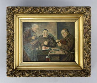
"Monks Dining" Print on Canvas Late 19th C.Epic Auctions and Estate Sales4.6(210)See Sold PriceMar 02, 2024
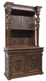
MONUMENTAL RENAISSANCE REVIVAL FIGURAL CARVED OAK SIDEBOARDAustin Auction Gallery4.7(1.2k)See Sold PriceFeb 25, 2024
Minton's Art Pottery Studio Henry S. Marks Framed TileLion and Unicorn4.8(1.9k)See Sold PriceFeb 25, 2024
Minton's Art Pottery Studio Henry S. Marks Framed TileLion and Unicorn4.8(1.9k)See Sold PriceFeb 25, 2024
Two (2) Antique 18th C. Copper Engraved Framed Maps - America & EuropeMagnusson Art Group4.5(53)See Sold PriceMar 14, 2024
Woman & Fisherman, A Late 19th C. Oil On Canvas Framed Painting, SignedFive Star Auctions4.2(3)See Sold PriceFeb 29, 2024
American School, "Boat on a Lake," late 19th c., H.- 14 in. W.- 22 in., Framed- H. 16 in., W.- 23Crescent City Auction Gallery4.3(231)See Sold PriceMar 08, 2024
16th C North Italy Wood Icon w/ Mary & ChristWorld Auction Gallery LLC4.7(264)See Sold PriceMar 10, 2024


![[Map] G. Mercator, "Germania" late 16th century (1 of 3)](https://p1.liveauctioneers.com/523/48656/22613830_1_x.jpg?height=282&quality=70&version=1386104939)