MAP - PIETER SCHENK / VALK / JANSSEN Hand Colored superb Map Central Italy c1702Luis Porretta Fine Arts4.3(10)See Sold PriceMar 02, 2024
CHARLES ROLLIN c1828 Ceasar Hand Colored Africa Military MapLuis Porretta Fine Arts4.3(10)See Sold PriceMar 02, 2024
MAP - Dufour, A. H. ( Malte / Brun ) :MAP - ESPAGNE PARTIE SUD DIVISEE EN PROVINCES ANCIENNES ( MAPLuis Porretta Fine Arts4.3(10)See Sold PriceMar 02, 2024
RIGOBERT BONNE c1787 Original Colored Map Germany & Region 15" x 12"Luis Porretta Fine Arts4.3(10)See Sold PriceMar 02, 2024
AMBROISE TARDIEU c1822 Napoleonic War Map GermanyLuis Porretta Fine Arts4.3(10)See Sold PriceMar 02, 2024
MAP - AMBROISE TARDIEU c1822 Napoleonic Miltary Map GermanyLuis Porretta Fine Arts4.3(10)See Sold PriceMar 02, 2024
1822 Rare Map by Ambroise Tardieu Napoleon Caldiero Battle of Vento 17" x 11Luis Porretta Fine Arts4.3(10)See Sold PriceMar 02, 2024
PIETER SCHENK / VALK / JANSSEN Hand Colored Map of Rhodes Greece ca1702 vgcLuis Porretta Fine Arts4.3(10)See Sold PriceMar 02, 2024
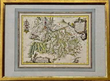
Map: Carte du Canton de Bale, Jacques Clermont, Paris, 1788Kensington Estate Auction4.6(219)See Sold PriceFeb 26, 2024
Original 18th c. H/C Engraved Lattré Map of EuropeAntique Original Hand-colored Engraved Map of Europe from PETIT ATLAS MODERNE ou collection de cartes élémentaires dédié à la jeunesse | Engraved and published in Paris by Jean Lattr�See Sold Price
SoldOriginal 18th c. H/C Engraved Lattré Map of EuropeAntique Original Hand-colored Engraved Map of Europe from PETIT ATLAS MODERNE ou collection de cartes élémentaires dédié à la jeunesse | Engraved and published in Paris by Jean Lattr [Chez LattreSee Sold Price
Druru Map of Eastern Europe and TurkeyDRURY, Andrew (Late 18th Century).Map of the present seat of war between the Russians, Poles and Turks...Engraved map with original hand color in outline on four sheets.London, c. 1770-1790.35 1/2" xSee Sold Price
SoldPair of 18th c. LA PÉROUSE Map Engravings -Plates 51&52Pair of the Original 18th c. LA PÉROUSE copperplate engraved maps - Plates 51 & 52 - from The Voyage of La Pérouse Round the World in the Years 1785, 1786, 1787, and 1788 | Published as the Act DireSee Sold Price
Pair of 18th c. LA PÉROUSE Map Engravings: The Voyage oPair of the Original 18th c. LA PÉROUSE copperplate engraved maps - Plates 51 & 52 - from The Voyage of La Pérouse Round the World in the Years 1785, 1786, 1787, and 1788 | Published as the Act DireSee Sold Price
SoldFive unframed engraved maps of Europe, 18th c., tFive unframed engraved maps of Europe, 18th c., together with an unframed later map of Turkey, a map of Steuben County, New York, and a framed map of Gascogne.See Sold Price
Early 18thc Engraved Maps, Road to LondonOriginal early 18th century engravings, Emanuel Bowen ( 1714 - 1767 ) "Map of the Road from London to Dover in Kent". 7 1/4" X 9 3/4" along with "Map of the Road from London to Hith." 7 1/4" X 4 3/4".See Sold Price
Early 18thc Engraved Maps, Road to LondonOriginal early 18th century engravings, Emanuel Bowen ( 1714 - 1767 ) "Map of the Road from London to Dover in Kent". 7 1/4" X 9 3/4" along with "Map of the Road from London to Hith." 7 1/4" X 4 3/4".See Sold Price
Early 18thc Engraved Maps, Road to LondonOriginal early 18th century engravings, Emanuel Bowen ( 1714 - 1767 ) "Map of the Road from London to Dover in Kent". 7 1/4" X 9 3/4" along with "Map of the Road from London to Hith." 7 1/4" X 4 3/4".See Sold Price
SoldEarly 18thc Engraved Maps, Road to LondonOriginal early 18th century engravings, Emanuel Bowen ( 1714 - 1767 ) "Map of the Road from London to Dover in Kent". 7 1/4" X 9 3/4" along with "Map of the Road from London to Hith." 7 1/4" X 4 3/4".See Sold Price
Early 18thc Engraved Maps, Road to LondonOriginal early 18th century engravings, Emanuel Bowen ( 1714 - 1767 ) "Map of the Road from London to Dover in Kent". 7 1/4" X 9 3/4" along with "Map of the Road from London to Hith." 7 1/4" X 4 3/4".See Sold Price
Early 18thc Engraved Maps, Road to LondonOriginal early 18th century engravings, Emanuel Bowen ( 1714 - 1767 ) "Map of the Road from London to Dover in Kent". 7 1/4" X 9 3/4" along with "Map of the Road from London to Hith." 7 1/4" X 4 3/4".See Sold Price
Early 18thc Engraved Maps, Road to LondonOriginal early 18th century engravings, Emanuel Bowen ( 1714 - 1767 ) "Map of the Road from London to Dover in Kent". 7 1/4" X 9 3/4" along with "Map of the Road from London to Hith." 7 1/4" X 4 3/4".See Sold Price
Early 18thc Engraved Maps, Road to LondonOriginal early 18th century engravings, Emanuel Bowen ( 1714 - 1767 ) "Map of the Road from London to Dover in Kent". 7 1/4" X 9 3/4" along with "Map of the Road from London to Hith." 7 1/4" X 4 3/4".See Sold Price
Early 18thc Engraved Maps, Road to LondonOriginal early 18th century engravings, Emanuel Bowen ( 1714 - 1767 ) "Map of the Road from London to Dover in Kent". 7 1/4" X 9 3/4" along with "Map of the Road from London to Hith." 7 1/4" X 4 3/4".See Sold Price
Early 18thc Engraved Maps, Road to LondonOriginal early 18th century engravings, Emanuel Bowen ( 1714 - 1767 ) "Map of the Road from London to Dover in Kent". 7 1/4" X 9 3/4" along with "Map of the Road from London to Hith." 7 1/4" X 4 3/4".See Sold Price
Early 18thc Engraved Maps, Road to LondonOriginal early 18th century engravings, Emanuel Bowen ( 1714 - 1767 ) "Map of the Road from London to Dover in Kent". 7 1/4" X 9 3/4" along with "Map of the Road from London to Hith." 7 1/4" X 4 3/4".See Sold Price
Early 18thc Engraved Maps, Road to LondonOriginal early 18th century engravings, Emanuel Bowen ( 1714 - 1767 ) "Map of the Road from London to Dover in Kent". 7 1/4" X 9 3/4" along with "Map of the Road from London to Hith." 7 1/4" X 4 3/4".See Sold Price
Early 18thc Engraved Maps, Road to LondonOriginal early 18th century engravings, Emanuel Bowen ( 1714 - 1767 ) "Map of the Road from London to Dover in Kent". 7 1/4" X 9 3/4" along with "Map of the Road from London to Hith." 7 1/4" X 4 3/4".See Sold Price
Early 18thc Engraved Maps, Road to LondonOriginal early 18th century engravings, Emanuel Bowen ( 1714 - 1767 ) "Map of the Road from London to Dover in Kent". 7 1/4" X 9 3/4" along with "Map of the Road from London to Hith." 7 1/4" X 4 3/4".See Sold Price
Early 18thc Engraved Maps, Road to LondonOriginal early 18th century engravings, Emanuel Bowen ( 1714 - 1767 ) "Map of the Road from London to Dover in Kent". 7 1/4" X 9 3/4" along with "Map of the Road from London to Hith." 7 1/4" X 4 3/4".See Sold Price
Early 18thc Engraved Maps, Road to LondonOriginal early 18th century engravings, Emanuel Bowen ( 1714 - 1767 ) "Map of the Road from London to Dover in Kent". 7 1/4" X 9 3/4" along with "Map of the Road from London to Hith." 7 1/4" X 4 3/4".See Sold Price
Early 18thc Engraved Maps, Road to LondonOriginal early 18th century engravings, Emanuel Bowen ( 1714 - 1767 ) "Map of the Road from London to Dover in Kent". 7 1/4" X 9 3/4" along with "Map of the Road from London to Hith." 7 1/4" X 4 3/4".See Sold Price
Early 18thc Engraved Maps, Road to LondonOriginal early 18th century engravings, Emanuel Bowen ( 1714 - 1767 ) "Map of the Road from London to Dover in Kent". 7 1/4" X 9 3/4" along with "Map of the Road from London to Hith." 7 1/4" X 4 3/4".See Sold Price
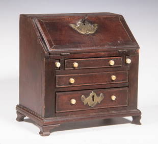
RARE MINIATURE QUEEN ANNE SLANT FRONT DESKThomaston Place Auction Galleries4.4(393)See Sold PriceFeb 24, 2024
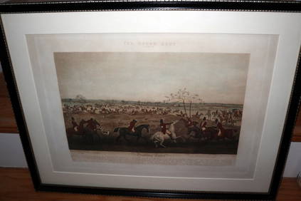
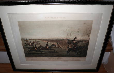
HENRY ALKEN / LEWIS Original 1835 Hand Colored Engraving Quorn Hunt DrawingLuis Porretta Fine Arts4.3(10)See Sold PriceMar 02, 2024
HENRY ALKEN / LEWIS Original 1835 Hand Colored Engraving Quron Hunt Snob Is BeatLuis Porretta Fine Arts4.3(10)See Sold PriceMar 02, 2024
Two (2) Antique 18th C. Copper Engraved Framed Maps - America & EuropeMagnusson Art Group4.5(53)See Sold PriceMar 14, 2024
1722 POMPONII MELA De Situ Orbis ARMORIAL VELLUM BINDING antiqueJasper524.5(9.9k)See Sold PriceFeb 27, 2024
1816 MAP SOUTHERN PART OF RUSSIA or MUSCOVY in EUROPE copper engraving ANTIQUEJasper524.5(9.9k)See Sold PriceFeb 27, 2024
1744 ROMAN HISTORY ARMORIAL VELLUM BINDING ILLUSTRATED w/ MAP antique by FLORUSJasper524.5(9.9k)See Sold PriceFeb 27, 2024
1675 ELZEVIER JULIUS CAESAR antique ILLUSTRATED w/ MAPS ROMAN HISTORYJasper524.5(9.9k)See Sold PriceFeb 27, 2024
1704 DESCRIPTION OF ALL THE SEATS OF THE PRESENT WARS OF EUROPE antique w/ MAPSJasper524.5(9.9k)See Sold PriceFeb 27, 2024
Medicine.- Kennedy (James) The History of the Contagious Cholera, first edition, 1831 & others (11)Forum Auctions4.3(53)See Sold PriceFeb 29, 2024
Railways & Transport.- [Prospectus] The Dorking, Brighton, and Arundel Atmospheric Railway, byForum Auctions4.3(53)See Sold PriceFeb 29, 2024
Western Africa by Edward Weller. Early British/French settlements 1860 old mapJasper524.5(9.9k)See Sold PriceFeb 28, 2024
La Nubia ed Abissinia. Red Sea Ethiopia Sudan Eritrea Arabia. ZATTA 1785 mapJasper524.5(9.9k)See Sold PriceFeb 28, 2024
Western Africa by Edward Weller. Early British/French settlements 1859 old mapJasper524.5(9.9k)See Sold PriceFeb 28, 2024
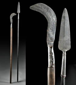
18th C. European Iron Polearms - Spear + BillhookArtemis Fine Arts4.8(1.4k)See Sold PriceFeb 26, 2024
ANTIQUE ROMAN ARMORIAL VELLUM BINDING, 1744, ILLUSTRATED WITH AN ANTIQUE MAP BY FLORUSNY Elizabeth 4.2(86)See Sold PriceMar 03, 2024
ANTIQUE GEOMORPHOLOGY: 1782 POMPONII MELA DE SITU ORBIS ARMORIAL VELLUM BINDINGNY Elizabeth 4.2(86)See Sold PriceMar 03, 2024
POMPONIUS MELA 1784 ANTIQUE SCHOOL PRIMED VELLUM BINDING CLASSICAL LATIN WORKSNY Elizabeth 4.2(86)See Sold PriceMar 03, 2024
ARMORIAL BINDING ROMAN HISTORY, 1773: ILLUSTRATED ANTIQUE LIVES OF EMPERORS NEPOSNY Elizabeth 4.2(86)See Sold PriceMar 03, 2024
PUBLIUS TERENTIUS AFER COMOEDIAE SEX, TWO VOLUMES OF ANTIQUE POETRY, 1779 TERENCE COMEDIESNY Elizabeth 4.2(86)See Sold PriceMar 03, 2024


![Railways & Transport.- [Prospectus] The Dorking, Brighton, and Arundel Atmospheric Railway, by (1 of 1)](https://p1.liveauctioneers.com/5458/319736/171654703_1_x.jpg?height=282&quality=70&version=1708010439)