ATLAS of ANTIENT GEOGRAPHY by SAMUEL BUTLER 1843John McInnis Auctioneers,LLC4.5(505)See Sold PriceFeb 24, 2024
18TH C. ANTIQUE MAP: FRENCH & INDIAN WAR, FRAMEDThomaston Place Auction Galleries4.4(393)See Sold PriceFeb 24, 2024
Rand McNally Railroad Map Cabinet w/ 21 Railroad MapsRail & Road Auctions4.6(165)See Sold PriceMar 08, 2024
Keith Haring - Ink on New York Map, Best Buddies, Inscribed, Signed, and DatedSapphire Auction Gallery4(67)See Sold PriceMar 02, 2024
LATE 17TH C. FRENCH MAP OF THE NEW WORLD BY ALEXIS-HUBERT JAILLOT (1632-1712)Thomaston Place Auction Galleries4.4(393)See Sold PriceFeb 24, 2024
Central Railroad of New Jersey Map of Sandy Hook Route-ca. 1903JM Hobby Supply and Railroad Artifact Auctions4.4(127)See Sold PriceFeb 24, 2024
Lot of Six Mixed Atlas Box Cars-HO Scale-New in BoxJM Hobby Supply and Railroad Artifact Auctions4.4(127)See Sold PriceFeb 25, 2024
Rand McNally/Santa Fe Railroad Map of Iowa-1912JM Hobby Supply and Railroad Artifact Auctions4.4(127)See Sold PriceFeb 24, 2024
NICOLAES VISSCHER (NETHERLANDS, 1618-1709) MAP OF THE NEW WORLDThomaston Place Auction Galleries4.4(393)See Sold PriceFeb 24, 2024
17TH C. WORLD MAP BY NICOLAES VISSCHER (NETHERLANDS, 1618-1709)Thomaston Place Auction Galleries4.4(393)See Sold PriceFeb 24, 2024
Lot of Six Mixed Atlas Cabooses-HO Scale-New in BoxJM Hobby Supply and Railroad Artifact Auctions4.4(127)See Sold PriceFeb 25, 2024
Sold3 PENN PRINT MAPS FRAMEDThree framed decorative Map reprints by Penn Maps, New York, c. 1960. Colors are very vivid and prints are in beautiful condition. All in matching wood frames. 1- Map of Asia, by the Famous Blaeu FamiSee Sold Price
Sold3 PENN PRINT MAPS FRAMEDThree framed decorative Map reprints by Penn Maps, New York, c. 1960. Colors are very vivid and prints are in beautiful condition. All in matching wood frames. 1- The Holy Land (Palestine) by AbrahamSee Sold Price
SoldScarce Gettysburg Battlefield Map, T. Ditterline, 1863 Scarce Gettysburg Battlefield Map, T. Ditterline, 1863 Ditterline, T. Sketch of the Battles of Gettysburg, July 1st, 2nd, and 3d, 1863…Accompanied by an Explanatory Map. New York: C.A. Alvord, 186See Sold Price
SoldScarce Gettysburg Battlefield Map, T. Ditterline, 1863 Scarce Gettysburg Battlefield Map, T. Ditterline, 1863 Ditterline, T. Sketch of the Battles of Gettysburg, July 1st, 2nd, and 3d, 1863…Accompanied by an Explanatory Map. New York: C.A. Alvord, 18See Sold Price
Revolutionary War Engraved Map of the Battle of BunkerA Plan of the Action at Breeds Hill on the 17th of June 1775, Pl. 1. Engraved map. New York: C Smith, c. 1796. 9 3/4 x 9 inches sheet. Between the American Forces and British Troops (Erroneously calleSee Sold Price
Soldc. 1732-1780, A Draught of New YorkEarly Map of New York c. 1732-1780, "A Draught of New York from the Hook to New York Town", by Mark Tiddeman, Very Good. 18" x 23", moderate toning, some dampstaining, paper loss at center and along tSee Sold Price
SoldMap of Bronx New York c 1994Map of Bronx New York c 1994. Framed in a gold toned metal frame, printed map on paper depicting Bronx New York, with the street names listed alphabetically below. Measures approx 40 in tall by 27 inSee Sold Price
SoldNorth & South Carolina Early MapJohnson's North Carolina and South Carolina. Antique Map. A.J. Johnson, New York, c. 1866-70.. 18" x 26 1/2".See Sold Price
SoldSCARBOROUGH'S NEW RR, POST OFFICE, TOWNSHIP & CTY. MAPSCARBOROUGH'S NEW RAILROAD, POST OFFICE, TOWNSHIP & COUNTY MAP OF NEW YORK, 19TH C., 43" X 48"See Sold Price
SoldMagnus's 1850 Litho of the 1728 Bradford Map NYCColonial AmericaMagnus’s 1850s Litho of the 1728 “Bradford Map” of New York City c. 1850, “A Plan of the City of New York from an Actual Survey,” By Charles Magnus, afterSee Sold Price
SoldJohnson's New York state map 1870's (112208)This is a color map of New York state c. 1870's by Johnson and Browning. 18 in. X 27 in. includes rail roads, common roads, and canals. Provenance: Country (if not USA): State: New York City/County: DSee Sold Price
Section 1 Cyclist's Road Map of New York.Title: Section 1 Cyclist's Road Map of New York. Date: ©1893 Cartographer: Publisher: League of American Wheelmen Size: 23Height - 19.3Width Compiled by the Road Book Committee of the N.Y. Div. L. A.See Sold Price
SoldMap, Plan and Environs, New York, C. 1776The Unversal Magazine plan of the City of New York is among the earliest obtainable maps of New York City.Appearing only 13 years after Bellin's Ville De Manath ou Nouvelle-Yorc, the earliest obtainabSee Sold Price
Sold19th c. Map New York City19th c. "Map Of New York And Its Vicinity, New York 1863". Published by S.D. Tildern. 63 1/2" x 63 1/2". Some damage.See Sold Price
Sold19th c. Map New York19th c. "Map of the State of New York Showing Its Water and Railroad Lines, Jan. 1854". Site 20 1/2" x 26".See Sold Price
Sold7 Road Maps, New York, Pennsylvania, Mid 20th C.7 Road Maps Material: Paper Colors: Multi colored Features: Collectible maps of New York and Pennsylvania c. 1930-40. Colored road maps and trails. Period: 20th C. Size: 1"H x 4.5"W x 9.75" Largest WeSee Sold Price
SoldMap New York, Pennsylvania New Jersey, c.1840Map New York, Pennsylvania New Jersey, c.1840, 25.5" x 22.5" in frame, 23" x 20" without frameSee Sold Price
SoldCalifornia Southwest Antique MapEarly map: California, also Utah, Nevada, Colorado, New Mexico and Arizona. Map by A.J. Johnson, New York, c. 1870. 18" x 26 1/2".See Sold Price
SoldWappingers Falls New York Large ViewWappingers Falls, N.Y. Large Panorama Bird's-eye Map. L.R. Burleigh, Troy, New York, c. 1889. Antique print. 15" x 29".See Sold Price
SoldANTQ RAND MCNALLY NEW YORK STATE CITY MAPS c1895 XRWe are pleased to offer this large lot of Rand McNally New York Maps c. 1895. These are original Antique Color Lithograph Engraved Maps. There is a City Map of the Southern portion of New York City, aSee Sold Price
Soldc.1780 Map of New York and ConnecticutMapsc.1780 Map of New York and Connecticut c.1780, “Map of Hudson’s River, With The Adjacent Country”, Choice Very Fine. This well preserved, 12.5” x 9.25” map, printed iSee Sold Price
Soldc 1730 Seutter Map: Novi Belgii, in America ...Historic Maps c. 1730 Historic Rare Earlier State of Seutter's Important American Northeast Map & New York City Restitutio View c. 1730 Hand-Colored Copper-Engraved Map titled, "Recens Edita totius NoSee Sold Price
[Maps and Atlases] Large Lot Eighteenth and Nineteenth[Maps and Atlases] Large Lot Eighteenth and Nineteenth Century Maps. Bulk 1870s _ 80s. Approximately 15 pieces, including a map of New York State (A. & C. Black); the United States (A. & C. Black); twSee Sold Price
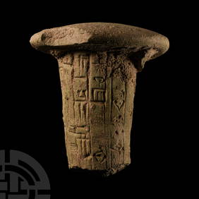
Mesopotamian Terracotta Foundation Nail for Ningirsu, the Strong Hero of Enlil his King, GudeaTimeLine Auctions Ltd.4.6(183)See Sold PriceMar 05, 2024
Mesopotamian Terracotta Foundation Nail for Ningirsu, the Strong Hero of Enlil His King, GudeaTimeLine Auctions Ltd.4.6(183)See Sold PriceMar 05, 2024
Johann Homann Hand-Colored Map Engraving, c. 1730Auctions at Showplace4.6(740)See Sold PriceMar 17, 2024
Willem Blaeu, Etc. 17th C. Antiquarian Maps, 2Auctions at Showplace4.6(740)See Sold PriceMar 17, 2024
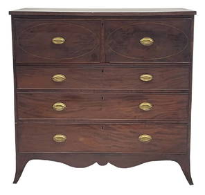
HEPPLEWHITE BUTLER'S DESK ATTRIB. MICHAEL ALLISON NEW YORK, C. 1810 (45 1/2" X 45 3/4" X 22")Carlsen Gallery, Inc.4.6(164)See Sold PriceMar 03, 2024
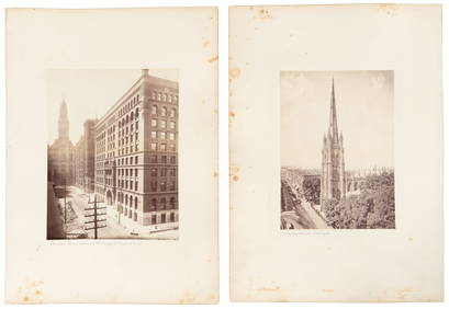
Helen Levitt (American, 1913-2009) New York, c. 1940Freeman's | Hindman4.4(1.6k)See Sold PriceMar 07, 2024
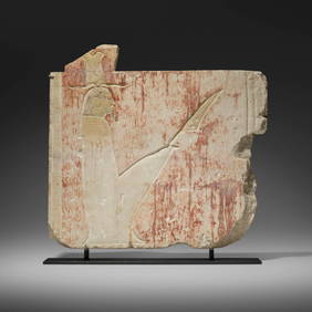
Egyptian, Architectural fragment, 26th DynastyToomey & Co. Auctioneers4.7(392)See Sold PriceFeb 29, 2024
A RARE EARLY AMERICAN STERLING SILVER BAAL SHEM TOV STYLE HANUKKAH LAMP. New York, c.1900. On fourJ. Greenstein & Co., Inc.4.2(55)See Sold PriceApr 16, 2024
A RARE AND IMPORTANT STERLING SILVER WEDDING RING BY MOSHE ZABARI. New York, c.1970.J. Greenstein & Co., Inc.4.2(55)See Sold PriceApr 16, 2024


![[Maps and Atlases] Large Lot Eighteenth and Nineteenth (1 of 3)](https://p1.liveauctioneers.com/928/93171/47564391_1_x.jpg?height=282&quality=70&version=1472660174)