ATLAS of ANTIENT GEOGRAPHY by SAMUEL BUTLER 1843John McInnis Auctioneers,LLC4.6(504)See Sold PriceFeb 24, 2024
18TH C. ANTIQUE MAP: FRENCH & INDIAN WAR, FRAMEDThomaston Place Auction Galleries4.4(389)See Sold PriceFeb 24, 2024
Rand McNally Railroad Map Cabinet w/ 21 Railroad MapsRail & Road Auctions4.6(165)See Sold PriceMar 08, 2024
Keith Haring - Ink on New York Map, Best Buddies, Inscribed, Signed, and DatedSapphire Auction Gallery4.1(67)See Sold PriceMar 02, 2024
LATE 17TH C. FRENCH MAP OF THE NEW WORLD BY ALEXIS-HUBERT JAILLOT (1632-1712)Thomaston Place Auction Galleries4.4(389)See Sold PriceFeb 24, 2024
Central Railroad of New Jersey Map of Sandy Hook Route-ca. 1903JM Hobby Supply and Railroad Artifact Auctions4.4(126)See Sold PriceFeb 24, 2024
Lot of Six Mixed Atlas Box Cars-HO Scale-New in BoxJM Hobby Supply and Railroad Artifact Auctions4.4(126)See Sold PriceFeb 25, 2024
Rand McNally/Santa Fe Railroad Map of Iowa-1912JM Hobby Supply and Railroad Artifact Auctions4.4(126)See Sold PriceFeb 24, 2024
NICOLAES VISSCHER (NETHERLANDS, 1618-1709) MAP OF THE NEW WORLDThomaston Place Auction Galleries4.4(389)See Sold PriceFeb 24, 2024
17TH C. WORLD MAP BY NICOLAES VISSCHER (NETHERLANDS, 1618-1709)Thomaston Place Auction Galleries4.4(389)See Sold PriceFeb 24, 2024
Lot of Six Mixed Atlas Cabooses-HO Scale-New in BoxJM Hobby Supply and Railroad Artifact Auctions4.4(126)See Sold PriceFeb 25, 2024
Sold17TH C MAP OF NEW NETHERLANDS - Novi Belgii Novaeque17TH C MAP OF NEW NETHERLANDS - Novi Belgii Novaeque Angliae: nec non partis Virginiae tabula multis in locis emendata. Amsterdam. Andreas Visscher, 1656. Engraving on laid paper, later hand coloring.See Sold Price
Sold17th c. Map of Ireland17th c. Map of Ireland by William Hole- ''Hiberniae Anglis, Yuerdon Britannis Erin incolis, Ierna, London, later hand-coloring, paper age toned. 11 x 13 1/2''See Sold Price
SoldJohn Speed 17th C Map Europe And The Chief CitiesJohn Speed (English, c.1551–1629). A hand colored 17th century map of Europe titled EUROP, AND THE CHIEFE CITIES, featuring description on verso. Measures 16 in. x 21 in. (sight), 20 1/2 in. x 25 1/See Sold Price
Sold17th C. Map of Guernsey, Jersey Islandsframed, not examined out of frame. Frame size: 18" high, 21 3/4" wide. Stains, toning. Provenance: Property of a Madison, CT Collector. Provenance: Purchased at New Haven Colony Historical Society AucSee Sold Price
Sold17TH C, MAP OF NEW ENGLAND, WILLEM BLAEU. FRAMEDWillem Blaeu (Dutch, 1751-1638). "Nova Belgica et Anglia Nova (Map of New Belgium and New England)" -1638, hand colored engraving. Elaborately framed. Approx. 28.5" X 33" (frame), 15.5" x 20" (sight)See Sold Price
Sold17TH C. MAP OF AMERICAS NICOLAUM VISSCHER(1618-1679):17th century map of Americas by Nicolaum Visscher. Also known as: Nicolaes Visscher Among the many great Dutch map publishers active in the seventeenth century were the Visscher family, begun by ClaesSee Sold Price
Sold17th c. Map17th c. map of Great Britain, "LE ROYAUME D' ANGLETERRE...". Loose in frame and not glued down. Sight 32" x 23 1/2". Marked and dated "A Paris chez H. Laillot 1693".See Sold Price
Sold17TH C. MAP OF SURREYHand-colored engraving with center fold. Dimensions: (Frame) H 22.5" x W 27", (Sight) H 15" x W 19.5" Condition: Mat heavily age toned. Frame with rubbing. Paper with age toning. Unexamined out of fraSee Sold Price
Sold17th c. Map of Jerusalem by Juan Baptista Villalpando17th c. Map of Jerusalem Entitled VERA HIEROSOLYMAE VETERIS IMAGO [True Picture of Old Jerusalem] byJuan Baptista Villalpando (1552-1608) | Map is engraved by Nicolas Sanson, Albavillaeo, Jan Goeree |See Sold Price
Sold17TH C, MAP OF BERMUDA, WILLEM BLAEU, FRAMEDWillem Blaeu (Dutch, 1751-1638). "Bermuda (Mappa Aestivarum Insularum Alias Barmudas)", -1630. Hand colored engraving. Elaborately framed. Approx. 28.75" x 33.75" (frame), 15.75" x 20.75" (sight)See Sold Price
Sold17th C. Map of New Netherlands - Nicholas Visscher"Novi Belgii Novaeque Angliae Nec Non partis Virginiae Tabula"--1656, hand colored engraved map, second state. Antique map depicting early view of America (or New Netherlands) with one of the first deSee Sold Price
Sold17th C. Map, INDIAE ORIENTALIS, Abraham OrteliusOriginal double folio hand colored map titled, "INDIAE ORIENTALIS INSULARUMQVE ADIACIENTI UM TYPUS" in stylized cartouche. Map printed circa 1587, Amsterdam, from atlas, "Theatrum Orbis Terrarum", theSee Sold Price
SoldFantastic Dutch 17th C. map of Japan & adjacent islandsA nice Dutch map of Japan and adjacent islands by Joan Jansson, c. 1660. Title: New and Accurate Japan, Land of Ezo and Adjacent Islands, fully hand-colored with 2 Compass Roses, 4 Galleons and a SeaSee Sold Price
Sold17TH C. MAP, ASIAE NOVA DESCRIPTIOc. 1600, Abraham Ortelius 14.5 by 19 in. (image), matted, framed under glass Prov.: Daphne Farago collectionSee Sold Price
Sold17TH C. MAP OF GERMANY TYPUS FRISIAE ORIENTALISDimensions: (Frame) H 19.5" x W 23.75" (Sight) H 15" x W 19.5" Condition: Holes to map. Discoloration and stains to paper. Wear to frame.See Sold Price
SoldGrp: 16th and 17th c. Maps of the World Hondius MLarge lot of 16th and 17th century maps of various parts of the world, many pages from books and atlases. By cartographers including Jodocus Hondius (1563-1612) and Herman Moll (ca. 1654-1732). SeveraSee Sold Price
Sold(2) 17TH C. MAPS OF HOLLANDBoth hand colored engravings, specific areas of Holland Dimensions: (largest open) H 20.5" x W 24" Condition: Some edge damages, losses, small spots of stainingSee Sold Price
Sold17THC. MAP OF NORTH AMERICACARTOGRAPHER UNKNOWN, POSS. JAN JANSSON 21 1/2" X 18 1/4"See Sold Price
SoldEARLY 17THC. MAP OF VIRGINIA DERIVATIVE 5(1630 - 1633) PUBLISHED BY HENRICUS HONDIUSSee Sold Price
Sold17th c HAND COLORED MAP OF RUGENAntique 17th c. Map Rugia Insula ac Ducatus. Highly decorative map of the island of Rugen. Embellished with a title-cartouches, and 30 coats-of-arms in the borders. From the French edition of Willem BSee Sold Price
Sold17th C Handcolored Map of TartariaA latter 17th c map of Tartaria, nicely handcolored. Text on verso. Measures 9 x 7". Fine condition. Reserve: $40.00 Shipping: Domestic: Flat-rate of $5.00 to anywhere within the contiguous U.S. InterSee Sold Price
SoldVintage Italian World Globe Dry Bar with Fitted Interior for Bar WareVintage Italian World Globe Dry Bar Featuring a World Globe on Stand with 17th C. Map with Astrologicial Signs and Metal Compass on Bottom Shelf, Interior is Fitted with Compartments to Hold All Bar WSee Sold Price
SoldJohn Speed 17th C Colored Map, Somerset ShireJohn Speed 17th C Colored Engraved Map, Somerset Shire, Englandwith coats of arms.Sudbury & Humble EditionDated: 1610, lower right.Dimensions: 20 1/4" x 15 1/4"Condition: Printed on hand made paper. VSee Sold Price
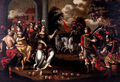
17TH C. ENGLISH CIVIL WAR HISTORY PAINTINGThomaston Place Auction Galleries4.4(389)See Sold PriceFeb 24, 2024
LARGE LATE 17TH C. DUTCH CHART OF CANADA, GREAT LAKES, NEW FRANCE, LABRADOR, HUDSON BAY, BY PIERREThomaston Place Auction Galleries4.4(389)See Sold PriceFeb 24, 2024
17TH C. WORLD MAP BY NICOLAES VISSCHER (NETHERLANDS, 1618-1709)Thomaston Place Auction Galleries4.4(389)See Sold PriceFeb 24, 2024
LATE 17TH C. FRENCH MAP OF THE NEW WORLD BY ALEXIS-HUBERT JAILLOT (1632-1712)Thomaston Place Auction Galleries4.4(389)See Sold PriceFeb 24, 2024
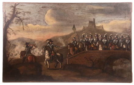
17TH C. ANTIQUE MAP SIEGE OF LA ROCHELLE, FRANCE, FRAMEDThomaston Place Auction Galleries4.4(389)See Sold PriceFeb 24, 2024
EARLY 18TH C. MAP OF ITALY, FRAMEDThomaston Place Auction Galleries4.4(389)See Sold PriceFeb 24, 2024
LATE 16TH C. MAP OF SCOTLAND BY MERCATOR, FRAMEDThomaston Place Auction Galleries4.4(389)See Sold PriceFeb 24, 2024
17TH C. MAP OF THE BERKSHIRES BY JOHN SPEED, FRAMEDThomaston Place Auction Galleries4.4(389)See Sold PriceFeb 24, 2024
17TH C. ENGLISH LINEAR MAP BY OGILBY, FRAMEDThomaston Place Auction Galleries4.4(389)See Sold PriceFeb 24, 2024
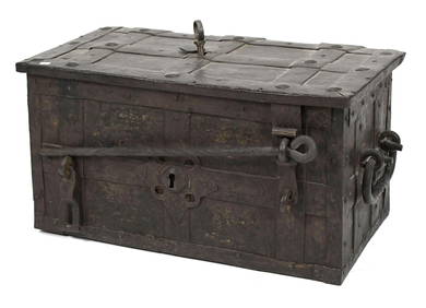
Antique 17th C English Geometric Oak Chest of DrawersKavanagh Auctions4.6(307)See Sold PriceFeb 24, 2024
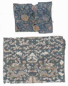
2 Antique Chinese Textile Fragments, 17th C. and 19th C.Material Culture4.6(769)See Sold PriceFeb 29, 2024
Willem Blaeu, Etc. 17th C. Antiquarian Maps, 2Auctions at Showplace4.6(731)See Sold PriceMar 17, 2024
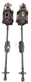
PAIR OF 17th C. STYLE VENETIAN WALL MOUNT LANTERNSLewis & Maese Antiques & Auction4.4(524)See Sold PriceFeb 25, 2024
Map: A 17thC engraved and hand coloured map of Scotland titled Strath-Navernia / Strath Navern afterClaydon Auctioneers Ltd4.3(125)See Sold PriceFeb 26, 2024
Map: A 17thC engraved map of the British Isles titled A Generall Mapp of the Isles of GreatClaydon Auctioneers Ltd4.3(125)See Sold PriceFeb 26, 2024
Map: A 17thC engraved and hand coloured map of Bedfordshire after Robert Morden. Approx. 12 1/2" xClaydon Auctioneers Ltd4.3(125)See Sold PriceFeb 26, 2024
Map: A 17thC engraved and hand coloured map after Frederik de Wit (1630-1706) titled Nova Persiae,Claydon Auctioneers Ltd4.3(125)See Sold PriceFeb 26, 2024
1675: ANTIQUE ILLUSTRATED JULIUS CAESAR MAPS OF ROMAN HISTORYNY Elizabeth 4.3(85)See Sold PriceMar 03, 2024