Sold17th C. Map of New Netherlands - Nicholas Visscher"Novi Belgii Novaeque Angliae Nec Non partis Virginiae Tabula"--1656, hand colored engraved map, second state. Antique map depicting early view of America (or New Netherlands) with one of the first deSee Sold Price
Sold17TH C MAP OF NEW NETHERLANDS - Novi Belgii Novaeque17TH C MAP OF NEW NETHERLANDS - Novi Belgii Novaeque Angliae: nec non partis Virginiae tabula multis in locis emendata. Amsterdam. Andreas Visscher, 1656. Engraving on laid paper, later hand coloring.See Sold Price
SoldNicholas Visscher Map "Novi Belgii"Nicholas Visscher Map "Novi Belgii", early Dutch map of New Netherlands, from the Jansson-Visscher series of maps, etching on laid paper with hand coloring, state unknown, 18-1/4" x 21-1/2" image, fraSee Sold Price
SoldRare 17th Century Map of theNortheast, New York [Novi Belgii Novaeque Angliae Nec Non partis Virginiae Tabula...], by Nicholas Visscher, Amsterdam, second edition, circa 1656, detailed map of New York, New Jersey, and PennsylvanSee Sold Price
Sold17TH C, MAP OF NEW ENGLAND, WILLEM BLAEU. FRAMEDWillem Blaeu (Dutch, 1751-1638). "Nova Belgica et Anglia Nova (Map of New Belgium and New England)" -1638, hand colored engraving. Elaborately framed. Approx. 28.5" X 33" (frame), 15.5" x 20" (sight)See Sold Price
Visscher. New World Map, 17th CenturyGiclee On Canvas - Visscher. New World Map, 17th CenturySee Sold Price
Visscher. New World Map, 17th CenturyArt Print on Canvas - Visscher. New World Map, 17th CenturySee Sold Price
SoldLate 17th. cen. gilt framed coloured map by NicholasLate 17th. cen. gilt framed coloured map by Nicholas Visscher- Magnae Britannia(British Isles).See Sold Price
Sold19thc Map of New Netherland, 17thc Dutch Colony1879 bookplate print, wood engraving, map of New Netherland ( 17thc Dutch Colony ) after an original 1656 map of A. Vanderdonck. 6" X 9 1/2" page size. 4 1/4" X 7" map size. New Netherland was comSee Sold Price
Sold17th C. Map of Guernsey, Jersey Islandsframed, not examined out of frame. Frame size: 18" high, 21 3/4" wide. Stains, toning. Provenance: Property of a Madison, CT Collector. Provenance: Purchased at New Haven Colony Historical Society AucSee Sold Price
Sold17TH C. MAP OF AMERICAS NICOLAUM VISSCHER(1618-1679):17th century map of Americas by Nicolaum Visscher. Also known as: Nicolaes Visscher Among the many great Dutch map publishers active in the seventeenth century were the Visscher family, begun by ClaesSee Sold Price
SoldFantastic Dutch 17th C. map of Japan & adjacent islandsA nice Dutch map of Japan and adjacent islands by Joan Jansson, c. 1660. Title: New and Accurate Japan, Land of Ezo and Adjacent Islands, fully hand-colored with 2 Compass Roses, 4 Galleons and a SeaSee Sold Price
SoldBLAEU ENGRAVING MAP OF THE NETHERLANDS, 17TH C.Unframed map, engraving on paper, "Frisia Occidentalis," cartographers Adriano Metius and Gerardo Freitag, published by Willem Blaeu (Dutch, 1571-1638), reverse with text, sheet: approx 19.75"h, 23"wSee Sold Price
Sold17th C. MapMap, "Archiducatus Austriae Superioris Geographica Descriptio," dated 1667. Provenance: From a New York collection.See Sold Price
Sold17TH C. MAP OF MEXICO CITY, DE BRY, LA AMERICAc. 1610, a bird's eye view of Mexico City, New Spain, engraved by de Bry published by Braun and Hogenberg (1572-1624) with German text grass cloth mat, framed under glass, 16.5 by 11.5 in. The fourthSee Sold Price
SoldAntique 1930s Folding 6' Screen 17thC Map o MadridAntique 1930s Dividing 6' Screen 17th Century Map of Madrid Fine 1930s room dividing screen was purchased from world-renowned luxury goods department store Bergdorf Goodman in New York City. Art DecoSee Sold Price
SoldVisscher. Tabula Nova Provinciae Ultrajectinae…[Netherlands] Nicholas Visscher. Tabula Nova Provinciae Ultrajectinae… Shows the road network of the Netherlands, ca. late 1600s - early 1700s. Cities shown include Haarlem, Gouda, Schoonhoven, BureSee Sold Price
SoldGrp: 10 Maps of New York City 18th-Early 20th c.Group of 18th to early 20th century maps of New York City. Multiple are 19th-20th c. reprints of 17th-18th c. maps. Includes a small census map of New York City from 1850 with populations of New YorkSee Sold Price
SoldLot of 2 framed mapsNovi Begii map of New England & Map of the Worls by Nicholas Visscher. 24"h x 27"w framed.See Sold Price
SoldILLUMINATIONS, ETC.Two, together with pastel on paper signed Augusta and a reproduction 17th/18th c. New York City map (all framed); Largest: 18 1/2" x 1 3/4" (irregular) (sheet)See Sold Price
SoldMap in tray from J. Pierpont Morgan yacht "CorsaiWell preserved example of Nicholas Visscher's world map from his late 17th century atlas, hand colored plate. Shows the signs of the zodiac along with cherubs and heavenly figures. California is shownSee Sold Price
Double hemisphere world map by Jan van Jagen 1741After “Orbis Terrarum Tabula Recens Emendata et in Lucem Edita per N. Visscher” world map by Nicholas Visscher (The Netherlands, 1618-1679), published in a Dutch Bible, 1663. Double hemispSee Sold Price
SoldN. SANSON MAP MEXICO, NEW MEXICO, CALIFORNIA ISLEFramed hand-colored map, "Audience de Guadalajara Nouveau Mexique, Californie, &c.," Nicolas Sanson (French, 1600-1667), 17th c., covers western Mexico and the American Southwest, showing California aSee Sold Price
SoldAntique large A New Map of XVII Provinces of LowAntique large A New Map of XVII Provinces of Low Germanic. By J. Speed. Copper plate engraving. Circa 17th C. Measures 17" tall x 21" wide. Was originally purchased at Jonathan Potter., LTD, London. BSee Sold Price
LARGE LATE 17TH C. DUTCH CHART OF CANADA, GREAT LAKES, NEW FRANCE, LABRADOR, HUDSON BAY, BY PIERREThomaston Place Auction Galleries4.4(393)See Sold PriceFeb 24, 2024
17TH C. WORLD MAP BY NICOLAES VISSCHER (NETHERLANDS, 1618-1709)Thomaston Place Auction Galleries4.4(393)See Sold PriceFeb 24, 2024
LATE 17TH C. FRENCH MAP OF THE NEW WORLD BY ALEXIS-HUBERT JAILLOT (1632-1712)Thomaston Place Auction Galleries4.4(393)See Sold PriceFeb 24, 2024
17TH C. ANTIQUE MAP SIEGE OF LA ROCHELLE, FRANCE, FRAMEDThomaston Place Auction Galleries4.4(393)See Sold PriceFeb 24, 2024
17TH C. MAP OF THE BERKSHIRES BY JOHN SPEED, FRAMEDThomaston Place Auction Galleries4.4(393)See Sold PriceFeb 24, 2024
17TH C. ENGLISH LINEAR MAP BY OGILBY, FRAMEDThomaston Place Auction Galleries4.4(393)See Sold PriceFeb 24, 2024
NICOLAES VISSCHER (NETHERLANDS, 1618-1709) MAP OF THE NEW WORLDThomaston Place Auction Galleries4.4(393)See Sold PriceFeb 24, 2024
17th Century Hand Colored Engraved Map of GermanyGlobal Auctions Company4.3(36)See Sold PriceMar 03, 2024
HAMMOND'S READY REFERENCE HISTORICAL ATLAS 1920North American Artifact Auctions4.7(198)See Sold PriceApr 20, 2024
Johann Homann Hand-Colored Map Engraving, c. 1730Auctions at Showplace4.6(740)See Sold PriceMar 17, 2024
Willem Blaeu, Etc. 17th C. Antiquarian Maps, 2Auctions at Showplace4.6(740)See Sold PriceMar 17, 2024
D'Entrecasteaux - Map of Australia (New Holland), New Zealand, and southern Asia and surroundingTrillium Antique Prints & Rare Books4.5(32)See Sold PriceFeb 24, 2024
Map: A 19thC engraved and hand coloured map of Buckingham titled A New Map of BuckinghamshireClaydon Auctioneers Ltd4.3(125)See Sold PriceFeb 26, 2024
1732 BIBLE BIBLIA NEERLANDICA antique OLD & NEW TESTAMENT NETHERLANDS DUTCHJasper524.5(9.9k)See Sold PriceFeb 27, 2024
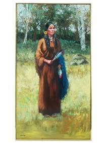
NATIVE AMERICAN PAINTING BY FRANK CARDOZO NICHOLASAntique Arena Inc.4.5(878)See Sold PriceMar 02, 2024
1750 Bowen Map of Bermuda and St. Kitts -- A New & Accurate Map of Bermudas or Sommer's Islands...Jasper524.5(9.9k)See Sold PriceFeb 27, 2024
Jan Goeree (1670-1731) - Set of 2 Italian Engravings of Roman ScenesProverde Auctions4.3(3)See Sold PriceFeb 28, 2024
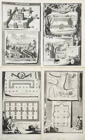
Jan Goeree (1670-1731) - Set av 4 Architecture Engravings - Church of Saint Pudentiana - AProverde Auctions4.3(3)See Sold PriceFeb 28, 2024
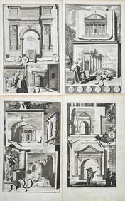
Jan Goeree (1670-1731) - Set av 4 Architecture Engravings - A Reconstruction of the Arch of DomitianProverde Auctions4.3(3)See Sold PriceFeb 28, 2024