ATLAS of ANTIENT GEOGRAPHY by SAMUEL BUTLER 1843John McInnis Auctioneers,LLC4.5(505)See Sold PriceFeb 24, 2024
18TH C. ANTIQUE MAP: FRENCH & INDIAN WAR, FRAMEDThomaston Place Auction Galleries4.4(393)See Sold PriceFeb 24, 2024
Rand McNally Railroad Map Cabinet w/ 21 Railroad MapsRail & Road Auctions4.6(165)See Sold PriceMar 08, 2024
Keith Haring - Ink on New York Map, Best Buddies, Inscribed, Signed, and DatedSapphire Auction Gallery4(67)See Sold PriceMar 02, 2024
LATE 17TH C. FRENCH MAP OF THE NEW WORLD BY ALEXIS-HUBERT JAILLOT (1632-1712)Thomaston Place Auction Galleries4.4(393)See Sold PriceFeb 24, 2024
Central Railroad of New Jersey Map of Sandy Hook Route-ca. 1903JM Hobby Supply and Railroad Artifact Auctions4.4(127)See Sold PriceFeb 24, 2024
Lot of Six Mixed Atlas Box Cars-HO Scale-New in BoxJM Hobby Supply and Railroad Artifact Auctions4.4(127)See Sold PriceFeb 25, 2024
Rand McNally/Santa Fe Railroad Map of Iowa-1912JM Hobby Supply and Railroad Artifact Auctions4.4(127)See Sold PriceFeb 24, 2024
NICOLAES VISSCHER (NETHERLANDS, 1618-1709) MAP OF THE NEW WORLDThomaston Place Auction Galleries4.4(393)See Sold PriceFeb 24, 2024
17TH C. WORLD MAP BY NICOLAES VISSCHER (NETHERLANDS, 1618-1709)Thomaston Place Auction Galleries4.4(393)See Sold PriceFeb 24, 2024
Lot of Six Mixed Atlas Cabooses-HO Scale-New in BoxJM Hobby Supply and Railroad Artifact Auctions4.4(127)See Sold PriceFeb 25, 2024
Sold17TH C, MAP OF NEW ENGLAND, WILLEM BLAEU. FRAMEDWillem Blaeu (Dutch, 1751-1638). "Nova Belgica et Anglia Nova (Map of New Belgium and New England)" -1638, hand colored engraving. Elaborately framed. Approx. 28.5" X 33" (frame), 15.5" x 20" (sight)See Sold Price
Sold17TH C, MAP OF BERMUDA, WILLEM BLAEU, FRAMEDWillem Blaeu (Dutch, 1751-1638). "Bermuda (Mappa Aestivarum Insularum Alias Barmudas)", -1630. Hand colored engraving. Elaborately framed. Approx. 28.75" x 33.75" (frame), 15.75" x 20.75" (sight)See Sold Price
c. 1650 Map - NY & New England“Upside Down” Map of New York and New England! c. 1650, [NEW YORK & NEW ENGLAND]: “NOVA BELGICA ET ANGLIA NOVA,” by Willem Blaeu, Amsterdam, Fine. 15.25” x 20” handSee Sold Price
SoldFramed Colored Engraved 17th C. World Map"Nova Totius Terrarum Sive Novi Orbis Tabula" Framed Colored Engraved 17th C. World Map by Willem Janszoon Blaeu - This interesting piece is an early world map created by Willem Janszoon Blaeu. The maSee Sold Price
SoldBleau Map of New EnglandBLAEU, Willem (1571-1638) & Blaeu, Joan (1596-1673). Nova Belgica et Anglia Nova. Engraved map with hand color. Amsterdam: 1635-1667). 20" x 23 1/2" sheet, 29" x 33" framed. This important map, firstSee Sold Price
SoldBlaeu 17th C Hand Colored Straits of Magellan Map17th Century hand colored map of the Straits of Magellan, framed under glass, bearing the arms of D. Constantino Hugenio and the signature of Guiljelmus (Willem) Blaeu but published by his son JohanneSee Sold Price
SoldWILLEM JANSZOON BLAEU 17TH/18TH C MAP OF BERMUDAWillem Janszoon Blaeu late 17th/early 18th century hand colored map of Bermuda. Titled "Mappa Aestivarum Insularum Alias Barmudas". Framed and matted in a burled wood finish frame. Condition: good conSee Sold Price
Sold[MAP OF BERMUDA] BLAEU, WILLEM (c. 1630)Mappa Aestivarum Insularum, alias Barmudas..., engraved bi-fold map with hand-coloring, showing the coasts of Florida, Viginia, Cape Cod, and New England, based on Speed's map, with latin text on versSee Sold Price
Map of Scotland – c.17th Century ‘Scotia Regnum'...Map of Scotland – c.17th Century ‘Scotia Regnum' Blaeu (Johan and Willem) with decorative cartouche to bottom right, coat of Arms and sailing ships, hand coloured, framed 59x48cm approx. measuresSee Sold Price
Two Maps of England, Shropshire andGloucester to Coventry Comitatus Salopiensis Anglice Shrop Shire, after Willem Blaeu, mid-17th century, engraving with later color, with coat of arms, 6 x 20-1?2 in. (sight), framed in a carved wood fSee Sold Price
Sold[MAP] BLAEU, WILLEM Tabula Magellanica quae Tierr[MAP] BLAEU, WILLEM Tabula Magellanica quae Tierrae del Fuego Engraved map, outlines colored by hand. 22 1/2 x 27 1/4 inches. Framed. [Amsterdam: 17th century]See Sold Price
SoldWillem Blaeu 17th C. Map of FranceAuthor: Willem Blaeu Hand Colored Published in Amsterdam c.1635. "Les Souverainetez de Sedan et de Raucourt, et la Prevoste de Doncheri."See Sold Price
Sold17thC Map: Framed Kingdom of England map, featuring17thC Map: Framed Kingdom of England map, featuring part of Ireland, part of Scotland, German Ocean. £40 - 60See Sold Price
MAP - New England & Mid-Atlantic US. BlaeuColonial New England & Mid-Atlantic United States. Willem Blaeu, Nova Belgica et Anglia Nova, 1643 (circa). Hand Color. This important map, first issued in 1635, is one of the first to focus on the DuSee Sold Price
SoldMAP OF NEW ENGLAND'Nova Belgica et Anglia Nova', by Willem Blaeu (1571-1663), hand-colored engraving, after a manuscript map by Adriaen Block, see Burden 241: 'First printed map that depicts canoes and North American fSee Sold Price
Barchinona Map by Willem Janszoon Blaeu 17th C.Barchinona Map Engraving by Willem Janszoon Blaeu (Dutch Cartographer) 17th C. Image size: 15 x 19 inches.See Sold Price
ANTIQUE 17TH C MAP CASTILIA W. BLAEUAntique map of Castilia by W. Blaeu. Title: Utriusquae Castiliae Nova Descriptio. By: Willem Jansz. (also written Guilielmus Janssonius) -- Willem Janszoon Blaeu. Date of the first edition/map first pSee Sold Price
SoldAntique Copy of Willem Blaeu World Map,Antique Copy of Willem Blaeu World Map, 19th c. reprint of 17th c. original, paper watermarked by French manufacturer Anson & Montgolfier. Appears to be hand-colored, but not examined out of frame. DOSee Sold Price
Sold18th C. Hand-Colored Map of New EnglandAn 18th C. hand-colored engraved map of New England, Nova Scotia, New France, or Canada, with the Islands of Newfoundland, Cape Breton, St. John's, by Jacques-Nicholas Bellin. Framed under glass. MatSee Sold Price
SoldWillem Blaeu Map, "Hiberina Regnum Vulgo Ireland",Willem Blaeu Map, "Hiberina Regnum Vulgo Ireland", Amsterdam, c. 1650, a magnificent example of 17th c. Dutch cartography showing the Emerald Isle divided into counties and having English place names,See Sold Price
SoldBLAEU, WILLEM. Nova Belgica et Anglia Nova.BLAEU, WILLEM. Nova Belgica et Anglia Nova. Double-page engraved map of New England oriented with north to the right. 18½x23 inches sheet size, wide margins, Latin text on verso; hand-colored inSee Sold Price
Blaeu Map of New EnglandBLAEU, Willem (1571-1638).Nova Belgica et Anglia Nova.Engraved map with original hand color in outline.Amsterdam, 1622 (1635 or later).19 1/4" x 23 1/2" sheet.This important map was one of the most atSee Sold Price
SoldBleau Map of New EnglandBlaeu, Willem (1571-1638). Nova Belgica et Anglia Nova. Engraved map with hand color in part. Amsterdam, 1635 or later. 18" x 22 1/4" sheet.See Sold Price
Sold17THC. BLAEU'S MAP OF MIDDLESEX COUNTY INC. LONDON ONINC. LONDON ON THE THAMES LOWER LEFT, WILLEM JANSZOON BLAEU 1571 - 1638 (15 1/2' X 16 1/4" PLATE SIZE)See Sold Price
LATE 18TH C. VERY LARGE CHART OF NORTHEAST CANADA BY DES BARRES (1721-1824), 1780, FRAMEDThomaston Place Auction Galleries4.4(393)See Sold PriceFeb 24, 2024
LARGE LATE 17TH C. DUTCH CHART OF CANADA, GREAT LAKES, NEW FRANCE, LABRADOR, HUDSON BAY, BY PIERREThomaston Place Auction Galleries4.4(393)See Sold PriceFeb 24, 2024
17TH C. WORLD MAP BY NICOLAES VISSCHER (NETHERLANDS, 1618-1709)Thomaston Place Auction Galleries4.4(393)See Sold PriceFeb 24, 2024
LATE 17TH C. FRENCH MAP OF THE NEW WORLD BY ALEXIS-HUBERT JAILLOT (1632-1712)Thomaston Place Auction Galleries4.4(393)See Sold PriceFeb 24, 2024
17TH C. ANTIQUE MAP SIEGE OF LA ROCHELLE, FRANCE, FRAMEDThomaston Place Auction Galleries4.4(393)See Sold PriceFeb 24, 2024
17TH C. MAP OF THE BERKSHIRES BY JOHN SPEED, FRAMEDThomaston Place Auction Galleries4.4(393)See Sold PriceFeb 24, 2024
17TH C. ENGLISH LINEAR MAP BY OGILBY, FRAMEDThomaston Place Auction Galleries4.4(393)See Sold PriceFeb 24, 2024
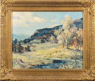
CLAUDE EDMOND DELBOS (1878-1949) Engraving Meadow Landscape ca1929Luis Porretta Fine Arts4.3(10)See Sold PriceMar 02, 2024
CLAUDE EDMOND DELBOS (1879-1949) Engraving Tree LandscapeLuis Porretta Fine Arts4.3(10)See Sold PriceMar 02, 2024
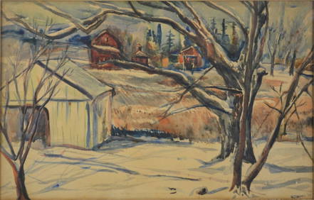
J Francis Murphy W/C New England Landscape PaintingHeritage Gallery Auctions4.4(60)See Sold PriceMar 10, 2024
17th Century Hand Colored Engraved Map of GermanyGlobal Auctions Company4.3(36)See Sold PriceMar 03, 2024
Willem Blaeu, Etc. 17th C. Antiquarian Maps, 2Auctions at Showplace4.6(740)See Sold PriceMar 17, 2024
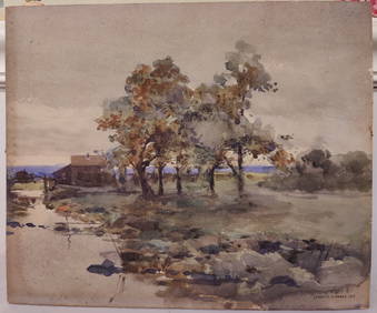
American Impressionist Original Oil Painting The Creek in Spring, framed c. 1950'sJasper524.5(9.9k)See Sold PriceFeb 28, 2024
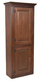
18TH C. NEW ENGLAND RED STAINED CHIMNEY CUPBOARD.William Smith Auctions4.6(147)See Sold PriceMar 06, 2024


![[MAP OF BERMUDA] BLAEU, WILLEM (c. 1630) (1 of 9)](https://p1.liveauctioneers.com/522/152734/77123885_1_x.jpg?height=282&quality=70&version=1571345617)


![[MAP] BLAEU, WILLEM Tabula Magellanica quae Tierr (1 of 1)](https://p1.liveauctioneers.com/292/9439/1956190_1_x.jpg?height=282&quality=70)