ATLAS of ANTIENT GEOGRAPHY by SAMUEL BUTLER 1843John McInnis Auctioneers,LLC4.5(505)See Sold PriceFeb 24, 2024
18TH C. ANTIQUE MAP: FRENCH & INDIAN WAR, FRAMEDThomaston Place Auction Galleries4.4(394)See Sold PriceFeb 24, 2024
Rand McNally Railroad Map Cabinet w/ 21 Railroad MapsRail & Road Auctions4.6(165)See Sold PriceMar 08, 2024
Keith Haring - Ink on New York Map, Best Buddies, Inscribed, Signed, and DatedSapphire Auction Gallery4.1(67)See Sold PriceMar 02, 2024
LATE 17TH C. FRENCH MAP OF THE NEW WORLD BY ALEXIS-HUBERT JAILLOT (1632-1712)Thomaston Place Auction Galleries4.4(394)See Sold PriceFeb 24, 2024
Central Railroad of New Jersey Map of Sandy Hook Route-ca. 1903JM Hobby Supply and Railroad Artifact Auctions4.4(127)See Sold PriceFeb 24, 2024
Lot of Six Mixed Atlas Box Cars-HO Scale-New in BoxJM Hobby Supply and Railroad Artifact Auctions4.4(127)See Sold PriceFeb 25, 2024
Rand McNally/Santa Fe Railroad Map of Iowa-1912JM Hobby Supply and Railroad Artifact Auctions4.4(127)See Sold PriceFeb 24, 2024
NICOLAES VISSCHER (NETHERLANDS, 1618-1709) MAP OF THE NEW WORLDThomaston Place Auction Galleries4.4(394)See Sold PriceFeb 24, 2024
17TH C. WORLD MAP BY NICOLAES VISSCHER (NETHERLANDS, 1618-1709)Thomaston Place Auction Galleries4.4(394)See Sold PriceFeb 24, 2024
Lot of Six Mixed Atlas Cabooses-HO Scale-New in BoxJM Hobby Supply and Railroad Artifact Auctions4.4(127)See Sold PriceFeb 25, 2024
Alexis Hubert Jaillot - Map, 1692.Alexis Hubert Jaillot - L'Asie Divisee en ses Principales Map, 1692. Map of Asia. 57x87cm.See Sold Price
SoldAlexis Hubert Jaillot (French 1632-1712) - Map of Asia,Alexis Hubert Jaillot (French 1632-1712) - Map of Asia, 1692. L'Asie Divisee en ses Principales Map, 1692. Map of Asia. 57x87cm. Folds, tears.See Sold Price
SoldAmerique Septentrionale divisee en ses principales...Amerique Septentrionale divisee en ses principales parties...Alexis-Hubert Jaillot (1632-1712). Amsterdam, c. 1692. Engraved map with original hand color in part. 24 x 36 inches sheet, 29 x 41 inchesSee Sold Price
Striking Map of Africa by Mortier of Jaillot's 1674L'Afrique Divisee suivant l'estndue des ses principales parties... Alexis-Hubert Jaillot (1632-1712). Engraved map with original hand color. Amsterdam: P. Mortier, 1692. 24 1/2 x 38 1/4 inches sheet,See Sold Price
SoldL'Afrique divisee suivant l'estendue de ses...L’Afrique divisee suivant l’estendue de ses principales parties… Alexis-Hubert Jaillot after Sanson. engraved map with original hand-color in full. Paris: H. Jaillot, 1692. 24 1/2 x 38 1/4 incheSee Sold Price
[Map] Jaillot, Charles Hubert Alexis. La Comte de[Map] Jaillot, Charles Hubert Alexis. La Comte de Bourgogne, our La Franche Comte, divisee en trois grand balliages… Paris, 1692. Engraved map with original hand-coloring in outline and later hand-cSee Sold Price
La Comte de Bourgogne, our La Franche Comte, divisee en[Map] Jaillot, Charles Hubert Alexis. La Comte de Bourgogne, our La Franche Comte, divisee en trois grand balliages… Paris, 1692. Engraved map with original hand-coloring in outline and later hand-cSee Sold Price
SoldMap, Alexis Hubert (Jailloteau) JaillotAlexis Hubert (Jailloteau) Jaillot (French, 1632-1712), "La Scandinavie et les Environs, ou sont Les Royaumes Des Suede De Danemarck et De Norwege...," 1692, hand-colored copper engraved map, image: 1See Sold Price
Sold1692 Le Comte De Zeelande MapUnframed c. 1692 steel engraved & colored 24 1/4" x 36 1/4" double folio map, "Le Comte De Zeelande" by Alexis Hubert Jaillot, depicting the Province of Zeeland in the Netherlands.See Sold Price
Soldmap, Jaillot, Asia, Middle East, AfricaUnframed handcolored engraved map, ''L'Asie distinguee en ses Principales Regions,'' (1692), by Alexis-Hubert Jaillot (French, 1632-1712), plate: 22.5''h x 34.5''w, overall: 24.5''h x 37.5''w. Note: MSee Sold Price
SoldSanson (Nicolas) & Jaillot (Alexis Hubert) L’AsieSanson (Nicolas) & Jaillot (Alexis Hubert) L’Asie divisée en ses principales parties…, engraved map, hand coloured, title cartouche, central vertical fold, 63 x 98cm, Paris, 1692. ***Based upon tSee Sold Price
AFTER ALEXIS-HUBERT JAILLOT, MAP OF SOUTH AMERICAAfter Alexis-Hubert Jaillot (French 1632-1712), "Amerique Meridionale Divisée En Ses Principales Parties Ou Sont Distingués Les Vns Des Autres Les Estats Suivant Qu'ils Appartieñent PresentemSee Sold Price
Alexis Hubert Jaillot (1632-1712): Map of Holy LandAlexis Hubert Jaillot: Map of Holy Land, engraving, map showing Ancient Palestine, Judea and the Holy Land from “Atlas Nouveau,” published by Jaillot in Paris, 1696, edited by Pierre Mortier. AlexSee Sold Price
Alexis-Hubert JAILLOT Wall map. JAILLOT. L’Asie,JAILLOT, Alexis-Hubert. L’Asie, divisée selon l’étendue de ses principales parties…Paris, Jaillot et Desnos, 1782 6 fogli uniti, complessivamente 1.230x1.145 mm. Carta muraSee Sold Price
SoldAlexis Hubert Jaillot (French 1632-1712) map of Asia,Alexis Hubert Jaillot (French 1632-1712) map of Asia, "L' Asie, Distinquee en ses principales Parties. 1687", framed and glazed, "L'asie divisee en ses Principales Regions, et ousepeut voir l'estendueSee Sold Price
SoldAFTER ALEXIS HUBERT JAILLOT (FRENCH, 1632-1712) MAP OFAFTER ALEXIS HUBERT JAILLOT (FRENCH, 1632-1712) MAP OF SOUTHERN ITALY AND THE MEDITERRANEAN, hand-colored engraving on paper, titled "Le Royaume De Naples Divise en Douze Provinces". Retains old hand-See Sold Price
SoldHubert Jaillot Sanson 1692 Map of ItalyFrame: 38" x 26" image sight: 36.25" x 24.25"See Sold Price
SoldALEXIS HUBERT JAILLOT, HAND COLORED ENGRAVED MAPALEXIS HUBERT JAILLOT, HAND COLORED ENGRAVED MAP, LES ISLES BRITANNIQUES, WITH INSET OF THE ORKNEYS AND SHETLAND ISLES, AMSTERDAM C.1705, 2-SHEETS JOINED. SIGHT 23 1/2 X 36"; FRAMED AND GLAZED-32 X 44See Sold Price
SoldMap, Jaillot, Le Cours Du Danube... 1693Map, Alexis Hubert Jaillot (1632-1712), Le Cours du Danube Depuis sa Source Jusqu'a ses Embouchures Dresse sur les Memoires lesplus Nouveau du P.Coronelli et autres..., circa 1693, Paris, a large andSee Sold Price
SoldCarte Particuliere de Virginie, Maryland, Pennsilvanie,Alexis-Hubert Jaillot (1632-1712). Engraved Map with orginal hand coloring in outline. Amsterdam and Paris: Pierre Mortier, c.1693-1710. 24 7/8 x 38 inches, 29 5/8 x 42 5/8 inches framed. An importantSee Sold Price
SoldLarge-scale world map in two hemispheres prepared by N.Mappe-Monde Geo-Hydrographique...Alexis-Hubert Jaillot (1632-1712). Engraved map with original hand color. Amsterdam: P. Mortier, 1691. 24 1/2 x 38 1/4 inches sheet, 35 1/2 x 49 1/2 inches framed. LarSee Sold Price
Jaillot Map of Eastern CanadaPartie de la Nouvelle France. Alexis Hubert Jaillot (1632-1712). Engraved map with hand color in outline. Paris, 1685 (first state). 20 x 27 inches sheet. Map of Canada by the French cartographer, focSee Sold Price
Jaillot Engraved Map of France Post RevolutionCarte des Postes de France pour L'Annee 1786...Alexis-Hubert Jaillot (1632-1712). Engraved map with very fine color. Paris, 1786. 25 1/2 x 31 inches sheet. The Best Map of France before the RevolutionSee Sold Price
French Map of the America's by JaillotAmerique Meridionale divisee en ses Principales Parties...Alexis-Hubert Jaillot (1632-1712). Engraved map with original hand color. Amsterdam: P. Mortier, 1691. 24 1/2 x 38 1/4 inches sheet, 35 1/2 xSee Sold Price
LARGE LATE 17TH C. DUTCH CHART OF CANADA, GREAT LAKES, NEW FRANCE, LABRADOR, HUDSON BAY, BY PIERREThomaston Place Auction Galleries4.4(394)See Sold PriceFeb 24, 2024
LATE 17TH C. FRENCH MAP OF THE NEW WORLD BY ALEXIS-HUBERT JAILLOT (1632-1712)Thomaston Place Auction Galleries4.4(394)See Sold PriceFeb 24, 2024
18TH C. ANTIQUE MAP: FRENCH & INDIAN WAR, FRAMEDThomaston Place Auction Galleries4.4(394)See Sold PriceFeb 24, 2024
Keith Haring - Ink on New York Map, Best Buddies, Inscribed, Signed, and DatedSapphire Auction Gallery4.1(67)See Sold PriceMar 02, 2024
Rand McNally Railroad Map Cabinet w/ 21 Railroad MapsRail & Road Auctions4.6(165)See Sold PriceMar 08, 2024
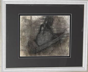
Alexis Leyva Machado Kcho (Born 1970) Cuban Framed Mixed media on paper, signed.Basel Auction House4.5(48)See Sold PriceFeb 24, 2024
Hubert Hilscher CYRK Tiger Cat Polish Circus 1971 PosterBasel Auction House4.5(48)See Sold PriceFeb 24, 2024
Putnam - First Map of the State of Ohio by Rufus PutnamTrillium Antique Prints & Rare Books4.5(33)See Sold PriceFeb 24, 2024
Goltzius - 6 Etchings of Portraits of Holy Roman EmperorsTrillium Antique Prints & Rare Books4.5(33)See Sold PriceFeb 24, 2024
Hubert Kornelisz (1689 - 1733) - Set of 2 Allegorical Copperplate Engravings, NetherlandsProverde Auctions4.3(3)See Sold PriceFeb 28, 2024
Hubert Kornelisz (1689 - 1733) - Set of 2 Allegorical Copperplate Engravings, NetherlandsProverde Auctions4.3(3)See Sold PriceFeb 28, 2024


![[Map] Jaillot, Charles Hubert Alexis. La Comte de (1 of 1)](https://p1.liveauctioneers.com/928/104923/53749646_1_x.jpg?height=282&quality=70&version=1496865216)