ATLAS of ANTIENT GEOGRAPHY by SAMUEL BUTLER 1843John McInnis Auctioneers,LLC4.6(502)See Sold PriceFeb 24, 2024
18TH C. ANTIQUE MAP: FRENCH & INDIAN WAR, FRAMEDThomaston Place Auction Galleries4.4(386)See Sold PriceFeb 24, 2024
Rand McNally Railroad Map Cabinet w/ 21 Railroad MapsRail & Road Auctions4.6(165)See Sold PriceMar 08, 2024
Keith Haring - Ink on New York Map, Best Buddies, Inscribed, Signed, and DatedSapphire Auction Gallery4(67)See Sold PriceMar 02, 2024
LATE 17TH C. FRENCH MAP OF THE NEW WORLD BY ALEXIS-HUBERT JAILLOT (1632-1712)Thomaston Place Auction Galleries4.4(386)See Sold PriceFeb 24, 2024
Central Railroad of New Jersey Map of Sandy Hook Route-ca. 1903JM Hobby Supply and Railroad Artifact Auctions4.4(126)See Sold PriceFeb 24, 2024
Lot of Six Mixed Atlas Box Cars-HO Scale-New in BoxJM Hobby Supply and Railroad Artifact Auctions4.4(126)See Sold PriceFeb 25, 2024
Rand McNally/Santa Fe Railroad Map of Iowa-1912JM Hobby Supply and Railroad Artifact Auctions4.4(126)See Sold PriceFeb 24, 2024
NICOLAES VISSCHER (NETHERLANDS, 1618-1709) MAP OF THE NEW WORLDThomaston Place Auction Galleries4.4(386)See Sold PriceFeb 24, 2024
17TH C. WORLD MAP BY NICOLAES VISSCHER (NETHERLANDS, 1618-1709)Thomaston Place Auction Galleries4.4(386)See Sold PriceFeb 24, 2024
Lot of Six Mixed Atlas Cabooses-HO Scale-New in BoxJM Hobby Supply and Railroad Artifact Auctions4.4(126)See Sold PriceFeb 25, 2024
Smith (Charles) - Smith's Map of England & Walesengraved map", with hand-colouring, on two sheets joined, 795 x 625mm., dissected and backed on linen, light spotting and browning, minor surface dirt, in contemporary cloth covered slipcase, with oriSee Sold Price
SoldEngland & Wales.- Smith (Charles) Smith's New Map ofEngland & Wales.- Smith (Charles) Smith's New Map of the Inland Navigation of England & Wales, with details of the inland waterways, or rivers and canals, of England and Wales, engraving with originalSee Sold Price
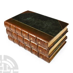
SoldSmith (Charles) - Smith's New English Atlas,first edition, bound as a folded-over travelling atlas, ornately lettered engraved title, 45 of 46 maps, including general map of England and Wales, Yorkshire on 4 sheets and Wales on 2 sheets, but laSee Sold Price
Smith (Charles) New English AtlasSmith (Charles) New English Atlas, engraved title, 25 engraved maps (of 42), including general map of England and Wales, and Yorkshire on 4 sheets, with original hand-colouring, the majority dSee Sold Price
SoldBritish Isles.- Smith & Son (Charles) A GeologicalBritish Isles.- Smith & Son (Charles) A Geological Railway & Canal Map of England, Wales and part of Scotland, inset map of 'Canals and Railways around Birmingham' in the lower right corner, alongsideSee Sold Price
SoldSmith (Chalres) - Smith's Map of England & Walesengraved map, with hand-colouring, on two sheets joined, 795 x 625mm., dissected and backed on linen, light spotting and browning, minor surface dirt, in contemporary cloth covered slipcase, with origSee Sold Price
Smith's Map of England & Wales, 1834Title: Smith's Map of England & Wales, Containing the Whole of the Turnpike Roads, Rivers & Canals with the Distance from London to every Principal Town, and from one Market Town to Another Author: SmSee Sold Price
SoldGeology.- Phillips (John) Memoirs of William Smith,Geology.- Phillips (John) Memoirs of William Smith, LL.D., Author of "Map of the Strata of England and Wales", first edition, 5 engraved or lithographed portraits (1 as frontipsiece), illustrations, 8See Sold Price
SoldJOHN SMITH'S MAP OF NEW ENGLAND"NEW ENGLAND The most remarqueable parts thus named by the high and might Prince CHARLES, Prince of Great Britaine", colored engraving, made by John Smith, engraved by Simon Passaeus, and printed by JSee Sold Price
SoldMARY SMITH, 1794 NEEDLEWORK MAPMARY SMITH, 1794 NEEDLEWORK MAP, silk on linen, "A MAP OF ENGLAND AND WALES", lower edge inscribed "Mary Smith / November 19 / 1794", all within an undulating flower and vine border. Period, possiblySee Sold Price
SoldSmith (Harry Worcester)Smith (Harry Worcester) A Sporting Tour through Ireland, England, Wales and France, in the Years 1912-1913, 2 vol., the author's proof copy, presentation copy to the bookseller Charles SessleSee Sold Price
SoldSmith (Harry Worcester)Smith (Harry Worcester) A Sporting Tour through Ireland, England, Wales and France, in the Years 1912-1913, The Bookplate Edition, 2 vol., bookplate signed by the author, plates and maps, someSee Sold Price
SoldSMITH, JOHN. New England the most remarqueableSMITH, JOHN. New England the most remarqueable parts thus named by the high and mighty Prince Charles, Prince of great Britaine. Engraved folding map, 300x345, ample margins; very minor separations alSee Sold Price
SoldCharles Smith mapCharles Smith map- ''Poland''- hand0colored engraving, 1808, from 'Smith's New General Atlas Containing Distinct Maps of All the Principal Empires, Kingdoms and States throughout the World...''- paperSee Sold Price
SoldSmith (Charles) Smith's New Map of London and StreSmith (Charles) Smith's New Map of London and Street Indicator,from Islington to Kennington Oval, and from Commercial and Surrey Docks to Hyde Park, with indicator tape on original brass mountSee Sold Price
SoldLondon.- Smith & Sons (Charles) Smith's Indicator MapNO RESERVE London.- Smith & Sons (C.) Smith's Indicator Map of London, showing from Hyde Park to Mile End, including Regents Park and part of Victoria Park with the City of London highlighted in red,See Sold Price
SoldSmith (Charles) Map Twelve Miles Round LondonSmith (Charles) Map of the Country Twelve Miles Round London,extending from Hadley to Addington, and from Northolt to Hornchurch, engraved folding map, dissected and linen-backed, with originaSee Sold Price
Sold[Costume. England] Smith, Charles Hamilton. The Ancient[Costume. England] Smith, Charles Hamilton. The Ancient Costume of Great Britain and Ireland. From the Seventh to the Sixteenth Century. London: Colnaghi, 1815. Hand-colored engraved title page and 60See Sold Price
SoldLondon.- Smith (Charles) Map of the Country TwelveLondon.- Smith (Charles) Map of the Country Twelve Miles Round London, showing from Ewell to Enfield, and from Southall to Hornchurch in the east, engraved map by W.R. Gardner, with early hand-colouriSee Sold Price
SoldSmith (Charles) Map of CumberlandSmith (Charles) A New Map of the County of Cumberland,engraved map with original outline hand-colouring, 495 x 440mm., central horizontal fold, slightly discoloured, 1808 Cary (John) A Map oSee Sold Price
SoldSmith (Charles) Map of the Country Twelve Miles RoSmith (Charles) Map of the Country Twelve Miles Round London,1st edition, from Enfield to Ewell and from Dartford to Southall, engraved map by W.R. Gardner, with original hand-colouring, 745 xSee Sold Price
Smith (Charles) Map of the Country Twelve Miles RoSmith (Charles) Map of the Country Twelve Miles Round London,1st edition, from Enfield to Ewell and from Dartford to Southall, engraved map by W.R. Gardner, with original hand-colouring, 745 xSee Sold Price
London.- Smith (Charles) Reynolds's Map of London withNO RESERVE London.- Smith (Charles, publisher) Reynolds's Map of London with the recent Improvements, lithographed map printed in colours, 605 x 880 mm. (23 3/4 x 34 3/4 in), dissected and mounted onSee Sold Price
SoldCHARLES SMITH (ENGLISH, 1768-1854) MAP OF THE WORLDCHARLES SMITH (ENGLISH, 1768-1854) MAP OF THE WORLD, hand-colored, depicting the Western and Eastern hemispheres, title centered above "The / WORLD / Engraved for Smith's Atlas", and centered below "PSee Sold Price
Archaeological Books - Roach Smith & Fairholt - The Antiquities of Richborough, Reculver, and Lymne,TimeLine Auctions Ltd.4.5(183)See Sold PriceMar 06, 2024
Archaeological Books - Roach Smith - Collectanea Antiqua, etchings and notices of ancient remains,TimeLine Auctions Ltd.4.5(183)See Sold PriceMar 06, 2024
Archaeological Books - Roach Smith - Catalogue of the Museum of London AntiquitiesTimeLine Auctions Ltd.4.5(183)See Sold PriceMar 06, 2024
Numismatic Books - Boyne - Tokens Issued in the Seventeenth Century in England, Wales, and IrelandTimeLine Auctions Ltd.4.5(183)See Sold PriceMar 09, 2024
1950's Charles and Alice Smith Chalice California pottery tiki face vase. Vase has alternatingNeely Auction4.6(224)See Sold PriceFeb 25, 2024
Charles L. A. Smith California 1871-1937 Watercolor painting Landscape near LAGlobal Auctions Company4.3(36)See Sold PriceMar 03, 2024
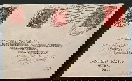
1935 Darwin Australia Experimental flight Cover To England Charles Smith Only 49Mynt Auctions4.6(680)See Sold PriceFeb 24, 2024
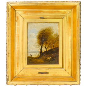
Attrib. Jean Baptiste Camille Corot (French, 1796-1875) Oil on Canvas PaintingAkiba Galleries4.7(1.7k)See Sold PriceFeb 29, 2024
Late 18th century map of England and Wales sampler and two printsFellows4.3(159)See Sold PriceMar 05, 2024
Dr. Charles Smith (American/Louisiana, b. 1940)Neal Auction Company4.6(348)See Sold PriceMar 14, 2024


![[Costume. England] Smith, Charles Hamilton. The Ancient (1 of 4)](https://p1.liveauctioneers.com/928/104923/53749536_1_x.jpg?height=282&quality=70&version=1496865216)