ATLAS of ANTIENT GEOGRAPHY by SAMUEL BUTLER 1843John McInnis Auctioneers,LLC4.6(502)See Sold PriceFeb 24, 2024
18TH C. ANTIQUE MAP: FRENCH & INDIAN WAR, FRAMEDThomaston Place Auction Galleries4.4(386)See Sold PriceFeb 24, 2024
Rand McNally Railroad Map Cabinet w/ 21 Railroad MapsRail & Road Auctions4.6(165)See Sold PriceMar 08, 2024
Keith Haring - Ink on New York Map, Best Buddies, Inscribed, Signed, and DatedSapphire Auction Gallery4(67)See Sold PriceMar 02, 2024
LATE 17TH C. FRENCH MAP OF THE NEW WORLD BY ALEXIS-HUBERT JAILLOT (1632-1712)Thomaston Place Auction Galleries4.4(386)See Sold PriceFeb 24, 2024
Central Railroad of New Jersey Map of Sandy Hook Route-ca. 1903JM Hobby Supply and Railroad Artifact Auctions4.4(126)See Sold PriceFeb 24, 2024
Lot of Six Mixed Atlas Box Cars-HO Scale-New in BoxJM Hobby Supply and Railroad Artifact Auctions4.4(126)See Sold PriceFeb 25, 2024
Rand McNally/Santa Fe Railroad Map of Iowa-1912JM Hobby Supply and Railroad Artifact Auctions4.4(126)See Sold PriceFeb 24, 2024
NICOLAES VISSCHER (NETHERLANDS, 1618-1709) MAP OF THE NEW WORLDThomaston Place Auction Galleries4.4(386)See Sold PriceFeb 24, 2024
17TH C. WORLD MAP BY NICOLAES VISSCHER (NETHERLANDS, 1618-1709)Thomaston Place Auction Galleries4.4(386)See Sold PriceFeb 24, 2024
Lot of Six Mixed Atlas Cabooses-HO Scale-New in BoxJM Hobby Supply and Railroad Artifact Auctions4.4(126)See Sold PriceFeb 25, 2024
SoldHerman Moll map: CAROLINA shows NC, SC and FL[Southeast] Herman Moll. CAROLINA map. Shows North and South Carolina and Florida, including what is now Georgia, including their trans- Appalachian regions. The southern Tidewater region of VirginiaSee Sold Price
SoldMOLL. Map of Carolina.MAP - MOLL, Herman. Carolina.London: after 1729. Engraved map (200x275 mm plate mark size). Condition: chips and short tears in the margins outside the plate mark. Cartographically the sameSee Sold Price
SoldH. Moll: Rare Antique Map of Carolina, 1746Title/Content of Map: Carolina's Rare & important Map Date Printed: 1746 Cartographer: Thomas Salmon & Herman Moll Material/Medium: Paper Size: 14 1/2" x 8 1/2" Copperplate engraved. Published in LondSee Sold Price
Soldc. 1729, Map of CAROLINAMapsBold Early Colonial Printed Map of “Carolina” by H. Moll c. 1729, Map of “CAROLINA,” by Herman Moll, England, Choice Extremely Fine. Map measures 8” x 11”, withSee Sold Price
Sold4 Maps: Carolina + Carte de la Virginie + 2 others[East Coast]. 4 Maps. ++ Herman Moll. 2 maps on 1 sheet: Carolina./ A Map of ye Island of Bermudos Divided into its Tribes, wth. The Castles, Forts &c. (nd). "Appears in Atlas Geographicus London. NutSee Sold Price
SoldMoll, Carolina, 1729[Carolina]. H. Moll. Carolina. Engraved map, 1729. 7 7/8 x 10 3/4 in. Contemporary outline color. From Atlas Minor, 1729. Phillips (Atlases) 574-51. Very good condition.See Sold Price
SoldMoll, Herman. A Map of the Province of CarolinaMoll, Herman. A Map of the Province of Carolinacopperplate engraving with hand-color (London, 1730), depicting North and South Carolina extending from the Virginia line all the way to Florida, with anSee Sold Price
18th-Century Map of Carolina by Herman Moll, 18th-Century Map of Carolina by Herman Moll, hand-outlined, 9 x 12.75" (plate area approx. 8 x 10.5"), 1736. Atlas map publ. by Thos. Bowles and John Bowles. (see Rumsey Collection, Image 5580051; hSee Sold Price
SoldHermann Moll, ''Carolina,'' 1729.[United States: Southeast]. Hermann Moll. Carolina. Double-page engraved map showing North Carolina, South Carolina, and Georgia, extending to northern Florida and eastern portion of Ozarks. Dated 172See Sold Price
SoldHumphreys (D.) An Historical AccountHumphreys (David) An Historical Account of the Incorporated Society for the Propagation of the Gospel in Foreign Parts, first edition, 2 folding engraved maps by H.Moll, Carolina with short teSee Sold Price
SoldMoll map of Carolinia 1741Title: Carolina Author: Moll, Herman Description: 18x16 cm. (7x6½").Small, scarce map is derived from the important Gascoyne map of 1682, covering the coast from Cape Henry to B. St. Matheo with niceSee Sold Price
Moll's Map of EuropeAn early 18th century map of Europe "To Her most Sacred Majesty Carolina, Queen of Great Britain, France & Ireland". By Herman Moll, published 1708 by John Bowles. Hand colored engraving on paper. OveSee Sold Price
Sold18th Century Map of Carolina & BermudaMy Herman Moll. Very nicely detailed having some hand tinting. Full margins and not laid down. Good overall condition. Unframed. H7 1/2" W13 1/4"See Sold Price
SoldCarolina & Bermuda 1716Map Title: Carolina & The Island Bermudos Maker: Herman Moll Date: 1716 Origin: Atlas Geographicus Size: 13 x 16 inches Medium: Copperplate engraving Herman Moll (1654-1732) was a London cartographer,See Sold Price
SoldMap of Port Royal Harbour Carolina by Herman Moll 1730Map: Plan of Port Royal Harbour in Carolina Maker: Herman Moll Date: 1730-32 Size: 8 x 10.5 inches Hilton Head and Port Royal, South Carolina. Moll notes on the map that it is "the best Country in CarSee Sold Price
SoldMOLL, HERMAN. A Plan of Port Royal - Harbour iMOLL, HERMAN. A Plan of Port Royal - Harbour in Carolina. Engraved map, 210x280 mm, wide margins; hand-colored in outline. London, 1729 All items are offered for sale subject to Swann Galleries' stanSee Sold Price
Sold1 piece. Engraved Map with Outline Color. Moll, H1 piece. Engraved Map with Outline Color. Moll, H. Carolina." (London), 1729. 7 3/4 x 10 3/4 inches; 197 x 273 mm - image size. Central & western parts of map dampstained. Framed."See Sold Price
Herman Moll (Dutch, 1654-1732)CAROLINA/FLORIDA called by French Louisiana/NEW ENGLAND, NEW YORK, NEW JERSEY AND PENNSYLVANIAthree engraved maps with hand colored engraved map of the West Indies 8 1/2 x 11 inches.See Sold Price
Map of Port Royal Harbor, SouthCarolina "A. Plan of Port Royal Harbor in Carolina with the proposed forts, depth of water & latitude...", after Herman Moll, Dutch, 1654-1732, 42 original drafts by Herman Moll, published in London bSee Sold Price
Port Royal harbor in the Carolina’s. RARE colonial eraTitle: Port Royal harbor in the Carolina’s. RARE colonial era subject Date/Period: 1732/1736 Materials: Copper plate engraved Dimensions: 13 1/2 x 9” By. H. Moll. From. Atlas minor. Published, LonSee Sold Price
Sold1757 Map Carolina & GeorgiaCarte De La Caroline ET Georgie. Nicely hand tinted map having well defined plate lines and nicely framed. H9" W13"See Sold Price
SoldHerman Moll Map Virginia and Maryland 1741Herman Moll (ca. 1654-1732), "A New Map of Virginia and Maryland," London, 1741. Hand colored engraved map of the Chesapeake Bay region, showing what is now Virginia, Maryland, Delaware, and parts ofSee Sold Price
SoldMoll: Map of Poland, 1701Map of Poland. An original copperplate engraving published by Herman Moll in 1701. With text describing the Kingdom Of Poland. 7 x 7.5 " (map only) Please note that this lot has a reserve. When you leSee Sold Price
SoldHerman Moll Map of Africa ca. 1720Herman Moll (ca. 1654-1732). Map of Africa, London, ca. 1720. With an elaborate dedication cartouche reading "To the right honourable Charles, Earl of Peterborow and Monmouth, etc this map of Africa aSee Sold Price
3 North Carolina Art Pottery VasesSchmidt's Antiques Inc. Since 19114.8(431)See Sold PriceMar 02, 2024
18TH C. ANTIQUE MAP: FRENCH & INDIAN WAR, FRAMEDThomaston Place Auction Galleries4.4(386)See Sold PriceFeb 24, 2024
Keith Haring - Ink on New York Map, Best Buddies, Inscribed, Signed, and DatedSapphire Auction Gallery4(67)See Sold PriceMar 02, 2024
Rand McNally Railroad Map Cabinet w/ 21 Railroad MapsRail & Road Auctions4.6(165)See Sold PriceMar 08, 2024
Carey, pub. 1796 - Map of The State of South CarolinaTrillium Antique Prints & Rare Books4.5(30)See Sold PriceFeb 24, 2024
Carey, pub. 1796 - Map of the Tennassee State formerly part of North Carolina (Tennessee)Trillium Antique Prints & Rare Books4.5(30)See Sold PriceFeb 24, 2024
Wilson - Carolina Parrot & Flycatchers. 26Trillium Antique Prints & Rare Books4.5(30)See Sold PriceFeb 24, 2024
Catesby, Folio - Tumble-Turds (Dung Beetle) with Canada Lily. Sup-11Trillium Antique Prints & Rare Books4.5(30)See Sold PriceFeb 24, 2024
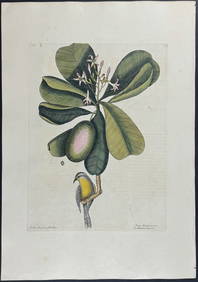
Catesby, Folio - American Goldfinch with Acacia. 1-43Trillium Antique Prints & Rare Books4.5(30)See Sold PriceFeb 24, 2024
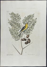
Catesby, Folio - Bahama Titmouse with Seven Years Apple. 1-59Trillium Antique Prints & Rare Books4.5(30)See Sold PriceFeb 24, 2024
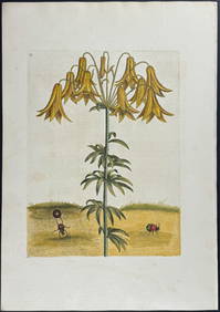
Catesby, Folio - American Partridge with Attamusco Lily. Sup-12Trillium Antique Prints & Rare Books4.5(30)See Sold PriceFeb 24, 2024
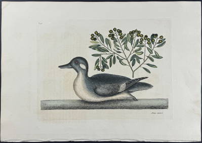
Catesby, Folio - Little Brown Duck with Soap-Wood. 1-98Trillium Antique Prints & Rare Books4.5(30)See Sold PriceFeb 24, 2024
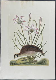
Catesby, Folio - Red Bellied Woodpecker & Hairy Woodpecker with Black Oak. 1-19Trillium Antique Prints & Rare Books4.5(30)See Sold PriceFeb 24, 2024
Herman Moll A New Map of Ye North Parts of AmericaWillow Auction House4.5(283)See Sold PriceMar 14, 2024


![[Tintype] Identified North Carolina Infantryman (1 of 2)](https://p1.liveauctioneers.com/7226/317626/170485474_1_x.jpg?height=282&quality=70&version=1706368022)