SoldHerman Moll map: CAROLINA shows NC, SC and FL[Southeast] Herman Moll. CAROLINA map. Shows North and South Carolina and Florida, including what is now Georgia, including their trans- Appalachian regions. The southern Tidewater region of VirginiaSee Sold Price
Sold(4) 1838 BRADFORD Maps: NC, SC, GA, FL.[United States/South] 4 Maps. ++ NORTH CAROLINA. ++ SOUTH CAROLINA. ++ GEORGIA. ++ FLORIDA. ++ +Maps 28, 30, 31, 32 from T. G. Bradford, “An Illustrated Atlas, Geographical, Statistical, And HistoriSee Sold Price
Sold4 Maps: Carolina + Carte de la Virginie + 2 others[East Coast]. 4 Maps. ++ Herman Moll. 2 maps on 1 sheet: Carolina./ A Map of ye Island of Bermudos Divided into its Tribes, wth. The Castles, Forts &c. (nd). "Appears in Atlas Geographicus London. NutSee Sold Price
SoldMOLL. Map of Carolina.MAP - MOLL, Herman. Carolina.London: after 1729. Engraved map (200x275 mm plate mark size). Condition: chips and short tears in the margins outside the plate mark. Cartographically the sameSee Sold Price
18th-Century Map of Carolina by Herman Moll, 18th-Century Map of Carolina by Herman Moll, hand-outlined, 9 x 12.75" (plate area approx. 8 x 10.5"), 1736. Atlas map publ. by Thos. Bowles and John Bowles. (see Rumsey Collection, Image 5580051; hSee Sold Price
Soldc. 1729, Map of CAROLINAMapsBold Early Colonial Printed Map of “Carolina” by H. Moll c. 1729, Map of “CAROLINA,” by Herman Moll, England, Choice Extremely Fine. Map measures 8” x 11”, withSee Sold Price
SoldMoll, Herman. A Map of the Province of CarolinaMoll, Herman. A Map of the Province of Carolinacopperplate engraving with hand-color (London, 1730), depicting North and South Carolina extending from the Virginia line all the way to Florida, with anSee Sold Price
SoldMitchell: Antique Map of Southern States, US, 1858MAP of SOUTHERN STATES & PART WESTERN U.S. NC SC GA FL AL TN LA AK MS. Circa 1858 Antique Map. No. 12 - MAP OF THE CHIEF PART OF THE SOUTHERN STATES AND PART OF THE WESTERN. Engraved to Illustrate MitSee Sold Price
MAP - Southern South America. MollSouthern South America. Herman Moll, Chili Magellans-Land and Terra del Fuego &c., 1701 (published). Hand Color. This detailed copper engraved map shows the southern tip of South America with Tierra dSee Sold Price
Sold18th Century Map of Carolina & BermudaMy Herman Moll. Very nicely detailed having some hand tinting. Full margins and not laid down. Good overall condition. Unframed. H7 1/2" W13 1/4"See Sold Price
SoldCarolina & Bermuda 1716Map Title: Carolina & The Island Bermudos Maker: Herman Moll Date: 1716 Origin: Atlas Geographicus Size: 13 x 16 inches Medium: Copperplate engraving Herman Moll (1654-1732) was a London cartographer,See Sold Price
Sold4 US MINT $25 BAGS OF STATE QUARTERS AL FL NC SC4 US Mint $25 bags of state quarters. Includes: South Carolina (D), North Carolina (D), Alabama (P, 2003), and Florida (P, 2004). All in bags, as issued.See Sold Price
4 US MINT $25 BAGS OF STATE QUARTERS AL FL NC SC4 US Mint $25 bags of state quarters. Includes: South Carolina (D), North Carolina (D), Alabama (P, 2003), and Florida (P, 2004). All in bags, as issued.See Sold Price
SoldH. Moll: Rare Antique Map of Carolina, 1746Title/Content of Map: Carolina's Rare & important Map Date Printed: 1746 Cartographer: Thomas Salmon & Herman Moll Material/Medium: Paper Size: 14 1/2" x 8 1/2" Copperplate engraved. Published in LondSee Sold Price
Sold1852 OLD ANTIQUE MAP SOUTHERN UNITED STATES, MITCHELL1852 OLD ANTIQUE MAP SOUTHERN UNITED STATES, MITCHELL FL GA SC NC TN MS AR LA AL 1852 Antique Map by S. Augustus Mitchell of Pennsylvania. ??No. 12 - MAP OF THE CHIEF PART OF THE SOUTHERN STATES AND PSee Sold Price
SoldMOLL, HERMAN. A Plan of Port Royal - Harbour iMOLL, HERMAN. A Plan of Port Royal - Harbour in Carolina. Engraved map, 210x280 mm, wide margins; hand-colored in outline. London, 1729 All items are offered for sale subject to Swann Galleries' stanSee Sold Price
SoldMap of Port Royal Harbour Carolina by Herman Moll 1730Map: Plan of Port Royal Harbour in Carolina Maker: Herman Moll Date: 1730-32 Size: 8 x 10.5 inches Hilton Head and Port Royal, South Carolina. Moll notes on the map that it is "the best Country in CarSee Sold Price
SoldA New and Exact Map of France Dividid HERMAN MOLLDetails: MOLL, Herman (fl. 1678-1732). A New and Exact Map of France Dividid [sic] into all its provinces and acquisitions, according to the newest observations, and that accurate survey made by theSee Sold Price
Sold1795 Map of VA, NC, SC, & GA1795 Map of the states of Virginia, North Carolina, South Carolina & Georgia by Joseph Purcell & Book by Jedidiah Morse, 12 1/4" x 15". Good condition.See Sold Price
SoldMoll map of Carolinia 1741Title: Carolina Author: Moll, Herman Description: 18x16 cm. (7x6½").Small, scarce map is derived from the important Gascoyne map of 1682, covering the coast from Cape Henry to B. St. Matheo with niceSee Sold Price
Herman Moll (Dutch, 1654-1732)CAROLINA/FLORIDA called by French Louisiana/NEW ENGLAND, NEW YORK, NEW JERSEY AND PENNSYLVANIAthree engraved maps with hand colored engraved map of the West Indies 8 1/2 x 11 inches.See Sold Price
Moll's Map of EuropeAn early 18th century map of Europe "To Her most Sacred Majesty Carolina, Queen of Great Britain, France & Ireland". By Herman Moll, published 1708 by John Bowles. Hand colored engraving on paper. OveSee Sold Price
Map of Port Royal Harbor, SouthCarolina "A. Plan of Port Royal Harbor in Carolina with the proposed forts, depth of water & latitude...", after Herman Moll, Dutch, 1654-1732, 42 original drafts by Herman Moll, published in London bSee Sold Price
SoldMoll NEW AND EXACT MAP OF THE DOMINIONS OF THE KING OFDetails: MOLL, Herman (fl. 1678-1732). A New and Exact Map of the Dominions of the King of Great Britain on ye continent of North America containing Newfoundland, New Scotland, New England, New York,See Sold Price
Crams Map of North Dakota-Complete Railroad System and County Map-1907JM Hobby Supply and Railroad Artifact Auctions4.4(126)See Sold PriceFeb 24, 2024
Crams Township and Railroad Map of Pennsylvania-1898JM Hobby Supply and Railroad Artifact Auctions4.4(126)See Sold PriceFeb 24, 2024
Kenyons Pocket Map and Shippers Guide of Wisconsin-1914JM Hobby Supply and Railroad Artifact Auctions4.4(126)See Sold PriceFeb 24, 2024
FLYING A TOURING SERVICE U.S. ROAD MAPS TIN WALL DISPLAY.Dan Morphy Auctions4.2(1.3k)See Sold PriceFeb 25, 2024
EARLY 18TH C. DUTCH CHART OF PACIFIC OCEAN BY FREDERIK DE WIT (1629-1706) WITH CALIFORNIA AS ANThomaston Place Auction Galleries4.4(386)See Sold PriceFeb 24, 2024
Jerusalem Map for British Soldiers in Palestine - WW2Levy Auction House4.3(11)See Sold PriceFeb 27, 2024
1853 Colton's Railroad & Township Map of Massachusetts, Rhode Island, and ConnecticutRail & Road Auctions4.6(165)See Sold PriceMar 07, 2024
1855 Map of New York & Erie Railroad and 1917 Trespassing On Railway Property Is A MisdemeanorRail & Road Auctions4.6(165)See Sold PriceMar 07, 2024
Four Lehigh & Hudson River Railway Annual Passes - 1896, 1897, 1898, and 1920Rail & Road Auctions4.6(165)See Sold PriceMar 08, 2024
1867 Map of the Railroads of The State of New YorkRail & Road Auctions4.6(165)See Sold PriceMar 08, 2024
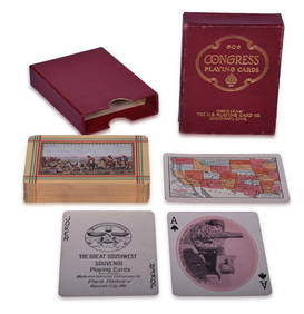
Fred Harvey Railroad Early Souvenir Playing Cards of the Great Southwest - Indians and Train SmokeRail & Road Auctions4.6(165)See Sold PriceMar 08, 2024
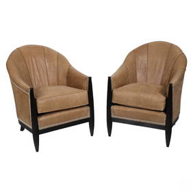
Swaim Designer Tooled Leather Club Side ArmchairsHill Auction Gallery 4.7(1k)See Sold PriceFeb 28, 2024
Carey, pub. 1796 - Map of The State of South CarolinaTrillium Antique Prints & Rare Books4.5(30)See Sold PriceFeb 24, 2024
Herman Moll A New Map of Ye North Parts of AmericaWillow Auction House4.5(283)See Sold PriceMar 14, 2024