ATLAS of ANTIENT GEOGRAPHY by SAMUEL BUTLER 1843John McInnis Auctioneers,LLC4.6(502)See Sold PriceFeb 24, 2024
18TH C. ANTIQUE MAP: FRENCH & INDIAN WAR, FRAMEDThomaston Place Auction Galleries4.4(386)See Sold PriceFeb 24, 2024
Rand McNally Railroad Map Cabinet w/ 21 Railroad MapsRail & Road Auctions4.6(165)See Sold PriceMar 08, 2024
Keith Haring - Ink on New York Map, Best Buddies, Inscribed, Signed, and DatedSapphire Auction Gallery4(67)See Sold PriceMar 02, 2024
LATE 17TH C. FRENCH MAP OF THE NEW WORLD BY ALEXIS-HUBERT JAILLOT (1632-1712)Thomaston Place Auction Galleries4.4(386)See Sold PriceFeb 24, 2024
Central Railroad of New Jersey Map of Sandy Hook Route-ca. 1903JM Hobby Supply and Railroad Artifact Auctions4.4(126)See Sold PriceFeb 24, 2024
Lot of Six Mixed Atlas Box Cars-HO Scale-New in BoxJM Hobby Supply and Railroad Artifact Auctions4.4(126)See Sold PriceFeb 25, 2024
Rand McNally/Santa Fe Railroad Map of Iowa-1912JM Hobby Supply and Railroad Artifact Auctions4.4(126)See Sold PriceFeb 24, 2024
NICOLAES VISSCHER (NETHERLANDS, 1618-1709) MAP OF THE NEW WORLDThomaston Place Auction Galleries4.4(386)See Sold PriceFeb 24, 2024
17TH C. WORLD MAP BY NICOLAES VISSCHER (NETHERLANDS, 1618-1709)Thomaston Place Auction Galleries4.4(386)See Sold PriceFeb 24, 2024
Lot of Six Mixed Atlas Cabooses-HO Scale-New in BoxJM Hobby Supply and Railroad Artifact Auctions4.4(126)See Sold PriceFeb 25, 2024
Sold1870 Mitchell map of Brazil and surrounding countriesHeading: (South America) Author: Mitchell, S. Augustus Title: Maps of Chili, Brazil, Boliva, Paraguay, Uruguay, including the Harbors of Bahia and Rio Janeiro Place Published: N.p. Publisher:N.p.See Sold Price
Rand McNally Map of AbyssiniaRand McNally (Fl. 1870-1920's). Map of Abyssinia and surrounding countries. Lithograhped map with hand color from Rand, McNally & Co's Indexed Atlas of the World. Chicago: Rand McNally, 1893. 21 3/4"See Sold Price
Mitchell: Antique Map of South American Countries, 1870Title/Content of Map: 1870 Mitchell Map of Venezuela, Columbia, Granada, Peru, Equador and part of Argentina -- Map of New Granada, Venezuela, Guiana, Peru, Equador and Argentine Confederation Date PrSee Sold Price
Sold2 Maps, S. Augustus Mitchell (ca. 1870)"Country Map of Nova Scotia, New Brunswick, Cape Breton Island & Prince Edward Island" and "Map of Quebec in Counties", S. Augustus Mitchell, lithograph, hand color (ca. 1870), unframed 11 1/2 x 15. GSee Sold Price
Sold1870 Mitchell Map of Virginia and West Virginia --Title/Content of Map: 1870 Mitchell Map of Virginia and West Virginia -- County Map of Virginia and West Virginia Date: 1870, Philadelphia Cartographer: S Mitchell Size: 11.9 x 14.6 in. This handsomeSee Sold Price
1870 Mitchell Map of New Hampshire and Vermont -- NewTitle/Content of Map: 1870 Mitchell Map of New Hampshire and Vermont -- New Hampshire and Vermont Date: 1870, Philadelphia Cartographer: S Mitchell Size: 13.6 x 11.4 in. This is a very nice map of NewSee Sold Price
1870 Mitchell Map Of Cincinnati1870 Mitchell Map Of Cincinnati -- Plan Of Cincinnati And Vicinity Map: S. A. Mitchell, 1870, Philadelphia, 10.5 x 11 in. Cincinnati's 20 wards identified by number for census, and detailed view of stSee Sold Price
Sold1870 Mitchell Map of North America -- Map of NorthTitle/Content of Map: 1870 Mitchell Map of North America -- Map of North America Showing Its Political Divisions and Recent Discoveries in the Polar regions Date Printed: 1870, Philadelphia CartographSee Sold Price
1870 Mitchell Map of Nevada and Utah -- County Map ofTitle: 1870 Mitchell Map of Nevada and Utah -- County Map of Utah and Nevada Date: 1870, Philadelphia Cartographer: S Mitchell Size: 11.5 X 13.8 in. Additional Information: Very nice map with good detSee Sold Price
1870 Mitchell Map of New Hampshire and Vermont -- NewTitle: 1870 Mitchell Map of New Hampshire and Vermont -- New Hampshire and Vermont Date: 1870, Philadelphia Cartographer: S Mitchell Size: 13.6 x 11.4 in. Additional Information: This is a very nice mSee Sold Price
1870 Mitchell Map of New Hampshire and Vermont -- NewTitle/Content of Map: 1870 Mitchell Map of New Hampshire and Vermont -- New Hampshire and Vermont Date: 1870, Philadelphia Cartographer: S Mitchell Size: 13.6 x 11.4 in. This is a very nice map of NewSee Sold Price
Sold1870 Mitchell Map of Minnesota -- County Map ofTitle/Content of Map: 1870 Mitchell Map of Minnesota -- County Map of Minnesota Date: 1870, Philadelphia Cartographer: S Mitchell Size: 13.8 x 11.5 in. This is nice county map of Minnesota. Great dealSee Sold Price
1870 Mitchell Map of New Hampshire and Vermont -- NewTitle/Content of Map: 1870 Mitchell Map of New Hampshire and Vermont -- New Hampshire and Vermont Date: 1870, Philadelphia Cartographer: S Mitchell Size: 13.6 x 11.4 in. This is a very nice map of NewSee Sold Price
Antique 1870 Mitchell Map of Nevada and UtahTitle/Content of Map: 1870 Mitchell Map of Nevada and Utah -- County Map of Utah and Nevada Date Printed: 1870, Philadelphia Cartographer: S Mitchell Size: 11.5 X 13.8 in. Very nice map with good detaSee Sold Price
Sold1870 Mitchell Map of Philadelphia -- Plan ofTitle: 1870 Mitchell Map of Philadelphia -- Plan of Philadelphia Cartographer: S Mitchell Year / Place: 1870, Philadelphia Map Dimension (in.): 11 X 13 in. This is an excellent map of Philadelphia. GrSee Sold Price
1870 Mitchell Map of New Hampshire and Vermont -- NewTitle/Content of Map: 1870 Mitchell Map of New Hampshire and Vermont -- New Hampshire and Vermont Date: 1870, Philadelphia Cartographer: S Mitchell Size: 13.6 x 11.4 in. This is a very nice map of NewSee Sold Price
1870 Mitchell Map of Arizona and New Mexico -- ArizonaReserve Reduced! Title/Content of Map: 1870 Mitchell Map of Arizona and New Mexico -- Arizona and New Mexico Date: 1870, Philadelphia Cartographer: S Mitchell Size: 10.6 X 13.5 in. Handsome county mapSee Sold Price
1870 Mitchell Map of Cincinnati -- Plan of CincinnatiTitle/Content of Map: 1870 Mitchell Map of Cincinnati -- Plan of Cincinnati and Vicinity Date: 1870, Philadelphia Cartographer: S. A. Mitchell Size: 10.5 x 11 Cincinnati's 20 wards identified by numbeSee Sold Price
1870 Mitchell Map of Arizona and New Mexico -- ArizonaTitle/Content of Map: 1870 Mitchell Map of Arizona and New Mexico -- Arizona and New Mexico Date: 1870, Philadelphia Cartographer: S Mitchell Size: 10.6 X 13.5 in. Handsome county map of Arizona and NSee Sold Price
1870 Mitchell Map of Arizona and New Mexico -- ArizonaTitle/Content of Map: 1870 Mitchell Map of Arizona and New Mexico -- Arizona and New Mexico Date: 1870, Philadelphia Cartographer: S Mitchell Size: 10.6 X 13.5 in. Handsome county map of Arizona and NSee Sold Price
1870 Mitchell Map of Nevada and Utah -- County Map ofTitle/Content of Map: 1870 Mitchell Map of Nevada and Utah -- County Map of Utah and Nevada Date Printed: 1870, Philadelphia Cartographer: S Mitchell Size: 11.5 X 13.8 in. Very nice map with good detaSee Sold Price
Antique 1870 Mitchell Map of North AmericaTitle/Content of Map: 1870 Mitchell Map of North America -- Map of North America Showing Its Political Divisions and Recent Discoveries in the Polar regions Date Printed: 1870, Philadelphia CartographSee Sold Price
1870 Mitchell Map of New Hampshire and Vermont -- NewTitle/Content of Map: 1870 Mitchell Map of New Hampshire and Vermont -- New Hampshire and Vermont Date: 1870, Philadelphia Cartographer: S Mitchell Size: 13.6 x 11.4 in. This is a very nice map of NewSee Sold Price
Sold1870 Mitchell Map of Oregon, Washington, Idaho andTitle/Content of Map: 1870 Mitchell Map of Oregon, Washington, Idaho and parts of Montana -- Map of Oregon, Washington, Idaho and part of Montana Date: 1870, Philadelphia Cartographer: S Mitchell SizeSee Sold Price
Pennsylvania Central/Pittsburgh Ft Wayne and Chicago 1870 Public TimetableJM Hobby Supply and Railroad Artifact Auctions4.4(126)See Sold PriceFeb 24, 2024
LARGE GULF SERVICE STATION MAP COLLECTION WITH DISPLAY STAND.Dan Morphy Auctions4.2(1.3k)See Sold PriceFeb 24, 2024
1849 Mitchell School ATLAS 24 MAPS America Holy Land France Africa Egypt AsiaSchilb Antiquarian Rare Books4.8(421)See Sold PriceMar 31, 2024
Cartier Santos de Watch MM Bezel Diamond W4SA0005 Silver UnisexBidhaus4.3(747)See Sold PriceFeb 25, 2024
1738 RUSSIA SIBERIA & GREAT TARTARY Description illustrated ANTIQUE in ENGLISHJasper524.5(9.8k)See Sold PriceFeb 27, 2024
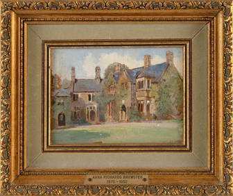
ANNA MARY RICHARDS BREWSTER (Massachusetts/New York, 1870-1952), "Country House, Near ExeterEldred's4.7(409)See Sold PriceMar 13, 2024
États du Roi de Maroc… d’Alger, Tunis & Tripoli. North Africa. BONNE 1790 mapJasper524.5(9.8k)See Sold PriceFeb 28, 2024
États du Roi de Maroc… d’Alger, Tunis & Tripoli. North Africa. BONNE 1788 mapJasper524.5(9.8k)See Sold PriceFeb 28, 2024
Two Hand-Colored 19th Century Maps of New Orleans and Louisiana, Larger- H.- 12 1/2 in., W.- 15 1/2Crescent City Auction Gallery4.3(229)See Sold PriceMar 08, 2024
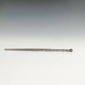
Antique South American Silver Judaica Torah PointerLion and Unicorn4.7(1.8k)See Sold PriceMar 14, 2024


![Vintage Airplane Desk Model [Air France] (1 of 7)](https://p1.liveauctioneers.com/5755/320282/172113951_1_x.jpg?height=282&quality=70&version=1708463029)