ATLAS of ANTIENT GEOGRAPHY by SAMUEL BUTLER 1843John McInnis Auctioneers,LLC4.6(502)See Sold PriceFeb 24, 2024
18TH C. ANTIQUE MAP: FRENCH & INDIAN WAR, FRAMEDThomaston Place Auction Galleries4.4(386)See Sold PriceFeb 24, 2024
Rand McNally Railroad Map Cabinet w/ 21 Railroad MapsRail & Road Auctions4.6(165)See Sold PriceMar 08, 2024
Keith Haring - Ink on New York Map, Best Buddies, Inscribed, Signed, and DatedSapphire Auction Gallery4(67)See Sold PriceMar 02, 2024
LATE 17TH C. FRENCH MAP OF THE NEW WORLD BY ALEXIS-HUBERT JAILLOT (1632-1712)Thomaston Place Auction Galleries4.4(386)See Sold PriceFeb 24, 2024
Central Railroad of New Jersey Map of Sandy Hook Route-ca. 1903JM Hobby Supply and Railroad Artifact Auctions4.4(126)See Sold PriceFeb 24, 2024
Lot of Six Mixed Atlas Box Cars-HO Scale-New in BoxJM Hobby Supply and Railroad Artifact Auctions4.4(126)See Sold PriceFeb 25, 2024
Rand McNally/Santa Fe Railroad Map of Iowa-1912JM Hobby Supply and Railroad Artifact Auctions4.4(126)See Sold PriceFeb 24, 2024
NICOLAES VISSCHER (NETHERLANDS, 1618-1709) MAP OF THE NEW WORLDThomaston Place Auction Galleries4.4(386)See Sold PriceFeb 24, 2024
17TH C. WORLD MAP BY NICOLAES VISSCHER (NETHERLANDS, 1618-1709)Thomaston Place Auction Galleries4.4(386)See Sold PriceFeb 24, 2024
Lot of Six Mixed Atlas Cabooses-HO Scale-New in BoxJM Hobby Supply and Railroad Artifact Auctions4.4(126)See Sold PriceFeb 25, 2024
1870 Mitchell Map of New Hampshire and Vermont -- NewTitle/Content of Map: 1870 Mitchell Map of New Hampshire and Vermont -- New Hampshire and Vermont Date: 1870, Philadelphia Cartographer: S Mitchell Size: 13.6 x 11.4 in. This is a very nice map of NewSee Sold Price
1870 Mitchell Map of New Hampshire and Vermont -- NewTitle: 1870 Mitchell Map of New Hampshire and Vermont -- New Hampshire and Vermont Date: 1870, Philadelphia Cartographer: S Mitchell Size: 13.6 x 11.4 in. Additional Information: This is a very nice mSee Sold Price
1870 Mitchell Map of New Hampshire and Vermont -- NewTitle/Content of Map: 1870 Mitchell Map of New Hampshire and Vermont -- New Hampshire and Vermont Date: 1870, Philadelphia Cartographer: S Mitchell Size: 13.6 x 11.4 in. This is a very nice map of NewSee Sold Price
1870 Mitchell Map of New Hampshire and Vermont -- NewTitle/Content of Map: 1870 Mitchell Map of New Hampshire and Vermont -- New Hampshire and Vermont Date: 1870, Philadelphia Cartographer: S Mitchell Size: 13.6 x 11.4 in. This is a very nice map of NewSee Sold Price
1870 Mitchell Map of New Hampshire and Vermont -- NewTitle/Content of Map: 1870 Mitchell Map of New Hampshire and Vermont -- New Hampshire and Vermont Date: 1870, Philadelphia Cartographer: S Mitchell Size: 13.6 x 11.4 in. This is a very nice map of NewSee Sold Price
1870 Mitchell Map of New Hampshire and Vermont -- NewTitle/Content of Map: 1870 Mitchell Map of New Hampshire and Vermont -- New Hampshire and Vermont Date: 1870, Philadelphia Cartographer: S Mitchell Size: 13.6 x 11.4 in. This is a very nice map of NewSee Sold Price
1870 Mitchell Map of New Hampshire and Vermont -- NewTitle/Content of Map: 1870 Mitchell Map of New Hampshire and Vermont -- New Hampshire and Vermont Date: 1870, Philadelphia Cartographer: S Mitchell Size: 13.6 x 11.4 in. This is a very nice map of NewSee Sold Price
1870 Mitchell Map of New Hampshire and Vermont -- NewTitle/Content of Map: 1870 Mitchell Map of New Hampshire and Vermont -- New Hampshire and Vermont Cartographer: S Mitchell Year/Place: 1870, Philadelphia Size: 13.6 x 11.4 in. This is a very nice mapSee Sold Price
1870 Mitchell Map of New Hampshire and Vermont -- NewTitle/Content of Map: 1870 Mitchell Map of New Hampshire and Vermont -- New Hampshire and Vermont Date: 1870, Philadelphia Cartographer: S Mitchell Size: 13.6 x 11.4 in. This is a very nice map of NewSee Sold Price
SoldMitchell: New Hampshire & Vermont, 1870Title/Content of Map: Mitchell: New Hampshire & Vermont, 1870 Date Printed: 1870, Philadelphia Cartographer: S. A. Mitchell Size: 11 3/8" x 13 3/4" The beautifully detailed and colored county map of NSee Sold Price
Mitchell: New Hampshire & Vermont, 1870The beautifully detailed and colored county map of New Hampshire and Vermont from the 1870 edition of Mitchell's popular New General Atlas of the world. The map is framed by the vine motif border typiSee Sold Price
Mitchell: New Hampshire & Vermont, 1870Map Title: New Hampshire and Vermont.Cartographer: S. A. Mitchell Place/Date: Philadelphia / 1870 Size: 11 3/8" x 13 3/4" Condition: full color; light overall age toning; some spotting in margins andSee Sold Price
Mitchell: New Hampshire & Vermont, 1870Map Title: New Hampshire and Vermont. Cartographer: S. A. Mitchell Place/Date: Philadelphia / 1870 Size: 11 3/8" x 13 3/4" Condition: full color; light overall age toning; some spotting in margins andSee Sold Price
Mitchell: Map of New Hampshire & Vermont, 1869Title/Content of Map: New Hampshire & Vermont by Mitchell Date Printed: 1869 Cartographer: Augustus S. Mitchell Size: 14" x 16" Material/Medium: Paper Provenance: New York Published in Philadelphia inSee Sold Price
Mitchell: Antique Map of New Hampshire & Vermont, 1869Title/Content of Map: New Hampshire & Vermont by Mitchell Date Printed: 1869 Cartographer: Augustus S. Mitchell Material/Medium: Paper Size: 12" x 15" Hand colored steel engraved Map. Published in PhiSee Sold Price
Mitchell: Antique Map of New Hampshire & Vermont, 1869Title/Content of Map: New Hampshire & Vermont by Mitchell Date Printed: 1869 Cartographer: Augustus S. Mitchell Material/Medium: Paper Size: 12" x 15" Hand colored engraved Map. From 'Mitchell's New GSee Sold Price
Samuel Lewis Map of New Hampshire, 1813.17 x 21 inches. Together with an 1867 S. Augustus Mitchell Jr. Map of New Hampshire and Vermont, 15 1/4 x 12 inches.See Sold Price
Sold1876 Mitchell Map of Vermont and New Hampshire --Title/Content of Map: 1876 Mitchell Map of Vermont and New Hampshire -- County and Township Map of New Hampshire and Vermont Date: 1876 Philadelphia Cartographer: S MitchellSize: 14.5 X 20.6 in. ThisSee Sold Price
SoldMitchell: New Hampshire & Vermont Map, 1877New Hampshire and Vermont, 15 x 22.75 in, 1877, S. Augustus Mitchell Please note that this lot has a confidential reserve. When you leave a bid in advance of the auction, submit your maximum. Jasper52See Sold Price
Samuel Augustus Mitchell (1790-1868), "County Map ofSamuel Augustus Mitchell (1790-1868), "County Map of New York, New Hampshire, Vermont, Massachusettes, Rhode Island and Connecticut," 1860, H. - 15 1/4 in., W. - 22 1/2 in.See Sold Price
SoldMITCHELL, SAMUEL AUGUSTUS. Maps of Maine, NewMITCHELL, SAMUEL AUGUSTUS. Maps of Maine, New Hampshire and Vermont, Massachusetts & Rhode Island, Connecticut, New York, and New York City [cover title]. 6 lithographed maps, principally printed in oSee Sold Price
Sold1860 Mitchell Map of the US Northeast States -- CountyTitle/Content of Map: 1860 Mitchell Map of the US Northeast States -- County Map of the States of New York, New Hampshire, Vermont, Massachusetts, Rhode Id. & Connecticut Date: 1860, Philadelphia CartSee Sold Price
New Hampshire & Vermont by MitchellTitle/Content of Map: New Hampshire & Vermont by Mitchell Date: 1869 Cartographer: Augustus S. Mitchell Material/Medium: Paper Size: 14" x 16" Provenance: New York Published in Philadelphia in 'MitcheSee Sold Price
New Hampshire & Vermont by MitchellTitle/Content of Map: New Hampshire & Vermont by Mitchell Date Printed: 1869 Cartographer: Augustus S. Mitchell Material/Medium: Paper Size: 14" x 16" Provenance: New York From Mitchell's 'New GeneralSee Sold Price
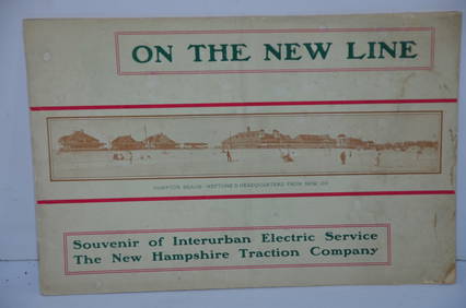
New Hampshire Traction Company 1901 On The New Line BookletJM Hobby Supply and Railroad Artifact Auctions4.4(126)See Sold PriceFeb 24, 2024
HOWARD HITCHMOUGH FOLDING KNIFE England/Peterborough, New Hampshire, Contemporary Length 2.5".Eldred's4.7(409)See Sold PriceFeb 28, 2024
1849 THE NEW-ENGLAND MERCANTILE UNIONNorth American Artifact Auctions4.6(182)See Sold PriceApr 20, 2024
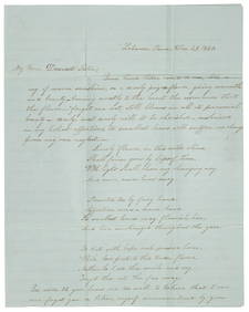
[CIVIL WAR]. Letter from Maurice Lamprey, 10th New Hampshire Infantry, in which he rejectsFreeman's | Hindman4.4(1.6k)See Sold PriceFeb 27, 2024
Mitchell - Map of the City of Washington (Washington, DC)Trillium Antique Prints & Rare Books4.5(30)See Sold PriceFeb 24, 2024
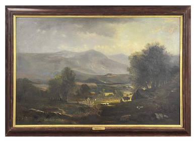
O/C BENJAMIN CHAMPNEY "NEW HAMPSHIRE LANDSCAPE" 19THC. (31 3/4" X 48")Carlsen Gallery, Inc.4.6(163)See Sold PriceMar 03, 2024
1862 North America Anthony Trollope West Indies AND Spanish Main CANADA NIAGARAJasper524.5(9.8k)See Sold PriceFeb 27, 2024
HAND-CRAFTED VIOLIN BY GERALD DASHNER Claremont, New Hampshire, Dated 1961 Violin length 24". WidthEldred's4.7(409)See Sold PriceMar 07, 2024
Two Hand-Colored 19th Century Maps of New Orleans and Louisiana, Larger- H.- 12 1/2 in., W.- 15 1/2Crescent City Auction Gallery4.3(229)See Sold PriceMar 08, 2024
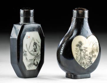
Chinese Enameled Copper Snuff Box w/ Ivory FiguresArtemis Fine Arts4.8(1.4k)See Sold PriceFeb 26, 2024
NEW HAMPSHIRE FEDERAL INLAID CHEST, CA. 1810.William Smith Auctions4.6(146)See Sold PriceMar 06, 2024
Super folky oil painting Professor Art Trinity College Mitchell Pappas FrameJasper524.5(9.8k)See Sold PriceMar 07, 2024
1950 oil painting Vermont "Beyond The Wall" Inscription On Back SnowJasper524.5(9.8k)See Sold PriceMar 07, 2024
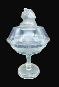
ANTIQUE EARLY AMERICAN PATTERNED GLASS COVERED COMPOTE LOVE BIRDS -C. 1870Jasper524.5(9.8k)See Sold PriceMar 07, 2024


![[CIVIL WAR]. Letter from Maurice Lamprey, 10th New Hampshire Infantry, in which he rejects (1 of 2)](https://p1.liveauctioneers.com/197/319238/171468115_1_x.jpg?height=282&quality=70&version=1707520367)