ATLAS of ANTIENT GEOGRAPHY by SAMUEL BUTLER 1843John McInnis Auctioneers,LLC4.6(502)See Sold PriceFeb 24, 2024
18TH C. ANTIQUE MAP: FRENCH & INDIAN WAR, FRAMEDThomaston Place Auction Galleries4.4(386)See Sold PriceFeb 24, 2024
Rand McNally Railroad Map Cabinet w/ 21 Railroad MapsRail & Road Auctions4.6(165)See Sold PriceMar 08, 2024
Keith Haring - Ink on New York Map, Best Buddies, Inscribed, Signed, and DatedSapphire Auction Gallery4(67)See Sold PriceMar 02, 2024
LATE 17TH C. FRENCH MAP OF THE NEW WORLD BY ALEXIS-HUBERT JAILLOT (1632-1712)Thomaston Place Auction Galleries4.4(386)See Sold PriceFeb 24, 2024
Central Railroad of New Jersey Map of Sandy Hook Route-ca. 1903JM Hobby Supply and Railroad Artifact Auctions4.4(126)See Sold PriceFeb 24, 2024
Lot of Six Mixed Atlas Box Cars-HO Scale-New in BoxJM Hobby Supply and Railroad Artifact Auctions4.4(126)See Sold PriceFeb 25, 2024
Rand McNally/Santa Fe Railroad Map of Iowa-1912JM Hobby Supply and Railroad Artifact Auctions4.4(126)See Sold PriceFeb 24, 2024
NICOLAES VISSCHER (NETHERLANDS, 1618-1709) MAP OF THE NEW WORLDThomaston Place Auction Galleries4.4(386)See Sold PriceFeb 24, 2024
17TH C. WORLD MAP BY NICOLAES VISSCHER (NETHERLANDS, 1618-1709)Thomaston Place Auction Galleries4.4(386)See Sold PriceFeb 24, 2024
Lot of Six Mixed Atlas Cabooses-HO Scale-New in BoxJM Hobby Supply and Railroad Artifact Auctions4.4(126)See Sold PriceFeb 25, 2024
Sold1870 Mitchell Map of Philadelphia -- Plan ofTitle: 1870 Mitchell Map of Philadelphia -- Plan of Philadelphia Cartographer: S Mitchell Year / Place: 1870, Philadelphia Map Dimension (in.): 11 X 13 in. This is an excellent map of Philadelphia. GrSee Sold Price
SoldMitchell: Antique Map of Philadelphia, 1870Title/Content of Map: 1870 Mitchell Map of Philadelphia -- Plan of Philadelphia Date Printed: 1870, Philadelphia Cartographer: S Mitchell Size: 11 X 12.8 in. A very nice map of the City of Brotherly LSee Sold Price
Mitchell: Antique Map of Philadelphia, 1870Title/Content of Map: 1870 Mitchell Map of Philadelphia -- Plan of Philadelphia Date Printed: 1870, Philadelphia Cartographer: S Mitchell Size: 11 X 12.8 in. A very nice map of the City of Brotherly LSee Sold Price
1870 Mitchell Map Of Cincinnati1870 Mitchell Map Of Cincinnati -- Plan Of Cincinnati And Vicinity Map: S. A. Mitchell, 1870, Philadelphia, 10.5 x 11 in. Cincinnati's 20 wards identified by number for census, and detailed view of stSee Sold Price
SoldMitchell: Antique Plan of Philadelphia, 1870Map: Plan of Philadelphia Cartographer: S. A. Mitchell Place & Date: Philadelphia / 1870 Size: 12 7/8" x 11 1/8" Condition: full color; light overall age toning The marvelously detailed and colored stSee Sold Price
SoldMitchell: Antique Map, City Plan of Boston, 1870Map: Plan of Boston Cartographer: S. A. Mitchell Place & Date: Philadelphia / 1870 Size: 9 3/8" x 11 1/8" Condition: full color; light overall age toning; some spotting in margins The marvelously detaSee Sold Price
Mitchell: Antique Plan of Chicago, 1870Map: Chicago Cartographer: S. A. Mitchell Place & Date: Philadelphia / 1870 Size: 11 1/8" x 13 3/4" Condition: full color; light overall age toning The beautifully detailed and colored street plan ofSee Sold Price
SoldMitchell: Antique Plan of Chicago, 1870Map: Chicago. Cartographer: S. A. Mitchell Place & Date: Philadelphia / 1870 Size: 11 1/8" x 13 3/4" Condition: full color; light overall age toning The beautifully detailed and colored street plan ofSee Sold Price
SoldMitchell: Antique Plan of Baltimore, 1870Map: Plan of Baltimore Cartographer: S. A. Mitchell Place & Date: Philadelphia / 1870 Size: 11" x 9 1/2" Condition: full color; light overall age toning The marvelously detailed and colored street plaSee Sold Price
Mitchell: Antique Plan of Boston, 1870Map: Plan of Boston Cartographer: S. A. Mitchell Place & Date: Philadelphia / 1870 Size: 9 3/8" x 11 1/8" Condition: full color; light overall age toning; some spotting in margins The marvelously detaSee Sold Price
Mitchell: Antique Plan of St. Louis, 1870Map: St. Louis Cartographer: S. A. Mitchell Place & Date: Philadelphia / 1870 Size: 10 7/8" x 13 7/8" Condition: full color; light overall age toning The beautifully detailed and colored street plan oSee Sold Price
SoldMitchell: Antique Plan of Washington DC, 1870Map: Plan of the City of Washington, the Capitol of the United States of America Cartographer: S. A. Mitchell Place & Date: Philadelphia / 1870 Size: 13 1/2" x 11 1/2" Condition: full color; light oveSee Sold Price
SoldMitchell: Antique Plan of New Orleans, 1870Title/Content of Map: Plan of New Orleans Cartographer: S. A. Mitchell Place & Date: Philadelphia / 1870 Size: 10 7/8" x 9 1/2" Condition: full color; light overall age toning; minor spotting in wideSee Sold Price
1876 Mitchell Map of Philadelphia -- Plan of the CityTitle/Content of Map: 1876 Mitchell Map of Philadelphia -- Plan of the City of Philadelphia and Camden Date: 1876 PhiladelphiaCartographer: S Mitchell Size: 14.6 X 22 in. This is an excellent double pSee Sold Price
1876 Mitchell Map of Philadelphia -- Plan of the CityTitle/Content of Map: 1876 Mitchell Map of Philadelphia -- Plan of the City of Philadelphia and Camden Date: 1876 Philadelphia Cartographer: S Mitchell Size: 14.6 X 22 in. This is an excellent doubleSee Sold Price
1870 Mitchell Map of Cincinnati -- Plan of CincinnatiTitle/Content of Map: 1870 Mitchell Map of Cincinnati -- Plan of Cincinnati and Vicinity Date: 1870, Philadelphia Cartographer: S. A. Mitchell Size: 10.5 x 11 Cincinnati's 20 wards identified by numbeSee Sold Price
1870 Mitchell Map of Cincinnati -- Plan of CincinnatiTitle/Content of Map: 1870 Mitchell Map of Cincinnati -- Plan of Cincinnati and Vicinity Date Printed: 1870, Philadelphia Cartographer: S. A. Mitchell Size: 10.5 x 11 Cincinnati's 20 wards identifiedSee Sold Price
SoldMitchell: Antique Map of Cincinnati, 1870Map: 1870 Mitchell Map of Cincinnati -- Plan of Cincinnati and Vicinity Cartographer: S. A. Mitchell Year / Place: 1870, Philadelphia Map Dimensions: 10.5 x 11 in. Condition: Very good; Good colors. SSee Sold Price
1872 Blanchard's Chicago Map One Year After The Fire1870 Mitchell Map Of Cincinnati -- Plan Of Cincinnati And Vicinity1872 Blanchard's Chicago Map One Year After The Fire R Blanchard, 1872, Chicago, 21 x 16 in. unfolded; 5.7 x 3.6 in. case This is an oSee Sold Price
Mitchell: Antique Map of Cincinnati, 1870Title/Content of Map: 1870 Mitchell Map of Cincinnati -- Plan of Cincinnati and Vicinity Date Printed: 1870, Philadelphia Cartographer: S. A. Mitchell Size: 10.5 x 11 in. Cincinnati's 20 wards identifSee Sold Price
SoldMitchell: Antique Map of Baltimore, 1870Map: 1870 Mitchell Map of Baltimore -- Plan of Baltimore Cartographer: S Mitchell Year / Place: 1870, Philadelphia Map Dimensions: 9 X 11.2 in. Condition: Very good; Pastel colors. Some age toning, moSee Sold Price
SoldSamuel A. Mitchell 'Plan of Philadelphia' Map 186012" X 13 1/2" map in a wood frame, under glass, Samuel Ausgustus Mitchell colored 'Plan of Philadelphia' map, circa1860, city plan naming streets, important buildings, Delaware River, rail lines and pSee Sold Price
1870 Mitchell Map of Nevada and Utah -- County Map ofTitle: 1870 Mitchell Map of Nevada and Utah -- County Map of Utah and Nevada Date: 1870, Philadelphia Cartographer: S Mitchell Size: 11.5 X 13.8 in. Additional Information: Very nice map with good detSee Sold Price
1870 Mitchell Map of New Hampshire and Vermont -- NewTitle: 1870 Mitchell Map of New Hampshire and Vermont -- New Hampshire and Vermont Date: 1870, Philadelphia Cartographer: S Mitchell Size: 13.6 x 11.4 in. Additional Information: This is a very nice mSee Sold Price
1849 Mitchell School ATLAS 24 MAPS America Holy Land France Africa Egypt AsiaSchilb Antiquarian Rare Books4.8(421)See Sold PriceMar 31, 2024
1868 and 1870 Philadelphia & Reading Railroad Annual PassesRail & Road Auctions4.6(165)See Sold PriceMar 08, 2024
Mitchell - Map of the City of Washington (Washington, DC)Trillium Antique Prints & Rare Books4.5(30)See Sold PriceFeb 24, 2024
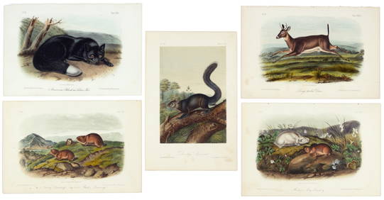
First 50 plates from Audubon's Quad Quarto (all in Vol. I)PBA Galleries4.7(381)See Sold PriceMar 07, 2024
Nearly complete set of plates from Vol. III Quad QuartoPBA Galleries4.7(381)See Sold PriceMar 07, 2024
West Africa by Arrowsmith & Lewis 1812 old antique vintage map plan chartJasper524.5(9.8k)See Sold PriceFeb 28, 2024
AFRICA. Pre 'Scramble for Africa'. BARTHOLOMEW 1876 old antique map plan chartJasper524.5(9.8k)See Sold PriceFeb 28, 2024
Carte d'Afrique. Africa Soudan Zanzibar. LAPIE 1831 old antique map plan chartJasper524.5(9.8k)See Sold PriceFeb 28, 2024
Western Sahara. Africa 1885 old antique vintage map plan chartJasper524.5(9.8k)See Sold PriceFeb 28, 2024
AFRICA. Africa. Britannica 9th edition 1898 old antique vintage map plan chartJasper524.5(9.8k)See Sold PriceFeb 28, 2024
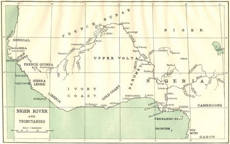
AFRICA. Niger River and Tributaries 1936 old vintage map plan chartJasper524.5(9.8k)See Sold PriceFeb 28, 2024
AFRICA. French North Africa and Morocco 1907 old antique map plan chartJasper524.5(9.8k)See Sold PriceFeb 28, 2024
Showers of Red Dust. Africa. Sahara 1886 old antique vintage map plan chartJasper524.5(9.8k)See Sold PriceFeb 28, 2024
Africa by Arrowsmith & Lewis 1812 old antique vintage map plan chartJasper524.5(9.8k)See Sold PriceFeb 28, 2024
Two Hand-Colored 19th Century Maps of New Orleans and Louisiana, Larger- H.- 12 1/2 in., W.- 15 1/2Crescent City Auction Gallery4.3(229)See Sold PriceMar 08, 2024