ATLAS of ANTIENT GEOGRAPHY by SAMUEL BUTLER 1843John McInnis Auctioneers,LLC4.5(505)See Sold PriceFeb 24, 2024
18TH C. ANTIQUE MAP: FRENCH & INDIAN WAR, FRAMEDThomaston Place Auction Galleries4.4(393)See Sold PriceFeb 24, 2024
Rand McNally Railroad Map Cabinet w/ 21 Railroad MapsRail & Road Auctions4.6(165)See Sold PriceMar 08, 2024
Keith Haring - Ink on New York Map, Best Buddies, Inscribed, Signed, and DatedSapphire Auction Gallery4(67)See Sold PriceMar 02, 2024
LATE 17TH C. FRENCH MAP OF THE NEW WORLD BY ALEXIS-HUBERT JAILLOT (1632-1712)Thomaston Place Auction Galleries4.4(393)See Sold PriceFeb 24, 2024
Central Railroad of New Jersey Map of Sandy Hook Route-ca. 1903JM Hobby Supply and Railroad Artifact Auctions4.4(127)See Sold PriceFeb 24, 2024
Lot of Six Mixed Atlas Box Cars-HO Scale-New in BoxJM Hobby Supply and Railroad Artifact Auctions4.4(127)See Sold PriceFeb 25, 2024
Rand McNally/Santa Fe Railroad Map of Iowa-1912JM Hobby Supply and Railroad Artifact Auctions4.4(127)See Sold PriceFeb 24, 2024
NICOLAES VISSCHER (NETHERLANDS, 1618-1709) MAP OF THE NEW WORLDThomaston Place Auction Galleries4.4(393)See Sold PriceFeb 24, 2024
17TH C. WORLD MAP BY NICOLAES VISSCHER (NETHERLANDS, 1618-1709)Thomaston Place Auction Galleries4.4(393)See Sold PriceFeb 24, 2024
Lot of Six Mixed Atlas Cabooses-HO Scale-New in BoxJM Hobby Supply and Railroad Artifact Auctions4.4(127)See Sold PriceFeb 25, 2024
Sold1847 Geological Map of Lake Superior & Michigan"Geological Map of the Lake Superior Land District in the State of Michigan". J. W. Foster and J. D. Whitney, U.S. geologists. Lithographed by J. Ackerman, Broadway, New York. Areas of hand coloring wSee Sold Price
Grouping of Historic MapsGrouping of six historic maps including; 1.) Map titled"Geological Map of The District Between Keweenaw Bay and Chocolate River, Lake Superior, Michigan" published in New York by Ackerman"s LithographSee Sold Price
SoldAmerica.- Foster (J.W.) & Whitney (J.D.) Geological MapNO RESERVE America.- Foster (J.W.) & Whitney (J.D.) Geological Map of the Lake Superior Land District in the State of Michigan, showing the geology of the Upper Michigan Peninsula, Isle Royale and theSee Sold Price
Two geological maps of Michigan c.1847Title: Two geological maps of Michigan Author: Foster, J.W. & J.D. Whitney Description: Includes: Geological Map of the Lake Superior Land District in the State of Michigan. Prepared Pursuant to an AcSee Sold Price
SoldColton: Antique Map of Lake Superior & Michigan, 1859Title/Content of Map: Lake Superior & UP of Michigan by Colton Date Printed: 1859 Cartographer: H. J. Colton Material/Medium: Paper Size: 17 1/2" x 15" Hand colored engraved. Published in New York inSee Sold Price
SoldLake Superior Maps, Foster & Whitney's Report[Michigan/Lake Superior Maps] 2 Items incl. maps showing Lake Superior, Michigan, from Foster & Whitney's Report, c. 1850. Map volume from: John Wells Foster and Josiah D. Whitney. [REPORT ON THE GEOLSee Sold Price
Map of the Great Lakes of Superior & Michigan, 1702Domestic: Free Shipping Map Title: Map of the Great Lakes of Superior & Michigan (Ilinese Lake). Date: 1702 Maker: Lahonton Medium: Copperplate engraving. Size: 13.5x18.5 inches. Very rare map with liSee Sold Price
SoldThree framed maps including Pennsylvania, UpperThree framed maps including Pennsylvania, Upper Territories Lake Superior, Michigan, and Missouri. sight sizes 13 1/2" x 19 1/2", 17 1/2" x 13 1/2", and 16 1/2" x 21"See Sold Price
Sold[United States]. 4 Maps.[United States]. 4 Maps. ++ Lake Superior And The Northern Part Of Michigan. J. H. Colton: 1855. 11 1/2 x 13 3/4, hand-colored. Corners torn, minor edgewear, map unaffected. ++ Map Of The Central StatSee Sold Price
Sold1857 Colton Map of Lake Superior and the Northern PartReserve Reduced! Title/Content of Map: 1857 Colton Map of Lake Superior and the Northern Part of Michigan -- Lake Superior and the Northern Part of Michigan Date: 1857, New York Cartographer: J ColtonSee Sold Price
Sold1855 Colton Map of Lake Superior and the UpperTitle: 1855 Colton Map of Lake Superior and the Upper Peninsula of Michigan-- Lake Superior and the Northern Part of Michigan Cartographer: J Colton Date: 1855, New York Size: 11.8 X 15.5 in. AdditionSee Sold Price
Sold1855 Colton Map of Lake Superior and the Northern PartTitle: 1855 Colton Map of Lake Superior and the Northern Part of Michigan -- Lake Superior and the Northern Part of Michigan Cartographer: J Colton Year / Place: 1855, New York Map Dimension (in.): 11See Sold Price
1855 Colton Map of Lake Superior and the Northern PartTitle: 1855 Colton Map of Lake Superior and the Northern Part of Michigan -- Lake Superior and the Northern Part of Michigan Cartographer: J Colton Year / Place: 1855, New York Map Dimension (in.): 11See Sold Price
1855 Colton Map of Lake Superior and the Northern PartTitle/Content of Map: 1855 Colton Map of Lake Superior and the Northern Part of Michigan -- Lake Superior and the Northern Part of Michigan Cartographer: J Colton Year/Place: 1855, New York Size: 11.8See Sold Price
1855 Colton Map of Lake Superior and the UpperTitle/Content of Map: 1855 Colton Map of Lake Superior and the Upper Peninsula of Michigan -- Lake Superior and the Northern Part of Michigan Date: 1855, New York Cartographer: J Colton Size: 11.8 X 1See Sold Price
Sold2 Hand Colored Maps - MichiganTwo Gray's Atlas Maps on one sheet - Michigan & Lake Superior and the Northern Part of Michigan Depicts railroad lines, common roads, canals, topography, etc. Maps are on eaSee Sold Price
2 Hand Colored Maps - MichiganTwo Gray's Atlas Maps on one sheet - Michigan & Lake Superior and the Northern Part of Michigan Depicts railroad lines, common roads, canals, topography, etc. Maps aSee Sold Price
2 Hand Colored Maps - MichiganTwo Gray's Atlas Maps on one sheet - Michigan & Lake Superior and the Northern Part of Michigan Depicts railroad lines, common roads, canals, topography, etc. Maps aSee Sold Price
2 Hand Colored Maps - MichiganTwo Gray's Atlas Maps on one sheet - Michigan & Lake Superior and the Northern Part of Michigan Depicts railroad lines, common roads, canals, topography, etc. Maps aSee Sold Price
2 Hand Colored Maps - MichiganTwo Gray's Atlas Maps on one sheet - Michigan & Lake Superior and the Northern Part of Michigan Depicts railroad lines, common roads, canals, topography, etc. Maps aSee Sold Price
2 Hand Colored Maps - MichiganTwo Gray's Atlas Maps on one sheet - Michigan & Lake Superior and the Northern Part of Michigan Depicts railroad lines, common roads, canals, topography, etc. Maps are oSee Sold Price
2 Hand Colored Maps - MichiganTwo Gray's Atlas Maps on one sheet - Michigan & Lake Superior and the Northern Part of Michigan Depicts railroad lines, common roads, canals, topography, etc. Maps aSee Sold Price
2 Hand Colored Maps - MichiganTwo Gray's Atlas Maps on one sheet - Michigan & Lake Superior and the Northern Part of Michigan Depicts railroad lines, common roads, canals, topography, etc. Maps aSee Sold Price
2 Hand Colored Maps - MichiganTwo Gray's Atlas Maps on one sheet - Michigan & Lake Superior and the Northern Part of Michigan Depicts railroad lines, common roads, canals, topography, etc. Maps aSee Sold Price
Lake Superior and Mississippi River RR 1869 Seven Percent Bonds Book/Report-1869JM Hobby Supply and Railroad Artifact Auctions4.4(127)See Sold PriceFeb 24, 2024
Michigan Southern and Northern Indiana RR 14th Annual Report-February 28, 1869JM Hobby Supply and Railroad Artifact Auctions4.4(127)See Sold PriceFeb 24, 2024
St Croix and Lake Superior RR General Specifications for Construction Document-1856JM Hobby Supply and Railroad Artifact Auctions4.4(127)See Sold PriceFeb 24, 2024
Stillwater and St Paul/Lake Superior and Mississippi RR Mortgage/Lease Agreement-1870JM Hobby Supply and Railroad Artifact Auctions4.4(127)See Sold PriceFeb 24, 2024
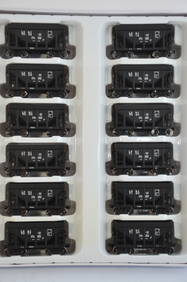
Lake Superior and Ishpeming RR 12-Pack Walthers Ore Cars-HO Scale-New in BoxJM Hobby Supply and Railroad Artifact Auctions4.4(127)See Sold PriceFeb 25, 2024
Lake Superior and Ishpeming RR 12-Pack Walthers Ore Cars-HO Scale-New in BoxJM Hobby Supply and Railroad Artifact Auctions4.4(127)See Sold PriceFeb 25, 2024
DEVINE c1856 Dr Salters Map Of Lake Huron Ontario Indian Lands etc. No. 7 ScarceLuis Porretta Fine Arts4.3(10)See Sold PriceMar 02, 2024
19thc Colton Map, Comparitive Size of Lakes & IslandsConnoisseur Auctions3.9(336)See Sold PriceFeb 24, 2024
Two Lake Shore & Michigan Southern Railway Adams & Westlake Lantern Frames and Boxcar Door HandleRail & Road Auctions4.6(165)See Sold PriceMar 07, 2024
Adams & Westlake Lake Shore & Michigan Southern Double Wire Guard Lantern w/ Clear Cast GlobeRail & Road Auctions4.6(165)See Sold PriceMar 07, 2024
Group of Lake Shore & Michigan Southern Railroad PaperRail & Road Auctions4.6(165)See Sold PriceMar 07, 2024
Pere Marquette Railway and Ann Arbor Railroad Ferry PostersRail & Road Auctions4.6(165)See Sold PriceMar 07, 2024
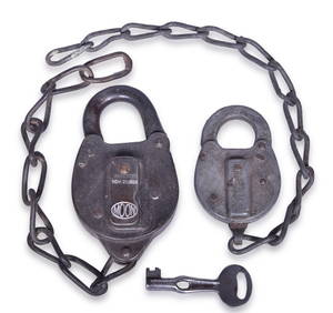
Pair of Lake Shore & Michigan Southern Railroad Locks and KeyRail & Road Auctions4.6(165)See Sold PriceMar 07, 2024
Lake Shore & Michigan Southern Railroad Extended Base Clear Cast GlobeRail & Road Auctions4.6(165)See Sold PriceMar 07, 2024
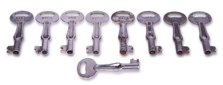
Nine Railroad Lock Oiler Keys - Lake Shore & Michigan Southern Railroad and New York CentralRail & Road Auctions4.6(165)See Sold PriceMar 07, 2024
Eleven Pieces of Midwest Railroad Flatware - Louisville & Nashville, Lake Shore & Michigan Southern,Rail & Road Auctions4.6(165)See Sold PriceMar 08, 2024
Dupont Dulux Marine Finishes Whitmore Lake Michigan Advertising Paint SignHoller and Hammer4.6(64)See Sold PriceFeb 25, 2024
Antique Native American 5 Piece Lot: Deerskin Jacket & Pants, Rug, Drum, Michigan Map & Mule DeerHoller and Hammer4.6(64)See Sold PriceFeb 24, 2024
Stanford, Edward 1901 Large Map. Geological Map of the British IslesAlbion Auctions4.6(341)See Sold PriceMar 01, 2024
Agate, Rock, Crystal, Natural, Collectible, Specimen,Easterly Auction Company4.7(433)See Sold PriceFeb 27, 2024
HIROSHI SUGIMOTO, LAKE SUPERIOR, CASCADE RIVER, 1995White Knight Auction, Inc4.7(252)See Sold PriceMar 03, 2024


![[United States]. 4 Maps. (1 of 1)](https://p1.liveauctioneers.com/179/1435/617538_1_x.jpg?height=282&quality=70)