SoldA mixed group of maps and plans of London and envA mixed group of maps and plans of London and environs,City Wards, plans for reconstructing the City after the Great Fire, maps of 20 miles around London, some incomplete sections of larger sSee Sold Price
SoldLondon.- Mixed group London plansMixed group of maps and plans of London,including a small group of city ward plans from Stow's Survey,1755, several by Stockdale, including Stepney, Limehouse, Peckham, Hampstead, Greewich anSee Sold Price
SoldHouse Of Commons. mixed plans of LondonHouse Of Commons. Publisher A mixed group of plans and maps of London, including several of Downing Street and the Foreign Office, several of the Embankment and sewer networks, several plans oSee Sold Price
A mixed group of maps,A mixed group of maps, atlases and London related material, including a London underground map, 1926; The Post Office London Directory street plan, 1965; The Official Railway Map of EnglandSee Sold Price
SoldA Mixed Group Of British Town PlansA Mixed Group of British Town Plans, including London, Liverpool, Cambridge, Oxford Cardiff and several folding town plans, engraved maps, some with hand-colouring, v.s., various conditions,See Sold Price
Sold-. large mixed group of maps, plans, and topograp-. large mixed group of maps, plans, and topographical views (A)including maps of Europe, Asia Minor, and with plans of Venice and Rome, an elevation of the facade of the Orangery at VersaillSee Sold Price
SoldGreek Islands.- a mixed group of maps and plansGreek Islands.- a mixed group of maps and plans,including Tobias Conrad Lotter's Graeciae Antiquae Designatio Nova ..., and with maps by or after Kauffer, Tardieu, d'Anville, and others, engraSee Sold Price
SoldMediterranean.- A mixed group of maps and plansMediterranean.- A mixed group of maps and plans,including 43 maps by Joseph Roux, from 'Plans et Rades de la Méditerraneé', and others by or after Tardieu, Bernard, Gouffier, and others, engraSee Sold Price
Solda mixed group of maps and plansa mixed group of maps and plans,including maps by or after Blome, Bowen, Arrowsmith, and others, mainly of the Middle East, particularly of the Levant, with a small section of plates relatingSee Sold Price
SoldEurope. a mixed group of maps and plansEurope. a mixed group of national and regional maps and plans,including A New Map of Muscovy, from the English edition Olearius's The Voyages & Travels of the Ambassador Sent by Frederick DukeSee Sold Price
SoldLow Countries.- A mixed group of maps and plans ofLow Countries.- A mixed group of maps and plans of Holland and Belgium,by or after Tardieu, Harrewyn, Kitchin, Archer and others, including SDUK and Tallis plans of Brussels, engraved and lithSee Sold Price
SoldA mixed group of regional maps and plans of England andincluding a locally published cloth Map of the Country Eight Miles Round Malvern, by H. Lamb & Son; a locally published cloth 'weather-proof' edition of Bacon's map of the Isle of Wight, by W. CouldreSee Sold Price
SoldA small, mixed group of maps and town plans of EnBritish Isles.- A small, mixed group of maps and town plans of England and Scotland, including several of Kent and the Isle of Thannet, the Isle of White, road maps and town plans, including TSee Sold Price
SoldA small, mixed group of national maps and town plBritish Isles.- A small, mixed group of national maps and town plans, including plans of New York, Brussels, Liverpool, Odessa and others, mostly European, engraved and lithographic maps, someSee Sold Price
A group of 10 folding maps and plans of London anA group of 10 folding maps and plans of London and environs,including Bacon's Map of London with the Railways in Operation and Constructing, 1868; Rugg's Handy Reference Map of London, 1890;See Sold Price
SoldEast London.- A mixed group of mapsEast London.- A mixed group of maps,including a manuscript map of Bethnal Green after the 1703 engraving by Gascoyne, with 9 engraved maps, 1 from John Stow's Survey, and others of WhitechapelSee Sold Price
SoldCambridgeshire.- a mixed group of county mapsCambridgeshire.- a mixed group of small county maps,some with inset plans or vignette views and other ornamentation, by, for or after Blome, Cary, Moll, Morden, Moule, Ramble, Rocque, Seller,See Sold Price
SoldA mixed group of facsimile prints and panoramas oThames.- A mixed group of facsimile panoramas, prints and maps of London, including several of the Thames valley, and Twickenham, by or after R. Havell, W. Parrot, and others, lithographs, v.See Sold Price
SoldA mixed group of maps of North AmericaA mixed group of maps of North America,including a plan of New York, and parts of Canada, by Sidney Hall, Johnston, Day & Son, and others, engravings, lithographs, some printed in colour, v.sSee Sold Price
SoldCambridgeshire.- a mixed group of county maps-. a mixed group of small county maps,including a detailed plan of Bury St Edmunds, by Henshall after Dawson, and the Fens of the Bedford Levels, by R. Walker, some of the county maps with insSee Sold Price
SoldSussex.- - A mixed group of mostly smaller maps of theincluding Drayton's Poly-olbion map of Sussex, Surrey and Middlesex, 2 variant states of the Norden/Kip map for Camden's Britannia, Ogilby's strip road map from London to Rye, and others by Blome, MorSee Sold Price
SoldEurope.- A mixed group of mapsEurope.- A mixed group of maps,including regional and national maps, with the 'Plans of the provinical towns of Ireland for Mr Tindal's Continuation of Mr Rapin's History', a map of BirminghamSee Sold Price
Soldmixed group of maps of the West CountryWest Country.- a mixed group of maps of the West Country,Avon and Somerset, Dorset, Devon and Cornwall, mostly county maps, but including town plans of Bristol and Plymouth, by or after Bowen,See Sold Price
A mixed group of mostly smaller maps of the county,including Drayton's Poly-olbion map of Sussex, Surrey and Middlesex, 2 variant states of the Norden/Kip map for Camden's Britannia, Ogilby's strip road map from London to Rye, and others by Blome, MorSee Sold Price
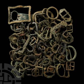
Medieval Bronze Equine Bridle Strap Slide GroupTimeLine Auctions Ltd.4.6(183)See Sold PriceMar 07, 2024
Assortment of Railroad Paper - Rule Books, Stationary, Ink Blotter, Map, Timetables, and MoreRail & Road Auctions4.6(165)See Sold PriceMar 07, 2024
Group of Ten Railroad Photographs, Maps, and Prints - New Jersey, Long Island, and New YorkRail & Road Auctions4.6(165)See Sold PriceMar 07, 2024