A group of 10 folding maps and plans of London anA group of 10 folding maps and plans of London and environs,including Bacon's Map of London with the Railways in Operation and Constructing, 1868; Rugg's Handy Reference Map of London, 1890;See Sold Price
SoldA Mixed Group Of British Town PlansA Mixed Group of British Town Plans, including London, Liverpool, Cambridge, Oxford Cardiff and several folding town plans, engraved maps, some with hand-colouring, v.s., various conditions,See Sold Price
SoldGroup of Seven Christian BooksGroup of seven Christian Books. Includes: 1) Scripture Atlas Consisting of Eighteen Maps and Plans. Samuel Bagster and Sons, London. Ca 1858. Owner writing front flyleaf. Explanatory List with 10 doubSee Sold Price
SoldBLUE GUIDES. A group of two Blue Guides.BLUE GUIDES. A group of two Blue Guides. Paris and its Environs. London: Macmillan & Co. and Paris: Librairie Hachette, 1927 [but later]. 8vo. Numerous maps and plans (some folding). Original flexibleSee Sold Price
SoldGrp: 10 Maps of British Cities w/ 1 Map VeniceGroup of maps of British cities. Includes one map of Birmingham; two road maps for the London area: "A Map of the New Roads & c. from Westminster Bridge" and "A Plan of the intended New Road from PadiSee Sold Price
SoldManstein (Christoph Hermann von)Manstein (Christoph Hermann von) Memoirs of Russia, Historical, Political, and Military,[edited by David Hume], first edition, 10 folding engraved maps and plans, title and some other ff. a feSee Sold Price
SoldMiscellaneous Reports Dept. of Interior US 1899Title: Annual Reports of the Department of the Interior for the Fiscal Year Ended June 30, 1899. Miscellaneous Reports. Part II. Author: ** Description: 882 pp. 10 folding maps and/or plans; many platSee Sold Price
SoldIreland.- MusgraveIreland.- Musgrave (Sir Richard) Memoirs of the different Rebellions in Ireland..., second edition, half-title, 10 folding engraved maps and plans, 1 folding engraved plate, light spotting andSee Sold Price
SoldLondon and its Environs Described,6 vol., 1 folding map only (plan of London, lacking map of environs and another), numerous engraved plates including various plates, clippings and similar from various other sources, some with ms. notSee Sold Price
SoldA mixed group of maps and plans of London and envA mixed group of maps and plans of London and environs,City Wards, plans for reconstructing the City after the Great Fire, maps of 20 miles around London, some incomplete sections of larger sSee Sold Price
SoldLondon.- Mixed group London plansMixed group of maps and plans of London,including a small group of city ward plans from Stow's Survey,1755, several by Stockdale, including Stepney, Limehouse, Peckham, Hampstead, Greewich anSee Sold Price
Nansen (Fridtjof) First Crossing of GreenlandNansen (Fridtjof) The First Crossing of Greenland,2 vol., first edition, half-titles, frontispiece portraits, 10 plates, 4 folding maps and plans only (of 5), hinges and half-titles reinforcedSee Sold Price
SoldLewis. A Topographical Dictionary of EnglandLewis (Samuel) A Topographical Dictionary of England,4 vol., 43 folding engraved maps, lacking plan of London, half-titles, 2 ff. repaired at fore-edges, contemporary half calf, worn and rebacSee Sold Price
SoldDorsetshire.- Hutchins (John) The History and AntiDorsetshire.- Hutchins (John) The History and Antiquities of the County of Dorset,2 vol., first edition, engraved folding map, 10 plans (4 folding) and 49 plates (9 folding), vignette illustraSee Sold Price
Dorsetshire.- Hutchins (John) The History and AntiDorsetshire.- Hutchins (John) The History and Antiquities of the County of Dorset,2 vol., first edition, engraved folding map, 10 plans (4 folding) and 49 plates (9 folding), vignette illustraSee Sold Price
SoldVINTAGE LINEN BACK FOLDING MAP WYLDS, LONDONVINTAGE LINEN BACK FOLDING MAP WYLDS NEW PLAN OF LONDON AND ITS VICINITY, 1889. FRAMED AND GLAZED-30 1/2 X 37 1/2"See Sold Price
Soldpublisher ) The London and Birmingham Railway Guide ,publisher ) The London and Birmingham Railway Guide , first edition , large folding engraved map frontispiece, folding plan of London, bookseller's small sticker on front pastedown, original gilt-pictSee Sold Price
1786 History Of Late Siege Of GibralterDrinkwater, John 2nd Edition London 9 of 10 folding maps and platesvbery clean except for a few spots on some page edgesSee Sold Price
1786,Drinkwater, John,History Of The Late Siege Of2nd Edition,J.Johnson& J. Edwards,London ,9 of 10 folding maps and platesvbery clean except for a few spots on some page edgesSee Sold Price
SoldFuller (Thomas) The Church-History of BritainGray (Thomas).- Stanza's Written in a Country Church-yard,2 vol., pirate edition, found in "The Magazine of Magazines", engraved frontispieces, 10 plates (5 folding) and 6 maps and Plans (5 foSee Sold Price
Gray (T.).- Stanza's Written in a Church-yardGray (Thomas).- Stanza's Written in a Country Church-yard,2 vol., pirate edition, found in "The Magazine of Magazines", engraved frontispieces, 10 plates (5 folding) and 6 maps and Plans (5 foSee Sold Price
SoldGray (Thomas).- Country Church-yardGray (Thomas).- Stanza's Written in a Country Church-yard,2 vol., pirate edition, found in "The Magazine of Magazines", engraved frontispieces, 10 plates (5 folding) and 6 maps and Plans (5 foSee Sold Price
Sold1784 Folding Map of Persia1784 “A New Map of Persia by J. Bayly”, published by Harrsion and Co., London. Folding map measuring 10 x 15”, Fine condition. Reserve: $30.00 Shipping: Domestic: Flat-rate of $5.00 to anywhereSee Sold Price
1784 Folding Map of Persia1784 “A New Map of Persia by J. Bayly”, published by Harrsion and Co., London. Folding map measuring 10 x 15”, Fine condition. Reserve: $30.00 Shipping: Domestic: Flat-rate of $10.00 to anywhereSee Sold Price
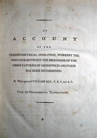
WILLIAM ROY Rare Navigation Book c1797 Trigonometry Between Paris & GreenwichLuis Porretta Fine Arts4.3(10)See Sold PriceMar 02, 2024
General Books - Boyle - London: A Cartographic History 1746-1950, 200 Years of Folding MapsTimeLine Auctions Ltd.4.6(182)See Sold PriceMar 08, 2024
Natural History - Agate Crystal Geode Cut Half Group [10].TimeLine Auctions Ltd.4.6(182)See Sold PriceMar 08, 2024
Natural History - Boxed Selenite Mineral Specimen Group [10].TimeLine Auctions Ltd.4.6(182)See Sold PriceMar 08, 2024
Natural History - Large Green Fuchsite Mineral Specimen Group [10].TimeLine Auctions Ltd.4.6(182)See Sold PriceMar 08, 2024
Collection of 10 Maps of Cities in Israel for TouristsLevy Auction House4.3(11)See Sold PriceFeb 27, 2024
Natural History - Boxed Topaz Mineral Specimen Group [10].TimeLine Auctions Ltd.4.6(182)See Sold PriceMar 09, 2024
Natural History - Amethyst Crystal Geode Section Group [10].TimeLine Auctions Ltd.4.6(182)See Sold PriceMar 09, 2024
Natural History - Unpolished Fossil Tree Branch Section Group [10]TimeLine Auctions Ltd.4.6(182)See Sold PriceMar 09, 2024
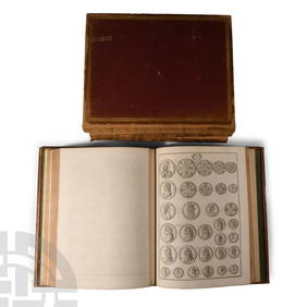
Numismatic Books - Rudding's Coinage of Britain Vol I-III, Plus SuplementTimeLine Auctions Ltd.4.6(182)See Sold PriceMar 09, 2024
[ADVERTISING FOLDING FANS]. Group of 10 Folding Fans Advert...Potter & Potter Auctions4.6(544)See Sold PriceMar 07, 2024
1800 MUNGO PARK TRAVELS to AFRICA 2 VOLS w/ MAP antique in ENGLISHJasper524.5(9.8k)See Sold PriceFeb 27, 2024
1749-59 21 volumes NETHERLANDS HISTORY ILLUSTRATED antique VELLUM BOUNDJasper524.5(9.8k)See Sold PriceFeb 27, 2024
Emory's Notes of a Military Reconnoissance larger issuePBA Galleries4.7(383)See Sold PriceMar 07, 2024
AFRICA. Africa. Britannica 9th edition 1898 old antique vintage map plan chartJasper524.5(9.8k)See Sold PriceFeb 28, 2024
Young Crocodile, drawn in London October 1739. Sea toad. Cuttlefish. SCHLEY 1747Jasper524.5(9.8k)See Sold PriceFeb 28, 2024
Showers of Red Dust. Africa. Sahara 1886 old antique vintage map plan chartJasper524.5(9.8k)See Sold PriceFeb 28, 2024
OLD ILLUSTRATED 1902 CROSS-COVERED LANDS JOURNEY TO CALCUTTA, INDIA, 2 VOLUMESNY Elizabeth 4.3(85)See Sold PriceMar 03, 2024
[Constructivism]. The general plan of reconstruction of Moscow. - Moscow: Moscow Worker, 1936. -ARTMAXIMUM4.3(4)See Sold PriceMar 14, 2024


![Natural History - Agate Crystal Geode Cut Half Group [10]. (1 of 1)](https://p1.liveauctioneers.com/1191/317892/170615738_1_x.jpg?height=282&quality=70&version=1706617191)
![Natural History - Boxed Selenite Mineral Specimen Group [10]. (1 of 1)](https://p1.liveauctioneers.com/1191/317892/170615796_1_x.jpg?height=282&quality=70&version=1706617191)
![Natural History - Large Green Fuchsite Mineral Specimen Group [10]. (1 of 1)](https://p1.liveauctioneers.com/1191/317892/170615894_1_x.jpg?height=282&quality=70&version=1706617191)

![Natural History - Boxed Topaz Mineral Specimen Group [10]. (1 of 1)](https://p1.liveauctioneers.com/1191/317894/170617096_1_x.jpg?height=282&quality=70&version=1706620797)
![Natural History - Amethyst Crystal Geode Section Group [10]. (1 of 1)](https://p1.liveauctioneers.com/1191/317894/170617126_1_x.jpg?height=282&quality=70&version=1706620797)
![Natural History - Unpolished Fossil Tree Branch Section Group [10] (1 of 1)](https://p1.liveauctioneers.com/1191/317894/170617154_1_x.jpg?height=282&quality=70&version=1706620797)
![[ADVERTISING FOLDING FANS]. Group of 10 Folding Fans Advert... (1 of 1)](https://p1.liveauctioneers.com/928/318880/171360910_1_x.jpg?height=282&quality=70&version=1707501302)


![[Constructivism]. The general plan of reconstruction of Moscow. - Moscow: Moscow Worker, 1936. - (1 of 6)](https://p1.liveauctioneers.com/6171/320219/172084257_1_x.jpg?height=282&quality=70&version=1708525949)