ATLAS of ANTIENT GEOGRAPHY by SAMUEL BUTLER 1843John McInnis Auctioneers,LLC4.6(502)See Sold PriceFeb 24, 2024
18TH C. ANTIQUE MAP: FRENCH & INDIAN WAR, FRAMEDThomaston Place Auction Galleries4.4(386)See Sold PriceFeb 24, 2024
Rand McNally Railroad Map Cabinet w/ 21 Railroad MapsRail & Road Auctions4.6(165)See Sold PriceMar 08, 2024
Keith Haring - Ink on New York Map, Best Buddies, Inscribed, Signed, and DatedSapphire Auction Gallery4(67)See Sold PriceMar 02, 2024
LATE 17TH C. FRENCH MAP OF THE NEW WORLD BY ALEXIS-HUBERT JAILLOT (1632-1712)Thomaston Place Auction Galleries4.4(386)See Sold PriceFeb 24, 2024
Central Railroad of New Jersey Map of Sandy Hook Route-ca. 1903JM Hobby Supply and Railroad Artifact Auctions4.4(126)See Sold PriceFeb 24, 2024
Lot of Six Mixed Atlas Box Cars-HO Scale-New in BoxJM Hobby Supply and Railroad Artifact Auctions4.4(126)See Sold PriceFeb 25, 2024
Rand McNally/Santa Fe Railroad Map of Iowa-1912JM Hobby Supply and Railroad Artifact Auctions4.4(126)See Sold PriceFeb 24, 2024
NICOLAES VISSCHER (NETHERLANDS, 1618-1709) MAP OF THE NEW WORLDThomaston Place Auction Galleries4.4(386)See Sold PriceFeb 24, 2024
17TH C. WORLD MAP BY NICOLAES VISSCHER (NETHERLANDS, 1618-1709)Thomaston Place Auction Galleries4.4(386)See Sold PriceFeb 24, 2024
Lot of Six Mixed Atlas Cabooses-HO Scale-New in BoxJM Hobby Supply and Railroad Artifact Auctions4.4(126)See Sold PriceFeb 25, 2024
1849 map of Lake ChamplainTitle: 1849 map of Lake Champlain Description: Map of Lake Champlain from Fort Chambly to Fort St. Frederic or Crown Point, Survey'd by Mr. Anger, King's Surveyor in 1732, Made at Quebec the 10 OctobeSee Sold Price
Sold1849 Map Fr. & Eng. Grants Lake ChamplainBy Richard H. Pease 14 1/2" x 23 1/2" FrameSee Sold Price
SoldJefferys' 18th Century Map of Lake ChamplainA Survey of Lake Champlain, including Lake George, Crown Point and St. John... Thomas Jefferys (c. 1719 – 1771). Copperplate engraved map with handcolor in outline. London: Sayer & Bennett, 1776. 21See Sold Price
Sold1911 S R Stoddard Map of Lake Champlain1911 S R Stoddard folding map of Lake Champlain, with original boards, tears along folds, slight losses, 37" x 10 1/2"See Sold Price
Sold1890 Stoddard Map of Lake Champlain1890 Map of Lake Champlain Compiled & Published by S R Stoddard Glensfalls NY. Lithograph by L E Neuman & Co NY. 10 1/2" x 36 1/2". Original map with cartouches of Plattsburgh, Richelieu River, Lake GSee Sold Price
Sold1744 Jacques Nicolas Bellin Map of Lake Champlain1744 Jacques Nicolas Bellin- Carte de la Riviere de Richelieu et du Lac ChamplainSee Sold Price
Sold(4) FRAMED ITEMS BOSTON, MAPS, DARTMOUTHHand colored Boston Harbor scene, size 10 x 15, Boston Street Map hand colored, size 10.5 x 14, photo of a toppo map of Lake Champlain, size 10.5 x 8, Print Dartmouth College, size 3.5 x 6 Condition:See Sold Price
SoldFour VT MapsLate20th c Stoddard map of Lake Champlain, Map of Grand Isle; Map of Colchester, Map of Maine, New Hampshire and VermontSee Sold Price
SoldLake Champlain Map and Steamship PhotosLake Champlain and Lake George map & three photographs of Champlain Transportation steam ships- Ticonderoga, Horicon, Mohican, allmatted in single frame, photo image sizes 5 1/2" x 7 1/2"See Sold Price
Sold1776 LAKE CHAMPLAIN MAP BY BRASSIERFramed military map --1762 Survey of Lake Champlain including Lake George…By William Brassier draughtsman, printed London 1776 for Robert Sayer. 26.5 x 19 inches image size. Clean print.See Sold Price
SoldJ Kevin Graffagnino VT books with mapsJ Kevin Graffagnino "The Shaping of Vermont" (ltd & #'d), lacking folio of six maps, "Atlas of Lake Champlain by Capt. William Chambers", with mapsSee Sold Price
Sold40+ contemporary restrikes of 18th and 19th c. VT and40+ contemporary restrikes of 18th and 19th c. VT and Lake Champlain mapsSee Sold Price
SoldMap of French & English Grants Lake ChamplainMap of French & English land grants on Lake Champlain. Engraved and published by Rich H Pease Albany. 22" x 14"See Sold Price
Sold1857 Walling map of Grand Isle, VT1857 Walling map of Grand Isle & South Hero, Lake Champlain, Vermont, cut down from a Walling map of Chittenden & Grand Isle Counties, framed, 18" x 13"See Sold Price
SoldVT map, Gen Stark, Battle of Bennington engr'sMap of French & English Grants on Lake Champlain, Vermont, engravings of the Battle of Bennington & General John Stark, all framed , 22" x 13", 5 1/2" x 7 1/2", 9" x 5 1/2"See Sold Price
SoldBRASSIER, WILLIAM. A Survey of Lake Champlain.BRASSIER, WILLIAM. A Survey of Lake Champlain. Double-page engraved map, 675x490 mm, wide margins; hand-colored in outline; browned along the fold, minor offsetting; institutional copy, with small inkSee Sold Price
Sold1868 Butler Lake George & Lake Champlain1868 Butler Lake George & Lake Champlain, four fold-out maps of battles, original gilt embossed cloth bindingSee Sold Price
SoldMap of French and English Grants on Lake ChamplainHand colored Cadastral map showing land grants with boundaries and names of property owners, including note on grants and coordinate note. Engraved by Richard H. Pease (1813-1869), authored by EdmundSee Sold Price
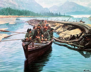
1850 View of Timber Raft on Lake Champlain -- TimberTitle/Content of Map: 1850 View of Timber Raft on Lake Champlain -- Timber Raft on Lake Champlain Cartographer: Hinton / Tallis Year/Place: 1850, London Size: 6.4 X 8.6 in. with vignettes This is a veSee Sold Price
Sold18TH C POWDER HORN WITH ENGRAVED MAP AND EAGLE,FRENCH CREST, POSSIBLY CANADIAN, DEPICTING GREAT LAKES REGION, IROQUOIS SETTLEMENTS, FORT TICONDEROGA & LAKE CHAMPLAIN, HEART SHAPED STOPPER, APPROXIMATELY 15" LONG.See Sold Price
SoldAdirondack, Lake Champlain & Lake George BookletsTurn of the Century. This lot includes a rare "Birch Bark of the Adirondacks" Booklet Dated 1887 with map.See Sold Price
SoldPeter S. Palmer History of Lake Champlain Frank F.Peter S. Palmer History of Lake Champlain Frank F. Lovell , N/D Notes with fold out map, VG, 3rd editionSee Sold Price
SoldOgdensburgh and Lake Champlain Railroad Co. #106174Incorp. New York founded in 1849 as the Northern Railroad .It was purchased in 1901 by the Rutland Railroad and became the Ogdensburg Division. #1166, I/U, 6%, $500 Income Mortgage Bond due 1920. IssuSee Sold Price
SoldOgdensburgh and Lake Champlain Railroad Co. #106175Incorp. New York founded in 1849 as the Northern Railroad .It was purchased in 1901 by the Rutland Railroad and became the Ogdensburg Division. #1638, I/U, 6%, $100 Income Mortgage Bond due 1920. IssuSee Sold Price
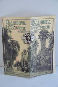
Los Angeles and Salt Lake RR California in Winter Brochure-October 1912JM Hobby Supply and Railroad Artifact Auctions4.4(126)See Sold PriceFeb 24, 2024
New York Central RR The Adirondacks Brochure 1916-1917JM Hobby Supply and Railroad Artifact Auctions4.4(126)See Sold PriceFeb 24, 2024
DEVINE c1856 Dr Salters Map Of Lake Huron Ontario Indian Lands etc. No. 7 ScarceLuis Porretta Fine Arts4.3(10)See Sold PriceMar 02, 2024
19thc Colton Map, Comparitive Size of Lakes & IslandsConnoisseur Auctions4(333)See Sold PriceFeb 24, 2024
1849 Mitchell School ATLAS 24 MAPS America Holy Land France Africa Egypt AsiaSchilb Antiquarian Rare Books4.8(421)See Sold PriceMar 31, 2024
1849 THE NEW-ENGLAND MERCANTILE UNIONNorth American Artifact Auctions4.6(182)See Sold PriceApr 20, 2024
[NEW YORK STATE]. Scrapbook of photographs of Lake George a...Potter & Potter Auctions4.6(539)See Sold PriceMar 07, 2024
Mort Kunstler Civil War Print Rogers Rangers on Lake Champlain Custom FramedMynt Auctions4.6(680)See Sold PriceFeb 29, 2024
GEORGE ANDREW CORLEY (DATES UNKNOWN) U.S. TEAM SKI TRYOUTS / MT. HOOD OREGON. 1939.Swann Auction Galleries4.4(65)See Sold PriceFeb 29, 2024
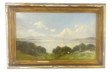
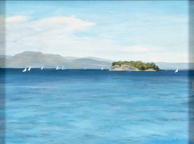
OIL/ CANVAS SGND J.B. BRISTOL "LAKE CHAMPLAIN... FROM LARRABEES POINT, VERMONT (JOHN BUNYON BRISTOLCarlsen Gallery, Inc.4.6(163)See Sold PriceMar 03, 2024
AFRICA. Map pre-dating much exploration. Mountains of Kong. SDUK 1851 oldJasper524.5(9.8k)See Sold PriceFeb 28, 2024
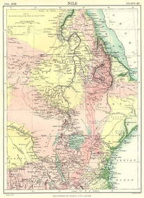
NILE VALLEY. Sudan Tanzania Ethiopia Uganda Lake Victoria. Britannica. 1898 mapJasper524.5(9.8k)See Sold PriceFeb 28, 2024
WESTERN AFRICA.Kong Mountains.Caravan routes.Slave Coast.TALLIS/RAPKIN 1849 mapJasper524.5(9.8k)See Sold PriceFeb 28, 2024
WEST AFRICA II. NIGERIA. Bight of Benin-Lake Chad. Yariba Houssa. SDUK 1851 mapJasper524.5(9.8k)See Sold PriceFeb 28, 2024
NIGERIA early explorers' routes. Lake Chad. Yariba Houssa Borgou SDUK 1844 mapJasper524.5(9.8k)See Sold PriceFeb 28, 2024
NIGERIA w/ early explorers' routes. Lake Chad Yariba Houssa Borgou.SDUK 1844 mapJasper524.5(9.8k)See Sold PriceFeb 28, 2024
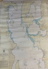
CHART: U.S LAKE SURVEYS/ LAKE CHAMPLAIN/ CUMBERLAND HEAD, NY and SAVAGE ISLAND, VT. TO FOUR BROTHERSChurchill Galleries3.7(213)See Sold PriceFeb 26, 2024
1849 Hand Colored Blair Map of World in HemispheresMatthew Bullock Auctioneers4.7(1.8k)See Sold PriceMar 02, 2024
1849 Orr & Co. Hand Colored Southern Germany MapMatthew Bullock Auctioneers4.7(1.8k)See Sold PriceMar 02, 2024


![[NEW YORK STATE]. Scrapbook of photographs of Lake George a... (1 of 5)](https://p1.liveauctioneers.com/928/318880/171361558_1_x.jpg?height=282&quality=70&version=1707501302)