ATLAS of ANTIENT GEOGRAPHY by SAMUEL BUTLER 1843John McInnis Auctioneers,LLC4.6(502)See Sold PriceFeb 24, 2024
18TH C. ANTIQUE MAP: FRENCH & INDIAN WAR, FRAMEDThomaston Place Auction Galleries4.4(386)See Sold PriceFeb 24, 2024
Rand McNally Railroad Map Cabinet w/ 21 Railroad MapsRail & Road Auctions4.6(165)See Sold PriceMar 08, 2024
Keith Haring - Ink on New York Map, Best Buddies, Inscribed, Signed, and DatedSapphire Auction Gallery4(67)See Sold PriceMar 02, 2024
LATE 17TH C. FRENCH MAP OF THE NEW WORLD BY ALEXIS-HUBERT JAILLOT (1632-1712)Thomaston Place Auction Galleries4.4(386)See Sold PriceFeb 24, 2024
Central Railroad of New Jersey Map of Sandy Hook Route-ca. 1903JM Hobby Supply and Railroad Artifact Auctions4.4(126)See Sold PriceFeb 24, 2024
Lot of Six Mixed Atlas Box Cars-HO Scale-New in BoxJM Hobby Supply and Railroad Artifact Auctions4.4(126)See Sold PriceFeb 25, 2024
Rand McNally/Santa Fe Railroad Map of Iowa-1912JM Hobby Supply and Railroad Artifact Auctions4.4(126)See Sold PriceFeb 24, 2024
NICOLAES VISSCHER (NETHERLANDS, 1618-1709) MAP OF THE NEW WORLDThomaston Place Auction Galleries4.4(386)See Sold PriceFeb 24, 2024
17TH C. WORLD MAP BY NICOLAES VISSCHER (NETHERLANDS, 1618-1709)Thomaston Place Auction Galleries4.4(386)See Sold PriceFeb 24, 2024
Lot of Six Mixed Atlas Cabooses-HO Scale-New in BoxJM Hobby Supply and Railroad Artifact Auctions4.4(126)See Sold PriceFeb 25, 2024
United Provinces Chili & Patagonia.Title/Content of Map: United Provinces Chili & Patagonia. Date Printed: 1835 Cartographer: Bradford, T.G. Size: 7.75X10 Shows all of southern South America. 76. Engraved by G.W. Boynton? Margins foxedSee Sold Price
Bolivia or Upper Peru. Chili. United Provinces of LaTITLE/CONTENT OF MAP: 'Bolivia, or Upper Peru; Chili and the United Provinces of South America, or La Plata' The top image on the right hand side shows the entire map. To view a close up of the map shSee Sold Price
Geograph. Instituts: United Provinces of South AmericaThe United Provinces of South America map from the scarce German edition of the Carey & Lea Geographical, Statistical, and Historical Atlas. The short-lived United Provinces included northern Chili, nSee Sold Price
SoldHuntington, South America, 1833An original map of South America published in 1833. It is of special interest in that it shows Patagonia as a separate country and labels what is now Argentina and Uruguay as 'United Provinces.' Size:See Sold Price
SoldMap of Seven United Provinces, 1836Original engraving by Samuel Walker, 1836. Dimensions: 12” x 16” No Reserve Buyer pays shipping - ships from Ocean View, DESee Sold Price
SoldWorld Coins - Netherlands - United Provinces -Dated 1562 AD. Trade coinage, early type. Obv: standing knight dividing date with CONCORDIA RES-P-AR CRES GEL legend. Rev: ornate tablet with MO ORD / PROVIN / FOEDER / BELG AD / LEG IMP legend in fivSee Sold Price
SoldH. Moll, 1710, Map of United ProvincesDedicated to the Right Honorable Charles Lord Viscount Townshend. Constructed in 2 panels, hand colored. Tears to top and bottom edges. Tear at top at middle fold, does not impact map completion. WateSee Sold Price
Sold[Holland] The Seven United Provinces. From the bestTitle: [Holland] The Seven United Provinces. From the best authorities. Publication Date: c1789 Size: 7.3Height - 8.5Width Additional Information: Plate XII. From an unidentified English atlas ReserveSee Sold Price
SoldWorld Coins - Netherlands - United Provinces -Dated 1651 AD. Trade coinage, early type. Obv: standing knight dividing date with CONCORDIA RES-P-AR CRES GEL legend. Rev: ornate tablet with MO ORD / PROVIN / FOEDER / BELG AD / LEG IMP legend in fivSee Sold Price
Sold1783 Folding Map of Seven United ProvincesA New Map of the Seven United Provinces, by J. Bayley, printed at London in 1783, published by Harrison and Co. Folding map measuring 16 x 10". Fine condition. Reserve: $15.00 Shipping: Domestic: FlatSee Sold Price
SoldSeven United Provinces With The Austrian, French &Title: Seven United Provinces With The Austrian, French & Dutch Netherlands. Publication Date: c1763 Cartographer: JEFFERYS, T. Size: 7.1Height - 7.1Width Reserve: $45.00 Shipping: Domestic: Flat-rSee Sold Price
SoldTthe Seven United Provinces, & Netherlands, from TheTitle: Tthe Seven United Provinces, & Netherlands, from The Latest Authorities Publication Date: 1790 Cartographer: CONDER, T. Publisher: C. DILLY Size: 7.25Height - 8.5Width Additional Information: ISee Sold Price
Sayer: Antique Map of Dutch United Provinces, 1772Map: Seven [Dutch] United Provinces With Their Roads and Divisions. Publication Date: 1772-03-02 Cartographer: SAYER, ROBERT Publisher: ROBERT SAYER Size: Quarto – 19.30 H x 23.25 W Inches DissectedSee Sold Price
SoldSilver coin from the United Provinces of the Río de laSilver coin from the United Provinces of the Río de la Plata, year 1832.See Sold Price
SoldRademaker's Views of the United Provinces 1725Title: Collection, De Vues & Monumens Anciens des Sept Provinces Unies Author:Rademaker, Abraham Description:Vol. 1 only (of 2). [viii] pp, 150 copperplate engravings with descriptive captions in DutcSee Sold Price
SoldMoll (H) A map of Chili, Patagonia, La PlataMoll (Herman) A map of Chili, Patagonia, La Plata and ye south part of Brasil.from Atocama and Cape of St Vincent to Cape Horn, engraved map, 280 x 210mm., one central horizontal fold, c.1736See Sold Price
c.1800 American Made Map, The Seven United Provinces,The Seven United Provinces. ( Europe / Netherlands ). Issued c.1800 New York. Engraved for Payne's Geography, Published by J. Low. Very early American produced map of the Netherlands. EngravSee Sold Price
Seven [Dutch] United Provinces With Their Roads andTitle: Seven [Dutch] United Provinces With Their Roads and Divisions. Cartographer: SAYER, ROBERT Publication Date: March 2, 1772 Publisher: ROBERT SAYER Size: Height: 19.3 Width: 23.25 Dissected, linSee Sold Price
SoldDunn (Samuel) The Seven United ProvincesDunn (Samuel) The Seven United Provinces,showing the Netherlands, the North Sea and part of England and France, engraved map with original outline hand-colouring, 305 x 435mm., small repair toSee Sold Price
1783 Map of the Seven United ProvincesA New Map of the Seven United Provinces, by J. Bayley, printed at London in 1783, published by Harrison and Co. Folding map measuring 16 x 10". Fine condition. Please note that this lot has a confidenSee Sold Price
Seven United Provinces, With Their Roads and DivisionsTitle: Seven United Provinces, With Their Roads and Divisions Publication Date: 1780-03-02 Cartographer: SAYER, ROBERT Publisher: ROBERT SAYER Size: 18.6X22.25 Stained upper margin. Map 13 from SayerSee Sold Price
Moll (H.) United Provinces, or NetherlandsMoll (Herman) A New and Exact Map of the United Provinces, or Netherlands etc., engraved map of the Netherlands, on 2 sheets, joined, with outline hand-colouring, inset chart of the North Sea,See Sold Price
SoldENGLISH MAP OF THE UNITED PROVINCES EMANUEL BOWENENGLISH MAP OF THE UNITED PROVINCES, EMANUEL BOWEN, H 14" W 17":Inscribed at the upper right, "A New and Correct Map of the Seven United Provinces, Drawn from the most Approved Maps and Charts: the WhSee Sold Price
c.1800 American Made Map, The Seven United Provinces,The Seven United Provinces. ( Europe / Netherlands ). Issued c.1800 New York. Engraved for Payne's Geography, Published by J. Low. Very early American produced map of the Netherlands. Engraved, possibSee Sold Price
RICHARD BALL SPENCER (United Kingdom, 1812-1897), Portrait of the Mandarin., Oil on canvas, 19" xEldred's4.7(409)See Sold PriceFeb 28, 2024
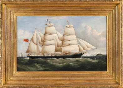
JOHN WARD OF HULL (United Kingdom, 1798-1849), "A Frigate Offshore"., Oil on canvas, 19.5" x 28".Eldred's4.7(409)See Sold PriceFeb 28, 2024
JAMES MEADOWS, SR. (United Kingdom, 1798-1864), Busy scene of a Dutch harbor., Oil on canvas, 30" xEldred's4.7(409)See Sold PriceFeb 27, 2024
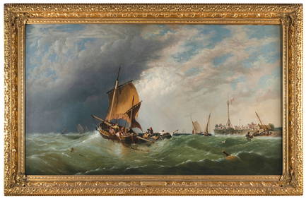
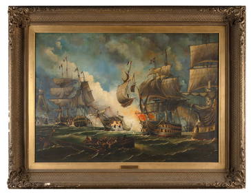
WILLIAM GRIFFIN (United Kingdom, 19th Century), "Battle of the Glorious 1st June"., Oil on canvas,Eldred's4.7(409)See Sold PriceFeb 27, 2024
"THE PRESIDENTS OF THE UNITED STATES" N. CURRIERJohn McInnis Auctioneers,LLC4.6(502)See Sold PriceFeb 25, 2024
United States 1c 1857 issue on cover Lexington KT, stamp cur at bottomBazaar of Persia4.3(23)See Sold PriceFeb 24, 2024
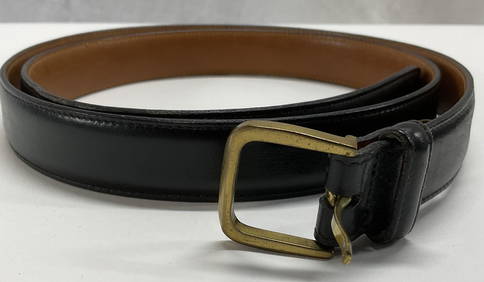
TRAFALGAR Black Handmade French Box Calf BeltThe Benefit Shop Foundation Inc.4.3(2.9k)See Sold PriceMar 06, 2024
Rare Mid-Century Modern Egyptian Revival Ebonized "Thebes" Stool by Liberty & Company UnitedBidhaus4.3(747)See Sold PriceFeb 26, 2024
Cooke, George 1801 Antique Map. United States of AmericaAlbion Auctions4.6(336)See Sold PriceMar 01, 2024
Rare 19thc Colton Map, Argentine Republic, Chile, Uruguay, PataguayConnoisseur Auctions4(333)See Sold PriceMar 16, 2024
Set of 4 Maps - Netherlands - Seven United Provinces - Germany - Sweden, Denmark, Norway, FinlandProverde Auctions4.3(3)See Sold PriceFeb 28, 2024
Map of the United Provinces of the Netherlands, 1798 PrintAntiques Online Auctions4.6(407)See Sold PriceMar 14, 2024
Kikuo Saito (JAPANESE / UNITED STATES / NEW YORK, 1939 - 2016) large oil painting on canvas havingJoshua Kodner4.2(386)See Sold PriceMar 09, 2024


![[Holland] The Seven United Provinces. From the best (1 of 1)](https://p1.liveauctioneers.com/5584/139429/70692708_1_x.jpg?height=282&quality=70&version=1554845662)


![Seven [Dutch] United Provinces With Their Roads and (1 of 5)](https://p1.liveauctioneers.com/5584/166564/84047857_1_x.jpg?height=282&quality=70&version=1587562110)