Moll (H.) United Provinces, or NetherlandsMoll (Herman) A New and Exact Map of the United Provinces, or Netherlands etc., engraved map of the Netherlands, on 2 sheets, joined, with outline hand-colouring, inset chart of the North Sea,See Sold Price
SoldAntique Maps, Netherlands, England, Chinon, EuropeA group of five smaller framed antique maps. Comprised of 1) The United Provinces or Netherlands, H. Moll Geographer, 2) Bowles Post Chase Companion, London to Newmarket, etc. Published 1782, 3) ChinoSee Sold Price
SoldMOLL - Map of the United Provinces, or NetherlandMAPS. - MOLL, Herman. A New and Exact map of the United Provinces, or Netherlands.London: printed for H. Moll, D. Midwinter and T. Bowles, [circa 1720]. Engraved map (sheet size: 648x1037 mm),See Sold Price
SoldH. Moll, 1710, Map of United ProvincesDedicated to the Right Honorable Charles Lord Viscount Townshend. Constructed in 2 panels, hand colored. Tears to top and bottom edges. Tear at top at middle fold, does not impact map completion. WateSee Sold Price
SoldGrp: 3 Maps of EuropeGroup of three maps of Europe. Includes one hand colored map of the Netherlands by Herman Moll (1654-1732), "A New Map of the United Provinces of Netherlands &c." London: Herman Moll, ca. 1701; one DuSee Sold Price
H. Moll, circa 1715, Map of FlandersAlso know as Austrian Netherlands. Les Provinces des Pays-Bas Catholiques. Dedicated to His Grace Iames Duke of Ormond. Major tears to bottom of map. Hand colored. Tears to bottom left includes loss iSee Sold Price
SoldThree 18th and 19th c. maps, Ireland and UK(Lot of 3) Framed 18th and 19th century maps, ''Buckingham Shire'' by Robert Morden, ''Seven United Provinces'' by Eman Bowen, and ''Ireland'' by Herman Moll 1732, largest overall: 19.5''h x 22''wSee Sold Price
SoldMoll LES PROVINCES DES PAYS-BAS CATHOLIQUES C1715Details: MOLL, Herman (fl. 1678-1732). Les Provinces Des Pays-Bas Catholiques ou A Most Exact Map of Flanders or Austrian Netherlands & c. London: "Sold by H. Moll over against Devereux Court ... D.See Sold Price
SoldTthe Seven United Provinces, & Netherlands, from TheTitle: Tthe Seven United Provinces, & Netherlands, from The Latest Authorities Publication Date: 1790 Cartographer: CONDER, T. Publisher: C. DILLY Size: 7.25Height - 8.5Width Additional Information: ISee Sold Price
Seven United Provinces, & Netherlands, from The LatestTitle/Content of Map: Seven United Provinces, & Netherlands, from The Latest Authorities. Date: 1791 Cartographer: CONDER, T. sculpt. Size: 7.3Height - 8.5Width Publisher: R. WILKINSON Illustration maSee Sold Price
Seven United Provinces, & Netherlands, from The LatestTitle: Seven United Provinces, & Netherlands, from The Latest Authorities. Cartographer: CONDER, T. sculpt. Publisher: R. WILKINSON Brief Description: Light offsetting. Height X Width: 7.3x 8.5 ReservSee Sold Price
Antique Map of Europe - The Seven United Provinces - Netherlands - BelgiumTitle: Antique Map of Europe - The Seven United Provinces - Netherlands - Belgium Date: 1806 Material: Paper Dimensions: 10” x 8” inches / 25 cm x 21 cm Descritpion: Antique map of The SevSee Sold Price
c.1800 American Made Map, The Seven United Provinces,The Seven United Provinces. ( Europe / Netherlands ). Issued c.1800 New York. Engraved for Payne's Geography, Published by J. Low. Very early American produced map of the Netherlands. EngravSee Sold Price
c.1800 American Made Map, The Seven United Provinces,The Seven United Provinces. ( Europe / Netherlands ). Issued c.1800 New York. Engraved for Payne's Geography, Published by J. Low. Very early American produced map of the Netherlands. Engraved, possibSee Sold Price
c.1800 American Made Map, The Seven United Provinces,The Seven United Provinces. ( Europe / Netherlands ). Issued c.1800 New York. Engraved for Payne's Geography, Published by J. Low. Very early American produced map of the Netherlands. Engraved,See Sold Price
c.1800 American Made Map, The Seven United Provinces,The Seven United Provinces. ( Europe / Netherlands ). Issued c.1800 New York. Engraved for Payne's Geography, Published by J. Low. Very early American produced map of the Netherlands. Engraved,See Sold Price
c.1800 American Made Map, The Seven United Provinces,The Seven United Provinces. ( Europe / Netherlands ). Issued c.1800 New York. Engraved for Payne's Geography, Published by J. Low. Very early American produced map of the Netherlands. Engraved,See Sold Price
SoldBarlow 1807 Pair of Maps of The Netherlands, Holland"The Severn United Provinces" and "Netherlands from the best Authorities" Copper Engraved Map Published 1807 by Brightly & Kinnersley, Bungay, England for "A General View of the World, Geographical, HSee Sold Price
SoldWalker, John 1795 Pair of Maps of The Netherlands"The Severn United Provinces" and "Netherlands" Copper Engraved Maps Published 1795, London for "Elements of Geography, and of Natural and Civil History" by John Walker. Centre fold as published. PapeSee Sold Price
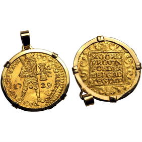
SoldWorld Coins - Netherlands - United Provinces -Dated 1562 AD. Trade coinage, early type. Obv: standing knight dividing date with CONCORDIA RES-P-AR CRES GEL legend. Rev: ornate tablet with MO ORD / PROVIN / FOEDER / BELG AD / LEG IMP legend in fivSee Sold Price
SoldWorld Coins - Netherlands - United Provinces -Dated 1651 AD. Trade coinage, early type. Obv: standing knight dividing date with CONCORDIA RES-P-AR CRES GEL legend. Rev: ornate tablet with MO ORD / PROVIN / FOEDER / BELG AD / LEG IMP legend in fivSee Sold Price
Map of United Provinces of the Netherlands. 1809.Print from steel engraving titled „Provinces unies des Pays Bas“.Author/compiler – M. Barthelemy.Engraved unknown.Notes: After restauration.From „Methode abregee et facile pour apprenre la geoSee Sold Price
Map of United Provinces of the Netherlands. 1809.Print from steel engraving titled „Provinces unies des Pays Bas“.Author/compiler – M. Barthelemy.Engraved unknown.Notes: After restauration.From „Methode abregee et facile pour apprenre la geoSee Sold Price
SoldMAP, UNITED PROVINCES OF THE NETHERLANDSENGRAVED MAP, UNITED PROVINCES OF THE NETHERLANDS, 1702, FRAMED & GLAZED. PLATE 6 1/4 X 20 3/4"See Sold Price
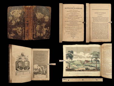
1816 Napoleon 1ed EARLY Battle at Waterloo Account Napoleonic Wars FranceSchilb Antiquarian Rare Books4.8(421)See Sold PriceMar 10, 2024
US PRESIDENT GEORGE H W BUSH VP & FIRST LADY AUTOGRAPHSOmnia Auctions4.7(324)See Sold PriceFeb 26, 2024
Hans BAYENS (1924-2003) "The Old lady with broom" Bronze.GOLDFIELD AUCTION4.3(32)See Sold PriceMar 02, 2024
USA Naval Station Military Cover to Pensacola FL USA John H BrownMynt Auctions4.6(680)See Sold PriceFeb 25, 2024
A 19thC Windsor chair with a double bow back rest and elm seat raised on turned tapering legs unitedClaydon Auctioneers Ltd4.3(125)See Sold PriceFeb 26, 2024
A late Georgian Windsor chair with a fanned back splat, a shaped seat and raised on turned taperingClaydon Auctioneers Ltd4.3(125)See Sold PriceFeb 26, 2024
A Georgian library chair with unusual upholstered arms and raised on straight legs united by aClaydon Auctioneers Ltd4.3(125)See Sold PriceFeb 26, 2024
A mid 19thC Windsor chair with a double bow back, pierced back splat and swept arms above a shapedClaydon Auctioneers Ltd4.3(125)See Sold PriceFeb 26, 2024
A late 19thC / early 20thC lathe back Windsor chair, with a bowed top rail, slatted back slats, aClaydon Auctioneers Ltd4.3(125)See Sold PriceFeb 26, 2024
A late 19thC lathe back Windsor chair with swept arms above a shaped elm seat and raised on turnedClaydon Auctioneers Ltd4.3(125)See Sold PriceFeb 26, 2024
A 19thC lathe back nursing chair with a shaped elm seat raised on four turned tapering legs unitedClaydon Auctioneers Ltd4.3(125)See Sold PriceFeb 26, 2024
Mid-Century Modern Brutalist Chandelier / Pendant by Tom Greene, Patinated BrassJasper524.5(9.8k)See Sold PriceFeb 28, 2024
Birds of American, Hardcover Book by T. Gilbert PearsonLion and Unicorn4.7(1.8k)See Sold PriceMar 03, 2024
Set of 4 Maps - Netherlands - Seven United Provinces - Germany - Sweden, Denmark, Norway, FinlandProverde Auctions4.3(3)See Sold PriceFeb 28, 2024
Map of the United Provinces of the Netherlands, 1798 PrintAntiques Online Auctions4.6(407)See Sold PriceMar 14, 2024
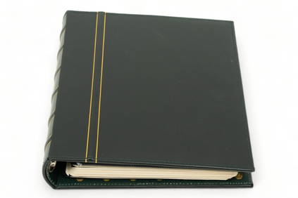
Stamp Collection Album, United States & World Stamps, H 11.75" W 2.25" Depth 10.75"DuMouchelles4.6(825)See Sold PriceMar 14, 2024
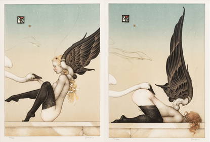
Michael Parkes (American, B. 1944) Lithographs in Colors on Wove Paper, 1996, "Almost FallenDuMouchelles4.6(825)See Sold PriceMar 15, 2024