ATLAS of ANTIENT GEOGRAPHY by SAMUEL BUTLER 1843John McInnis Auctioneers,LLC4.5(505)See Sold PriceFeb 24, 2024
18TH C. ANTIQUE MAP: FRENCH & INDIAN WAR, FRAMEDThomaston Place Auction Galleries4.4(393)See Sold PriceFeb 24, 2024
Rand McNally Railroad Map Cabinet w/ 21 Railroad MapsRail & Road Auctions4.6(165)See Sold PriceMar 08, 2024
Keith Haring - Ink on New York Map, Best Buddies, Inscribed, Signed, and DatedSapphire Auction Gallery4.1(67)See Sold PriceMar 02, 2024
LATE 17TH C. FRENCH MAP OF THE NEW WORLD BY ALEXIS-HUBERT JAILLOT (1632-1712)Thomaston Place Auction Galleries4.4(393)See Sold PriceFeb 24, 2024
Central Railroad of New Jersey Map of Sandy Hook Route-ca. 1903JM Hobby Supply and Railroad Artifact Auctions4.4(127)See Sold PriceFeb 24, 2024
Lot of Six Mixed Atlas Box Cars-HO Scale-New in BoxJM Hobby Supply and Railroad Artifact Auctions4.4(127)See Sold PriceFeb 25, 2024
Rand McNally/Santa Fe Railroad Map of Iowa-1912JM Hobby Supply and Railroad Artifact Auctions4.4(127)See Sold PriceFeb 24, 2024
NICOLAES VISSCHER (NETHERLANDS, 1618-1709) MAP OF THE NEW WORLDThomaston Place Auction Galleries4.4(393)See Sold PriceFeb 24, 2024
17TH C. WORLD MAP BY NICOLAES VISSCHER (NETHERLANDS, 1618-1709)Thomaston Place Auction Galleries4.4(393)See Sold PriceFeb 24, 2024
Lot of Six Mixed Atlas Cabooses-HO Scale-New in BoxJM Hobby Supply and Railroad Artifact Auctions4.4(127)See Sold PriceFeb 25, 2024
Map showing railroads of Britain 1845Heading: Author: Wyld, James Title: A New Map of Great Britain Particularly Shewing the Inland Navigation by the Canals; and Principal Rivers, with the Railways, Finished and in Progress, and the PriSee Sold Price
Black: England And Wales.Map: England And Wales Maker: Adam & Charles Black, Sidney Hall Publishing Date: 1847 Size: Folio - 32.00 H X 21.75 inches Very large two sheet map of great britain showing railroads and highways, topSee Sold Price
England And Wales.Publication Date: 1847 Title: England And Wales. Cartographer: Sidney Hall Publisher: Adam & Charles Black Height: 32 Width: 21.75 Very large two sheet map of Great Britain showing railroads and highwSee Sold Price
Sold1845 Dugdale Great Britain Illustrated MAPS Scenery1845 Dugdale Great Britain Illustrated MAPS Scenery Churches CASTLES Railroads “Curiosities of Great Britain” by Thomas Dugdale and cartographic publisher John Tallis, encompasses a comprehensiveSee Sold Price
Sold1845 New Pocket Map of New York, Pasturnell, Show1845 New Pocket Map of New York, Pasturnell, Showing canals and railroads-- Dimensions: ---See Sold Price
Sold1845 New Pocket Map of New York, Pasturnell, Show1845 New Pocket Map of New York, Pasturnell, Showing canals and railroads-- Dimensions: --- US Shipping charge: $20See Sold Price
Skeleton Map Showing Railroads, United States GPO, 1849"Skeleton Map Showing the Rail Roads Completed and in progress in the United States and those projected through the Public Lands and their connection with the principal Harbours on the Lakes and on thSee Sold Price
SoldAmerican Oak Map Case on WheelsAmerican Oak Map Case on Wheels c.1890 twelve drawer case, each having a page from Rand McNally's New Commercial Atlas of America pasted inside; Midwestern states maps showing railroads and steamshipSee Sold Price
Untitled. MexicoTitle: Untitled. Mexico Publication Date: 1890 Cartographer: RAND, MCNALLY & CO. Publisher: JOHN B. ALDEN Size: 12.75Height - 19.5Width 106, 107. Mexico national map showing railroads. On reverse, WesSee Sold Price
UtahPublication Date: 1885 Title: Utah Cartographer: CRAM, GEO. F. Publisher: CRAM, GEO. F. Height: 21.8 Width: 15.5 Map showing railroads (7) separately colored with table naming each. Other details inclSee Sold Price
UtahTitle/Content of Map: Utah Cartographer: CRAM, GEO. F. Date: 1885 Publisher: CRAM, GEO. F. Size: 21.8Height - 15.5Width Map showing railroads (7) separately colored with table naming each. Other detaiSee Sold Price
Map Showing the Railroad and Canal Lines Used in theReserve Reduced! Title: Map Showing the Railroad and Canal Lines Used in the Determination of Elevations Publication Date: 1874 Cartographer: GARDNER, JAMES T. Publisher: U.S.G.S. Size (inches): H15 -See Sold Price
SoldTopographical map of Colorado Springs & Cripple CreekMap showing the railroads in Central Colorado. Include Denver, Cripple Creek, Colorado Springs, Canon City, Pueblo, etc. Close up of the Colorado Springs and Cripple Creek District Railroad. May 1900.See Sold Price
SoldAntique Map, "LaSalle County, Illinois",Antique Map, "LaSalle County, Illinois",Thompson Bros, Elgin, Illinois, 1870, 27 engravings of local landmarks form a border for this highly detailed map showing townships, railroads and even propertySee Sold Price
United StatesTitle: United States Date: c1930 Cartographer: ANONYMOUS Publisher: HOTCHKISS MAP CO. Size: 20.3Height - 32.25Width Large uncolored pocket map showing all railroads. Folds into orange wrappers readingSee Sold Price
1884 Rand McNally Map of Kentucky -- KentuckyTitle/Content of Map: 1884 Rand McNally Map of Kentucky -- Kentucky Date: 1884, Chicago Cartographer: Rand McNally Size: 6 X 10.5 in. A nice detailed map, showing towns, railroads, and waterways. TheSee Sold Price
SoldEurope.- Ruscelli (Girolamo) - Tabula Europae 1,engraved map showing Ireland, Britain and part of Northern Europe, hand coloured, 195 x 250mm, V enice, c.1561.See Sold Price
Asher & Adams' Kentucky & TennesseeTitle: Asher & Adams' Kentucky & Tennessee Publication Date: 1872 Cartographer: ASHER & ADAMS Publisher: ASHER & ADAMSSize: 16Height - 23.8Width Large scale atlas map showing all railroads. The New MeSee Sold Price
Commercial and Industrial Map of the United StatesTitle: Commercial and Industrial Map of the United States Publication Date: 1875 Cartographer: HARPER & BROTHERS Publisher: HARPER & BROTHERSSize: 8.8Height - 16Width Map showing all railroads in red.See Sold Price
SoldRailroad Map Shows Mississippi River to Pacific Route11"x 38" geological map showing a railroad surveyed route from the Mississippi River to the Pacific Ocean. Map has some frayed edges, but is still in useful decorative condition. Please see photos forSee Sold Price
Johnson's SwitzerlandTitle/Content of Map: Johnson's Switzerland Cartographer: JOHNSON AND WARD Date: 1863 Publisher: JOHNSON AND WARD Size: 11.3Height - 14Width Detailed map showing topography, railroad, common roads, prSee Sold Price
Johnson's SwitzerlandTitle/Content of Map: Johnson's Switzerland Date: 1863 Cartographer: JOHNSON AND WARD Publisher: JOHNSON AND WARD Size: 11.3Height - 14Width Detailed map showing topography, railroad, common roads, prSee Sold Price
Sold1886 Mont., Idaho, Wyoming County/Twp. mapExcellent two-page map showing towns, townships, railroads, topography, Indian tribes and reservations (northwest MT) depiction, military reserve, Yellowstone National Park, rivers, lakes. From the 18See Sold Price
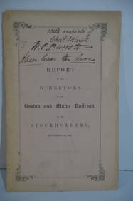
Boston and Maine RR Annual Report-September 12, 1849JM Hobby Supply and Railroad Artifact Auctions4.4(127)See Sold PriceFeb 24, 2024
Lake Superior and Mississippi River RR 1869 Seven Percent Bonds Book/Report-1869JM Hobby Supply and Railroad Artifact Auctions4.4(127)See Sold PriceFeb 24, 2024
Crams Railroad Map of New York-1881JM Hobby Supply and Railroad Artifact Auctions4.4(127)See Sold PriceFeb 24, 2024
Rand McNally Railroad Map of Arizona-1909JM Hobby Supply and Railroad Artifact Auctions4.4(127)See Sold PriceFeb 24, 2024
Union Pacific RR Map of the United States-1926JM Hobby Supply and Railroad Artifact Auctions4.4(127)See Sold PriceFeb 24, 2024
Union Pacific RR Across The Continent West From Omaha, NE Book-April 2, 1868JM Hobby Supply and Railroad Artifact Auctions4.4(127)See Sold PriceFeb 24, 2024
Group of New York Central Railroad Paper - Rule Books, Employee Timetables, Stationary, Log Books,Rail & Road Auctions4.6(165)See Sold PriceMar 07, 2024
Pair of Early Railroad Maps - 1862 Pittsburgh, Ft. Wayne & Chicago Railway and 1873 PennsylvaniaRail & Road Auctions4.6(165)See Sold PriceMar 07, 2024
Fred Harvey Railroad Souvenir Playing Cards - Indians and Train Smoke and Indians of the SouthwestRail & Road Auctions4.6(165)See Sold PriceMar 08, 2024
Central Africa. Map showing great forest traversed by Mr Stanley, 1890Jasper524.5(9.9k)See Sold PriceFeb 28, 2024