SoldENGLISH STITCHWORK - Schoolgirl's Oval "Map of EnglandENGLISH STITCHWORK - Schoolgirl's Oval "Map of England & Wales", signed "Elizabeth Middleton" and dated 1792. In the original black & gold frame, glazed. From the estate of Brooke Astor. OS: 23" x 20See Sold Price
SoldENGLISH STITCHWORK - Schoolgirl's Oval "Map of EnglandENGLISH STITCHWORK - Schoolgirl's Oval "Map of England & Wales", signed "Elizabeth Middleton" and dated 1792. In the original black & gold frame, glazed. From the estate of Brooke Astor. OS: 23" x 20See Sold Price
SoldA Wedgwood black basalt Bacchus cup, with vine chaplet,A Wedgwood black basalt Bacchus cup, with vine chaplet, 10cm high, a similar black basalt jug, moulded with the emblems of England, Scotland, Wales and Northern Ireland within stiff leaves, angular haSee Sold Price
EDWARD VII, King of England (1841-1910).* EDWARD VII, King of England (1841-1910). Autograph letter signed ("Albert Edward"), as Prince of Wales, to Mrs. Hope. Sandringham, Norfolk, 12 April 1884. 3 pages, 8vo, on black-bordered stationery,See Sold Price
SoldAutographed Souvenir Picture Edward VIIIBlack and white image of Edward VIII King of England, 1936. With printing below, "Edward H.R.H. Edward Albert Christian George Patrick David of Windsor, Prince of Wales, born June 23, 1894. This souveSee Sold Price
Sold1885 Cathedral Churches England & Wales Illustrated1885 Cathedral Churches England & Wales Illustrated Gothic Architecture BEAUTY Main author: Bonney, T. G (edit.) Title: The Cathedral churches of England and Wales : descriptive, historical, pictorialSee Sold Price
Sold1814 ATLAS Maps of England & Wales Scotland Color Nav1814 ATLAS Maps of England & Wales Scotland Color Navigation Travel John Cary An incredible atlas consisting of 42 color maps of Great Britain by John Cary. The atlas covers cities in England, Wales,See Sold Price
Sold1798 1ed Cary ROADS New Itinerary England Wales1798 1ed Cary ROADS New Itinerary England Wales Topography Atlas Travel Guide John Cary was a famous English cartographer from the 18th-century. Cary gained his reputation as a map maker from his workSee Sold Price
Bowen: Antique Map of England & Wales, 1747Map: 1747 Bowen Map of England and Wales -- A New and Very Accurate Map of South Britain or England and Wales... Cartographer: E Bowen Year / Place: 1847 c., London Map Dimensions: 15.5 X 16.5 in. ConSee Sold Price
SoldRARE ANTIQUE 1796 NEEDLEPOINT SAMPLER MAP OF ENGLAND WALESRARE ANTIQUE 1796 NEEDLEPOINT SAMPLER MAP OF ENGLAND WALES ——MEASURES APPROXIMATELY —21"X22"——All items Located in Hollywood Florida Warehouse. Thank you for your inquirySee Sold Price
SoldCary, John 1801 Map of England & WalesHand Colored Copper Engraved Map Published 1801, London for "The Field of Mars" Folds as issued. Paper Size: 10.5 x 8 inch (27 x 21cm) Some margin toning. A couple of tine margin splits on folds. OtheSee Sold Price
SoldFenning & Collyer 1765 Map of England & WalesCopper Engraved Map Published 1764-65, London for "A New System of Geography: or, A General Description of the World" by Daniel Fenning & Joseph Collyer. Maps by G. Rollos, J. Gibson and others, mostlSee Sold Price
SoldJEANLOUP SIEFF - Lady in Black, England 1964Artist: JEANLOUP SIEFF Print Title: Lady in Black, England 1964 Medium: Sheet-Fed Gravure Printing Date: 1980's Printed in France Image Size approx: 5.75 x 8.75 inches Jeanloup Sieff (1933-2000) was aSee Sold Price
SoldENGLAND & WALES. London Newcastle Doncaster racesTITLE/CONTENT OF MAP: 'England and Wales' Vignettes: London; Entrance to Portsmouth Harbour; Newcastle-upon-Tyne; Fox hunting; Sunderland Bridge; Oxford; The grand stand on the race ground, DoncasterSee Sold Price
SoldKinckelbach 1592 Map of England & WalesDESCRIPTION: Map by Quad von Kinckelbach depicts England and Wales based off an earlier map by Ortelius. Conservation framed. MEASUREMENTS: Map 7" high x 10" wide; overall with frame 13-3/4" high x 17See Sold Price
Sold'Walker's tour through England & Wales, a new'Walker's tour through England & Wales, a new geographical pastime', published by William Darton, comprising fold-out map in cardboard sleeve, and counters in original box,See Sold Price
SoldCOLTAN'S MAP OF ENGLAND & WALESHand-colored 19th century lithograph. Published by Johnson and Browning. With center fold. As published. Dimensions: (Frame) H 24" x W 26", (Sight) H 25" x W 17" Condition: Age toning and printing offSee Sold Price
SoldBritish Isles: C England Wales Scotland Ireland MapBritish Isles: Counties. England Wales Scotland Ireland. Tallis/rapkin 1851 Map. Vignettes: London; Edinburgh; Dublin. Approx 36.5 x 26.5cm, 14.5 x 10.25 inches (Large). Antique engraved map by J RapkSee Sold Price
SoldCary, John 1812 Large Hand Col Map of England & Wales"A New Map of England and Wales. Adapted to Cary's New Itinerary" Hand Coloured Copper Engraved Map Published 1812, London for "Cary's Traveller's Companion" by John Cary. Paper Size: 19 x 15 inch (48See Sold Price
SoldGuthrie, William 1790 Antique Map. England & WalesCopper Engraved Map Published 1790, London for "A New Geographical, Historical and Commercial Grammar..." by William Guthrie. The maps are by John Senex, Thomas Kitchin and others. Folds as issued. EaSee Sold Price
SoldWalker, John 1815 Antique Map of England & WalesCopper Plate Published 1815, London for "The Universal Gazetteer: Being a Concise Description" [Walker's Geography] by John Walker. Folds as issued. Paper Size: 10 x 8 inch (25 x 20cm) Minor toning/ofSee Sold Price
SoldWalker, John 1795 Pair Maps of Scotland, England, WalesCopper Engraved Maps Published 1795, London for "Elements of Geography, and of Natural and Civil History" by John Walker. Centre fold as published. Paper Size: 10 x 8.5 inch (26 x 22cm) Minor toning aSee Sold Price
Cary: Large Map of England, Wales, Scotland, 1796Map: Cary’s reduction of his Large Map of England and Wales, with part of Scotland; Publication Date: 1796-02-20 Maker: John Cary, John Cary Publisher: John Cary Size: Elephant Folio – 29.3 H x 24See Sold Price
SoldSpeed (John) England, Wales, Scotland and IrelandSpeed (John) England, Wales, Scotland and Ireland Described,engraved pictorial title and 63 maps, including 2 folding of the British Isles and Yorkshire, by Pieter van den Keere., some ff. triSee Sold Price
OGILVY & BOWEN c1736 Original Map of Oxfordshire Berkshire Etc.Luis Porretta Fine Arts4.3(10)See Sold PriceMar 02, 2024
Numismatic Books - Boyne - Tokens Issued in the Seventeenth Century in England, Wales, and IrelandTimeLine Auctions Ltd.4.5(183)See Sold PriceMar 09, 2024
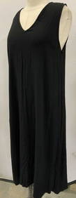
GHOST ENGLAND Black Summer Sleeveless DressThe Benefit Shop Foundation Inc.4.3(2.9k)See Sold PriceFeb 28, 2024
1861 ARCHITECTURE 1ed Handbook to Cathedrals England 100+ Full Page EngravingsSchilb Antiquarian Rare Books4.8(421)See Sold PriceMar 31, 2024
1939 Argentina Airmail Cover Buenos Aires to Mold North Wales EnglandMynt Auctions4.6(680)See Sold PriceFeb 26, 2024
[ENGLISH REFORMATION]. An Inventory of the Plate Belonging ...Potter & Potter Auctions4.6(539)See Sold PriceMar 07, 2024
Books: A quantity of assorted books on the subject of Women, to include The Life of Catherine BoothClaydon Auctioneers Ltd4.3(125)See Sold PriceFeb 26, 2024
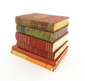
Book: The Romantic and Picturesque Scenery of England and Wales, by P. J. Loutherbourg. ReproducedClaydon Auctioneers Ltd4.3(125)See Sold PriceFeb 26, 2024
Late 18th century map of England and Wales sampler and two printsFellows4.3(159)See Sold PriceMar 05, 2024
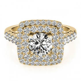
2.3 ctw Certified VS/SI Diamond Halo Ring 18k Yellow GoldPacific Global Auction3.9(272)See Sold PriceJul 27, 2024


![[ENGLISH REFORMATION]. An Inventory of the Plate Belonging ... (1 of 2)](https://p1.liveauctioneers.com/928/318880/171360970_1_x.jpg?height=282&quality=70&version=1707501302)