ATLAS of ANTIENT GEOGRAPHY by SAMUEL BUTLER 1843John McInnis Auctioneers,LLC4.5(505)See Sold PriceFeb 24, 2024
18TH C. ANTIQUE MAP: FRENCH & INDIAN WAR, FRAMEDThomaston Place Auction Galleries4.4(394)See Sold PriceFeb 24, 2024
Rand McNally Railroad Map Cabinet w/ 21 Railroad MapsRail & Road Auctions4.6(165)See Sold PriceMar 08, 2024
Keith Haring - Ink on New York Map, Best Buddies, Inscribed, Signed, and DatedSapphire Auction Gallery4.1(67)See Sold PriceMar 02, 2024
LATE 17TH C. FRENCH MAP OF THE NEW WORLD BY ALEXIS-HUBERT JAILLOT (1632-1712)Thomaston Place Auction Galleries4.4(394)See Sold PriceFeb 24, 2024
Central Railroad of New Jersey Map of Sandy Hook Route-ca. 1903JM Hobby Supply and Railroad Artifact Auctions4.4(127)See Sold PriceFeb 24, 2024
Lot of Six Mixed Atlas Box Cars-HO Scale-New in BoxJM Hobby Supply and Railroad Artifact Auctions4.4(127)See Sold PriceFeb 25, 2024
Rand McNally/Santa Fe Railroad Map of Iowa-1912JM Hobby Supply and Railroad Artifact Auctions4.4(127)See Sold PriceFeb 24, 2024
NICOLAES VISSCHER (NETHERLANDS, 1618-1709) MAP OF THE NEW WORLDThomaston Place Auction Galleries4.4(394)See Sold PriceFeb 24, 2024
17TH C. WORLD MAP BY NICOLAES VISSCHER (NETHERLANDS, 1618-1709)Thomaston Place Auction Galleries4.4(394)See Sold PriceFeb 24, 2024
Lot of Six Mixed Atlas Cabooses-HO Scale-New in BoxJM Hobby Supply and Railroad Artifact Auctions4.4(127)See Sold PriceFeb 25, 2024
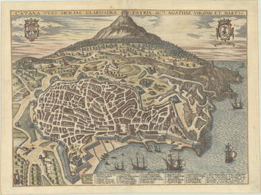
SoldIerusalem - Panoramic Map View of Jerusalem, ProbablyIerusalem - Panoramic Map View of Jerusalem, Probably 18th Century. Following the map of Jacques Chereau (1688-1776) from the 18th century. Copperplate. Colored. 21x34cm.See Sold Price
SoldPanoramic Map of Jerusalem. 18th Century?Ierusalem. Panoramic map of Jerusalem within the walls. Copperplate. Black and white. Following the map of J. Chereau from the 18th century. Page spread. German. 20.7x34 cm. Quality paper. ProfessionaSee Sold Price
SoldPanorama of Jerusalem - Holland, Late 17th CenturyIerusalem - Panoramic view of Jerusalem from the Mount of Olives, by the Dutch artist Cornelis de Bruyn, Delft, Holland, 1698. Etching spread on three sheets. 34X128 cm, good condition. Dark paper, frSee Sold Price
SoldPanoramic Map of Jerusalem - Sebastian Munster...Die heilige statt Jerusalem contrafehtet nach form uns gestalt wie sie ietz erbauwen ist [view of Jerusalem], Sebastian Munster. Basel, second half of 16th century. German. Panoramic map of JerusalemSee Sold Price
SoldHoly Land.- Villapandro (Juan Bautista), After.Holy Land.- Villapandro (Juan Bautista), After. Ierusalem [Bird's-eye plan of ancient Jerusalem], panoramic view with 52-point key identifying locations, engraving on two sheets of laid paper withoutSee Sold Price
SoldMallet: Antique Map, City View of Jerusalem, 1683Title: 'Ierusalem Moderne' Shows Muslims praying and many mosques. View of the city. Date Printed: 1683 Image Size: Approx Overall page size 13 x 21cm approximately (5 x 8 inches); image size 10.5 x 1See Sold Price
SoldMap of Jerusalem. Hartmann Schedel. Incunabula.Desruccio Iherosolime. Panoramic, imaginative map of Jerusalem in its destruction. Incunabula. View from east to west. The Temple burning. By Hartmann Schedel. From: "Liber Cronicarum" [known as "TheSee Sold Price
SoldPanorama of Jerusalem - Augsburg, 18th CenturyIerusalem Hodierna, drawn by Georg Balthasar Probst. [Augsburg, ca. 1750]. Panoramic map which consists of two sheets of paper, portraying Jerusalem at the beginning of the 18th century, with 80 waypoSee Sold Price
SoldMap of Jerusalem. Hartmann Schedel. Incunabula.Desruccio Iherosolime. Panoramic map of Jerusalem during its destruction. By Hartmann Schedel. Nurnberg 1493. Incunabula. Folded leaf. 40x56 cm. Latin. View from east to west. Depicts the Holy TempleSee Sold Price
Merian: Antique Panoramic View of Jerusalem, 1640sMap: Ierusalem Cartographer: Merian Place & Date: Frankfurt / 1640s Size: 13 1/8" x 8" Condition: b&w; overall age toning and some staining; centerfold reinforced and tear in lower margin restored MerSee Sold Price
Photographic Panorama of Jerusalem Antique Map - TheJerusalem – Panoramic view of Jerusalem from the Mount of Olives, s. 78 X 30 cm, good condition. Dark paper, framed. <See Sold Price
SoldLarge Panoramic View of Jerusalem, Olfert Dapper, 1677.Large Panoramic View of The City Jerusalem, Olfert Dapper, 1677. Copper engraving. 71cm X 29cm / 28in X 11.4in.See Sold Price
JERUSALEM. View of the city. Mosques. 'IerusalemTITLE OF THE PRINT: 'Ierusalem Moderne' Shows Muslims praying and many mosques DATE PRINTED: 1683 IMAGE SIZE: Approx Overall page size 13 x 21cm approximately (5 x 8 inches); image size 10.5 x 14.5cmSee Sold Price
JERUSALEM. View of the city. Mosques. 'IerusalemTITLE OF THE PRINT: 'Ierusalem Moderne' Shows Muslims praying and many mosques DATE PRINTED: 1683 IMAGE SIZE: Approx Overall page size 13 x 21cm approximately (5 x 8 inches); image size 10.5 x 14.5cmSee Sold Price
1588 Braun and Hogenberg View of Jerusalem (Partial) -- Ierusalem, et Suburbia Eius, Sicut TemporeTitle: 1588 Braun and Hogenberg View of Jerusalem (Partial) -- Ierusalem, et Suburbia Eius, Sicut Tempore Christi Floruit, cum Locis, in Quibus Christus Passus Cartographer: Braun and Hogenberg Year /See Sold Price
SoldJerusalem and the Temple Place -'Gruss aus'- Souvenir5 Souvenir 'Gruss aus' postcards - Jerusalem and Temple. Around 1900. A rare postcard depicting the Middle East map witch in the center Eretz Israel and a panoramic view of the city of Jerusalem. G. SSee Sold Price
MAP, Jerusalem, Holy Land, SavryJerusalem, Holy Land. Jacob Savry, De Heylige en Wytvermaerde Stadt Ierusalem, Eerst Genaemt Salem, 1648 (dated). Hand Color. This detailed bird's-eye view is based on Claes Janszoon Visscher's depictSee Sold Price
SoldMAP, Jerusalem, Holy Land, VisscherJerusalem, Holy Land. Nicolas Visscher, De Heylige en Wytvermaerde Stadt Ierusalem eerst Genaemt Salem Genesis 14. Vers 18, 1664 (published). Hand Color. This detailed bird's-eye view was one of the mSee Sold Price
SoldJerusalem Map from the days of King Solomon. ThomasIerusalem quails (vt plurimum) extitit aetate Solomonis. Imaginary map of Jerusalem during the era of King Solomon. Copperplate engraving. Black and white. View from south to north. Thomas Fuller, LonSee Sold Price
SoldMAP, Jerusalem, Holy Land, VisscherJerusalem, Holy Land. Nicolas Visscher, De Heylige en Wytvermaerde Stadt Ierusalem Eerst Genaemt Salem Genesis 14. Vers 18, 1665 (published). Hand Color. This detailed bird's-eye view was one of the mSee Sold Price
SoldPanoramic Map of Jerusalem - WhittockPanoramic Map of Jerusalem and the Adjacent Towns and Villages, taken from the Heights of Bethlehem by the Librarian of the Armenian Convent. Drawn from the original and engraved by Nathaniel WhittockSee Sold Price
SoldPanoramic View of Jerusalem - London, 1660Hierusalem Veteris Imago Vera. Panoramic view of Jerusalem, engraving by Wenceslaus Hollar. London, 1660. Panoramic plan composed of two sheets of paper, with 50 landmarks. On the upper left corner -See Sold Price
SoldMiddle East Panoramic View Of Jerusalem[Middle East]. Panoramic photographic view of Jerusalem by W. R. Wallace, London, elevated view showing a large portion of the Old City. 8 3/4 x 37 1/4. Matted and framed, sight condition very good. TSee Sold Price
SoldPanoramic View of JerusalemGerusalemme. Panoramic view of Jerusalem between the walls, oriented from east to west. Copperplate engraving. Black and white. In the upper right corner: "To. 6. pag. 342". 20*17* Quality paper. VerySee Sold Price
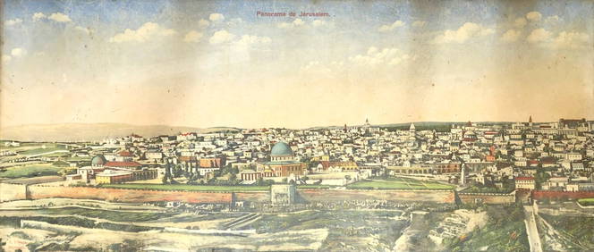
Panorama View of Jerusalem - L. Ferid - 19th CenturyLevy Auction House4.3(11)See Sold PriceFeb 27, 2024
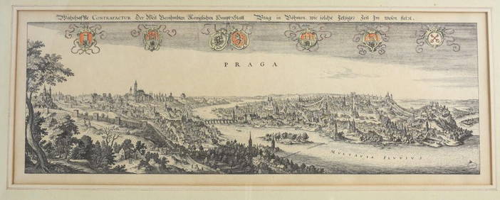
Matthaus Merian (Swiss 1593-1650) Engraving Panoramic View of PragueGlobal Auctions Company4.3(36)See Sold PriceMar 03, 2024
Antique German Kampen Town Color Copper EtchingHill Auction Gallery 4.7(1k)See Sold PriceFeb 28, 2024
GUNDLACH KORONA PANORAMIC VIEW BANQUET CAMERAAustin Auction Gallery4.7(1.2k)See Sold PriceApr 12, 2024