SoldCarol Allard, Antique 17th C. Map of CataloniaHand colored engraving. Framed. Approx. 20" H x 24" W w/o frame, 26" H x 30" W framed. From an estate on the Upper West Side. (4050) Wear and creasing.See Sold Price
SoldNicolas Sanson & Louis Cordier, Antique 17th C MapOf the Principaute de Catalogne. Hand colored engraving. Approx. 16" H x 19" W w/o frame, 21" H x 24" W framed. From an estate on the Upper West Side. (4050) Wear and creasing due to age.See Sold Price
SoldJ. Blaeu, Antique 17th C. Map of NavarraHand colored engraving. Framed. Approx. 17" H x 20" W w/o frame, 24" H x 27" W framed. From an estate on the Upper West Side. (4050) Some creasing due to age.See Sold Price
ANTIQUE 17TH C MAP CASTILIA W. BLAEUAntique map of Castilia by W. Blaeu. Title: Utriusquae Castiliae Nova Descriptio. By: Willem Jansz. (also written Guilielmus Janssonius) -- Willem Janszoon Blaeu. Date of the first edition/map first pSee Sold Price
Sold17th c HAND COLORED MAP OF RUGENAntique 17th c. Map Rugia Insula ac Ducatus. Highly decorative map of the island of Rugen. Embellished with a title-cartouches, and 30 coats-of-arms in the borders. From the French edition of Willem BSee Sold Price
SoldANTIQUE 17th/18th c MAP ST PAULAntique 17th/18th c. Map showing the travels of The Apostles and St. Paul in the Mediterranean. Professionally framed and matted, measures 23"x26"x1". Weight 7 pds. PROVENANCE: A Private Charleston SCSee Sold Price
SoldAntique 17th C. Norfolk England Map EngravingAntique 17th C. Norfolk, England Map Hand Colored Engraving. Described by Christopher Saxton. Augmented by I. Speede. Measures 16 inches high x 21.5 inches wide.See Sold Price
SoldAntique 17th C Blaeu Tabula Magellanica MapAntique 17th Century Willem Blaeu (Dutch, 1571-1638) Hand Colored Tabula Magellanica Map. Map measures 16 inches high x 21 inches wide. Frame measures 17 inches high x 22.5 inches wide.See Sold Price
Sold17th c. Antique H/C Map of Ottoman / Turkish EmpireMap - Accuratissima et maxima totius Turcici Imperii tabula cum omnibus suis regionibus novissima delineatio | Title: Accuratissima et maxima totius Turcici Imperii tabula cum omnibus suis regionibusSee Sold Price
SoldAntique 1930s Folding 6' Screen 17thC Map o MadridAntique 1930s Dividing 6' Screen 17th Century Map of Madrid Fine 1930s room dividing screen was purchased from world-renowned luxury goods department store Bergdorf Goodman in New York City. Art DecoSee Sold Price
SoldFrance Antique Map & View, 17th C.Descriptio Veromanduorum, Antique map, Blaeu, Amsterdam, mid 17th C. W/ view Mommedy on 2 separate sheets, engraving by Israel Silvestre, 1669. 19 1/2" x 26 1/4".See Sold Price
SoldFour Antique Continental MapsFour Antique Continental Maps , 17th to 19th c., incl. map of Ireland, British Colonies, Virginia, and two bird's-eye-views, largest 18 3/4 in. x 26 in Provenance: Property deaccessioned from the LouiSee Sold Price
SoldMap, Marchionatus Misniae una cum VoitlandiaAn antique map. 17th century, c.1630. Titled Marchionatus Misniae una cum Voitlandia by Dutch Cartographer, atlas maker and publisher Henricus Hondius. A copperplate engraving in full color. The sheetSee Sold Price
SoldMap, Principatus Anhaldinus et MagdeburgensisAn antique map. 17th century, c.1630, Titled Principatus Anhaldinus et Magdeburgensis, Archiepiccopatus, by Dutch Cartographer, atlas maker and publisher Jodocus Hondius (1563-1612). A copperplate engSee Sold Price
Sold17th C. Map of New Netherlands - Nicholas Visscher"Novi Belgii Novaeque Angliae Nec Non partis Virginiae Tabula"--1656, hand colored engraved map, second state. Antique map depicting early view of America (or New Netherlands) with one of the first deSee Sold Price
17th C. Map of ItalyCapitanata, Olim Mesapiae Et Iapygiae Pars; from Blaeu's Theatrum, 1650. Hand colored with decorative cartouche. Framed, 26" x 22.5". From Godspeed's Book Shop, Boston.See Sold Price
Sold17th C. Map of ItalyCapitanata, Olim Mesapiae Et Iapygiae Pars; from Blaeu's Theatrum, 1650. Hand colored with decorative cartouche. Framed, 26" x 22.5". From Godspeed's Book Shop, Boston.See Sold Price
(3) ANTIQUE MAPS, GERMANY, 17TH & 18TH C.(lot of 3) Antique maps, including: (1) "Dithmarshen" (Northern Germany), with inset maps of "Brunsbuttel, 1644" and "Meldorpia, 1500," Johannes Mejer (German, c.1606-1674), hand colored, including seSee Sold Price
SoldEight Antique Maps by BlaeuEight Antique Maps by Blaeu , 17th c., hand-colored engravings, incl. Holland, Frankfort, Austria, Umbria, and others, sheets 19 1/2 in. x 23 in Provenance: Property deaccessioned from the Louisiana SSee Sold Price
SoldNine Antique Maps of EuropeNine Antique Maps of Europe , 17th c., by Mercator and Jansson, hand-colored engravings, sheets 19 1/2 in. x 23 in Provenance: Property deaccessioned from the Louisiana State Museum, proceeds to be usSee Sold Price
SoldEight Antique Maps by HoefnagelEight Antique Maps by Hoefnagel , 17th c., from Civitates Orbis Terrarum, 5 hand-colored, sheets 16 in. x 20 in Provenance: Property deaccessioned from the Louisiana State Museum, proceeds to be usedSee Sold Price
SoldANTIQUE SPANISH MAP, JOHANNES BLAEU, 17TH C."Episcopatus Tervelensis et Albaracinensis" a regional map of Spain, 17th c., Johannes Blaeu (Dutch, 1596-1673), hand colored figural cartouche at lower left, center fold mark, tears at edges, sight wSee Sold Price
Sold17th c. Amsterdam Map[Antique Map] Nicholda Visscher, "Hollandiae Comitatus...", Amsterdam, C. 1690. Hand-colored. 38" h x 31 1/4" w = frameSee Sold Price
SoldEARLY MAP "INSULA CANDIA EJUSQUE FORTIFICATIO",FREDRICK DE WIT, 18" X 21 1/2", POSSIBLY 17TH C. THIS MAP OF THE ISLAND OF CRETE SHOWING THE ISLAND FOLLOWING THE SIEGE OF CANDIA, 24 YEAR CONFLICT IN WHICH THE OTTOMANS BESIEGED THIS VENETIAN RULED CSee Sold Price
LARGE LATE 17TH C. DUTCH CHART OF CANADA, GREAT LAKES, NEW FRANCE, LABRADOR, HUDSON BAY, BY PIERREThomaston Place Auction Galleries4.4(386)See Sold PriceFeb 24, 2024
17TH C. WORLD MAP BY NICOLAES VISSCHER (NETHERLANDS, 1618-1709)Thomaston Place Auction Galleries4.4(386)See Sold PriceFeb 24, 2024
LATE 17TH C. FRENCH MAP OF THE NEW WORLD BY ALEXIS-HUBERT JAILLOT (1632-1712)Thomaston Place Auction Galleries4.4(386)See Sold PriceFeb 24, 2024
17TH C. ANTIQUE MAP SIEGE OF LA ROCHELLE, FRANCE, FRAMEDThomaston Place Auction Galleries4.4(386)See Sold PriceFeb 24, 2024
17TH C. MAP OF THE BERKSHIRES BY JOHN SPEED, FRAMEDThomaston Place Auction Galleries4.4(386)See Sold PriceFeb 24, 2024
18TH C. ANTIQUE MAP: FRENCH & INDIAN WAR, FRAMEDThomaston Place Auction Galleries4.4(386)See Sold PriceFeb 24, 2024
17TH C. ENGLISH LINEAR MAP BY OGILBY, FRAMEDThomaston Place Auction Galleries4.4(386)See Sold PriceFeb 24, 2024
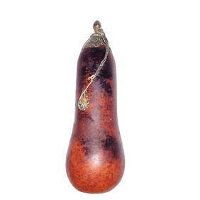
ANTIQUE CHINESE NATURAL GOURD SNUFF BOTTLE SILVERNoble House Collection Gallery4.5(114)See Sold PriceMar 10, 2024
Antique 17th C English Geometric Oak Chest of DrawersKavanagh Auctions4.7(292)See Sold PriceFeb 24, 2024
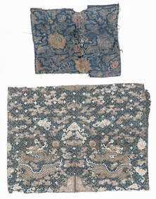
2 Antique Chinese Textile Fragments, 17th C. and 19th C.Material Culture4.6(765)See Sold PriceFeb 29, 2024
Willem Blaeu, Etc. 17th C. Antiquarian Maps, 2Auctions at Showplace4.5(726)See Sold PriceMar 17, 2024
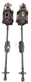
PAIR OF 17th C. STYLE VENETIAN WALL MOUNT LANTERNSLewis & Maese Antiques & Auction4.4(520)See Sold PriceFeb 25, 2024
Two (2) Antique 18th C. Copper Engraved Framed Maps - America & EuropeMagnusson Art Group4.5(46)See Sold PriceMar 14, 2024
Map: A 17thC engraved and hand coloured map of Scotland titled Strath-Navernia / Strath Navern afterClaydon Auctioneers Ltd4.3(125)See Sold PriceFeb 26, 2024
Map: A 17thC engraved map of the British Isles titled A Generall Mapp of the Isles of GreatClaydon Auctioneers Ltd4.3(125)See Sold PriceFeb 26, 2024
Map: A 17thC engraved and hand coloured map of Bedfordshire after Robert Morden. Approx. 12 1/2" xClaydon Auctioneers Ltd4.3(125)See Sold PriceFeb 26, 2024
Map: A 17thC engraved and hand coloured map after Frederik de Wit (1630-1706) titled Nova Persiae,Claydon Auctioneers Ltd4.3(125)See Sold PriceFeb 26, 2024
17th C. 14K Yellow Gold, Pearl and Enamel Hoop EarringsGWS Auctions Inc.4.4(265)See Sold PriceMar 02, 2024
1675: ANTIQUE ILLUSTRATED JULIUS CAESAR MAPS OF ROMAN HISTORYNY Elizabeth 4.3(84)See Sold PriceMar 03, 2024