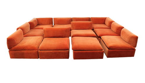
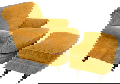
11pc. MCM Vintage Modular Sofa Set, removable backs, make up your own setting, desirable orangeSouth Jersey Auction by Babington Auction Inc4.6(122)See Sold PriceFeb 25, 2024
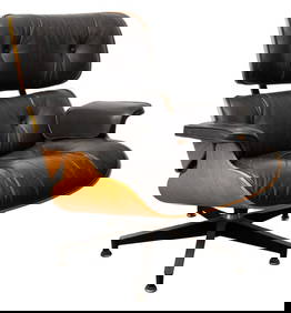
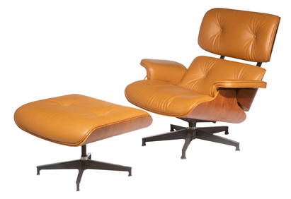
Charles & Ray Eames for Herman Miller Lounge ChairAuctions at Showplace4.5(726)See Sold PriceMar 03, 2024
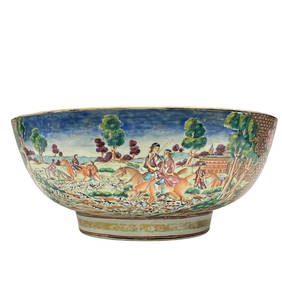
Important Qianlong Chinese Export Hunt Scene BowlPremier Auction Galleries4.3(329)See Sold PriceMar 09, 2024
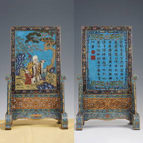
A FINE CHINESE CLOISONNE ENAMEL LONGEVITY TABLE SCREENBerkeley Auction Gallery4.4(16)See Sold PriceMar 03, 2024
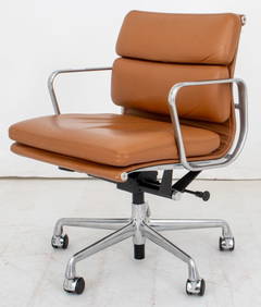
Eames for Herman Miller Executive Soft Pad ChairAuctions at Showplace4.5(726)See Sold PriceMar 03, 2024
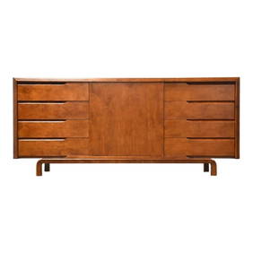
Danish Mid-Century Modern Model CH 25 Lounge Chair in Oak and Leather by Hans J. Wegner for CarlBidhaus4.3(747)See Sold PriceFeb 26, 2024
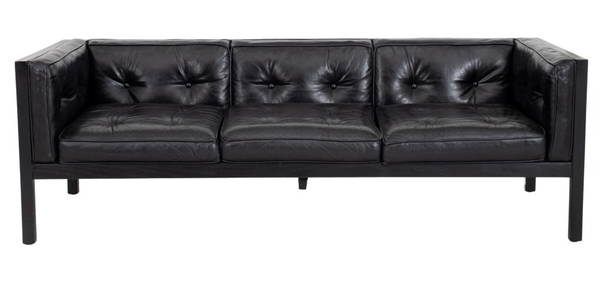
George Nelson Herman Miller Leather "Cube" SofaAuctions at Showplace4.5(726)See Sold PriceMar 03, 2024
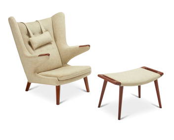
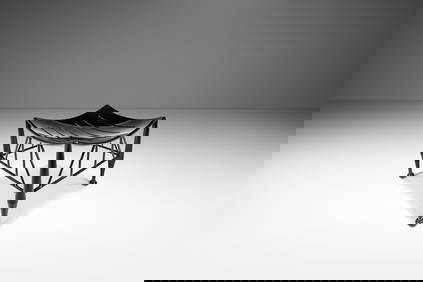
Hans Wegner (1914-2007), AP-19 Papa Bear chair and ottoman for A.P. Stolen, 1953-1969; DenmarkJohn Moran Auctioneers, Inc.4.7(453)See Sold PriceFeb 27, 2024
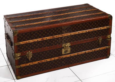
A FINE LARGE LOUIS VUITTON TRAVELING WARDROBE C. 1920sSoulis Auctions4.8(953)See Sold PriceFeb 24, 2024
Period 18Th C. Queen Anne Bonnet Top Tiger Maple HighboyRalph Fontaine Heritage Auctions Inc.4.7(235)See Sold PriceFeb 25, 2024
Rare Mid-Century Modern Egyptian Revival Ebonized "Thebes" Stool by Liberty & Company UnitedBidhaus4.3(747)See Sold PriceFeb 26, 2024
Lewis Mittman Upholstered Club Chair and OttomanNadeau's Auction Gallery4.7(401)See Sold PriceFeb 24, 2024
Single Bentwood Prague Model 811 Dining Chair by Josef Frank Josef Hoffmann for Stendig withBidhaus4.3(747)See Sold PriceFeb 24, 2024
SoldAntique 17th C. Norfolk England Map EngravingAntique 17th C. Norfolk, England Map Hand Colored Engraving. Described by Christopher Saxton. Augmented by I. Speede. Measures 16 inches high x 21.5 inches wide.See Sold Price
SoldNicolas Sanson & Louis Cordier, Antique 17th C MapOf the Principaute de Catalogne. Hand colored engraving. Approx. 16" H x 19" W w/o frame, 21" H x 24" W framed. From an estate on the Upper West Side. (4050) Wear and creasing due to age.See Sold Price
SoldJ. Blaeu, Antique 17th C. Map of NavarraHand colored engraving. Framed. Approx. 17" H x 20" W w/o frame, 24" H x 27" W framed. From an estate on the Upper West Side. (4050) Some creasing due to age.See Sold Price
SoldCarol Allard, Antique 17th C. Map of CataloniaHand colored engraving. Framed. Approx. 20" H x 24" W w/o frame, 26" H x 30" W framed. From an estate on the Upper West Side. (4050) Wear and creasing.See Sold Price
Sold17th c. Antique H/C Map of Ottoman / Turkish EmpireMap - Accuratissima et maxima totius Turcici Imperii tabula cum omnibus suis regionibus novissima delineatio | Title: Accuratissima et maxima totius Turcici Imperii tabula cum omnibus suis regionibusSee Sold Price
THREE ANTIQUE 18TH C FRAMED MAPS: SPAIN, ENGLANDLot of three antique 18th century hand colored map engravings. Includes Balearic Islands, Spain, 1778, Antonio Zatta; Buckinghamshire, 1787, J. Cary; and Oxfordshire, 1787, J. Cary. The two smaller EnSee Sold Price
SoldFrance Antique Map & View, 17th C.Descriptio Veromanduorum, Antique map, Blaeu, Amsterdam, mid 17th C. W/ view Mommedy on 2 separate sheets, engraving by Israel Silvestre, 1669. 19 1/2" x 26 1/4".See Sold Price
SoldFramed large antique map of China, Japan and KoreFramed large antique map of China, Japan and Korea. Hand-colored copper-plate engraving. Dutch map. Circa 17th C, possibly earlier by Jodocus Hondius, from Hondius' Gerardi Mercatoris Atlas, publishedSee Sold Price
SoldMap, Marchionatus Misniae una cum VoitlandiaAn antique map. 17th century, c.1630. Titled Marchionatus Misniae una cum Voitlandia by Dutch Cartographer, atlas maker and publisher Henricus Hondius. A copperplate engraving in full color. The sheetSee Sold Price
Sold17TH C, MAP OF NEW ENGLAND, WILLEM BLAEU. FRAMEDWillem Blaeu (Dutch, 1751-1638). "Nova Belgica et Anglia Nova (Map of New Belgium and New England)" -1638, hand colored engraving. Elaborately framed. Approx. 28.5" X 33" (frame), 15.5" x 20" (sight)See Sold Price
SoldEight Antique Maps by BlaeuEight Antique Maps by Blaeu , 17th c., hand-colored engravings, incl. Holland, Frankfort, Austria, Umbria, and others, sheets 19 1/2 in. x 23 in Provenance: Property deaccessioned from the Louisiana SSee Sold Price
SoldNine Antique Maps of EuropeNine Antique Maps of Europe , 17th c., by Mercator and Jansson, hand-colored engravings, sheets 19 1/2 in. x 23 in Provenance: Property deaccessioned from the Louisiana State Museum, proceeds to be usSee Sold Price
Sold17th C. English School Map of Insulae Marianae 1617th C. English School engraving, Map of Insulae Marianae 1684 (Philippines) another map of Borneo Insulae and a print of the Labyrinthe.See Sold Price
Late 16th / Early 17thc Map of South East EnglandGerard Mercator ( 1565 - 1656 ) - Engraving - "South East England". With Latin text to the reverse, in modern Hogarth frame with glass to both sides.14 1/2" X 18 1/2". Provenance : R. Deverall, DuvalSee Sold Price
SoldMap, Ducatus Silesiae Wolanus, Iona ScultetoAn antique map of Poland. 17th century. c.1660. Titled Ducatus Silesiae Wolanus, Author, Jona Sculteto, Sprotta Silesio. A copperplate engraving in full color. The sheet measures 20.5" x 24". AppearsSee Sold Price
Sold17th and 18th C. Maps of Florida and EnglandTwo 17th & 18th century maps. Item 1: Hand-colored and engraved map of West Florida, dated 1772. Titled "A Map of Part of West Florida, from Pensacola to the Mouth of the Iberville River, with a ViewSee Sold Price
SoldROBERT MORDEN MAP OF NORFOLK COUNTY ENGLANDLate 17th century map of Norfolk which was produced by Robert Morden (engraved by John Sturt) for Camden's Britannia (London: Swale, Awnshaw & Churchill, 1695 - 1772). Copperplate engraving, hand coloSee Sold Price
AN ANTIQUE MAP OF SOUTHEAST ENGLAND, "Regni Angliæ,"AN ANTIQUE MAP OF SOUTHEAST ENGLAND, "Regni Angliæ," 17TH/18TH CENTURY, hand colored copper plate engraving on paper, a page fragment from a larger atlas, hand numbered 86 L/R, with theatrical curtaiSee Sold Price
SoldAN ANTIQUE MAP OF SOUTHEAST ENGLAND, "Regni Angliæ,"AN ANTIQUE MAP OF SOUTHEAST ENGLAND, "Regni Angliæ," 17TH/18TH CENTURY, hand colored copper plate engraving on paper, a page fragment from a larger atlas, hand numbered 86 L/R, with theatrical curtaiSee Sold Price
SoldAntique large A New Map of XVII Provinces of LowAntique large A New Map of XVII Provinces of Low Germanic. By J. Speed. Copper plate engraving. Circa 17th C. Measures 17" tall x 21" wide. Was originally purchased at Jonathan Potter., LTD, London. BSee Sold Price
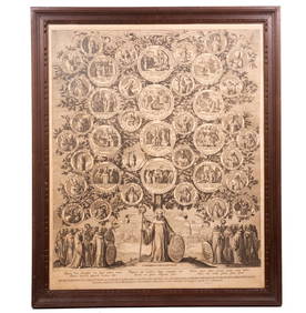
SoldAntique Tinted Map Northfolke England by C. Saxton,Antique hand tinted map of Northfolke England features the family shields with en verso listing of such; upper middle reads "NORFOLK A countie florishing & populous described and divided. Arms of suchSee Sold Price
SoldSaxton Engraving of Norfolk, EnglandSAXTON, Christopher (c. 1540 - c. 1610). Norfolciae comitatus continens in se Oppida Mercatoria. Engraved map with original hand color. London: 1579. 16 3/8" x 21 7/8" sheet. The first engraved countySee Sold Price
SoldFour 17th-18th C. Maps: Desing, Manesson-MallettCollection of four 17th and 18th European maps, Item 1: P. A. Desings map of the western hemisphere. Hand colored copper engraving published in 1741. 6 3/8" H x 5 3/4" W. Items 2 and 3: Two Manesson-See Sold Price
I. Slater's New Map of England & Wales, 1847A rare original antique map titled "I. SLATER'S NEW MAP OF ENGLAND & WALES with part of Scotland including the New Lines of Canals, Rail Roads, &c" by James Pigot and published by I. Slater, ManchesteSee Sold Price
LARGE LATE 17TH C. DUTCH CHART OF CANADA, GREAT LAKES, NEW FRANCE, LABRADOR, HUDSON BAY, BY PIERREThomaston Place Auction Galleries4.4(386)See Sold PriceFeb 24, 2024
17TH C. WORLD MAP BY NICOLAES VISSCHER (NETHERLANDS, 1618-1709)Thomaston Place Auction Galleries4.4(386)See Sold PriceFeb 24, 2024
LATE 17TH C. FRENCH MAP OF THE NEW WORLD BY ALEXIS-HUBERT JAILLOT (1632-1712)Thomaston Place Auction Galleries4.4(386)See Sold PriceFeb 24, 2024
17TH C. ANTIQUE MAP SIEGE OF LA ROCHELLE, FRANCE, FRAMEDThomaston Place Auction Galleries4.4(386)See Sold PriceFeb 24, 2024
17TH C. MAP OF THE BERKSHIRES BY JOHN SPEED, FRAMEDThomaston Place Auction Galleries4.4(386)See Sold PriceFeb 24, 2024
18TH C. ANTIQUE MAP: FRENCH & INDIAN WAR, FRAMEDThomaston Place Auction Galleries4.4(386)See Sold PriceFeb 24, 2024
17TH C. ENGLISH LINEAR MAP BY OGILBY, FRAMEDThomaston Place Auction Galleries4.4(386)See Sold PriceFeb 24, 2024
LUCAS VORSTERMAN THE ELDER (FLEMISH, 1595-1675)Thomaston Place Auction Galleries4.4(386)See Sold PriceFeb 24, 2024
Johann Homann Hand-Colored Map Engraving, c. 1730Auctions at Showplace4.5(726)See Sold PriceMar 17, 2024
Willem Blaeu, Etc. 17th C. Antiquarian Maps, 2Auctions at Showplace4.5(726)See Sold PriceMar 17, 2024
Map: A 17thC engraved and hand coloured map of Scotland titled Strath-Navernia / Strath Navern afterClaydon Auctioneers Ltd4.3(125)See Sold PriceFeb 26, 2024
Map: A 17thC engraved map of the British Isles titled A Generall Mapp of the Isles of GreatClaydon Auctioneers Ltd4.3(125)See Sold PriceFeb 26, 2024
Map: A 17thC engraved and hand coloured map of Bedfordshire after Robert Morden. Approx. 12 1/2" xClaydon Auctioneers Ltd4.3(125)See Sold PriceFeb 26, 2024
Map: A 17thC engraved and hand coloured map after Frederik de Wit (1630-1706) titled Nova Persiae,Claydon Auctioneers Ltd4.3(125)See Sold PriceFeb 26, 2024