SoldTwo 18th C. Hand Colored Engraved Maps.From a Connecticut, CT estate. Dimensions: sheets - 17" high x 24.5" wide and 16.5" high x 25" wide. Condition: Not examined out of frames. Toned paper, trimmed margins, both with center fold creases,See Sold Price
SoldHERMAN MOLL HAND COLORED ENGRAVED MAPS 18TH C. TWOHERMAN MOLL, HAND COLORED ENGRAVED MAPS, 18TH C., TWO, GREAT BRITAIN, IRELAND, GALLOWAY:Under glass and matted in matched frames. Lyons Ltd., Antique Prints label. Visible image size 7 3/4" x 10 1/4".See Sold Price
Sold17th and 18th C. Maps of Florida and EnglandTwo 17th & 18th century maps. Item 1: Hand-colored and engraved map of West Florida, dated 1772. Titled "A Map of Part of West Florida, from Pensacola to the Mouth of the Iberville River, with a ViewSee Sold Price
Sold18TH C. HANDCOLORED ENGRAVED MAP OF AMSTERDAMDimensions: (Frame) H 15.75" x W 16", (Sight) H 9.75" x W 10.25" Condition: Some age toning and spotting.See Sold Price
Sold18th C. Map of LouisianaAn 18th C. hand-colored engraved map by Emanuel Bowen, titled "A New and Accurate Map of Louisiana with Part of Florida and Canada, and the Adjacent Countries", Plate 59. Likely from the "Complete AtlSee Sold Price
Sold18th C. Hand-Colored Map of New EnglandAn 18th C. hand-colored engraved map of New England, Nova Scotia, New France, or Canada, with the Islands of Newfoundland, Cape Breton, St. John's, by Jacques-Nicholas Bellin. Framed under glass. MatSee Sold Price
Sold*ZATTA, ANTONIO(18th C. Italian) Handcolored engraved map illustrating Maryland, Jersey, Delaware, Virginia and Carolina settlements, approximate plate size 13 1/4" x 17 1/2", frame 16" x 22 1/2".See Sold Price
SoldAntique French Map of St. AugustineAntique French Map of St. Augustine, "Plan de la Ville et Port de St. Augustin", late 18th/early 19th c., hand-colored engraved map, sight 8 1/2 in. x 12 in., framed. Provenance: Estate of Faith K. TiSee Sold Price
Sold(2) 18th C Double-page, hand-colored maps(2) 18th C Double-page, hand-colored etched and engraved maps taken from an atlas, inc the Champagne region of France and Antwerp, largest 16-1/2" x 20-1/2" pl, very good conditionSee Sold Price
SoldJan Jansson (Dutch, 1588-1664)Jan Jansson (Dutch, 1588-1664), "Somersettensis Comitatus Somerset Shire" and "Suthsexia vernacule Sussex", c. 1650, two hand-colored engraved copperplate maps, from the Atlas Noveus, with beautiful cSee Sold Price
SoldNicholas Sanson D'Abbeville engraved mapNicholas Sanson D'Abbeville- ''Le Royaume De France divite en Toute fes Provinces et fes Acquifition''- hand-colored engraved map, Paris, 18th c. 19 1/4 x 23''See Sold Price
SoldMatthaus Seutter hand colored engraved mapMatthaus Seutter hand colored engraved map, early 18th c., inscribed Europa Religionis Christianae Morum et Pacis ac Belli Artium Cultu Omnium Terrarum Orbis Partium Praestantiss...., 20'' x 23''. ProSee Sold Price
Sold18th c. Florida Map - Herman MollFLORIDA, CALLED BY YE FRENCH LOUISIANA & C., hand colored engraved map by Herman Moll (1688-1732), originally appeared in Moll's Atlas Minor (1736). 8 1/8" x 11" plate, 8 3/8" x 11 1/8" sight, 15" x 1See Sold Price
Original 18th c. H/C Engraved Lattré Map of EuropeAntique Original Hand-colored Engraved Map of Europe from PETIT ATLAS MODERNE ou collection de cartes élémentaires dédié à la jeunesse | Engraved and published in Paris by Jean Lattr�See Sold Price
6 18th/19th C. Hand Colored Engraved MapsLot of six 18th/19th century hand colored engraved maps of Milanese states, Northern Asia, England and Wales, Turkey, Canada and Nova Belgica et Anglica, largest measures 21 1/4" h x 27" w. ProvenanceSee Sold Price
Sold[ 18th c. Wall Map of Africa][Fine 18th c. Wall Map of Africa], "Africa with All Its States, Kingdoms, Republics, Regions, Islands...", 1794, London, published by Laurie & Whittle, hand-colored engraved map, dissected and mountedSee Sold Price
SoldEngraved map, Delahaye, Paris, 18th c.Framed hand-colored engraved map, Carte du Departement de la Seine et de l'Oise, 1791, by Louis Delahaye (French, 18th century), plate: 19.5''h x 19.5''w, overall: 33.5''h x 32''wSee Sold Price
Sold18thc Map of Asia, John Senex, EnglandFramed English hand-colored engraved map by John Senex "A New Map of Asia" TITLE: A New Map of Asia from the latest Observations Most Humbly Inscrib'd to the Right Honbl. George Earl of Warrington & cSee Sold Price
SoldPomerania Central Europe Antique MapDucatus Pomeraniae. Hand-colored engraved map. J.B. Homann, Nuremberg, 18th C.. 21" x 24".See Sold Price
SoldBurgandy France Antique MapComitatus Burgundiae. Hand-colored engraved map. French wine region. J.B. Homann, Nuremberg, 18th C. 24 3/4" x 21".See Sold Price
Sold18th C. Milan Ducatus Mediterranean Map18th C. framed copper engraved map, hand colored of Milan, Genoa, Lake Como and Mantua Cartouche. By Matthai Serteri, S.C.M. GEOGR Augustani. Visible paper measures approximately 20.25" H X 24" W, witSee Sold Price
Sold18th c. H/C Map Flamsteed and Fortin 177618th Century hand-colored engraved Celestial Map / Zodiac Map Entitled Le Lynx, Le Petit Lion (Lynx, Small Lion), plate 5, from "Atlas Céleste de Flamstéed, approuvé par l'Académie Royale des ScieSee Sold Price
SoldA Group Of 17-18 & 19th C Maps Hand Colored EngravedA Group Of 17-18 & 19th C Maps Hand Colored Engraved. These Are Affixed To A Screen Or Divider. 17 & 18th C Maps Are Hand-colored And Etched or Engraved. The 19th C Maps Are Rand McNally. Please ViewSee Sold Price
SoldEman'l Bowman 18th c map of Yorkshire18th c engraved and hand colored map by Emmanuel Bowman London " West Riding of Yorkshire divided into its Wapontakes" 22 x 29"See Sold Price
LATE 18TH C. VERY LARGE CHART OF NORTHEAST CANADA BY DES BARRES (1721-1824), 1780, FRAMEDThomaston Place Auction Galleries4.4(393)See Sold PriceFeb 24, 2024
LARGE LATE 17TH C. DUTCH CHART OF CANADA, GREAT LAKES, NEW FRANCE, LABRADOR, HUDSON BAY, BY PIERREThomaston Place Auction Galleries4.4(393)See Sold PriceFeb 24, 2024
17TH C. WORLD MAP BY NICOLAES VISSCHER (NETHERLANDS, 1618-1709)Thomaston Place Auction Galleries4.4(393)See Sold PriceFeb 24, 2024
LATE 17TH C. FRENCH MAP OF THE NEW WORLD BY ALEXIS-HUBERT JAILLOT (1632-1712)Thomaston Place Auction Galleries4.4(393)See Sold PriceFeb 24, 2024
EARLY 18TH C. DUTCH CHART OF PACIFIC OCEAN BY FREDERIK DE WIT (1629-1706) WITH CALIFORNIA AS ANThomaston Place Auction Galleries4.4(393)See Sold PriceFeb 24, 2024
EARLY 18TH C. MAP OF ITALY, FRAMEDThomaston Place Auction Galleries4.4(393)See Sold PriceFeb 24, 2024
18TH C. ANTIQUE MAP: FRENCH & INDIAN WAR, FRAMEDThomaston Place Auction Galleries4.4(393)See Sold PriceFeb 24, 2024
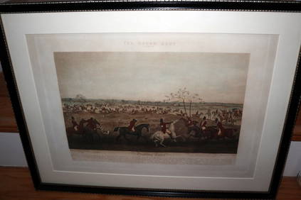
HENRY ALKEN / LEWIS Original 1835 Hand Colored Engraving Quorn Hunt DrawingLuis Porretta Fine Arts4.3(10)See Sold PriceMar 02, 2024
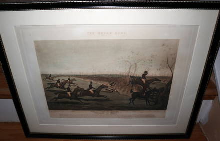
HENRY ALKEN / LEWIS Original 1835 Hand Colored Engraving Quron Hunt Snob Is BeatLuis Porretta Fine Arts4.3(10)See Sold PriceMar 02, 2024
18th Century Hess Germany Hand colored Engraved MapGlobal Auctions Company4.3(36)See Sold PriceMar 03, 2024
Willem Blaeu, Etc. 17th C. Antiquarian Maps, 2Auctions at Showplace4.6(740)See Sold PriceMar 17, 2024
Two (2) Antique 18th C. Copper Engraved Framed Maps - America & EuropeMagnusson Art Group4.5(53)See Sold PriceMar 14, 2024
Map: An 18thC engraved and hand coloured map of Buckinghamshire after Robert Morden. Approx. 8 1/4"Claydon Auctioneers Ltd4.3(125)See Sold PriceFeb 26, 2024
Map: An 18thC engraved and hand coloured map of Northamptonshire, with description ofClaydon Auctioneers Ltd4.3(125)See Sold PriceFeb 26, 2024
Map: An 18thC engraved and hand coloured map of North America and South America, titled DeClaydon Auctioneers Ltd4.3(125)See Sold PriceFeb 26, 2024


![[ 18th c. Wall Map of Africa] (1 of 10)](https://p1.liveauctioneers.com/268/50497/23771487_1_x.jpg?height=282&quality=70&version=1390496354)