ATLAS of ANTIENT GEOGRAPHY by SAMUEL BUTLER 1843John McInnis Auctioneers,LLC4.5(505)See Sold PriceFeb 24, 2024
18TH C. ANTIQUE MAP: FRENCH & INDIAN WAR, FRAMEDThomaston Place Auction Galleries4.4(393)See Sold PriceFeb 24, 2024
Rand McNally Railroad Map Cabinet w/ 21 Railroad MapsRail & Road Auctions4.6(165)See Sold PriceMar 08, 2024
Keith Haring - Ink on New York Map, Best Buddies, Inscribed, Signed, and DatedSapphire Auction Gallery4.1(67)See Sold PriceMar 02, 2024
LATE 17TH C. FRENCH MAP OF THE NEW WORLD BY ALEXIS-HUBERT JAILLOT (1632-1712)Thomaston Place Auction Galleries4.4(393)See Sold PriceFeb 24, 2024
Central Railroad of New Jersey Map of Sandy Hook Route-ca. 1903JM Hobby Supply and Railroad Artifact Auctions4.4(127)See Sold PriceFeb 24, 2024
Lot of Six Mixed Atlas Box Cars-HO Scale-New in BoxJM Hobby Supply and Railroad Artifact Auctions4.4(127)See Sold PriceFeb 25, 2024
Rand McNally/Santa Fe Railroad Map of Iowa-1912JM Hobby Supply and Railroad Artifact Auctions4.4(127)See Sold PriceFeb 24, 2024
NICOLAES VISSCHER (NETHERLANDS, 1618-1709) MAP OF THE NEW WORLDThomaston Place Auction Galleries4.4(393)See Sold PriceFeb 24, 2024
17TH C. WORLD MAP BY NICOLAES VISSCHER (NETHERLANDS, 1618-1709)Thomaston Place Auction Galleries4.4(393)See Sold PriceFeb 24, 2024
Lot of Six Mixed Atlas Cabooses-HO Scale-New in BoxJM Hobby Supply and Railroad Artifact Auctions4.4(127)See Sold PriceFeb 25, 2024
SoldEman'l Bowman 18th c map of Yorkshire18th c engraved and hand colored map by Emmanuel Bowman London " West Riding of Yorkshire divided into its Wapontakes" 22 x 29"See Sold Price
Sold18th c. map of Africa showing known kingdomsHeading: Author: Robert de Vaugondy, Gilles and Didier Title: L'Afrique dressée, sur les relations les plus recentes, et assujettie aux observations astronomiques Place Published: [Paris] Publisher:See Sold Price
SoldEARLY 18th C. MAP, WESTERN HEMISPHERE, DE FERTitle: Map: L'Amerique Meridionale et Septentrionale, Pub: Nicholas de Fer, Date: (1700) Circa 1705, Medium: HC Engraving, Paper size: 11 3/4 x 17, Inscribed: Publisher identified in the matrix, CondiSee Sold Price
LARGE 18TH C MAP OF RUSSIAA FINE 18TH CENTURY MAP OF RUSSIA, 1750, ROBERT DE VAUGONDY. Partie Occidentale DE L'EMPIRE DE RUSSIE A finely engraved map with large title cartouche upper left dated 1750, original hand-colorinSee Sold Price
'Carte de l'Egypte Ancienne et Moderne' 18th C MapCarte de l'Egypte Ancienne et Moderne' Map. Large antique 18th C. atlas map, printed on thick, good quality paper with original outline hand colour/color and decorative title cartouche. Artist/CartogrSee Sold Price
Sold2nd Late 18th C. Map of "Amerique."Attributed via 2005 auction catalogue to Jean Janvier with the title "L'Amerique divisée par Grands Etats." and dated 1783? Differs from 1st example in having additional hand-coloring, possibly moreSee Sold Price
SoldLate 18th C. Map of "Amerique."Details from a 2005 Auction Catalogue. Published by Jean Janvier with the title "L'Amerique divisée par Grands Etats" in Paris approx. date: 1783-179? Dimensions: 12.25" x 17.75." Condition: Good.See Sold Price
SoldGuillaume de L'isle 18th C. Map of Asia, NorthernAuthor: Guillaume de L'isle. Hand Colored Published in 1760 in de I'Isle/Pierre Mortier, Amsterdam "Carte de Tartarie Dressee sur les Relations deSee Sold Price
Sold*FRAMED ANTIQUARIAN 18TH C. MAP"L'ecosse", Great Britain, Ireland and adjacent islands, published by Chez Basset of Paris, 1779, approximate plate size 22" x 19", frame 27" x 22".See Sold Price
'Carte de l'Egypte Ancienne et Moderne' 18th C Map'Carte de l'Egypte Ancienne et Moderne' Map. Large antique 18th century atlas map, printed on thick, good quality paper with original outline hand colour/color and decorative title cartouche. Artist/CSee Sold Price
18th C. Map Italy: Etats du Roy de SardaigneHand colored copper engraving atlas map on laid paper, 1787, by Clouet, J. B. L. (Jean-Baptiste Louis,) entitled "Etats du Roy de Sardaigne. (with) Isle de Sardaigne". A beautiful map, with inset, shoSee Sold Price
Sold18th C. Map of Italy18th C. map of Italy. Carte pour l'expedition D'Annibal et sur laquette son passage en Italie et les principales de ses marches sont traacees; pour intelligence de l'Histoire Romaine de Mr Rollin. ParSee Sold Price
18th C. Map18th C. map of "Topographie de la Zelande en 9 Feuilles - Tradvitte de l'Hollandois. Dédiée et Presentee Au Roy. Serviteur Dezauche Ing Géographe. A - Paris 1790, sight size 18"H. x 21.75"W., FrencSee Sold Price
18th c. map of Africa showing known kingdomsHeading: Author: Robert de Vaugondy, Gilles and Didier Title: L'Afrique dressée, sur les relations les plus recentes, et assujettie aux observations astronomiques Place Published: [Paris] Publisher:See Sold Price
18th c. map of Africa showing known kingdomsHeading: Author: Robert de Vaugondy, Gilles and Didier Title: L'Afrique dressée, sur les relations les plus recentes, et assujettie aux observations astronomiques Place Published: [Paris] Publisher:See Sold Price
Sold18TH C ENGRAVED MAP - "Partie de l"Amerique18TH C ENGRAVED MAP - "Partie de l"Amerique Septentrionale.. le Cours de l'Ohio, la Nlle Angleterre; la Nlle York, le New Jersey, la Pensylvanie, le Maryland, la Virginie, la Caroline" de Vaugondy 175See Sold Price
SoldFramed 18th C. French Map of Ancient Rome**First Time At Auction** Louis Brion de la Tour (French, 1743-1810) & Louis Charles Desnos (French, 1725-1805), "Suite De L'Histoire De Rome", ca. 1760 to 1770. Copperplate engraved with original hanSee Sold Price
Sold18th c. H/C Map Flamsteed and Fortin 177618th Century hand-colored engraved Celestial Map / Zodiac Map Entitled Le Lynx, Le Petit Lion (Lynx, Small Lion), plate 5, from "Atlas Céleste de Flamstéed, approuvé par l'Académie Royale des ScieSee Sold Price
Sold18th C. French Map of the Gulf CoastFrancois de Pages, Pierre Marie (1740-1792). Carte d'un partie de l'Amerique Septentrionale... Espagne et du la Louisiane... Engraved map. Paris: Ches Moutard, c. 1782. 13 ¼" x 18 ¾" sheet, 22 �See Sold Price
SoldMAP OF SPAIN AND PORTUGALThe map dedicated to Duke John L. Somers, 18th C. Plate Size: 25 x 36 1/2 in (63.5 x 92.7 cm). Paper Size: 27 x 37 1/2 in (68.6 x 95.3 cm).See Sold Price
Sold18TH C. JEAN-BAPTISTE NOLIN, MAP OF THE AMERICASJean-Baptiste Nolin (French, c.1657–1708). "l'Amerique Suivant les Dernier Memoires de J B Nolin Geographe du Roi (Map of North and South America)", hand colored engraving. Elaborately framed. ApSee Sold Price
18th c. de Vaugondy map: L'Amerique SeptentrionaleDouble-page hand-colored engraved folio, titled "Partie de L'Amerique Septentrionale", Robert de Vaugondy, Paris, circa 1755, sight size: 21 1/8 x 31 in., framedSee Sold Price
SoldThree 18th and 19th c. maps, Ireland and UK(Lot of 3) Framed 18th and 19th century maps, ''Buckingham Shire'' by Robert Morden, ''Seven United Provinces'' by Eman Bowen, and ''Ireland'' by Herman Moll 1732, largest overall: 19.5''h x 22''wSee Sold Price
SoldSasso & Bonatti, (2) maps of the AmericasSasso & Bonatti, (2) maps of the Americas, Giovanni Antonio Sasso & Marco Bonatti (Italian, 17th/18th c.), "L'America Settentrionale" and "L'America Meridionale", c. 1821, 17.75"h x 30.75" (sheet), unSee Sold Price
LARGE EARLY 18TH C. DUTCH CHART OF UPPER NORTH AMERICA, PIERRE MORTIER (1661-1711), FRAMEDThomaston Place Auction Galleries4.4(393)See Sold PriceFeb 24, 2024
EARLY 18TH C. MAP OF ITALY, FRAMEDThomaston Place Auction Galleries4.4(393)See Sold PriceFeb 24, 2024
18TH C. ANTIQUE MAP: FRENCH & INDIAN WAR, FRAMEDThomaston Place Auction Galleries4.4(393)See Sold PriceFeb 24, 2024
18th C. Spanish Colonial Four Evangelist CarvingsNapoleon's Fine Art4.4(75)See Sold PriceFeb 25, 2024
18th C. QUEEN ANNE CHINOISERIE DRESSING MIRRORLewis & Maese Antiques & Auction4.4(527)See Sold PriceFeb 25, 2024
18th C. CHINESE EXPORT ROSE MEDALLION PITCHERLewis & Maese Antiques & Auction4.4(527)See Sold PriceFeb 25, 2024
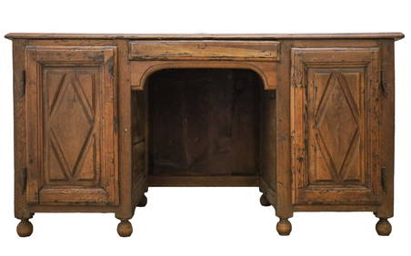
18th C WILLIAM AND MARY PANELED OAK CHEST ON STANDLewis & Maese Antiques & Auction4.4(527)See Sold PriceFeb 25, 2024
Two (2) Antique 18th C. Copper Engraved Framed Maps - America & EuropeMagnusson Art Group4.5(53)See Sold PriceMar 14, 2024
Map: An 18thC engraved and hand coloured map of North America and South America, titled DeClaydon Auctioneers Ltd4.3(125)See Sold PriceFeb 26, 2024
1758 MAP PARTIE DE LA MER GLACIALE contenants La Nouvelle Zemble RUSSIA antiqueJasper524.5(9.9k)See Sold PriceFeb 27, 2024
Chinese Export Porcelain Teapots, Creamer & Plate, Ca. 18th C., H 5.75" W 4.5" L 6" 4 pcsDuMouchelles4.6(830)See Sold PriceMar 14, 2024
French Double Barrel Flintlock Shotgun, 20 Ga., Ca. 18th C., L 50.5"DuMouchelles4.6(830)See Sold PriceMar 14, 2024
French Double Barrel Flintlock Shotgun. 20 Ga., Ca. Later 18th C., L 48"DuMouchelles4.6(830)See Sold PriceMar 14, 2024
French Flintlock Double Barrel Fowler, Olive of Marsaille, Ca. Late 18th C., 24 Ga. (.570 Cal.) LDuMouchelles4.6(830)See Sold PriceMar 14, 2024
French Flintlock Double Barrel Shotgun, 20 Ga., Ca. 18th C., L 47.5"DuMouchelles4.6(830)See Sold PriceMar 14, 2024