Map of the Near East. Giovanni Batista & GiorgioTabula Asiae IIII. Map of the Near East. According to Ptolemy. By Giovanni Batista & Giorgio Galignani. From: Geografia cioe Descrittione Universale della Terra. Venice, 1598, 12. Page spread. The HolSee Sold Price
SoldMap of the Near East. Giovanni Batista & GiorgioTabula Asiae IIII. Map of the Near East. According to Ptolemy. By Giovanni Batista & Giorgio Galignani. From: Geografia cioe Descrittione Universale della Terra. Venice, 1598, 12. Page spread. The HolSee Sold Price
Map of the Near East. Giovanni Albrizzi. Venice, 1740.Irak Arabi Kurdistan Diarbek Turcomannia Siria e Palestina. Copperplate engraving. Black and white. By Giovanni Albrizzi. Venice, 1740.Latin. 27×33.5 cm. (38.5×48.5 inclusive). Very fine condiSee Sold Price
Map of the Near East. Giovanni Albrizzi. Venice, 1740.Irak Arabi Kurdistan Diarbek Turcomannia Siria e Palestina. Copperplate engraving. Black and white. By Giovanni Albrizzi. Venice, 1740. Latin. 27x33.5 cm. (38.5x48.5 inclusive). Very fine condition. QSee Sold Price
ASIA. The Near East. Industries and Communications 1907 old antique map chartTITLE/CONTENT OF MAP: 'The Near East: Industries and Communications' DATE PRINTED: 1907 IMAGE SIZE: Approx 36.0 x 48.5cm, 14 x 19 inches (Large); Please note that this is a folding map. TYPE: Colour aSee Sold Price
Sold12 Mid Century Educational Wall Maps,12 Mid Century Educational Wall Maps Mostly historical European Maps and Near East/ Mesopotamian Topics, All approx 47" Two With Spring loaded hangers,See Sold Price
Blaeu 1647 Map of Near & Middle EastDESCRIPTION: This map, created by Willem Blaeu and Joan Blaeu, features a title cartouche "Turcicum Imperium" showing a Turkish Sultan on his throne, flanked by armed allegorical figures. Also includeSee Sold Price
SoldMap of the Near East through Muscovy. 19th Century?Map of the Near East. The Holy Land, Egypt, Antolia, the Black Sea in the west; Georgia, Astrakhan in the east; Muscovy in the north; and the Arabian Peninsula in the south. Copperplate engraving. BlaSee Sold Price
SoldMap of the Near East. Halma Francois. Holland, 1707Descriptio Paradisi et Terrae Canaan regionumque a Patriachis primum habitatarum. Map of the Garden of Eden and the Holy Land. Includes the Holy Land in the west through Babylon and the Euphrates in tSee Sold Price
Sold3 Middle & Near East Maps, plus Text Sheet & Carved Heraldic Wall Plaque, 5 items1st item: DE BESCHRYVING VAN DE REYSEN PAULI, EN VAN DE ANDERE APOSTELEN map, engraved by Daniel Stoopendaal after Bastian Stoopendaal, published by Pieter and Jacob Keur, Amsterdam, ca. 1730. CopperpSee Sold Price
SoldStoopendaal 1729 Map of Near & Middle EastDESCRIPTION: "De Gelegentheyt Paradys en't Landt Canaan, Mitsgaders d' Eerst Bewoonde Landen der Patriarchen." This Dutch Bible map features region between the Mediterranean and the Persian Gulf. InclSee Sold Price
Map of the Near East. Cluver Philip. Leiden, c. 1660.Persia sive Sophorum regnum com Armenia Assyria Mesopotamia et Babilonia. Map of the Near East through India in the east, the Holy Land in the west, the Caspian Sea in the north and the Arabian DesertSee Sold Price
Map of the Near East. D'Anville Jean BaptistL'Orient pour l'Histooire Ancienne de Rollin par D'Anville Geographe ordinaire du Roi. Map of the Holy Land and the Near East thorugh the Persian Gulf. By D'Anville Jean Baptist Bourguignon, 1760. InSee Sold Price
Map of the Near East. Conrad Malte-Brun. Paris, 1812.Geographie des Hebreux. The geography of the Jews in the Near East from the Holy Land through the Arabian Peninsula, Persia and Medie. From: Malte-Brun Conard, Atlas Complet du precis de la geographieSee Sold Price
Map of the Near East. Jacob Andreas Friderich. 1733.Pardisus/Dar Paradies. The Garden of Eden according to Genesis, Chapter 1; 10, 11, 13, 14. Map of the Holy Land and the Near East. Copperplate engraving. Black and white. Engraver's name in the bottomSee Sold Price
Map of the Near East. Sebastian Munster. Basle, 1542.Tbula Asiae V. Map of the Near East from Mesopotamia and Babylon through Parthia and from the Persian Gulf through the Caspian Sea. Holy sites are marked. Woodcut shaped like a trapezoid. Black and whSee Sold Price
SoldMap of the Near East. Sebastian Munster. Basle, 1542.Tbula Asiae V. Map of the Near East from Mesopotamia and Babylon through Parthia and from the Persian Gulf through the Caspian Sea. Holy sites are marked. Woodcut shaped like a trapezoid. Black and whSee Sold Price
SoldMap of the Near East. D’Anville Jean BaptistL’Orient pour l’Histooire Ancienne de Rollin par D’Anville Geographe ordinaire du Roi. Map of the Holy Land and the Near East thorugh the Persian Gulf. By D’Anville Jean BaSee Sold Price
Map of the Near East in Relation to the Ancient World.Partie Orientale de la Carte des Anciennes Monarchies. Map of the Near East through India. Copperplate engraving. Colored borders. Small inset map in the upper right corner of the modern world: EuropeSee Sold Price
Map of the Near East. Halma Francois. Holland, 1707.Descriptio Paradisi et Terrae Canaan regionumque a Patriachis primum habitatarum. Map of the Garden of Eden and the Holy Land. Includes the Holy Land in the west through Babylon and the Euphrates in tSee Sold Price
Map of the Near East. Girolamo Ruscelli. Venice, 1562.Tabula Asiae IIII. Map of the Near East according to Ptolemy. By Giorlamo Ruscelli. From: Ptolemaeus Claudius, Geographia. Venice, 1562. P. 46-47. Page spread from the Holy Land in the west through BaSee Sold Price
Map of the Near East. Gastaldi Giacomo. Venice, 1599.Tabula Asiae IIII. Map of the Near East. According to Ptolemy. By Giacomo Gastaldi. From: Ptolemaeus Claudius, Geographia. Venice, 1599, p 129. Published by Heredi di Melchior Sessa. Page spread. TheSee Sold Price
SoldOrtelius: Three maps of the Near EastThree maps printed from a single engraved plate, from Theatrum Orbis Terrarum, Antwerp, 1598: "'Natoliae, Quae Olim Asia Minor, Nova Descriptio;" "Aegypti Recentior Descriptio …;" "and "CarthaginisSee Sold Price
Aa (P. van der) 3 maps of the Near EastAa (Pieter van der) Babylonie en Balsara van Aleppo,Arabia to the Malay peninsula; with De Roode Zee met de kusten van Arabien, the Red Sea, Arabia and East Africa; also with M. Heberers OngelSee Sold Price
Spanish school of the XIX century. Follower of GIOVANNI BATISTA SALVI "IL SASSOFERRATO"Setdart Auction House4.1(22)See Sold PriceFeb 28, 2024
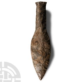
Stone Age Classic British Teardrop-Shaped Knapped Flint HandaxeTimeLine Auctions Ltd.4.5(183)See Sold PriceMar 05, 2024
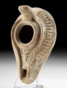
Stone Age British Grey and White Knapped Flint Ficron HandaxeTimeLine Auctions Ltd.4.5(183)See Sold PriceMar 05, 2024
Stone Age Classic Teardrop-Shaped Knapped Flint HandaxeTimeLine Auctions Ltd.4.5(183)See Sold PriceMar 05, 2024
Large Stone Age 'Somme' White Knapped Flint HandaxeTimeLine Auctions Ltd.4.5(183)See Sold PriceMar 05, 2024
WEST AFRICA Explorers' routes Senegal Ashanti. Mountains of Kong. SDUK 1857 mapJasper524.5(9.8k)See Sold PriceFeb 28, 2024
WEST AFRICA explorers' routes. Beaufort Gray Park Dochard Caillie. SDUK 1874 mapJasper524.5(9.8k)See Sold PriceFeb 28, 2024
WEST AFRICA I Explorers' routes Senegal Ashanti Ivory Gold Coast. SDUK 1851 mapJasper524.5(9.8k)See Sold PriceFeb 28, 2024
WEST AFRICA showing early explorers' routes & Mountains of Kong. SDUK 1844 mapJasper524.5(9.8k)See Sold PriceFeb 28, 2024
PRE COLONIAL WESTERN AFRICA. Shows Mountains of Kong. Tribes. WELLER 1863 mapJasper524.5(9.8k)See Sold PriceFeb 28, 2024
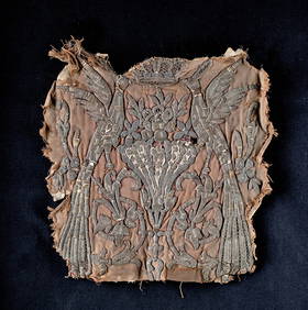
12th C. Egyptian Mamluk Linen / Silk Textile PanelArtemis Fine Arts4.8(1.4k)See Sold PriceFeb 26, 2024
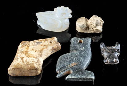
3 Bactrian, Urartu, & Achaemenid Stone Stamp Seal BeadsArtemis Fine Arts4.8(1.4k)See Sold PriceFeb 26, 2024
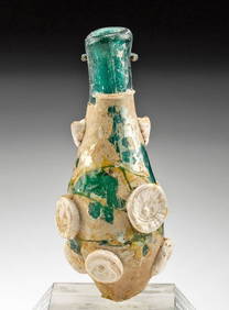
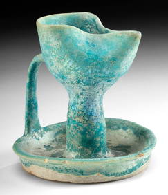
Roman / Byzantine Oil Lamp - Interesting IconographyArtemis Fine Arts4.8(1.4k)See Sold PriceFeb 26, 2024
3 Sassanian Stamp Seals (Carnelian, Red Jasper, Bronze)Artemis Fine Arts4.8(1.4k)See Sold PriceFeb 26, 2024