Map of the Near East. Cluver Philip. Leiden, c. 1660.Persia sive Sophorum regnum com Armenia Assyria Mesopotamia et Babilonia. Map of the Near East through India in the east, the Holy Land in the west, the Caspian Sea in the north and the Arabian DesertSee Sold Price
Philip Cluver - Isles de L'inde OrientalePhilip Cluver - Isles de L'inde Orientale Scarce map of the East Indies by Philip Cluver. Originally issued in the early 1600s, this is a reissue from the early 18th century. With outline hand-colorinSee Sold Price
Cluver maps of Europe and GreeceHeading: Author: Cluver, Philip Title: Two maps by Philip Cluver Place Published: Leiden Publisher: Date Published: 17th century Description: Includes:See Sold Price
SoldNear East.- Conder (Lt. C.R.) and Lt. H.H. Kitchener.Near East.- Conder (Lt. C.R.) and Lt. H.H. Kitchener. Map of Palestine in 26 Sheets from Surveys conducted for the Committee of the Palestine Exploration Fund during the years 1872-1877, subscriber'sSee Sold Price
SoldNear East.- Conder (Lt. C.R.) Four "Special Edition"Near East.- Conder (Lt. C.R.) and Lt. H.H. Kitchener. Four "Special Edition" maps of Western Palestine, from Surveys conducted for the Committee of the Palestine Exploration Fund, including the maps 'See Sold Price
PhilipsTitle/Content of Map: Philips' Regional Wall Map of the Near East and Middle East (Land of the Five Seas) Cartographer: FULLARD, HAROLD Date: c1956 Publisher: GEORGE PHILIP & SON, LTD. Size: 45HeightSee Sold Price
''Philips' Tape Indicator Map of London,'' near f[Britain: London]. Philips' Tape Indicator Map Of London. Lon: George Philip & Son, c.1950. 23 3/4 x 36 1/21 in. Backed with linen, folded, bound in publisher's green cloth, with attached tape measureSee Sold Price
Sold4 maps-- Biblical topics; 1731, others Ca. 18th C[NEAR EAST]. 4 Maps. Mid-18th century, titles and cartouches in Italian. Only one map dated. Matted and framed. Largely very good condition. ++ Mappa Del Luogo Piu Probabile Del Giardino Di Eden, DelSee Sold Price
The Near East. Jan, Luyken. France, c. 1732Carte dela Situation du Paradis Terrestre.../Kaart van de Stant van het Aardsch Paradys. Map of the Holy Land and the Near East. Abraham's journey from Ur to Nablus. According to Pierre Daniel Heut. BSee Sold Price
SoldJanvier map, L'Asie c.1771-1783[Asia]. Jean Janvier. L'Asie Divisee En Ses Principaux Etats. Double-page engraved map showing both Near and Far East and including the East Indies. Paris: Lattre & Delalain, c.1771-1783. 11 7/8 x 17See Sold Price
SoldVarious. 16 maps of the Middle East. 17-19th cent.[Near/ Middle East] 16 maps. Various maps of the Near and Middle East, mostly 19th century. (1) [After Ptolemy] “Tabula Asiae V.” c. 17th century. Weller, Edward. (2) “The Isthmus ofSee Sold Price
Soldc. 1915, WWI Color Poster: Save The SurvivorsPosters“Where The Victims Are, Save The Survivors, 3,950,000 Starving People” c. 1915, WWI, “American Committee For Relief In The Near East” Color Poster and Detailed Map, ChoiSee Sold Price
SoldTabula Italiae Corsicae...[Europe/Italy]. Tabula Italiae Corsicae Sardiniae et Adjacentium Regnorum. Folding map. Anonymous. Attributed to Gerard Mercator or Philip Cluver. [Ca. 1630’s to 1660’s.] At outer edge of border:See Sold Price
Rendsburgum Map, J. Mejer C. 1660Rendsburgum, Chilonium et Bordesholma. Colored copper engraving. C. 1660, Amsterdam.See Sold Price
1730 Toms Map North East Africa -- Aegyptus etTitle/Content of Map: 1730 Toms Map North East Africa -- Aegyptus et Cyrenaica Date: 1730 c. Cartographer: W Toms Size: 8 x 11.9 in. This map, after Cluver and deFer, shows the Mediterranean coast froSee Sold Price
Toms: Antique Map North East Africa, 1730Title/Content of Map: 1730 Toms Map North East Africa -- Aegyptus et Cyrenaica Date Printed: 1730 c. Cartographer: W Toms Size: 8 x 11.9 in. This map, after Cluver and deFer, shows the Mediterranean cSee Sold Price
Toms: Antique Map North East Africa, 1730Title/Content of Map: 1730 Toms Map North East Africa -- Aegyptus et Cyrenaica Date Printed: 1730 c. Cartographer: W Toms Size: 8 x 11.9 in. This map, after Cluver and deFer, shows the Mediterranean cSee Sold Price
1730 Toms Map North East Africa -- Aegyptus etTitle/Content of Map: 1730 Toms Map North East Africa -- Aegyptus et Cyrenaica Date: 1730 c. Cartographer: W Toms Size: 8 x 11.9 in. This map, after Cluver and deFer, shows the Mediterranean coast froSee Sold Price
1730 Toms Map North East Africa -- Aegyptus et CyrenaicaTitle: 1730 Toms Map North East Africa -- Aegyptus et Cyrenaica Cartographer: W Toms Year / Place: 1730 c. Map Dimension (in.): 8 x 11.9 in. This map, after Cluver and deFer, shows the Mediterranean cSee Sold Price
1730 Toms Map North East Africa -- Aegyptus etTitle/Content of Map: 1730 Toms Map North East Africa -- Aegyptus et Cyrenaica Date: 1730 c. Cartographer: W Toms Size: 8 x 11.9 in. This map, after Cluver and deFer, shows the Mediterranean coast froSee Sold Price
1730 Toms Map North East Africa -- Aegyptus etTitle/Content of Map: 1730 Toms Map North East Africa -- Aegyptus et Cyrenaica1730 c. Cartographer: W Toms Size: 8 x 11.9 in. This map, after Cluver and deFer, shows the Mediterranean coast from the RSee Sold Price
1730 Toms Map North East Africa -- Aegyptus etTitle/Content of Map: 1730 Toms Map North East Africa -- Aegyptus et Cyrenaica Cartographer: W Toms Year/Place: 1730 c. Size: 8 x 11.9 in. This map, after Cluver and deFer, shows the Mediterranean coaSee Sold Price
1730 Toms Map North East Africa -- Aegyptus etTitle/Content of Map: 1730 Toms Map North East Africa -- Aegyptus et Cyrenaica Date: 1730 c. Cartographer: W Toms Size: 8 x 11.9 in. This map, after Cluver and deFer, shows the Mediterranean coast froSee Sold Price
1730 Toms Map North East Africa -- Aegyptus etTitle/Content of Map: 1730 Toms Map North East Africa -- Aegyptus et Cyrenaica Date Printed: 1730 c. Cartographer: W Toms Size: 8 x 11.9 in. This map, after Cluver and deFer, shows the Mediterranean cSee Sold Price
EARLY 18TH C. MAP OF ITALY, FRAMEDThomaston Place Auction Galleries4.4(393)See Sold PriceFeb 24, 2024
LATE 16TH C. MAP OF SCOTLAND BY MERCATOR, FRAMEDThomaston Place Auction Galleries4.4(393)See Sold PriceFeb 24, 2024
17TH C. MAP OF THE BERKSHIRES BY JOHN SPEED, FRAMEDThomaston Place Auction Galleries4.4(393)See Sold PriceFeb 24, 2024
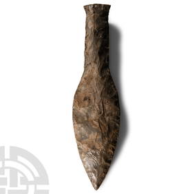
Stone Age Classic British Teardrop-Shaped Knapped Flint HandaxeTimeLine Auctions Ltd.4.6(183)See Sold PriceMar 05, 2024
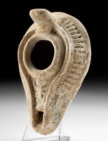
Stone Age British Grey and White Knapped Flint Ficron HandaxeTimeLine Auctions Ltd.4.6(183)See Sold PriceMar 05, 2024
Stone Age Classic Teardrop-Shaped Knapped Flint HandaxeTimeLine Auctions Ltd.4.6(183)See Sold PriceMar 05, 2024
Tour of the Dutch East Indies, with exceptional platesPBA Galleries4.7(385)See Sold PriceMar 07, 2024
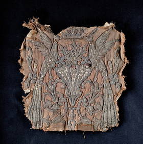
12th C. Egyptian Mamluk Linen / Silk Textile PanelArtemis Fine Arts4.8(1.4k)See Sold PriceFeb 26, 2024
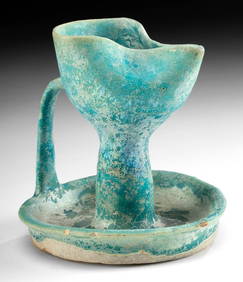
Roman / Byzantine Oil Lamp - Interesting IconographyArtemis Fine Arts4.8(1.4k)See Sold PriceFeb 26, 2024
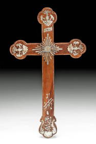
19th C. Asian Rosewood Apostle's Cross, Nacre InlayArtemis Fine Arts4.8(1.4k)See Sold PriceFeb 26, 2024
ALDRO T. HIBBARD, OIL, VERMONT WINTER LANDSCAPE.William Smith Auctions4.6(147)See Sold PriceMar 06, 2024