ATLAS of ANTIENT GEOGRAPHY by SAMUEL BUTLER 1843John McInnis Auctioneers,LLC4.6(502)See Sold PriceFeb 24, 2024
18TH C. ANTIQUE MAP: FRENCH & INDIAN WAR, FRAMEDThomaston Place Auction Galleries4.4(386)See Sold PriceFeb 24, 2024
Rand McNally Railroad Map Cabinet w/ 21 Railroad MapsRail & Road Auctions4.6(165)See Sold PriceMar 08, 2024
Keith Haring - Ink on New York Map, Best Buddies, Inscribed, Signed, and DatedSapphire Auction Gallery4(67)See Sold PriceMar 02, 2024
LATE 17TH C. FRENCH MAP OF THE NEW WORLD BY ALEXIS-HUBERT JAILLOT (1632-1712)Thomaston Place Auction Galleries4.4(386)See Sold PriceFeb 24, 2024
Central Railroad of New Jersey Map of Sandy Hook Route-ca. 1903JM Hobby Supply and Railroad Artifact Auctions4.4(126)See Sold PriceFeb 24, 2024
Lot of Six Mixed Atlas Box Cars-HO Scale-New in BoxJM Hobby Supply and Railroad Artifact Auctions4.4(126)See Sold PriceFeb 25, 2024
Rand McNally/Santa Fe Railroad Map of Iowa-1912JM Hobby Supply and Railroad Artifact Auctions4.4(126)See Sold PriceFeb 24, 2024
NICOLAES VISSCHER (NETHERLANDS, 1618-1709) MAP OF THE NEW WORLDThomaston Place Auction Galleries4.4(386)See Sold PriceFeb 24, 2024
17TH C. WORLD MAP BY NICOLAES VISSCHER (NETHERLANDS, 1618-1709)Thomaston Place Auction Galleries4.4(386)See Sold PriceFeb 24, 2024
Lot of Six Mixed Atlas Cabooses-HO Scale-New in BoxJM Hobby Supply and Railroad Artifact Auctions4.4(126)See Sold PriceFeb 25, 2024
Carey & Lea: Antique Map of the Americas, 1827Title/Content of Map: Geographical, Statistical and Historical Map of America Publication Date: 1827 Authors: CAREY & LEA Publisher: CAREY & LEA Size: Double Folio – 8.50 H x 15.00 W Inches TwoSee Sold Price
Sold[Hood's Tennessee Campaign] andLatour's [Historical Memoir of the War] Thomas Robson Hay, [Hood's Tennessee Campaign,] New York, 1929, with four maps (two fold out), Howe's H-336, 9-1/4 x 6 in., [two ownership stamps on front freeSee Sold Price
SoldRobert Elliot. 2 vols. Views in the East. 1833.[Asia] Elliot, Robert. Views in the East; Comprising India, Canton, and the Shores of the Red Sea. With Historical and Descriptive Illustrations. London: H. Fisher, Son, & Co., 1833. 4to. Two volumes.See Sold Price
SoldTwo historical maps of thTwo historical maps of the 17th century from Lithuania and Rügen, ''Magni Ducatus Lithuaniae et Regionum Adiacentium exacta Descriptio ...'', partly col. Copper engraving with title cartouche at BlaeSee Sold Price
SoldOrtelius, two historicalOrtelius, two historical maps of Indonesia and Greece from the ''Theatrum Orbis Terrarum'' around 1580, ''Indiae orientalis Insularumque Adiacientium type'' and ''Graeciae universae secundum hodiernumSee Sold Price
SoldTwo American Maps, H. Moll & Bellin, 1695 and 1757Grouping of two maps of America including, Item 1: Herman Moll (1654 -1732) "A Map of the English Plantations in America." Depicts the Americas from New England to South America. Published London, 169See Sold Price
SoldGeographical Statistical Historical Louisiana Map, 1822Map: Geographical, Statistical and Historical Map of Louisiana Cartographer: H Carey & I Lea Publishing: Philadelphia, 1822 Size: 16.5 x 21 inches This is a great colored map of Louisiana, from CareySee Sold Price
SoldTwo 18th century historicTwo 18th century historical maps of France and England, ''Regnorum Magnae Britanniae sive Angliae Scotiae ...'', Bordercol. Copper engraving with figurative cartouche Detail map of the Orkney Islands,See Sold Price
SoldANTIQUE GERMAN MAPS, TWO PIECESANTIQUE GERMAN MAPS, TWO PIECES, H 13", W 17":Including one framed engraving depicting North America; noted in German in the upper left "After the drawing by William Delisle, published by Joh Justin GSee Sold Price
SoldMap, Revolutionary War, BostonThis is a hand-tinted Revolutionary War map of Boston harbor. It was published in London in 1806 as part of a George Washington historical tribute. Map Size: 13" H. x 17" W. Framed Size: 14.75" H. x 1See Sold Price
SoldTwo MapsTwo reproductions of historical United States maps. One reproduction of Captain John Smith's map of Virginia produced from an engraving held by the Library of Congress. Sight size 15 1/2 x 18 1/2 inchSee Sold Price
SoldCarol Pongrasic Mugs, Figures & Busts DollhouseCarol Pongrasic group of dollhouse miniatures, thirteen historical figural mugs average .5"H, three historical bisque busts, two sets of minuet dancers, two ladies and four pieces of white cookwareSee Sold Price
SoldGROUPING OF MAPS(3) pieces including contemporary map of New England in gold frame, and two French lithograph maps. Dimensions: (Largest) (Frame) H 24.5" x W 18.5" Condition: Crack to glass of largest. No issues to oSee Sold Price
SoldDisenos of California Ranchos by Robert BeckerTitle: Designs on the Land: Diseños of California Ranchos and their Makers Author: Becker, Robert H. Description: 64 California maps, two folding. (Oblong folio) 14x18, brown suede-backed cloth; spinSee Sold Price
SoldTwo 17th Century Maps, Astrological and TerrestrialTwo 17th Century Maps, Astrological and Terrestrial17 in. h. x 20 in. w., image 24 in. h. x 26 in. w., as framedSee Sold Price
SoldJOHANNES WALCH, AUGSBURG, BAVARIA ENGRAVED WORLD MAPSJOHANNES WALCH, AUGSBURG, BAVARIA ENGRAVED WORLD MAPS C. 1802 TWO H 10" W 8" Each map measures 10 1/2" x 8 1/2". Plate marks. One frame; 27 3/4" x 15". Johannes Walch 1757 - 1816 was an artist, engravSee Sold Price
SoldRapkin: Western Hemisphere Eastern HemisphereTitle/Content of Map: Western Hemisphere Eastern Hemisphere Date Printed: 1850 ca. Cartographer: J. Rapkin Size: Each hemisphere is 9" diameter, the page is 19.25"W. x 11"H Two circular hemisphere mapSee Sold Price
SoldPoster. MIGUEL COVARRUBIAS. PAGEANT OF THE PACMIGUEL COVARRUBIAS. PAGEANT OF THE PACIFIC. Group of 6 poster maps. 1940. Sizes vary, two maps 19x25 inches, three maps 25x38 inches. H. S. Crocker. Condition varies, generally A-. Paper. TheSee Sold Price
SoldTilt Top Regency Map ChestTilt top Regency map chest with embossed leather top having six drawers and brass pulls, made in two equal parts, map case, 34 1/2"h x 46 1/2"w x 34"d. Good condition. Provenance: One of sixty made foSee Sold Price
SoldTwo Maps by Willem Janszoon Blaeu (1571-1638),Two Maps by Willem Janszoon Blaeu (1571-1638), "Virginiae partis australis et Florida partis orientalis," 1640, hand colored, H. - 15 in., W. - 20 in.; together with India Quae Orientalis Diktur et InSee Sold Price
SoldTwo Maps by Jean Baptiste D'Anville (1699-1782), "Two Maps by Jean Baptiste D'Anville (1699-1782), " America Septentrionales, Coloniis lnteriorem Virginiam deductis, Ohio," 1756 and 1777, H. - 20 in., W. - 23 5/8 in. (2 Pcs.)See Sold Price
SoldTwo Maps by Olfert Dapper (1636-1689), "Nova VirginiaTwo Maps by Olfert Dapper (1636-1689), "Nova Virginia Tabula, " 1650, H. - 12 1/4 in., W. - 15 in.See Sold Price
SoldTwo MapsOne a map of the West Indies, by Herman Moll, geographer, the other a chart of the waters for the America's Cup, October 31st, 1934. Sight sizes: 18"h x 24"w and 24-3/4"h x 40-3/4"wSee Sold Price
SoldTwo Historical Blue Staffordshire Plates "Commodore"Commodore Paul Jones Capturing the Serapis" and "The Exchange Baltimore" each 10" HSee Sold Price
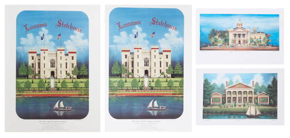
Jim Blanchard (American/Louisiana, b. 1955), Four Architectural Prints, 20th c., Smaller Prints-Crescent City Auction Gallery4.3(229)See Sold PriceMar 01, 2024
[PRE-FIRE CHICAGO IMPRINTS]. Group of Two Pre-Fire Broadsid...Potter & Potter Auctions4.6(539)See Sold PriceMar 07, 2024
“Miss Cubas”. Group of Two CDVs of...Potter & Potter Auctions4.6(539)See Sold PriceMar 07, 2024
Willem Blaeu, Etc. 17th C. Antiquarian Maps, 2Auctions at Showplace4.5(726)See Sold PriceMar 17, 2024
CARVER, George Washington (ca 1864-1943). Two TLsS ("G.W. Carver"), April and October 1936.[With:]Freeman's | Hindman4.4(1.6k)See Sold PriceFeb 27, 2024
TWO STAFFORDSHIRE HISTORICAL BLUE PIECES.Amelia Jeffers, Auctioneers & Appraisers4.6(101)See Sold PriceMar 08, 2024
Horace Wolfe Duesbury (American, 1851-1904) Two 1891 Oil on CanvasCV Auction LLC4.4(34)See Sold PriceMar 09, 2024
Jules Verne, Mirifiques Aventures de Maitre, Aux HarponsLion and Unicorn4.7(1.8k)See Sold PriceMar 03, 2024
Jules Verne, Mirifiques Aventures de Maitre, Aux HarponsLion and Unicorn4.7(1.8k)See Sold PriceMar 03, 2024
Two Hand-Colored 19th Century Maps of New Orleans and Louisiana, Larger- H.- 12 1/2 in., W.- 15 1/2Crescent City Auction Gallery4.3(229)See Sold PriceMar 08, 2024
Robert H Labberton - Map of The Territory of the Present United States - The territory of theProverde Auctions4.3(3)See Sold PriceFeb 28, 2024
Jules Verne, L'Archipel en Feu, Au Steamer Red MacaronLion and Unicorn4.7(1.8k)See Sold PriceMar 10, 2024
Angela Bing Jansen (American, B. 1929) Photoengraving, Etching And Aquatint on Wove Paper, 1972,DuMouchelles4.6(825)See Sold PriceMar 15, 2024


![[Hood's Tennessee Campaign] and (1 of 3)](https://p1.liveauctioneers.com/33/44680/19912164_1_x.jpg?height=282&quality=70&version=1378232798)


![[PRE-FIRE CHICAGO IMPRINTS]. Group of Two Pre-Fire Broadsid... (1 of 4)](https://p1.liveauctioneers.com/928/318880/171361167_1_x.jpg?height=282&quality=70&version=1707501302)


![CARVER, George Washington (ca 1864-1943). Two TLsS ("G.W. Carver"), April and October 1936.[With:] (1 of 2)](https://p1.liveauctioneers.com/197/319238/171467840_1_x.jpg?height=282&quality=70&version=1707520367)