ATLAS of ANTIENT GEOGRAPHY by SAMUEL BUTLER 1843John McInnis Auctioneers,LLC4.5(505)See Sold PriceFeb 24, 2024
18TH C. ANTIQUE MAP: FRENCH & INDIAN WAR, FRAMEDThomaston Place Auction Galleries4.4(393)See Sold PriceFeb 24, 2024
Rand McNally Railroad Map Cabinet w/ 21 Railroad MapsRail & Road Auctions4.6(165)See Sold PriceMar 08, 2024
Keith Haring - Ink on New York Map, Best Buddies, Inscribed, Signed, and DatedSapphire Auction Gallery4.1(67)See Sold PriceMar 02, 2024
LATE 17TH C. FRENCH MAP OF THE NEW WORLD BY ALEXIS-HUBERT JAILLOT (1632-1712)Thomaston Place Auction Galleries4.4(393)See Sold PriceFeb 24, 2024
Central Railroad of New Jersey Map of Sandy Hook Route-ca. 1903JM Hobby Supply and Railroad Artifact Auctions4.4(127)See Sold PriceFeb 24, 2024
Lot of Six Mixed Atlas Box Cars-HO Scale-New in BoxJM Hobby Supply and Railroad Artifact Auctions4.4(127)See Sold PriceFeb 25, 2024
Rand McNally/Santa Fe Railroad Map of Iowa-1912JM Hobby Supply and Railroad Artifact Auctions4.4(127)See Sold PriceFeb 24, 2024
NICOLAES VISSCHER (NETHERLANDS, 1618-1709) MAP OF THE NEW WORLDThomaston Place Auction Galleries4.4(393)See Sold PriceFeb 24, 2024
17TH C. WORLD MAP BY NICOLAES VISSCHER (NETHERLANDS, 1618-1709)Thomaston Place Auction Galleries4.4(393)See Sold PriceFeb 24, 2024
Lot of Six Mixed Atlas Cabooses-HO Scale-New in BoxJM Hobby Supply and Railroad Artifact Auctions4.4(127)See Sold PriceFeb 25, 2024
WORLD ON MERCATOR'S PROJECTION showing the BRITISH EMPIRE by GW BACON 1891 mapCAPTION PRINTED BELOW PICTURE: 'The World on Mercator's Projection' DATE PRINTED: 1891 IMAGE SIZE: Approx 32.5 x 51.0cm, 12.75 x 20 inches (Large); Please note that this is a folding map. TYPE: ColourSee Sold Price
World on Mercator's Projection showing the British Empire. BARTHOLOMEW 1862 mapTITLE OF PRINT (NOT PRINTED ON THE PAGE):'The World on Mercator's Projection' DATE PRINTED: 1862 IMAGE SIZE: Approx 44.0 x 58.5cm, 17.25 x 23 inches (Large); Please note that this is a folding map. TYSee Sold Price
World Mercator's on projection. India in relation to the British Empire 1909 mapTITLE/CONTENT OF MAP: 'Chart of the World on Mercator's Projection showing India in relation to the British Empire' DATE PRINTED: 1909 IMAGE SIZE: Approx 20.0 x 25.0cm, 7.75 x 10 inches (Medium); PleaSee Sold Price
World Mercator's on projection. India in relation to the British Empire 1931 mapCAPTION PRINTED BELOW PICTURE: 'Chart of the World on Mercator's Projection showing India in relation to the British Empire' DATE PRINTED: 1931 IMAGE SIZE: Approx 20.5 x 25.0cm, 8 x 10 inches (Medium)See Sold Price
WORLD ON MERCATOR'S PROJECTION. British Empire. Telegraph cables. LETTS 1883 mapTITLE/CONTENT OF MAP: 'The World, on Mercator's Projection' DATE PRINTED: 1883 IMAGE SIZE: Approx 43.0 x 67.5cm, 17 x 26.5 inches (Large); Please note that this is a folding map. TYPE: Antique colourSee Sold Price
World on Mercator's Projection. British Empire in Pink. STANFORD c1925 old mapCAPTION PRINTED BELOW PICTURE: 'The World, on Mercator's Projection' DATE PRINTED: The map is undated; we estimate publication at either 1924 or 1925 based on the content of the maps within the atlasSee Sold Price
World on Mercator's Projection by John Dower. British Empire in pink 1876 mapTITLE/CONTENT OF MAP: 'The World on Mercator's Projection By John Dower F.R.G.S. N.B. British Possessions are colored red' DATE PRINTED: 1876 IMAGE SIZE: Approx 34.5 x 52.0cm, 13.5 x 20.5 inches (LargSee Sold Price
SoldJigsaw. Philip (George, & Son) - Double-sided jigsaw2 jigsaw maps, Europe and Scotland, each with the world on Mercator's projection on verso, colour-printed maps mounted on wood and dissected, unboxed ; with a G.W. Bacon map of Canada, backed with theSee Sold Price
WORLD MERCATOR showing mail routes to British colonies. RAPKIN/TALLIS 1851 mapTITLE/CONTENT OF MAP: 'The World on Mercator's Projection' Vignettes: Vesuvius; Gibraltar; London; Constantinople; Niagara; The Pyramids of Ghizeh; Pont Neuf, Paris. The steam ship routes to the colonSee Sold Price
BRITISH EMPIRE. Shows steam routes to theTITLE/CONTENT OF MAP: 'The World on Mercator's Projection' Vignettes: Vesuvius; Gibraltar; London; Constantinople; Niagara; The Pyramids of Ghizeh; Pont Neuf, Paris. The steam ship routes to the colonSee Sold Price
BRITISH EMPIRE. Shows steam routes to the colonies.World. RAPKIN/TALLIS 1851 mapCAPTION PRINTED BELOW PICTURE: 'The World on Mercator's Projection' Vignettes: Vesuvius; Gibraltar; London; Constantinople; Niagara; The Pyramids of Ghizeh; Pont Neuf, Paris. The steam ship routes toSee Sold Price
BRITISH EMPIRE. Shows steam routes to theTITLE/CONTENT OF MAP: 'The World on Mercator's Projection' Vignettes: Vesuvius; Gibraltar; London; Constantinople; Niagara; The Pyramids of Ghizeh; Pont Neuf, Paris. The steam ship routes to the colonSee Sold Price
BRITISH EMPIRE. Shows steam routes to theTITLE/CONTENT OF MAP: 'The World on Mercator's Projection'Vignettes: Vesuvius; Gibraltar; London; Constantinople; Niagara; The Pyramids of Ghizeh; Pont Neuf, Paris. The steam ship routes to the coloniSee Sold Price
BRITISH EMPIRE. Shows steam routes to theTITLE/CONTENT OF MAP: 'The World on Mercator's Projection' Vignettes: Vesuvius; Gibraltar; London; Constantinople; Niagara; The Pyramids of Ghizeh; Pont Neuf, Paris. The steam ship routes to the colonSee Sold Price
BRITISH EMPIRE. Shows steam routes to theTITLE/CONTENT OF MAP: 'The World on Mercator's Projection' Vignettes: Vesuvius; Gibraltar; London; Constantinople; Niagara; The Pyramids of Ghizeh; Pont Neuf, Paris. The steam ship routes to the colonSee Sold Price
BRITISH EMPIRE. Shows steam routes to the colonies.World. RAPKIN/TALLIS 1851 mapCAPTION PRINTED BELOW PICTURE: 'The World on Mercator's Projection' Vignettes: Vesuvius; Gibraltar; London; Constantinople; Niagara; The Pyramids of Ghizeh; Pont Neuf, Paris. The steam ship routes toSee Sold Price
WORLD MERCATOR showing mail routes to British colonies.TITLE/CONTENT OF MAP: 'The World on Mercator's Projection' Vignettes: Vesuvius; Gibraltar; London; Constantinople; Niagara; The Pyramids of Ghizeh; Pont Neuf, Paris. The steam ship routes to the colonSee Sold Price
WORLD MERCATOR showing mail routes to British colonies.TITLE/CONTENT OF MAP: 'The World on Mercator's Projection' Vignettes: Vesuvius; Gibraltar; London; Constantinople; Niagara; The Pyramids of Ghizeh; Pont Neuf, Paris. The steam ship routes to the colonSee Sold Price
WORLD MERCATOR showing mail routes to British colonies.TITLE/CONTENT OF MAP: 'The World on Mercator's Projection' Vignettes: Vesuvius; Gibraltar; London; Constantinople; Niagara; The Pyramids of Ghizeh; Pont Neuf, Paris. The steam ship routes to the colonSee Sold Price
WORLD MERCATOR showing mail routes to British colonies.TITLE/CONTENT OF MAP: 'The World on Mercator's Projection' Vignettes: Vesuvius; Gibraltar; London; Constantinople; Niagara; The Pyramids of Ghizeh; Pont Neuf, Paris. The steam ship routes to the colonSee Sold Price
SoldBRITISH EMPIRE. World Mercator. Currents. SteamshipTITLE/CONTENT OF MAP: 'The World (Mercator); Inset map of France' The top image on the right hand side shows the entire map. To view a close up of the map showing the level of printed detail, please cSee Sold Price
SoldWORLD/British Empire. 'Steam routes to the colonies'.TITLE/CONTENT OF MAP: 'The World on Mercator's Projection' Vignettes: Gibraltar; London; Constantinople; Niagara; The Pyramids of Ghizeh; Pont Neuf, Paris; Vesuvius. The steam ship routes to the colonSee Sold Price
SoldTeesdale (Henry) Chart of the WorldTeesdale (Henry) A New Chart of the World on Mercator's Projection, showing Texas as an independent state, engraved map on two sheets, unjoined, with full original hand-colouring, 1290 x 1935See Sold Price
WORLD. Mercator's projection. Ocean currents & shipping routes. BLACKIE 1882 mapTITLE/CONTENT OF MAP: 'The World on Mercators projection showing the courses of the chief ocean currents and the navigation tracks between the principal ports' DATE PRINTED: 1882 IMAGE SIZE: Approx 36See Sold Price
Union Pacific RR Across The Continent West From Omaha, NE Book-April 2, 1868JM Hobby Supply and Railroad Artifact Auctions4.4(127)See Sold PriceFeb 24, 2024
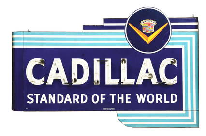
CADILLAC "STANDARD OF THE WORLD" PORCELAIN NEON SIGN.Dan Morphy Auctions4.2(1.3k)See Sold PriceFeb 24, 2024
17TH C. WORLD MAP BY NICOLAES VISSCHER (NETHERLANDS, 1618-1709)Thomaston Place Auction Galleries4.4(393)See Sold PriceFeb 24, 2024
LATE 17TH C. FRENCH MAP OF THE NEW WORLD BY ALEXIS-HUBERT JAILLOT (1632-1712)Thomaston Place Auction Galleries4.4(393)See Sold PriceFeb 24, 2024
LATE 16TH C. MAP OF SCOTLAND BY MERCATOR, FRAMEDThomaston Place Auction Galleries4.4(393)See Sold PriceFeb 24, 2024
NICOLAES VISSCHER (NETHERLANDS, 1618-1709) MAP OF THE NEW WORLDThomaston Place Auction Galleries4.4(393)See Sold PriceFeb 24, 2024
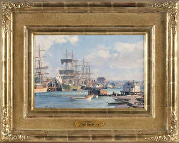
JOHN STOBART (Massachusetts/Florida/England, 1929-2023), "Victoria, View from Songhee Point, 1891".,Eldred's4.7(419)See Sold PriceFeb 27, 2024
FOUR CASED SETS OF WORLD WAR II-ERA U.S. NAVY RECOGNITION/TEACHING MODELS 20th Century Model lengthsEldred's4.7(419)See Sold PriceFeb 27, 2024
GROUPING OF (19th c) BRITISH SATIRICAL PRINTS etcJohn McInnis Auctioneers,LLC4.5(505)See Sold PriceFeb 24, 2024
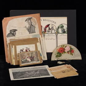
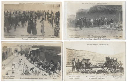
14 Official British Army Postcards - Palestine in WWILevy Auction House4.3(11)See Sold PriceFeb 27, 2024
Jerusalem Map for British Soldiers in Palestine - WW2Levy Auction House4.3(11)See Sold PriceFeb 27, 2024
18 Booklets Collection - War Graves of Palestine - WWILevy Auction House4.3(11)See Sold PriceFeb 27, 2024
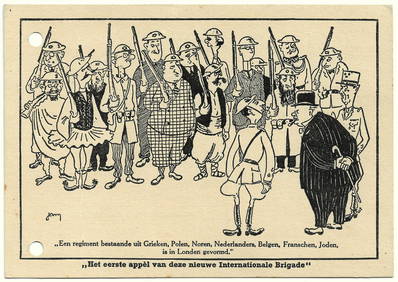
Antisemitic Postcard - Churchill's Jewish Army - WW2Levy Auction House4.3(11)See Sold PriceFeb 27, 2024
Vintage Full Color World Map LithographThe Benefit Shop Foundation Inc.4.3(2.9k)See Sold PriceFeb 28, 2024
Nova Totius Full Color Geographical World MapThe Benefit Shop Foundation Inc.4.3(2.9k)See Sold PriceFeb 28, 2024
After Benjamin Hudson "Lady In Blue Dress & HerWorld of Antiques, Inc.3.9(74)See Sold PriceFeb 29, 2024
ATTR TO LIBERTY COMPANY ARTS CRAFTS COPPER MIRRORAntique Arena Inc.4.5(878)See Sold PriceFeb 24, 2024
Arrowsmith & Lewis - Map of the World on Mercator's ProjectionTrillium Antique Prints & Rare Books4.5(32)See Sold PriceFeb 24, 2024
Carey, pub. 1796 - Map of KentuckyTrillium Antique Prints & Rare Books4.5(32)See Sold PriceFeb 24, 2024
Carey, pub. 1796 - Map of the Tennassee State formerly part of North Carolina (Tennessee)Trillium Antique Prints & Rare Books4.5(32)See Sold PriceFeb 24, 2024
De Jode, Rare, pub. 1593 - Map of Africa (Africae Vera Forma, et Situs)Trillium Antique Prints & Rare Books4.5(32)See Sold PriceFeb 24, 2024
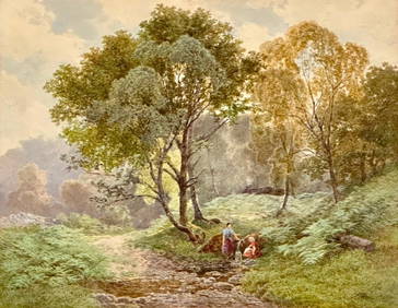
James Jackson Curnock Watercolor, Two Girls Gathering Water at the SpringNeue Auctions4.7(357)See Sold PriceMar 02, 2024
Blackie (Pub) 1882 Folio Map. World on Mercators ProjectionAlbion Auctions4.7(341)See Sold PriceMar 01, 2024