ATLAS of ANTIENT GEOGRAPHY by SAMUEL BUTLER 1843John McInnis Auctioneers,LLC4.6(502)See Sold PriceFeb 24, 2024
18TH C. ANTIQUE MAP: FRENCH & INDIAN WAR, FRAMEDThomaston Place Auction Galleries4.4(386)See Sold PriceFeb 24, 2024
Rand McNally Railroad Map Cabinet w/ 21 Railroad MapsRail & Road Auctions4.6(165)See Sold PriceMar 08, 2024
Keith Haring - Ink on New York Map, Best Buddies, Inscribed, Signed, and DatedSapphire Auction Gallery4(67)See Sold PriceMar 02, 2024
LATE 17TH C. FRENCH MAP OF THE NEW WORLD BY ALEXIS-HUBERT JAILLOT (1632-1712)Thomaston Place Auction Galleries4.4(386)See Sold PriceFeb 24, 2024
Central Railroad of New Jersey Map of Sandy Hook Route-ca. 1903JM Hobby Supply and Railroad Artifact Auctions4.4(126)See Sold PriceFeb 24, 2024
Lot of Six Mixed Atlas Box Cars-HO Scale-New in BoxJM Hobby Supply and Railroad Artifact Auctions4.4(126)See Sold PriceFeb 25, 2024
Rand McNally/Santa Fe Railroad Map of Iowa-1912JM Hobby Supply and Railroad Artifact Auctions4.4(126)See Sold PriceFeb 24, 2024
NICOLAES VISSCHER (NETHERLANDS, 1618-1709) MAP OF THE NEW WORLDThomaston Place Auction Galleries4.4(386)See Sold PriceFeb 24, 2024
17TH C. WORLD MAP BY NICOLAES VISSCHER (NETHERLANDS, 1618-1709)Thomaston Place Auction Galleries4.4(386)See Sold PriceFeb 24, 2024
Lot of Six Mixed Atlas Cabooses-HO Scale-New in BoxJM Hobby Supply and Railroad Artifact Auctions4.4(126)See Sold PriceFeb 25, 2024
FRANCE. Provinces. 'France par Gouvernmens Generaux'. MALLET 1683 old mapTITLE OF THE MAP: 'France par Gouvernmens Generaux' (De L'Europe) DATE PRINTED: 1683 IMAGE SIZE: Approx Overall page size 13 x 21cm approximately (5 x 8 inches); image size 10.5 x 14.5cm approximatelySee Sold Price
SoldMallet: Antique Map of France, 1683Title of the Map: 'France par Gouvernmens Generaux' Date Printed: 1683 Image Size: Approx Overall page size 13 x 21cm approximately (5 x 8 inches); image size 10.5 x 14.5cm approximately (4 x 5.5 inchSee Sold Price
FRANCE. 'Carte Generale'. Towns, rivers & provinces. MALLET 1683 old mapTITLE OF THE MAP: 'Carte Generale de France' (De L'Europe) DATE PRINTED: 1683 IMAGE SIZE: Approx Overall page size 26 x 21cm approximately (10 x 8 inches); image size 21 x 14.5cm approximately (8 x 5.See Sold Price
FRANCE. Regions Provinces Gouvernements'France en General'. MALLET 1683 mapTITLE OF THE MAP: 'France en General' (De L'Europe) DATE PRINTED: 1683 IMAGE SIZE: Approx Overall page size 13 x 21cm approximately (5 x 8 inches); image size 10.5 x 14.5cm approximately (4 x 5.5 inchSee Sold Price
CARTE GENERALE DE FRANCE' showing towns, rivers & provinces. MALLET 1683 mapTITLE OF THE MAP: 'Carte Generale de France' (De L'Europe) DATE PRINTED: 1683 IMAGE SIZE: Approx Overall page size 26 x 21cm approximately (10 x 8 inches); image size 21 x 14.5cm approximately (8 x 5.See Sold Price
MAP OF FRANCE. in regions. MALLET 1683 old antique vintage plan chartTITLE OF THE MAP: 'France' (Du Globe Terrestre) DATE PRINTED: 1683 IMAGE SIZE: Approx Overall page size 13 x 21cm approximately (5 x 8 inches); image size 10.5 x 14.5cm approximately (4 x 5.5 inches)See Sold Price
Mallet: Antique Map 'France en General', 1683Title of the Map: 'France en General' Regions Provinces Gouvernements Date Printed: 1683 Image Size: Approx Overall page size 13 x 21cm approximately (5 x 8 inches); image size 10.5 x 14.5cm approximaSee Sold Price
SoldMallet: Antique Map of France in Regions, 1683Title of the Map: 'France' MAP OF FRANCE. in regions. old antique vintage plan chart Date Printed: 1683 Image Size: Approx Overall page size 13 x 21cm approximately (5 x 8 inches); image size 10.5 x 1See Sold Price
Desnos/de la Tour: Antique Map Ecclestiastical FranceTITLE/CONTENT OF MAP: 'La France, divisée en ses quarante Gouvernemens Généraux et Militaires, dans leur étenduë actuelle et par Provinces Ecclésiastiques. Par Mr. Brion Ingénr. Géographe du RSee Sold Price
Desnos/de la Tour: Antique Map of France, 1771TITLE/CONTENT OF MAP: 'La France, divisée en ses quarante Gouvernemens Généraux et Militaires, dans leur étenduë actuelle et par Provinces Ecclésiastiques. Par Mr. Brion Ingénr. Géographe du RSee Sold Price
La France divisée en Gouvernemens. DESNOS/DE LA TOURTITLE/CONTENT OF MAP: 'La France, divisée en ses quarante Gouvernemens Généraux et Militaires, dans leur étenduë actuelle et par Provinces Ecclésiastiques. Par Mr. Brion Ingénr. Géographe du RSee Sold Price
La France divisée en Gouvernemens. DESNOS/DE LA TOURTITLE/CONTENT OF MAP: 'La France, divisée en ses quarante Gouvernemens Généraux et Militaires, dans leur étenduë actuelle et par Provinces Ecclésiastiques. Par Mr. Brion Ingénr. Géographe du RSee Sold Price
CORSICA. 'Isle de Corse'. Elba. Decorative. France. MALLET 1683 old mapTITLE OF THE MAP: 'I(sle) de Corse' (De L'Europe) DATE PRINTED: 1683 IMAGE SIZE: Approx Overall page size 13 x 21cm approximately (5 x 8 inches); image size 10.5 x 14.5cm approximately (4 x 5.5 inchesSee Sold Price
BALKANS. Pannonie/Pannonia Illyria. Croatia Bosnia Serbia. MALLET 1683 old mapTITLE OF THE MAP: 'Pannonie et Illyrie' (De L'Europe) Pannonia was an ancient province of the Roman Empire bounded north and east by the Danube, coterminous westward with Noricum and upper Italy, andSee Sold Price
BALKANS. Pannonie/Pannonia Illyria. Croatia Bosnia Serbia. MALLET 1683 old mapTITLE OF THE MAP: 'Pannonie et Illyrie' (De L'Europe) Pannonia was an ancient province of the Roman Empire bounded north and east by the Danube, coterminous westward with Noricum and upper Italy, andSee Sold Price
BALKANS. Pannonie/Pannonia Illyria. Croatia Bosnia Serbia. MALLET 1683 old mapTITLE OF THE MAP: 'Pannonie et Illyrie' (De L'Europe) Pannonia was an ancient province of the Roman Empire bounded north and east by the Danube, coterminous westward with Noricum and upper Italy, andSee Sold Price
BENELUX & NE FRANCE. Burgundy. Comté/'Cercle de Bourgogne'. MALLET 1683 mapTITLE OF THE MAP: 'Cercle de Bourgogne' (De L'Europe) Includes Luxembourg. Belgium. Parts of France and Germany. DATE PRINTED: 1683 IMAGE SIZE: Approx Overall page size 13 x 21cm approximately (5 x 8See Sold Price
BENELUX & NE FRANCE. Burgundy. Comté/'Cercle de Bourgogne'. MALLET 1683 mapTITLE OF THE MAP: 'Cercle de Bourgogne' (De L'Europe) Includes Luxembourg. Belgium. Parts of France and Germany. DATE PRINTED: 1683 IMAGE SIZE: Approx Overall page size 13 x 21cm approximately (5 x 8See Sold Price
BENELUX & NE FRANCE. Burgundy. Comté/'Cercle de Bourgogne'. MALLET 1683 mapTITLE OF THE MAP: 'Cercle de Bourgogne' (De L'Europe) Includes Luxembourg. Belgium. Parts of France and Germany. DATE PRINTED: 1683 IMAGE SIZE: Approx Overall page size 13 x 21cm approximately (5 x 8See Sold Price
SoldAntique Hand-Colored Map of FranceAn Antique Hand-Colored Map of France, "Carte du Royaume de France, Divisee par Provinces", hand-colored copper plate engraved map, by Bourgoin, Paris, 1765, sight 14 in. x 17 in., attractively mattedSee Sold Price
SoldMallet: Antique Map of the World/France, 1683Title/Content of Map: 'Planisphere du Monde; France' FRANCE/WORLD. odd-shaped Australia close to southern continent. Date Printed: 1683 Image Size: Approx Overall page size 13 x 21cm approximately (5See Sold Price
La France Divisee Par Gouvernement GenerauxTitle/Content of Map: La France Divisee Par Gouvernement Generaux Date: 1750 Cartographer: ROBERT DE VAUGONDY, DIDIER Size: 6X6.1 "Par le Sr. Robert de Vaugondy avec privilege 1750" Please note that tSee Sold Price
SoldMallet: Antique Map of the World; France, 1683Map Title: 'Planisphere du Monde; France' FRANCE/WORLD. odd-shaped Australia close to southern continent. Date Printed: 1683 Image Size: Approx Overall page size 13 x 21cm approximately (5 x 8 inches)See Sold Price
Map of Old FranceHand tinted and engraved map of Old France published by the Librairie Classique d'Eugene BELIN a Paris. With inscription "Ancienne France Divisee en 32 gouvernements par M.M Drioux et Ch. Leroy". SighSee Sold Price
Jean PICART LE DOUX (1902-1982) d'après : Partie de service à thé-café et à dessert enValoir Pousse-Cornet4.3(4)See Sold PriceFeb 24, 2024
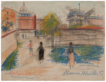
Maurice Utrillo (1883-1955), "Montmartre," Pastel with graphite and watercolor on paper laid toJohn Moran Auctioneers, Inc.4.7(453)See Sold PriceFeb 27, 2024
Duval - Pair: Map of Georgia & Map of Moscow, RussiaTrillium Antique Prints & Rare Books4.5(30)See Sold PriceFeb 24, 2024
Duval - Pair: Map of India & Map of MaldivesTrillium Antique Prints & Rare Books4.5(30)See Sold PriceFeb 24, 2024
WEST AFRICA Niger/Gambia rivers tribes towns. 'Pays des Negres'. MALLET 1683 mapJasper524.5(9.8k)See Sold PriceFeb 28, 2024
WEST CENTRAL AFRICA. Congo Angola Gabon Cameroon Sao Tome. MALLET 1683 old mapJasper524.5(9.8k)See Sold PriceFeb 28, 2024
NUBIA. 'Nubie'. Nile Valley. Sudan Ethiopia Egypt. MALLET 1683 old antique mapJasper524.5(9.8k)See Sold PriceFeb 28, 2024
SUB-SAHARAN AFRICA. 'Ancienne Ethiopie'. Ancient Ethiopia. MALLET 1683 old mapJasper524.5(9.8k)See Sold PriceFeb 28, 2024
SOUTHERN AFRICA Monomotapa (Mutapa Kingdom) Cafrerie (Kaffraria) MALLET 1683 mapJasper524.5(9.8k)See Sold PriceFeb 28, 2024
NICOLAS LEMERY'S 1717 PHARMACOPEIA IS AN OLD FRENCH PHARMACOLOGY TREATISE FROM THE 17TH CENTURY.NY Elizabeth 4.3(84)See Sold PriceMar 03, 2024
Paul Gavarni (France, 1804-1866). Emile Forgues, dit Old NickBonhams4.1(305)See Sold PriceMay 21, 2024


![Vintage Airplane Desk Model [Air France] (1 of 7)](https://p1.liveauctioneers.com/5755/320282/172113951_1_x.jpg?height=282&quality=70&version=1708463029)


