ATLAS of ANTIENT GEOGRAPHY by SAMUEL BUTLER 1843John McInnis Auctioneers,LLC4.5(505)See Sold PriceFeb 24, 2024
18TH C. ANTIQUE MAP: FRENCH & INDIAN WAR, FRAMEDThomaston Place Auction Galleries4.4(393)See Sold PriceFeb 24, 2024
Rand McNally Railroad Map Cabinet w/ 21 Railroad MapsRail & Road Auctions4.6(165)See Sold PriceMar 08, 2024
Keith Haring - Ink on New York Map, Best Buddies, Inscribed, Signed, and DatedSapphire Auction Gallery4.1(67)See Sold PriceMar 02, 2024
LATE 17TH C. FRENCH MAP OF THE NEW WORLD BY ALEXIS-HUBERT JAILLOT (1632-1712)Thomaston Place Auction Galleries4.4(393)See Sold PriceFeb 24, 2024
Central Railroad of New Jersey Map of Sandy Hook Route-ca. 1903JM Hobby Supply and Railroad Artifact Auctions4.4(127)See Sold PriceFeb 24, 2024
Lot of Six Mixed Atlas Box Cars-HO Scale-New in BoxJM Hobby Supply and Railroad Artifact Auctions4.4(127)See Sold PriceFeb 25, 2024
Rand McNally/Santa Fe Railroad Map of Iowa-1912JM Hobby Supply and Railroad Artifact Auctions4.4(127)See Sold PriceFeb 24, 2024
NICOLAES VISSCHER (NETHERLANDS, 1618-1709) MAP OF THE NEW WORLDThomaston Place Auction Galleries4.4(393)See Sold PriceFeb 24, 2024
17TH C. WORLD MAP BY NICOLAES VISSCHER (NETHERLANDS, 1618-1709)Thomaston Place Auction Galleries4.4(393)See Sold PriceFeb 24, 2024
Lot of Six Mixed Atlas Cabooses-HO Scale-New in BoxJM Hobby Supply and Railroad Artifact Auctions4.4(127)See Sold PriceFeb 25, 2024
World Mercator's on projection. India in relation to the British Empire 1931 mapCAPTION PRINTED BELOW PICTURE: 'Chart of the World on Mercator's Projection showing India in relation to the British Empire' DATE PRINTED: 1931 IMAGE SIZE: Approx 20.5 x 25.0cm, 8 x 10 inches (Medium)See Sold Price
World Mercator's on projection. India in relation to the British Empire 1909 mapTITLE/CONTENT OF MAP: 'Chart of the World on Mercator's Projection showing India in relation to the British Empire' DATE PRINTED: 1909 IMAGE SIZE: Approx 20.0 x 25.0cm, 7.75 x 10 inches (Medium); PleaSee Sold Price
WORLD ON MERCATOR'S PROJECTION. British Empire. Telegraph cables. LETTS 1883 mapTITLE/CONTENT OF MAP: 'The World, on Mercator's Projection' DATE PRINTED: 1883 IMAGE SIZE: Approx 43.0 x 67.5cm, 17 x 26.5 inches (Large); Please note that this is a folding map. TYPE: Antique colourSee Sold Price
World on Mercator's Projection showing the British Empire. BARTHOLOMEW 1862 mapTITLE OF PRINT (NOT PRINTED ON THE PAGE):'The World on Mercator's Projection' DATE PRINTED: 1862 IMAGE SIZE: Approx 44.0 x 58.5cm, 17.25 x 23 inches (Large); Please note that this is a folding map. TYSee Sold Price
World on Mercator's Projection. British Empire in Pink. STANFORD c1925 old mapCAPTION PRINTED BELOW PICTURE: 'The World, on Mercator's Projection' DATE PRINTED: The map is undated; we estimate publication at either 1924 or 1925 based on the content of the maps within the atlasSee Sold Price
WORLD ON MERCATOR'S PROJECTION showing the BRITISH EMPIRE by GW BACON 1891 mapCAPTION PRINTED BELOW PICTURE: 'The World on Mercator's Projection' DATE PRINTED: 1891 IMAGE SIZE: Approx 32.5 x 51.0cm, 12.75 x 20 inches (Large); Please note that this is a folding map. TYPE: ColourSee Sold Price
World on Mercator's Projection by John Dower. British Empire in pink 1876 mapTITLE/CONTENT OF MAP: 'The World on Mercator's Projection By John Dower F.R.G.S. N.B. British Possessions are colored red' DATE PRINTED: 1876 IMAGE SIZE: Approx 34.5 x 52.0cm, 13.5 x 20.5 inches (LargSee Sold Price
BRITISH EMPIRE. Shows steam routes to theTITLE/CONTENT OF MAP: 'The World on Mercator's Projection' Vignettes: Vesuvius; Gibraltar; London; Constantinople; Niagara; The Pyramids of Ghizeh; Pont Neuf, Paris. The steam ship routes to the colonSee Sold Price
BRITISH EMPIRE. Shows steam routes to the colonies.World. RAPKIN/TALLIS 1851 mapCAPTION PRINTED BELOW PICTURE: 'The World on Mercator's Projection' Vignettes: Vesuvius; Gibraltar; London; Constantinople; Niagara; The Pyramids of Ghizeh; Pont Neuf, Paris. The steam ship routes toSee Sold Price
BRITISH EMPIRE. Shows steam routes to theTITLE/CONTENT OF MAP: 'The World on Mercator's Projection' Vignettes: Vesuvius; Gibraltar; London; Constantinople; Niagara; The Pyramids of Ghizeh; Pont Neuf, Paris. The steam ship routes to the colonSee Sold Price
BRITISH EMPIRE. Shows steam routes to theTITLE/CONTENT OF MAP: 'The World on Mercator's Projection'Vignettes: Vesuvius; Gibraltar; London; Constantinople; Niagara; The Pyramids of Ghizeh; Pont Neuf, Paris. The steam ship routes to the coloniSee Sold Price
BRITISH EMPIRE. Shows steam routes to theTITLE/CONTENT OF MAP: 'The World on Mercator's Projection' Vignettes: Vesuvius; Gibraltar; London; Constantinople; Niagara; The Pyramids of Ghizeh; Pont Neuf, Paris. The steam ship routes to the colonSee Sold Price
BRITISH EMPIRE. Shows steam routes to theTITLE/CONTENT OF MAP: 'The World on Mercator's Projection' Vignettes: Vesuvius; Gibraltar; London; Constantinople; Niagara; The Pyramids of Ghizeh; Pont Neuf, Paris. The steam ship routes to the colonSee Sold Price
BRITISH EMPIRE. Shows steam routes to the colonies.World. RAPKIN/TALLIS 1851 mapCAPTION PRINTED BELOW PICTURE: 'The World on Mercator's Projection' Vignettes: Vesuvius; Gibraltar; London; Constantinople; Niagara; The Pyramids of Ghizeh; Pont Neuf, Paris. The steam ship routes toSee Sold Price
BRITISH EMPIRE Route Chart to India, Far East, Australia & New Zealand 1909 mapTITLE/CONTENT OF MAP: 'Route Chart to India and the East on Mercators projection' DATE PRINTED: 1909 IMAGE SIZE: Approx 24.5 x 33.5cm, 9.5 x 13.25 inches (Large); Please note that this is a folding maSee Sold Price
SoldWORLD/British Empire. 'Steam routes to the colonies'.TITLE/CONTENT OF MAP: 'The World on Mercator's Projection' Vignettes: Gibraltar; London; Constantinople; Niagara; The Pyramids of Ghizeh; Pont Neuf, Paris; Vesuvius. The steam ship routes to the colonSee Sold Price
SoldBRITISH EMPIRE. World Mercator. Currents. SteamshipTITLE/CONTENT OF MAP: 'The World (Mercator); Inset map of France' The top image on the right hand side shows the entire map. To view a close up of the map showing the level of printed detail, please cSee Sold Price
BRITISH EMPIRE. World Mercator. Currents. Steamship routes. JOHNSTON 1899 mapTITLE/CONTENT OF MAP: 'The World (Mercator)' DATE PRINTED: 1899 IMAGE SIZE: Approx 20.5 x 26.0cm, 8 x 10.25 inches (Medium) TYPE: Colour antique map CONDITION: Good; suitable for framing. However, pleSee Sold Price
BRITISH EMPIRE World Mercator Currents Steamship routes JOHNSTON 1892 old mapTITLE/CONTENT OF MAP: 'The World (Mercator)' DATE PRINTED: 1892 IMAGE SIZE: Approx 20.5 x 26.0cm, 8 x 10.25 inches (Medium) TYPE: Antique colour map CONDITION: Good; suitable for framing. However, pleSee Sold Price
BRITISH EMPIRE. World Mercator. Currents. Steamship routes. JOHNSTON 1895 mapTITLE/CONTENT OF MAP: 'The World (Mercator)' DATE PRINTED: 1895 IMAGE SIZE: Approx 20.5 x 26.0cm, 8 x 10.25 inches (Medium) TYPE: Antique colour map CONDITION: Good; suitable for framing. However, pleSee Sold Price
Teesdale New Chart of the WorldHenry Teesdale (Publisher) and John Dover (Engraver) A New Chart of the World on Mercator's Projection... Hand-colored Engraving London, 1845 Framed: 45 1/2" x 58" This large-scale British two-part maSee Sold Price
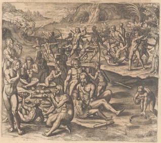
Scherer (H.). Iter S. Francisci Xaverii [...]Scherer (Heinrich) Iter S. Francisci Xaverii ex Europa in India, & Japoniam, world map on Mercator's projection, from Atlas Novus, showing California as an island, vignette shipping scenesSee Sold Price
WORLD MERCATOR showing mail routes to British colonies. RAPKIN/TALLIS 1851 mapTITLE/CONTENT OF MAP: 'The World on Mercator's Projection' Vignettes: Vesuvius; Gibraltar; London; Constantinople; Niagara; The Pyramids of Ghizeh; Pont Neuf, Paris. The steam ship routes to the colonSee Sold Price
SoldCortambert, Eugene 1874 Lot of 4 Maps. UK, World EuropeTwo of the British Isles, Europe Physical Map and World on Mercators Projection. Hand Coloured Lithograph Maps Published 1874, Paris for "Atlas de la Geographie de L'Europe" by Eugene Cortambert. PapeSee Sold Price
LATE 17TH C. FRENCH MAP OF THE NEW WORLD BY ALEXIS-HUBERT JAILLOT (1632-1712)Thomaston Place Auction Galleries4.4(393)See Sold PriceFeb 24, 2024
Jerusalem Map for British Soldiers in Palestine - WW2Levy Auction House4.3(11)See Sold PriceFeb 27, 2024
18 Booklets Collection - War Graves of Palestine - WWILevy Auction House4.3(11)See Sold PriceFeb 27, 2024
D'Oyly (Calcutta, India) - Government House from St. Andrew's LibraryTrillium Antique Prints & Rare Books4.5(32)See Sold PriceFeb 24, 2024
D'Oyly (Calcutta, India) - Procession of the CurruckpoojaTrillium Antique Prints & Rare Books4.5(32)See Sold PriceFeb 24, 2024
Arrowsmith & Lewis - Map of the World on Mercator's ProjectionTrillium Antique Prints & Rare Books4.5(32)See Sold PriceFeb 24, 2024
Carey, pub. 1796 - Map of GeorgiaTrillium Antique Prints & Rare Books4.5(32)See Sold PriceFeb 24, 2024
Carey, pub. 1796 - Map of The State of South CarolinaTrillium Antique Prints & Rare Books4.5(32)See Sold PriceFeb 24, 2024
Carey, pub. 1796 - Map of KentuckyTrillium Antique Prints & Rare Books4.5(32)See Sold PriceFeb 24, 2024
Carey, pub. 1796 - Map of the Tennassee State formerly part of North Carolina (Tennessee)Trillium Antique Prints & Rare Books4.5(32)See Sold PriceFeb 24, 2024
De Jode, Rare, pub. 1593 - Map of Africa (Africae Vera Forma, et Situs)Trillium Antique Prints & Rare Books4.5(32)See Sold PriceFeb 24, 2024
1834 Malte-Brun Map of the Caribbean -- West India IslandsJasper524.5(9.9k)See Sold PriceFeb 27, 2024
Blackie (Pub) 1882 Folio Map. Chinese Empire and JapanAlbion Auctions4.7(341)See Sold PriceMar 01, 2024
Blackie (Pub) 1882 Folio Map. West India Islands & Central AmericaAlbion Auctions4.7(341)See Sold PriceMar 01, 2024
Blackie (Pub) 1882 Folio Map. World on Mercators ProjectionAlbion Auctions4.7(341)See Sold PriceMar 01, 2024


![Scherer (H.). Iter S. Francisci Xaverii [...] (1 of 1)](https://p1.liveauctioneers.com/410/21399/7337489_1_x.jpg?height=282&quality=70)