ATLAS of ANTIENT GEOGRAPHY by SAMUEL BUTLER 1843John McInnis Auctioneers,LLC4.5(505)See Sold PriceFeb 24, 2024
18TH C. ANTIQUE MAP: FRENCH & INDIAN WAR, FRAMEDThomaston Place Auction Galleries4.4(393)See Sold PriceFeb 24, 2024
Rand McNally Railroad Map Cabinet w/ 21 Railroad MapsRail & Road Auctions4.6(165)See Sold PriceMar 08, 2024
Keith Haring - Ink on New York Map, Best Buddies, Inscribed, Signed, and DatedSapphire Auction Gallery4(67)See Sold PriceMar 02, 2024
LATE 17TH C. FRENCH MAP OF THE NEW WORLD BY ALEXIS-HUBERT JAILLOT (1632-1712)Thomaston Place Auction Galleries4.4(393)See Sold PriceFeb 24, 2024
Central Railroad of New Jersey Map of Sandy Hook Route-ca. 1903JM Hobby Supply and Railroad Artifact Auctions4.4(127)See Sold PriceFeb 24, 2024
Lot of Six Mixed Atlas Box Cars-HO Scale-New in BoxJM Hobby Supply and Railroad Artifact Auctions4.4(127)See Sold PriceFeb 25, 2024
Rand McNally/Santa Fe Railroad Map of Iowa-1912JM Hobby Supply and Railroad Artifact Auctions4.4(127)See Sold PriceFeb 24, 2024
NICOLAES VISSCHER (NETHERLANDS, 1618-1709) MAP OF THE NEW WORLDThomaston Place Auction Galleries4.4(393)See Sold PriceFeb 24, 2024
17TH C. WORLD MAP BY NICOLAES VISSCHER (NETHERLANDS, 1618-1709)Thomaston Place Auction Galleries4.4(393)See Sold PriceFeb 24, 2024
Lot of Six Mixed Atlas Cabooses-HO Scale-New in BoxJM Hobby Supply and Railroad Artifact Auctions4.4(127)See Sold PriceFeb 25, 2024
SoldWilkes, John 1802 Map. CumberlandCopper Engraved Map Published 1796-1828 London for "Encyclopaedia Londinensis, or universal dictionary of arts, sciences and literature" by John Wilkes et al. Paper Size: 10.5 x 8.5 inch (27 x 22cm) GSee Sold Price
SoldWilkes, John 1802 Map. DerbyshireCopper Engraved Map Published 1796-1828 London for "Encyclopaedia Londinensis, or universal dictionary of arts, sciences and literature" by John Wilkes et al. Paper Size: 10.5 x 8.5 inch (27 x 22cm) GSee Sold Price
SoldWilkes, John 1802 Fish Print. Very Fine Hand Colour"The Golden Tench, The Gudgeon, The Minnow" Hand Coloured Copper Plate Published 1796-1828 London for "Encyclopaedia Londinensis, or universal dictionary of arts, sciences and literature" by John WilkSee Sold Price
SoldWilkes, John 1797 Map. United StatesCopper Engraved Map Published 1796-1828 London for "Encyclopaedia Londinensis, or universal dictionary of arts, sciences and literature" by John Wilkes et al. Paper Size: 10.5 x 8.5 inch (27 x 22cm) GSee Sold Price
SoldWilkes, John 1811 Map. Middlesex LondonCopper Engraved Map Published 1796-1828 London for "Encyclopaedia Londinensis, or universal dictionary of arts, sciences and literature" by John Wilkes et al. Paper Size: 10.5 x 8.5 inch (27 x 22cm) VSee Sold Price
SoldWilkes, John 1798 Map. Ancient AfricaCopper Engraved Map Published 1796-1828 London for "Encyclopaedia Londinensis, or universal dictionary of arts, sciences and literature" by John Wilkes et al. Paper Size: 10.5 x 8.5 inch (27 x 22cm) GSee Sold Price
SoldWilkes, John 1796 Map. Modern AfricaCopper Engraved Map Published 1796-1828 London for "Encyclopaedia Londinensis, or universal dictionary of arts, sciences and literature" by John Wilkes et al. Paper Size: 10.5 x 8.5 inch (27 x 22cm) GSee Sold Price
SoldWilkes, John C1815 Map. Modern AsiaCopper Engraved Map Published 1796-1828 London for "Encyclopaedia Londinensis, or universal dictionary of arts, sciences and literature" by John Wilkes et al. Paper Size: 10.5 x 8.5 inch (27 x 22cm) TSee Sold Price
SoldWilkes, John 1811 Map. IrelandCopper Engraved Map Published 1796-1828 London for "Encyclopaedia Londinensis, or universal dictionary of arts, sciences and literature" by John Wilkes et al. Paper Size: 10.5 x 8.5 inch (27 x 22cm) GSee Sold Price
SoldWilkes, John C1800 Map. NorthumberlandCopper Engraved Map Published 1796-1828 London for "Encyclopaedia Londinensis, or universal dictionary of arts, sciences and literature" by John Wilkes et al. Paper Size: 10.5 x 8.5 inch (27 x 22cm) GSee Sold Price
SoldWilkes, John 1796 Map. South AmericaCopper Engraved Map Published 1796-1828 London for "Encyclopaedia Londinensis, or universal dictionary of arts, sciences and literature" by John Wilkes et al. Paper Size: 10.5 x 8.5 inch (27 x 22cm) GSee Sold Price
SoldWilkes, John C1815 Map. Ancient AsiaCopper Engraved Map Published 1796-1828 London for "Encyclopaedia Londinensis, or universal dictionary of arts, sciences and literature" by John Wilkes et al. Paper Size: 10.5 x 8.5 inch (27 x 22cm) TSee Sold Price
SoldWilkes, John 1817 Map. Monmouthshire, WalesCopper Engraved Map Published 1796-1828 London for "Encyclopaedia Londinensis, or universal dictionary of arts, sciences and literature" by John Wilkes et al. Paper Size: 10.5 x 8.5 inch (27 x 22cm) GSee Sold Price
SoldWilkes, John 1801 Map. BerkshireCopper Engraved Map Published 1796-1828 London for "Encyclopaedia Londinensis, or universal dictionary of arts, sciences and literature" by John Wilkes et al. Paper Size: 10.5 x 8.5 inch (27 x 22cm) GSee Sold Price
SoldWilkes, John 1803 Map. DurhamCopper Engraved Map Published 1796-1828 London for "Encyclopaedia Londinensis, or universal dictionary of arts, sciences and literature" by John Wilkes et al. Paper Size: 10.5 x 8.5 inch (27 x 22cm) GSee Sold Price
SoldWilkes, John C1800 Map. NottinghamshireCopper Engraved Map Published 1796-1828 London for "Encyclopaedia Londinensis, or universal dictionary of arts, sciences and literature" by John Wilkes et al. Paper Size: 10.5 x 8.5 inch (27 x 22cm) GSee Sold Price
SoldWilkes, John 1801 Map. BuckinghamshireCopper Engraved Map Published 1796-1828 London for "Encyclopaedia Londinensis, or universal dictionary of arts, sciences and literature" by John Wilkes et al. Paper Size: 10.5 x 8.5 inch (27 x 22cm) GSee Sold Price
Wilkes, John 1803 Map. DenmarkCopper Engraved Map Published 1796-1828 London for "Encyclopaedia Londinensis, or universal dictionary of arts, sciences and literature" by John Wilkes et al. Paper Size: 10.5 x 8.5 inch (27 x 22cm) GSee Sold Price
SoldWilkes, John 1804 Antique Map of Essex, UKCopper Engraved Map Published 1796-1828 London for "Encyclopaedia Londinensis, or universal dictionary of arts, sciences and literature" by John Wilkes et al. Paper Size: 10.5 x 8.5 inch (27 x 22cm) GSee Sold Price
Sold2 Antique maps2 Antique maps- John Wilkes- North America- engraved map wiht hand-coloring, 1796, engraved by Neele, fair condition with paper toning and staining throughout; and Cook/Hogg- Sketch of Nootka Sound, ASee Sold Price
Sold[Map]. John Speed. Cumberland and the Ancient Citie Car[Map]. John Speed. Cumberland and the Ancient Citie Carlile Described with Many MemSee Sold Price
Sold17th Century John Speed County Map of CumberlandCUMBERLAND AND THE ANCIENT CITIE CARLISLE DESCRIBED WITH MANY MEMORABLE AN/TIQUITIES THEREIN FOUND OBSERVED (London: Sudbury & Humble, 1610), hand-colored copperplate engraving "Performed by John SpeeSee Sold Price
SoldGreenwood (C & J) Cumberland & WestmorlandGreenwood (Christopher & John) Map of the County of Cumberland, from and Actual Survey; Map of the County of Westmorland ...,with vignette views of Carlisle Cathedral, and view of Appleby, resSee Sold Price
SoldJohn Speede (1552-1629) British. "Cumberland", Map,John Speede (1552-1629) British. "Cumberland", Map, Unframed, 15" x 19.75".See Sold Price
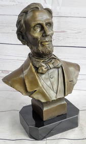
Large US President Abraham Lincoln Bronze Bust StatueWeatherham Estate Treasures3.9(159)See Sold PriceMar 07, 2024
Portfolio of 15 County Maps by Robert Morden (English 1650-1703)Nadeau's Auction Gallery4.7(409)See Sold PriceFeb 24, 2024
[THEATRE]. BOOTH, Edwin (1833-1893). CDV...Potter & Potter Auctions4.6(545)See Sold PriceMar 07, 2024
[THEATRE]. MITCHELL, Maggie (1832-1918). Po...Potter & Potter Auctions4.6(545)See Sold PriceMar 07, 2024
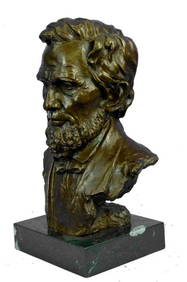
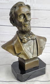
Abraham Lincoln Bronze Bust Sculpture On Marble Base - Signed Original - 10lbsWeatherham Estate Treasures3.9(159)See Sold PriceMar 14, 2024
NATIONAL TREASURE: BOOK OF SECRETS (2007) - Production-Made John Wilkes Booth (Christian Camargo) DiPropstore4.2(6)See Sold PriceMar 12, 2024
Bewick (Thomas).- Wallis (Richard) The Happy Village. A Poem, first edition, South Shields, JohnForum Auctions4.3(53)See Sold PriceFeb 29, 2024
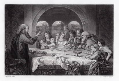
1867 Sir John Gilbert The Christiana at the House of Gaius engraving signedKCM Galleries4.7(164)See Sold PriceFeb 25, 2024
1800s WILLIAM ETTY Engraving Music on the Balcony SIGNED FramedKCM Galleries4.7(164)See Sold PriceFeb 25, 2024
Rees & Macpherson 1820 Lot of 6 Ancient Geography MapsAlbion Auctions4.6(341)See Sold PriceMar 01, 2024
Guthrie, William 1812 Antique Map. Spain and PortugalAlbion Auctions4.6(341)See Sold PriceMar 01, 2024
alan closter john cumberland beckett BAS signed 1969 topps rookie stars autograpGolden Air Auctions4.4(265)See Sold PriceFeb 28, 2024
John Senex Map of Louisiana & Mississippi RiverWillow Auction House4.5(289)See Sold PriceMar 14, 2024


![[Map]. John Speed. Cumberland and the Ancient Citie Car (1 of 1)](https://p1.liveauctioneers.com/906/21743/7489556_1_x.jpg?height=282&quality=70)


![[THEATRE]. BOOTH, Edwin (1833-1893). CDV... (1 of 1)](https://p1.liveauctioneers.com/928/318880/171361242_1_x.jpg?height=282&quality=70&version=1707501302)
![[THEATRE]. MITCHELL, Maggie (1832-1918). Po... (1 of 1)](https://p1.liveauctioneers.com/928/318880/171361246_1_x.jpg?height=282&quality=70&version=1707501302)