ATLAS of ANTIENT GEOGRAPHY by SAMUEL BUTLER 1843John McInnis Auctioneers,LLC4.6(504)See Sold PriceFeb 24, 2024
18TH C. ANTIQUE MAP: FRENCH & INDIAN WAR, FRAMEDThomaston Place Auction Galleries4.4(389)See Sold PriceFeb 24, 2024
Rand McNally Railroad Map Cabinet w/ 21 Railroad MapsRail & Road Auctions4.6(165)See Sold PriceMar 08, 2024
Keith Haring - Ink on New York Map, Best Buddies, Inscribed, Signed, and DatedSapphire Auction Gallery4.1(67)See Sold PriceMar 02, 2024
LATE 17TH C. FRENCH MAP OF THE NEW WORLD BY ALEXIS-HUBERT JAILLOT (1632-1712)Thomaston Place Auction Galleries4.4(389)See Sold PriceFeb 24, 2024
Central Railroad of New Jersey Map of Sandy Hook Route-ca. 1903JM Hobby Supply and Railroad Artifact Auctions4.4(126)See Sold PriceFeb 24, 2024
Lot of Six Mixed Atlas Box Cars-HO Scale-New in BoxJM Hobby Supply and Railroad Artifact Auctions4.4(126)See Sold PriceFeb 25, 2024
Rand McNally/Santa Fe Railroad Map of Iowa-1912JM Hobby Supply and Railroad Artifact Auctions4.4(126)See Sold PriceFeb 24, 2024
NICOLAES VISSCHER (NETHERLANDS, 1618-1709) MAP OF THE NEW WORLDThomaston Place Auction Galleries4.4(389)See Sold PriceFeb 24, 2024
17TH C. WORLD MAP BY NICOLAES VISSCHER (NETHERLANDS, 1618-1709)Thomaston Place Auction Galleries4.4(389)See Sold PriceFeb 24, 2024
Lot of Six Mixed Atlas Cabooses-HO Scale-New in BoxJM Hobby Supply and Railroad Artifact Auctions4.4(126)See Sold PriceFeb 25, 2024
SoldWilkes, John 1817 Map. Monmouthshire, WalesCopper Engraved Map Published 1796-1828 London for "Encyclopaedia Londinensis, or universal dictionary of arts, sciences and literature" by John Wilkes et al. Paper Size: 10.5 x 8.5 inch (27 x 22cm) GSee Sold Price
SoldBarber (John Thomas) A Tour through South Wales anBarber (John Thomas) A Tour through South Wales and Monmouthshire,first edition, folding engraved map coloured by hand, 20 aquatint plates after the author, printed in sepia, slightly offset,See Sold Price
Sold5 British county maps w/ color OL. Lon: Cary, 179[British Counties]. 5 engraved maps of British counties, from Lon: John Cary, 1793. Each approx. 10 7/8 x 8 3/4 in. Includes Derbyshire, Monmouthshire, Westmoreland, North Wales, and Cumberland. ColorSee Sold Price
England by John Thomson. England and Wales. Coach roadsReserve Reduced! TITLE/CONTENT OF MAP: 'England' DATE PRINTED: 1817 IMAGE SIZE: Approx 63.5 x 53.0cm, 25 x 20.75 inches (Large); Please note that this is a folding map. TYPE: Antique early 19th centurSee Sold Price
"England" by John Thomson. England and Wales. CoachTITLE/CONTENT OF MAP: 'England' DATE PRINTED: 1817 IMAGE SIZE: Approx 63.5 x 53.0cm, 25 x 20.75 inches (Large); Please note that this is a folding map. TYPE: Antique early 19th century atlas map withSee Sold Price
Australia.- Oxley (John) Journals of Two ExpeditionsAustralia.- Oxley (John) Journals of Two Expeditions into the Interior of New South Wales...1817-18, bound in 2 vol. with maps and tables in separate volume, first edition, [one of 500 copies], text wSee Sold Price
England by John Thomson. England and Wales. Coach roadsTITLE/CONTENT OF MAP: 'England' This map is folding hence the centrefold line may show on the image below DATE PRINTED: 1817 IMAGE SIZE: Approx 63.5 x 53.0cm, 25 x 20.75 inches (Large); Please note thSee Sold Price
SoldWilkes, John 1797 Map. United StatesCopper Engraved Map Published 1796-1828 London for "Encyclopaedia Londinensis, or universal dictionary of arts, sciences and literature" by John Wilkes et al. Paper Size: 10.5 x 8.5 inch (27 x 22cm) GSee Sold Price
SoldWilkes, John 1811 Map. Middlesex LondonCopper Engraved Map Published 1796-1828 London for "Encyclopaedia Londinensis, or universal dictionary of arts, sciences and literature" by John Wilkes et al. Paper Size: 10.5 x 8.5 inch (27 x 22cm) VSee Sold Price
SoldWilkes, John 1798 Map. Ancient AfricaCopper Engraved Map Published 1796-1828 London for "Encyclopaedia Londinensis, or universal dictionary of arts, sciences and literature" by John Wilkes et al. Paper Size: 10.5 x 8.5 inch (27 x 22cm) GSee Sold Price
SoldWilkes, John 1796 Map. Modern AfricaCopper Engraved Map Published 1796-1828 London for "Encyclopaedia Londinensis, or universal dictionary of arts, sciences and literature" by John Wilkes et al. Paper Size: 10.5 x 8.5 inch (27 x 22cm) GSee Sold Price
SoldWilkes, John C1815 Map. Modern AsiaCopper Engraved Map Published 1796-1828 London for "Encyclopaedia Londinensis, or universal dictionary of arts, sciences and literature" by John Wilkes et al. Paper Size: 10.5 x 8.5 inch (27 x 22cm) TSee Sold Price
SoldWilkes, John 1811 Map. IrelandCopper Engraved Map Published 1796-1828 London for "Encyclopaedia Londinensis, or universal dictionary of arts, sciences and literature" by John Wilkes et al. Paper Size: 10.5 x 8.5 inch (27 x 22cm) GSee Sold Price
SoldWilkes, John C1800 Map. NorthumberlandCopper Engraved Map Published 1796-1828 London for "Encyclopaedia Londinensis, or universal dictionary of arts, sciences and literature" by John Wilkes et al. Paper Size: 10.5 x 8.5 inch (27 x 22cm) GSee Sold Price
SoldWilkes, John 1802 Map. CumberlandCopper Engraved Map Published 1796-1828 London for "Encyclopaedia Londinensis, or universal dictionary of arts, sciences and literature" by John Wilkes et al. Paper Size: 10.5 x 8.5 inch (27 x 22cm) GSee Sold Price
SoldWilkes, John 1796 Map. South AmericaCopper Engraved Map Published 1796-1828 London for "Encyclopaedia Londinensis, or universal dictionary of arts, sciences and literature" by John Wilkes et al. Paper Size: 10.5 x 8.5 inch (27 x 22cm) GSee Sold Price
SoldWilkes, John C1815 Map. Ancient AsiaCopper Engraved Map Published 1796-1828 London for "Encyclopaedia Londinensis, or universal dictionary of arts, sciences and literature" by John Wilkes et al. Paper Size: 10.5 x 8.5 inch (27 x 22cm) TSee Sold Price
SoldWilkes, John 1801 Map. BerkshireCopper Engraved Map Published 1796-1828 London for "Encyclopaedia Londinensis, or universal dictionary of arts, sciences and literature" by John Wilkes et al. Paper Size: 10.5 x 8.5 inch (27 x 22cm) GSee Sold Price
SoldWilkes, John 1803 Map. DurhamCopper Engraved Map Published 1796-1828 London for "Encyclopaedia Londinensis, or universal dictionary of arts, sciences and literature" by John Wilkes et al. Paper Size: 10.5 x 8.5 inch (27 x 22cm) GSee Sold Price
SoldWilkes, John 1802 Map. DerbyshireCopper Engraved Map Published 1796-1828 London for "Encyclopaedia Londinensis, or universal dictionary of arts, sciences and literature" by John Wilkes et al. Paper Size: 10.5 x 8.5 inch (27 x 22cm) GSee Sold Price
SoldWilkes, John C1800 Map. NottinghamshireCopper Engraved Map Published 1796-1828 London for "Encyclopaedia Londinensis, or universal dictionary of arts, sciences and literature" by John Wilkes et al. Paper Size: 10.5 x 8.5 inch (27 x 22cm) GSee Sold Price
SoldWilkes, John 1801 Map. BuckinghamshireCopper Engraved Map Published 1796-1828 London for "Encyclopaedia Londinensis, or universal dictionary of arts, sciences and literature" by John Wilkes et al. Paper Size: 10.5 x 8.5 inch (27 x 22cm) GSee Sold Price
Wilkes, John 1803 Map. DenmarkCopper Engraved Map Published 1796-1828 London for "Encyclopaedia Londinensis, or universal dictionary of arts, sciences and literature" by John Wilkes et al. Paper Size: 10.5 x 8.5 inch (27 x 22cm) GSee Sold Price
1817 Southern Provinces of the United StatesThis is a scarce first edition of John Thomson’s 1817 map of the southeastern part of the United States, with outline coloring. The map covers from the Mississippi River eastward to the AtlantiSee Sold Price
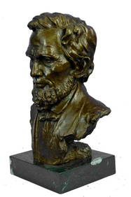
Large US President Abraham Lincoln Bronze Bust StatueWeatherham Estate Treasures3.9(157)See Sold PriceMar 07, 2024
De Passe. Portraits. To include: Charles I (as Prince of Wales), John Foxe, Elizabeth I, Elizabeth ITremont Auctions4.6(294)See Sold PriceFeb 25, 2024
Portfolio of 15 County Maps by Robert Morden (English 1650-1703)Nadeau's Auction Gallery4.7(405)See Sold PriceFeb 24, 2024
[THEATRE]. BOOTH, Edwin (1833-1893). CDV...Potter & Potter Auctions4.6(544)See Sold PriceMar 07, 2024
[THEATRE]. MITCHELL, Maggie (1832-1918). Po...Potter & Potter Auctions4.6(544)See Sold PriceMar 07, 2024
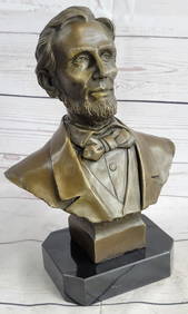
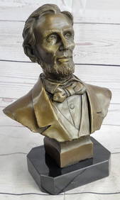
Abraham Lincoln Bronze Bust Sculpture On Marble Base - Signed Original - 10lbsWeatherham Estate Treasures3.9(157)See Sold PriceMar 14, 2024
[ABOLITIONISTS]. JAY, John II (1817-1894). ALS ("John Jay"), to J. Dewitt Miller. Katonah, [NY],Freeman's | Hindman4.4(1.6k)See Sold PriceFeb 27, 2024
NATIONAL TREASURE: BOOK OF SECRETS (2007) - Production-Made John Wilkes Booth (Christian Camargo) DiPropstore4.2(6)See Sold PriceMar 12, 2024
West Indies Islands. Guadaloupe. | Mariegalante &C. | Antigua.Jasper524.5(9.8k)See Sold PriceFeb 27, 2024
Pre-colonial Africa. Mountains of Kong/Moon. Caravan routes. THOMSON 1817 mapJasper524.5(9.8k)See Sold PriceFeb 28, 2024
Late 18th century map of England and Wales sampler and two printsFellows4.3(159)See Sold PriceMar 05, 2024
Antique Map - Views on the coast of Asia. J. Webber del. Engraved after J. Webber and W. Bligh.Proverde Auctions4.3(3)See Sold PriceFeb 28, 2024
John Senex Map of Louisiana & Mississippi RiverWillow Auction House4.5(284)See Sold PriceMar 14, 2024


![[THEATRE]. BOOTH, Edwin (1833-1893). CDV... (1 of 1)](https://p1.liveauctioneers.com/928/318880/171361242_1_x.jpg?height=282&quality=70&version=1707501302)
![[THEATRE]. MITCHELL, Maggie (1832-1918). Po... (1 of 1)](https://p1.liveauctioneers.com/928/318880/171361246_1_x.jpg?height=282&quality=70&version=1707501302)
![[ABOLITIONISTS]. JAY, John II (1817-1894). ALS ("John Jay"), to J. Dewitt Miller. Katonah, [NY], (1 of 2)](https://p1.liveauctioneers.com/197/319238/171468084_1_x.jpg?height=282&quality=70&version=1707520367)