ATLAS of ANTIENT GEOGRAPHY by SAMUEL BUTLER 1843John McInnis Auctioneers,LLC4.6(502)See Sold PriceFeb 24, 2024
18TH C. ANTIQUE MAP: FRENCH & INDIAN WAR, FRAMEDThomaston Place Auction Galleries4.4(386)See Sold PriceFeb 24, 2024
Rand McNally Railroad Map Cabinet w/ 21 Railroad MapsRail & Road Auctions4.6(165)See Sold PriceMar 08, 2024
Keith Haring - Ink on New York Map, Best Buddies, Inscribed, Signed, and DatedSapphire Auction Gallery4(67)See Sold PriceMar 02, 2024
LATE 17TH C. FRENCH MAP OF THE NEW WORLD BY ALEXIS-HUBERT JAILLOT (1632-1712)Thomaston Place Auction Galleries4.4(386)See Sold PriceFeb 24, 2024
Central Railroad of New Jersey Map of Sandy Hook Route-ca. 1903JM Hobby Supply and Railroad Artifact Auctions4.4(126)See Sold PriceFeb 24, 2024
Lot of Six Mixed Atlas Box Cars-HO Scale-New in BoxJM Hobby Supply and Railroad Artifact Auctions4.4(126)See Sold PriceFeb 25, 2024
Rand McNally/Santa Fe Railroad Map of Iowa-1912JM Hobby Supply and Railroad Artifact Auctions4.4(126)See Sold PriceFeb 24, 2024
NICOLAES VISSCHER (NETHERLANDS, 1618-1709) MAP OF THE NEW WORLDThomaston Place Auction Galleries4.4(386)See Sold PriceFeb 24, 2024
17TH C. WORLD MAP BY NICOLAES VISSCHER (NETHERLANDS, 1618-1709)Thomaston Place Auction Galleries4.4(386)See Sold PriceFeb 24, 2024
Lot of Six Mixed Atlas Cabooses-HO Scale-New in BoxJM Hobby Supply and Railroad Artifact Auctions4.4(126)See Sold PriceFeb 25, 2024
SoldWest Indies.- A good group of 22 maps and charts of theWest Indies.- A good group of 22 maps and charts of the Islands of Antigua, Dominica, St. Vincent, Grenada, Trinidad and Tobago, including Thomson's 'West India Islands. St. Vincent [and] Barbadoes' aSee Sold Price
Sold[United States/West Indies Maps] Three good maps[United States/West Indies Maps] Three good maps including: @A New and Accurate Chart of the West Indies with the Adjacent Coasts of North and South America@, by Emanuel Bowen, London, c. 1744, ornameSee Sold Price
SDUK A good group of maps of AmericaSociety For The Diffusion Of Useful Knowledge (The) A group of maps of America,including an index map and 11 of 13 sheets of North America, others of the West Indies, Central and South AmericaSee Sold Price
Sold"The New Indians" - Book by Stan SteinerDATE: 1986 DESCRIPTION: "The New Indians" hardback book by Stan Steiner with original dust jacket. Very good condition. Contains maps, charts, 22 halftones, documents, B&W photos, 348 pages. Book dealSee Sold Price
West Indies by John Dower. Caribbean Antilles 1845 old antique map plan chartTITLE/CONTENT OF MAP: 'West Indies' DATE PRINTED: 1845 IMAGE SIZE: Approx 22.0 x 27.0cm, 8.75 x 10.75 inches (Medium) TYPE: Antique map with original hand colouring CONDITION: Fair: Repaired tear in lSee Sold Price
Sold(Maps and Charts, West Indies), Delarochette, L. S(Maps and Charts, West Indies), Delarochette, L. S. d'Arcy, A General Chart of the West India Islands..., London: William Faden, September 22, 1796, with hand-colored borders, double page folio, matteSee Sold Price
Martinique. West Indies. The Lesser Antilles 1885 old antique map plan chartTITLE/CONTENT OF MAP: 'Martinique' DATE PRINTED: 1885 IMAGE SIZE: Approx 15.5 x 11.0cm, 6 x 4.5 inches (Small) TYPE: Antique wood-engraved map; Scale 1:430,000 CONDITION: Good; suitable for framing. PSee Sold Price
Martinique. West Indies. The Lesser Antilles 1885 old antique map plan chartTITLE/CONTENT OF MAP: 'Martinique' DATE PRINTED: 1885 IMAGE SIZE: Approx 15.5 x 11.0cm, 6 x 4.5 inches (Small) TYPE: Antique wood-engraved map; Scale 1:430,000 CONDITION: Good; suitable for framing. PSee Sold Price
BARBADOS. Vintage map. West Indies Caribbean 1923 old vintage plan chartTITLE/CONTENT OF MAP: 'Barbados' DATE PRINTED: 1923 IMAGE SIZE: Approx 17.0 x 14.0cm, 6.75 x 5.5 inches (Medium); Please note that this is a folding map. TYPE: Vintage colour map CONDITION: Good; suitSee Sold Price
JAMAICA. Vintage map. West Indies. Caribbean 1927 old vintage plan chartTITLE/CONTENT OF MAP: 'Jamaica' DATE PRINTED: 1927 IMAGE SIZE: Approx 11.5 x 17.5cm, 4.5 x 7 inches (Small); Please note that this is a folding map. TYPE: Vintage colour map CONDITION: Good; suitableSee Sold Price
BARBADOS. Vintage map. West Indies Caribbean 1923 old vintage plan chartTITLE/CONTENT OF MAP: 'Barbados' DATE PRINTED: 1923 IMAGE SIZE: Approx 17.0 x 14.0cm, 6.75 x 5.5 inches (Medium); Please note that this is a folding map. TYPE: Vintage colour map CONDITION: Good; suitSee Sold Price
SoldGroup of 14 engraved maps, - most depicting Islands,most depicting Islands, including: Dominica in the West Indies, Carta Del'Isola Grenada, the Bahama Islands, Isle of St Christophe and also a Chart of Cook's Strait in New Zealand, all with contemporaSee Sold Price
Sold(4 re: West Indies) The History, Civil and Commerc(4 re: West Indies) The History, Civil and Commercial of the British Colonies in the West Indies in Two Volumes (Volume II Only) Luke White, Dublin, 1793. Very Good. Folding Charts. 1st Dublin EditionSee Sold Price
Sold(WEST INDIES.) Group of 20 engraved maps of th(WEST INDIES.) Group of 20 engraved maps of the West Indies or portions thereof, extracted from various British magazines, generally small sizes, but several larger, generally ample margins; conditionSee Sold Price
SoldWest Indies.- - A small mixed group of maps,comprising A New and Accurate Map of the Island of Antigua or Antego, by Emanuel Bowen; Map of the Island of Tobago, by Bryan Edwards; The Island of St Christophers alias St. Kits, by Herman Moll; PiaSee Sold Price
West Indies.- - A small mixed group of maps,comprising A New and Accurate Map of the Island of Antigua or Antego, by Emanuel Bowen; Map of the Island of Tobago, by Bryan Edwards; The Island of St Christophers alias St. Kits, by Herman Moll; PiaSee Sold Price
West Indies.- - A small mixed group of maps,comprising Jamaica from the Latest Surveys, by Thomas Jefferys; A New and Accurate Map of the Island of Antiguaor Antego, by Emanuel Bowen; Map of the Island of Tobago, by Bryan Edwards; The Island ofSee Sold Price
Sold(WEST INDIES.) Group of approximately 30 engra(WEST INDIES.) Group of approximately 30 engraved maps of the West Indies or parts thereof, on various size sheets small to large, variable margins; a few with color; condition varies greatly, the betSee Sold Price
A.J. JohnsonArtist: A.J. Johnson, West Indies Map, 1864 A.J. Johnson Size: 18 3/8" x 22" West Indies Map, 1864See Sold Price
SoldWest Indies.- Various A group of 18th Century mapsWest Indies.- Various A group of 18th Century maps depicting Mexico, the Caribbean and the West Atlantic Coast,Comprising 'Les Isles de l'Amerique Connue Sous le Nom d'Antilles' by Nicolas DeSee Sold Price
SoldMap, Chart of the West Indies and Spanish DominioMap, Chart of the West Indies and Spanish Dominions in North America, By A. Arrowsmith, 1803, 56"L x 48"hSee Sold Price
SoldMap Showing the 4 Voyages of Christopher ColumbusMap: Chart of the West Indies With the Adjacent Coast of South America, Showing The Tracks Of Don Christopher Columbus Size: Folio – 11.00 H x 15.90 W Inches Publisher: George P. Putnam 1849 New YorSee Sold Price
Sold1775 THOMAS JEFFERYS WEST INDIES MAPJEFFERYS, Thomas, (1719-1771): An Index Map to the Following Sixteen Sheets; being a Compleat Chart of the West Indies map. London: Robert Sayer, 1775. Copper engraving, 14 1/2'' x 25'' ins., Hand colSee Sold Price
SoldThree Atlas Maps, West Indies and Sun ChartBritish, 18th/19th century, Thomas Kitchin Map of West Indies, engraving on paper, framed; British Islands of West Indies, with hand coloring, unframed; [Tableau Synoptique des Elements Du Systeme SolSee Sold Price
Carey, pub. 1796 - A Chart of the West IndiesTrillium Antique Prints & Rare Books4.5(30)See Sold PriceFeb 24, 2024
Map of Part of the West Indies, Etc., Showing the Exact Position Of The U.S. War Steamer SanJasper524.5(9.8k)See Sold PriceFeb 27, 2024
West Africa by Arrowsmith & Lewis 1812 old antique vintage map plan chartJasper524.5(9.8k)See Sold PriceFeb 28, 2024
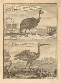
Pintado or Guinea-Hen. African Swan, or Gambian Stork. West African birds 1745Jasper524.5(9.8k)See Sold PriceFeb 28, 2024
West coast of Africa from Cape Blanco… Arguin bay, Mauritania. LABAT 1745 mapJasper524.5(9.8k)See Sold PriceFeb 28, 2024
West African fruit. Kola nut. Guava fruit. Kalabash Calabash tree 1745 printJasper524.5(9.8k)See Sold PriceFeb 28, 2024
North-west Africa. Morocco &c. Sahara desert. Unresolved borders. TIMES 1922 mapJasper524.5(9.8k)See Sold PriceFeb 28, 2024
Gulf of Guinea. Ghana Togo Benin Nigeria. ADMIRALTY sea chart 1928 (1954) mapJasper524.5(9.8k)See Sold PriceFeb 28, 2024
Colonial & French West Africa. Gold Coast Dahomey Upper Volta. TIMES 1922 mapJasper524.5(9.8k)See Sold PriceFeb 28, 2024
South Namibia coast. Walvis Bay-Orange River ADMIRALTY sea chart 1881 (1954) mapJasper524.5(9.8k)See Sold PriceFeb 28, 2024
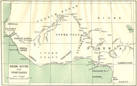
AFRICA. Niger River and Tributaries 1936 old vintage map plan chartJasper524.5(9.8k)See Sold PriceFeb 28, 2024
NAMIBIA. South West Africa protectorate. HARMSWORTH 1920 old antique map chartJasper524.5(9.8k)See Sold PriceFeb 28, 2024
Cooke, George 1801 Antique Map. West Indies CaribbeanAlbion Auctions4.6(336)See Sold PriceMar 01, 2024
Blackie (Pub) 1882 Folio Map. East Indies - Indian ArchipelagoAlbion Auctions4.6(336)See Sold PriceMar 01, 2024
Blackie (Pub) 1882 Folio Map. West India Islands & Central AmericaAlbion Auctions4.6(336)See Sold PriceMar 01, 2024


![[United States/West Indies Maps] Three good maps (1 of 3)](https://p1.liveauctioneers.com/268/2586/1120904_1_x.jpg?height=282&quality=70)