West Indies.- A good group of 22 maps and charts of the
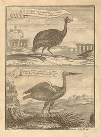
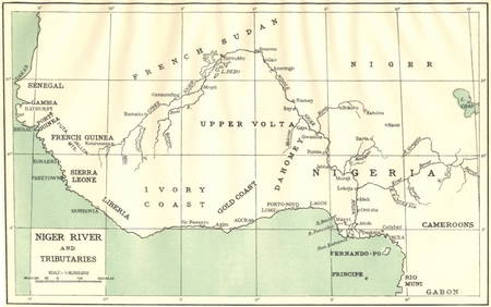
Group of 12 Sinclair Road MapsFeb 25, 2024Original Blur 'Good Song' PosterFeb 25, 2024Carey, pub. 1796 - A Chart of the West IndiesFeb 24, 2024Untitled. Gulf of Mexico, Western West IndiesFeb 27, 2024Map of Part of the West Indies, Etc., Showing the Exact Position Of The U.S. War Steamer SanFeb 27, 2024West India Islands, and Central America.Feb 27, 2024West IndiesFeb 27, 2024West Africa by Arrowsmith & Lewis 1812 old antique vintage map plan chartFeb 28, 2024Pintado or Guinea-Hen. African Swan, or Gambian Stork. West African birds 1745Feb 28, 2024West coast of Africa from Cape Blanco… Arguin bay, Mauritania. LABAT 1745 mapFeb 28, 2024West African fruit. Kola nut. Guava fruit. Kalabash Calabash tree 1745 printFeb 28, 2024North-west Africa. Morocco &c. Sahara desert. Unresolved borders. TIMES 1922 mapFeb 28, 2024Gulf of Guinea. Ghana Togo Benin Nigeria. ADMIRALTY sea chart 1928 (1954) mapFeb 28, 2024Colonial & French West Africa. Gold Coast Dahomey Upper Volta. TIMES 1922 mapFeb 28, 2024South Namibia coast. Walvis Bay-Orange River ADMIRALTY sea chart 1881 (1954) mapFeb 28, 2024AFRICA. Niger River and Tributaries 1936 old vintage map plan chartFeb 28, 2024NAMIBIA. South West Africa protectorate. HARMSWORTH 1920 old antique map chartFeb 28, 2024AFRICA. West 1911 old antique vintage map plan chartFeb 28, 2024Cooke, George 1801 Antique Map. West Indies CaribbeanMar 01, 2024Blackie (Pub) 1882 Folio Map. East Indies - Indian ArchipelagoMar 01, 2024Blackie (Pub) 1882 Folio Map. West India Islands & Central AmericaMar 01, 2024MAP, Alaska, VancouverMar 12, 2024MAP, Asia, WitMar 12, 2024MAP, East Indies, DudleyMar 12, 2024 


![[United States/West Indies Maps] Three good maps (1 of 3)](https://p1.liveauctioneers.com/268/2586/1120904_1_x.jpg?height=282&quality=70)