ATLAS of ANTIENT GEOGRAPHY by SAMUEL BUTLER 1843John McInnis Auctioneers,LLC4.5(505)See Sold PriceFeb 24, 2024
18TH C. ANTIQUE MAP: FRENCH & INDIAN WAR, FRAMEDThomaston Place Auction Galleries4.4(393)See Sold PriceFeb 24, 2024
Rand McNally Railroad Map Cabinet w/ 21 Railroad MapsRail & Road Auctions4.6(165)See Sold PriceMar 08, 2024
Keith Haring - Ink on New York Map, Best Buddies, Inscribed, Signed, and DatedSapphire Auction Gallery4(67)See Sold PriceMar 02, 2024
LATE 17TH C. FRENCH MAP OF THE NEW WORLD BY ALEXIS-HUBERT JAILLOT (1632-1712)Thomaston Place Auction Galleries4.4(393)See Sold PriceFeb 24, 2024
Central Railroad of New Jersey Map of Sandy Hook Route-ca. 1903JM Hobby Supply and Railroad Artifact Auctions4.4(127)See Sold PriceFeb 24, 2024
Lot of Six Mixed Atlas Box Cars-HO Scale-New in BoxJM Hobby Supply and Railroad Artifact Auctions4.4(127)See Sold PriceFeb 25, 2024
Rand McNally/Santa Fe Railroad Map of Iowa-1912JM Hobby Supply and Railroad Artifact Auctions4.4(127)See Sold PriceFeb 24, 2024
NICOLAES VISSCHER (NETHERLANDS, 1618-1709) MAP OF THE NEW WORLDThomaston Place Auction Galleries4.4(393)See Sold PriceFeb 24, 2024
17TH C. WORLD MAP BY NICOLAES VISSCHER (NETHERLANDS, 1618-1709)Thomaston Place Auction Galleries4.4(393)See Sold PriceFeb 24, 2024
Lot of Six Mixed Atlas Cabooses-HO Scale-New in BoxJM Hobby Supply and Railroad Artifact Auctions4.4(127)See Sold PriceFeb 25, 2024
SoldTwo 18th C Maps, G. M. CassiniBy Italian engraver, Giovanni Maria Cassini (1745-1824). 1. Map of Part of the Kingdom of Sardinia and Part of the Kingdom of Genoa: Rome, possibly c.1791. Copper engraved print, hand coloured. The thSee Sold Price
Sold"Carte des Provinces Unies..." G.M. Cassini, map"Carte des Provinces Unies..." G.M. Cassini, map, 18th Century, "Carte des Provinces Unies des Pays Bas", Royal Academy of Sciences, Paris, 1702, with some hand coloring, 19.5" x 25" (sight), framed uSee Sold Price
SoldTwo 18th C Leather Bound BooksAn epistolary discussion upon religion, between G. W. a Protestant of the Church of England, and M. J. B. B. a French Roman Catholic Sold by T. Cadel and W. Davies, in the Strand; J. Boosey, Old BroadSee Sold Price
SoldTwo 18th C. Maps & Two 18th C. EngravingsLot consists of three 18th century engravings--1st item: Mid 18th century map titled "A New Map of Carolina by Robert Morden"; page taken from a book or publication "A Description of Carolina"; map siSee Sold Price
Sold6 FRAMED ITEMS, TWO 18TH C. MAPS, 12 1/4" X 161/4" OVERALL, WATERCOLOR SIGNED JOAN BRUMLEY, 17" X 21" OVERALL, EARLY ENGRAVING 14 1/4" 19" OVERALL, 2 HUNGARIAN FOLK DRAWERS, 11 1/2" X 14 1/2" OVERALL, BARTOK ESTATESee Sold Price
SoldTWO 18TH C. MAPS *NEW ENGLAND, NEW YORK, NEW JERSTWO 18TH C. MAPS *NEW ENGLAND, NEW YORK, NEW JERSEY, & PENSILVANIA (SIC) BY H. MOLL, GEOGRAPHER* AND NORTH AMERICA SIGNED NAME UNCERTAIN; 14 1/2 IN X 9 1/4 IN & NA IS 10 1/4 IN X 8 INSee Sold Price
SoldTWO 18TH C. VT MAPS, J. SCOTT & J. WHITELAW.James Whitelaw 1794 engraved map of VT in an antique frame 21” x 17” overall, Joseph Scott 1795 State of Vermont in an antique frame 17” x 15” overall.See Sold Price
SoldTwo Framed 18th c. Maps Maryland - DelawareTWO framed 18th century maps of Maryland & Delaware 1) Maryland and Delaware together: "J. Denison" c. 1796 at 8" high by 10" wide inside matting.2) "State of Maryland by Samuel Lewis" measuring 11.5"See Sold Price
SoldTwo 18th C. Framed Asian MapsFrom "A Geography of the World," London 1768. One depicting a map of China, the other depicting a map of Asia. Framed behind glass, 14.5" H x 15.5" W.See Sold Price
2 18th C. European Maps, Bowen & BuchhandlungTwo (2) 18th C. European Maps, including Bowen & Buchhandlung. 1st item: "Plan der Action bey Sandershausen" Map, published by Raspischen Buchhandlung , Nuremberg, circa 1760. Copper plate engraving wSee Sold Price
Antiquarian Hand Colored Maps of Britain, (2pc)Two 18th C. hand colored maps, England: (1) Circa 1750 map of Staffordshire, T. KIchen. Detailed map with decorative cartouche, hand colored. Strong plate impression and color, framed under glass. MeaSee Sold Price
SoldTwo 18th C. Hand Colored Engraved Maps.From a Connecticut, CT estate. Dimensions: sheets - 17" high x 24.5" wide and 16.5" high x 25" wide. Condition: Not examined out of frames. Toned paper, trimmed margins, both with center fold creases,See Sold Price
18th C. Map & Two 18th C. EngravingsLot consists of three 18th century engravings--1st item: c. 1765 map of South America, pictorial cartouche lower left "A NEW & CORRECT MAP OF SOUTH AMERICA from the latest Improvements and regulated bSee Sold Price
SoldTwo maps, 18thc., "A New and Accurate Map of the PrTwo maps, 18thc., "A New and Accurate Map of the Present War in North America. 1797" hand colored 9"x13.75" and "Principal Seat of War, 1756" 8"x10".See Sold Price
SoldHERMAN MOLL HAND COLORED ENGRAVED MAPS 18TH C. TWOHERMAN MOLL, HAND COLORED ENGRAVED MAPS, 18TH C., TWO, GREAT BRITAIN, IRELAND, GALLOWAY:Under glass and matted in matched frames. Lyons Ltd., Antique Prints label. Visible image size 7 3/4" x 10 1/4".See Sold Price
SoldThree early engraved European maps, 18th c., twoThree early engraved European maps, 18th c., two depicting Bohemia, the other Silesiae, largest - 19'' x 22 1/2''.See Sold Price
TWO LATE 18TH C. RIGOBERT BONNE DOUBLE SIDED MAPSTwo Rigobert Bonne (French 1727-1794), double sided maps, late 1780s, etching on paper comprising one map of the Tierra del Fuego and South Atlantic Islands and one map of the Strait of Magellan and TSee Sold Price
SoldHector Guimard, Two door panels 'GM', c. 1900Hector Guimard, Two door panels 'GM', c. 1900, 89.5 x 28 cm. Made by Fonderie de St. Dizier, c. 1921. Cast iron.,See Sold Price
SoldSIX 19TH CEN. JOHNSON AND COLTON MAPS OF MISSOURIIncludes two 1869 G.W. & C.B. Colton maps of Missouri, 17.25 x 28.5 inches; Johnson's Missouri and Kansas, 1865, measures 18 x 26.25 inches. Another Johnson and Ward Missouri and Kansas, 18 x 26.25 inSee Sold Price
SoldG.C. Eimmart, 18th c. celestial mapG.C. Eimmart, 18th c. celestial map, Georg Christoph Eimmart (German, 1638-1705), "Planetsphaerium Caeleste", c. 1700, a celestial planisphere featuring the constellations of the northern and southernSee Sold Price
Sold17th and 18th C. Maps of Florida and EnglandTwo 17th & 18th century maps. Item 1: Hand-colored and engraved map of West Florida, dated 1772. Titled "A Map of Part of West Florida, from Pensacola to the Mouth of the Iberville River, with a ViewSee Sold Price
SoldTWO (18th c) PEWTER BOWLSEach stamped with makers marks and stamped with cartouche. (1) is stamped M.B. on rim. 13 inches.See Sold Price
SoldTwo 18th C Leather Bound Books, by Thomas NugentTwo 18th C Leather Bound Books, by Thomas Nugent The Spirit of Laws in Two Volumes translated from the French of M. De Secondat, Baron De Montesquieu. The Eleventh Edition as noted. Published by S. CrSee Sold Price
EARLY 18TH C. DUTCH CHART OF PACIFIC OCEAN BY FREDERIK DE WIT (1629-1706) WITH CALIFORNIA AS ANThomaston Place Auction Galleries4.4(393)See Sold PriceFeb 24, 2024
EARLY 18TH C. MAP OF ITALY, FRAMEDThomaston Place Auction Galleries4.4(393)See Sold PriceFeb 24, 2024
18TH C. ANTIQUE MAP: FRENCH & INDIAN WAR, FRAMEDThomaston Place Auction Galleries4.4(393)See Sold PriceFeb 24, 2024
Two (2) Antique 18th C. Copper Engraved Framed Maps - America & EuropeMagnusson Art Group4.5(53)See Sold PriceMar 14, 2024
1778 PHAEDRUS FABULARUM AESOPIARUM ANCIENT ARMORED VELLUM BINDINGNY Elizabeth 4.2(86)See Sold PriceMar 03, 2024
Seven boxed 1:72 scale limited edition die-cast models of WWII Junkers bombers and aircraft by C...Bonhams4.1(320)See Sold PriceMar 01, 2024
14k Two-tone Polished & D/C Fancy Post Earrings - 47 mmGolden Air Auctions4.4(265)See Sold PriceFeb 27, 2024
TWO ANTIQUE JEWISH NATIONAL FUND CHARITY BOXES. The first one made in Berlin c. 1920J. Greenstein & Co., Inc.4.2(55)See Sold PriceApr 16, 2024
14K Two-tone Polished & D/C Butterfly Bracelet - 7 in.Golden Air Auctions4.4(265)See Sold PriceFeb 24, 2024
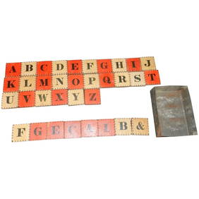
Antique Civil War Era Alphabet Block Set with Two Color Letter and Number BlocksJasper524.5(9.9k)See Sold PriceMar 07, 2024
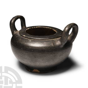
Two Jemez Pueblo redware pottery vesselsJohn Moran Auctioneers, Inc.4.7(461)See Sold PriceMar 12, 2024
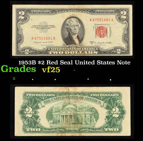
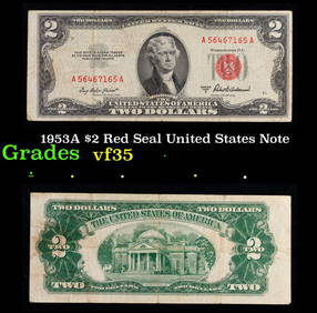
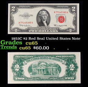
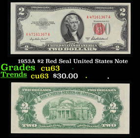
1953A $2 Red Seal United States Note Grades Select CUKey Date Coins4.4(1.4k)See Sold PriceFeb 28, 2024
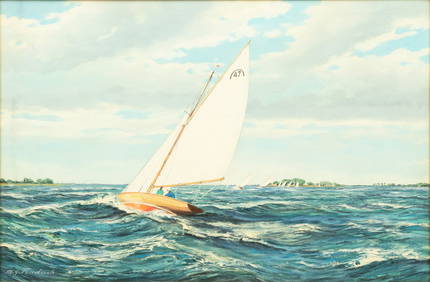
M. G. Friedrich (German/American (20th C.)) Oil on Canvas Ca. 1950, "Sailing Off Cape Cod", H 24" WDuMouchelles4.6(830)See Sold PriceMar 15, 2024