Vintage Ca. 1940's International Panel Delivery Truck Converted into Stationary Food Truck, WasSwisher Bros. Auction LLC4.4(255)See Sold PriceFeb 25, 2024
Martin Custom Acoustic Guitar 000 Body Style Rosewood with Hard CaseHess Fine Auctions4.5(210)See Sold PriceMar 02, 2024
1968 Gibson LG-0 Acoustic Dreadnought Parlor GuitarHess Fine Auctions4.5(210)See Sold PriceMar 02, 2024
Replica Robinson 1862 Sharps CarbineSchmidt's Antiques Inc. Since 19114.8(431)See Sold PriceMar 02, 2024
PAIR (18th c) OF FLINTLOCK DUELING PISTOLSJohn McInnis Auctioneers,LLC4.5(505)See Sold PriceFeb 24, 2024
PAIR T KETLAND of LONDON .60 CAL FLINTLOCK PISTOLSJohn McInnis Auctioneers,LLC4.5(505)See Sold PriceFeb 25, 2024
Gibson ES335 Semi Hollow Vintage Sunburst Electric Guitar with Certificate of Authenticity Hand MadeHess Fine Auctions4.5(210)See Sold PriceMar 02, 2024
WALT DISNEY WORLD - Figment Animatronic Character Skin from EPCOT's Journey Into ImaginationPropstore4.2(6)See Sold PriceMar 12, 2024
Lot Of 3 Early Large Three-Ring Binders Full Of Thousands Of StampsRbfinearts4.5(578)See Sold PriceFeb 24, 2024
A FINE PERSIAN MALAYER PRAYER RUG WITH CYPRESS C. 1860Soulis Auctions4.8(953)See Sold PriceFeb 24, 2024
Thomas Hart Benton; 20thC. American Regionalist Oil SignedMid-Hudson Auction Galleries4.4(471)See Sold PriceFeb 24, 2024
Fender USA Stratocaster Electric Guitar Classic Candy Red and White Original Stickers with Gig BagHess Fine Auctions4.5(210)See Sold PriceMar 02, 2024
1986 Fender Stratocaster Japan Blue-Green with White Pickguard and Gig Bag JapaneseHess Fine Auctions4.5(210)See Sold PriceMar 02, 2024
(MAP) 2 maps of Turkey: Aetolia and Acarnania, by J.D.(MAP) Two maps of Turkey, including Aetolia and Acarnania, by J.D. Barbie du Bocage, 1798, and Partie Meridionale de la Turquie d'Europe, by M. Bonne, 1781. Double-page engraved maps, hand-colored inSee Sold Price
Carey: Map of Europe, 1814Map of Europe. M. Carey, Bower, J. 1814. Double page map a polar projection that includes European Russia. Original coloring. Long repaired tear, some ink marks. Browned. Folio – 15.75 H x 18.00 W ISee Sold Price
SoldCarey: Geographical & Statistical Map of Europe, 1822Geographical and Statistical Map of Europe. M. Carey, Young & Delleker 1822. Restriking of map, Europe: drawn from the best authorities for the illustration of Lavoisne's genealogical, historical, chrSee Sold Price
Sold18thC Hand-Colored Map, Germany, M. Seutter18th century hand-colored map, Germania Augustiniana by Matthaus Seutter, S.C.M. (German, 1678-1757), framed 28" x 31". Provenance: Del Mar, California collection.See Sold Price
SoldBradley: Map of Europe, 1888Map of Europe. WM. M. Bradley & Co., 1888. Extremely detailed. Double page. Upper left corner damaged. Folio – 17.60 H x 23.00 W Inches Please note that this lot has a confidential reserve. When youSee Sold Price
Bonne: Antique Map of Europe, Asia & Africa, 1781Map: Europe, Asia & Africa Cartographer: Bonne Date: 1781 Original engraving by Bonne, French Naval Hydrographer, circa 1781 Dimensions: 16" x 20" Rigobert Bonne (1727-1795) was one of the most importSee Sold Price
Bonne: Antique Map of Europe, Asia & Africa, 1781Title/Content of Map: Europe, Asia & Africa Date Printed: 1781 Cartographer: Bonne Material/Medium: Engraving Size: 16" x 20" Original engraving by Bonne, French Naval Hydrographer, circa 1781. DimensSee Sold Price
M. Barthelemy. Map of Europe. 1809.Print from copper engraving titled „Europe“.Author/compiler – M. Barthelemy.Engraved unknown.Notes: After restauration.From „Methode abregee et facile pour apprenre la geographie“ Dediee a MSee Sold Price
A. M. Perrot. Map of Europe. 1837.Print of hand colored steel engraving titled Europe“.Author A. M. Perrot.Engraved by unknown.From Dictionnaire universel Geographie moderne, description physique, politique et historique de tous lesSee Sold Price
Sold[SEUTTER, M] 52 Maps of Europe sold togetherSEUTTER,M. 52 Maps of Europe sold together. ca. 1700. Includes. Europa ** Flandria ** Hanoniae ** Belgii **Luxemburg ** Dauphine Five Delpinatus ** Parmensis Et Placentinus ** Transylvaniae ** DucatusSee Sold Price
SoldAn early 19th century needlework map sampler of Europe,An early 19th century needlework map sampler of Europe, the oval image by M. Graham, dated December 1st 1812See Sold Price
1829 Malte-Brun Map of Europe in 1829 -- Europe en 1829Title: 1829 Malte-Brun Map of Europe in 1829 -- Europe en 1829 Cartographer: M Malte-Brun Year / Place: 1829, Paris Map Dimension (in.): 8.7 X 11.7 in. An attractive map of Europe showing its politicaSee Sold Price
1829 Malte-Brun Map of Europe in 1829 -- Europe en 1829Title/Content of Map: 1829 Malte-Brun Map of Europe in 1829 -- Europe en 1829 Cartographer: M Malte-BrunDate: 1829, Paris Size: 8.7 X 11.7 in. An attractive map of Europe showing its political divisioSee Sold Price
1829 Malte-Brun Map of Europe in 1829 -- Europe en 1829Title/Content of Map: 1829 Malte-Brun Map of Europe in 1829 -- Europe en 1829 Cartographer: M Malte-Brun Year/Place: 1829, Paris Size: 8.7 X 11.7 in. An attractive map of Europe showing its politicalSee Sold Price
1829 Malte-Brun Map of Europe in 1829 -- Europe en 1829Title/Content: 1829 Malte-Brun Map of Europe in 1829 -- Europe en 1829 Cartographer: M Malte-Brun Year/Place: 1829, Paris Size: 8.7 X 11.7 in. Description: An attractive map of Europe showing its poliSee Sold Price
1834 Malte-Brun Map of Russia in Europe -- Russia inTitle: 1834 Malte-Brun Map of Russia in Europe -- Russia in Europe Cartographer: M. Malte-Brun / S. Walker Year / Place: 1834, Boston Map Dimension (in.): 9.3 x 7.5 in. An attractive and highly detailSee Sold Price
1829 Malte-Brun Map of Europe in 1829 -- Europe en 1829Title: 1829 Malte-Brun Map of Europe in 1829 -- Europe en 1829 Cartographer: M Malte-Brun Year / Place: 1829, Paris Map Dimension (in.): 8.7 X 11.7 in. An attractive map of Europe showing its politicaSee Sold Price
1829 Malte-Brun Map of Europe in 1829 -- Europe en 1829Title/Content of Map: 1829 Malte-Brun Map of Europe in 1829 -- Europe en 1829 Cartographer: M Malte-Brun Year/Place: 1829, Paris Size: 8.7 X 11.7 in. An attractive map of Europe showing its politicalSee Sold Price
1829 Malte-Brun Map of Europe in 1829 -- Europe en 1829Title: 1829 Malte-Brun Map of Europe in 1829 -- Europe en 1829 Cartographer: M Malte-Brun Year / Place: 1829, Paris Map Dimension (in.): 8.7 X 11.7 in. An attractive map of Europe showing its politicaSee Sold Price
Carte Géologique de L'Europe. Geological map of Europe.TITLE/CONTENT OF MAP: 'Carte Géologique de l'Europe dressée Par M J J N Huot d'après les travaux De M.M.A.Boué , d'Omalius, d'Halloy, De Buch et autres Géologistes [Geological map of Europe drawnSee Sold Price
Sold0 A mixed group of continental travel guides, scho0 A mixed group of continental travel guides, schools atlases and maps,including Guide des Voyageurs en Europe, by M. Reichard, 1824; Topographical and Military Description of Germany, by WillSee Sold Price
Sold2 PIECE 18TH CENTURY EUROPEAN MAPS2 PIECE 18TH CENTURY EUROPEAN MAPS: To include 1) 1766 L' Europe, by M. Brion. Sight size 10 3/4'' x 12 1/4'', framed 16 1/2'' x 18 1/2''. 2) 1762 Les Isles Britanniques, by Robert de Vaugondy. SightSee Sold Price
Common Buzzard Buteo Buteo In Flight Full Body Bird TaxidermyCircle M Auctions4.6(116)See Sold PriceMar 16, 2024
Roman Gold Ring with Amethyst Gemstone with Mercury and BacchusTimeLine Auctions Ltd.4.6(183)See Sold PriceMar 05, 2024
1937 Holland, Michigan, Tulip Time Map Guide, FramedLakeshore Event Center4.6(106)See Sold PriceMar 02, 2024
1855 Map of New York & Erie Railroad and 1917 Trespassing On Railway Property Is A MisdemeanorRail & Road Auctions4.6(165)See Sold PriceMar 07, 2024
Two (2) Antique 18th C. Copper Engraved Framed Maps - America & EuropeMagnusson Art Group4.5(53)See Sold PriceMar 14, 2024
Carey, pub. 1796 - A Chart of the West IndiesTrillium Antique Prints & Rare Books4.5(32)See Sold PriceFeb 24, 2024
Carey, pub. 1796 - Map of GeorgiaTrillium Antique Prints & Rare Books4.5(32)See Sold PriceFeb 24, 2024
Carey, pub. 1796 - Map of The State of South CarolinaTrillium Antique Prints & Rare Books4.5(32)See Sold PriceFeb 24, 2024
Carey, pub. 1796 - Map of KentuckyTrillium Antique Prints & Rare Books4.5(32)See Sold PriceFeb 24, 2024
Carey, pub. 1796 - Map of the Tennassee State formerly part of North Carolina (Tennessee)Trillium Antique Prints & Rare Books4.5(32)See Sold PriceFeb 24, 2024
Map: An 18thC engraved and hand coloured map of North America and South America, titled DeClaydon Auctioneers Ltd4.3(125)See Sold PriceFeb 26, 2024
1816 MAP SOUTHERN PART OF RUSSIA or MUSCOVY in EUROPE copper engraving ANTIQUEJasper524.5(9.9k)See Sold PriceFeb 27, 2024
1816 MAP NORTHERN PART OF RUSSIA or MUSCOVY in EUROPE copper engraving ANTIQUEJasper524.5(9.9k)See Sold PriceFeb 27, 2024
"Map of the Parishes of Iberville Most of West Baton Rouge and Including Parts of the Parishes ofCrescent City Auction Gallery4.3(231)See Sold PriceMar 09, 2024
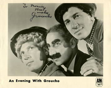
MARX GROUCHO: (1890-1977)International Autograph Auctions Europe S.L.4.5(52)See Sold PriceMar 12, 2024
LISZT FRANZ: (1811-1886)International Autograph Auctions Europe S.L.4.5(52)See Sold PriceMar 13, 2024


![[SEUTTER, M] 52 Maps of Europe sold together (1 of 4)](https://p1.liveauctioneers.com/1124/187577/94368891_1_x.jpg?height=282&quality=70&version=1607095126)