ATLAS of ANTIENT GEOGRAPHY by SAMUEL BUTLER 1843John McInnis Auctioneers,LLC4.5(505)See Sold PriceFeb 24, 2024
18TH C. ANTIQUE MAP: FRENCH & INDIAN WAR, FRAMEDThomaston Place Auction Galleries4.4(393)See Sold PriceFeb 24, 2024
Rand McNally Railroad Map Cabinet w/ 21 Railroad MapsRail & Road Auctions4.6(165)See Sold PriceMar 08, 2024
Keith Haring - Ink on New York Map, Best Buddies, Inscribed, Signed, and DatedSapphire Auction Gallery4(67)See Sold PriceMar 02, 2024
LATE 17TH C. FRENCH MAP OF THE NEW WORLD BY ALEXIS-HUBERT JAILLOT (1632-1712)Thomaston Place Auction Galleries4.4(393)See Sold PriceFeb 24, 2024
Central Railroad of New Jersey Map of Sandy Hook Route-ca. 1903JM Hobby Supply and Railroad Artifact Auctions4.4(127)See Sold PriceFeb 24, 2024
Lot of Six Mixed Atlas Box Cars-HO Scale-New in BoxJM Hobby Supply and Railroad Artifact Auctions4.4(127)See Sold PriceFeb 25, 2024
Rand McNally/Santa Fe Railroad Map of Iowa-1912JM Hobby Supply and Railroad Artifact Auctions4.4(127)See Sold PriceFeb 24, 2024
NICOLAES VISSCHER (NETHERLANDS, 1618-1709) MAP OF THE NEW WORLDThomaston Place Auction Galleries4.4(393)See Sold PriceFeb 24, 2024
17TH C. WORLD MAP BY NICOLAES VISSCHER (NETHERLANDS, 1618-1709)Thomaston Place Auction Galleries4.4(393)See Sold PriceFeb 24, 2024
Lot of Six Mixed Atlas Cabooses-HO Scale-New in BoxJM Hobby Supply and Railroad Artifact Auctions4.4(127)See Sold PriceFeb 25, 2024
SoldTHREE ANTIQUE MAPS, comprising West Riding of YorkshireTHREE ANTIQUE MAPS, comprising West Riding of Yorkshire by Blome, North Riding of Yorkshire by Morden; and Northallerton by Robert Cooper, each framed. (3) Blome 28.5cm by 36cmSee Sold Price
SoldEarly 20th Century English School. "A Map of the NorthEarly 20th Century English School. "A Map of the North Part of West Riding of Yorkshire", Map, 16" x 21", and three further maps of 'Merionith', ''Devonshire', 'Herefordshire', by various hands, fourSee Sold Price
SoldEarly 20th Century English School. "A Map of the NorthEarly 20th Century English School. "A Map of the North Part of West Riding of Yorkshire", Map, 16" x 21", and three further maps of 'Merionith', ''Devonshire', 'Herefordshire', by various hands, fourSee Sold Price
Cary: Antique Map of Part of Yorkshire, 1787Title/Content of Map: 1787 Cary Map of Part of Yorkshire -- Pat of the West Riding of Yorkshire Date Printed: 1787, London Cartographer: J Cary Size: 8.3 x 10.2 in. Condition: Very good. Clear impressSee Sold Price
Cary: Antique Map of Part of Yorkshire, 1787Title/Content of Map: 1787 Cary Map of Part of Yorkshire -- Pat of the West Riding of Yorkshire Date Printed: 1787, London Cartographer: J Cary Size: 8.3 x 10.2 in. A nice map of part of Yorkshire, EnSee Sold Price
Sold1787 Cary Antique Map of Part of YorkshireTitle/Content of Map: 1787 Cary Map of Part of Yorkshire -- Pat of the West Riding of Yorkshire Date Printed: 1787, London Cartographer: J Cary Size: 8.3 x 10.2 in. A nice map of part of Yorkshire, EnSee Sold Price
Cary: Antique Map of Part of Yorkshire, 1787Map: 1787 Cary Map of Part of Yorkshire -- Pat of the West Riding of Yorkshire Cartographer: J Cary Year / Place: 1787, London Map Dimensions: 8.3 x 10.2 in. Condition: Very good. Clear impression witSee Sold Price
SoldRobert Morden (17th-18th Century) British. "The WestRobert Morden (17th-18th Century) British. "The West Riding of Yorkshire", Map, 14.25" x 16.5", and three companion pieces, "Westmoreland", "Lincolnshire" and "The North Riding of Yorkshire" and one fSee Sold Price
Four Framed Antique Prints & A Pair of Small EngravingsFour Framed Antique Prints & A Pair of Small Engravings of Stately Homes in Essex after JP Neale. The Maps of Cumberland by J Ellis, Yorkshire West Riding, Nottinghamshire and Roma Antiqua.See Sold Price
9 Maps from Cary’s New and Correct Atlas 1793Including: Yorkshire North Ridge of Yorkshire East Riding of Yorkshire South part of the West Riding of Yorkshire North part of the West Riding of Yorkshire Suffolk Somersetshire ShropshSee Sold Price
SoldYorkshire.- - A bound group of 8 maps and plans,comprising 2 county maps, North and East Ridings, and West Riding, by Edward Baines, plans of York, Sheffield and Kingston upon Hull, also by Edward Baines, and Leeds by Charles Fowler, also 2 distancSee Sold Price
Three antique maps comprising Somersetshire andThree antique maps comprising Somersetshire and Wiltshire by Robert Morden and Farrington Ward, dated 1755, framed, the largest 44cm x 36.5cmSee Sold Price
SoldThree Continental MapsA Group of Three Antique Continental Maps, comprising: "A New Map of the Kingdom of France...", published by Laurie & Whittle, London, 1794, hand-colored, sight 19 in. x 23 1/2 in., framed; "PrincipatSee Sold Price
Three antique hand coloured maps comprising a map ofThree antique hand coloured maps comprising a map of the Hundred of Middleton alias Milton and of Tenham, Italia Antiqua and Cambridgeshire engraved by John Cary, mounted and glazed, two mounted, theSee Sold Price
SoldAntique Map of the West Riding and AinstyAntique Map of the West Riding and Ainsty. Image Size: 17 x 21.5 in. Overall Size: 19.25 x 24 in. This item is framed behind glass.See Sold Price
3 Maps Yorkshire London 1750Bowen, Emanuel and Kitchin, Thomas "An Accurate Map of the West Riding, Yorkshire…" London, John Hinton, probably from The Large English Atlas of 1755. 530mm x 705mm Together with 2 additional imageSee Sold Price
Three antique hand coloured maps compris...Three antique hand coloured maps comprising a map of the Hundred of Middleton alias Milton and of Tenham, Italia Antiqua and Cambridgeshire engraved by John Cary, mounted and glazed, two mounted, theSee Sold Price
SoldMoule, Thomas C1835 British Map. Yorkshire West RidingSteel Engraved Map Published C1835, London for "A Complete and Universal English Dictionary" by the Rev. James Barclay et al. Maps by Thomas Moule. Paper Size: 11 x 8.5 inch (28 x 22cm) Minor toningSee Sold Price
SoldMoule, Thomas C1840 British Map. Yorkshire West RidingSteel Engraved Map Published C1840, London for "A Complete and Universal English Dictionary" by the Rev. James Barclay et al. Maps by Thomas Moule. Paper Size: 11 x 8.5 inch (28 x 22cm) Good ConditionSee Sold Price
Moule, Thomas C1835 British Map. Yorkshire West RidingSteel Engraved Map Published C1835, London for "A Complete and Universal English Dictionary" by the Rev. James Barclay et al. Maps by Thomas Moule. Paper Size: 11 x 8.5 inch (28 x 22cm) Minor toningSee Sold Price
Moule, Thomas C1835 British Map. Yorkshire West RidingSteel Engraved Map Published C1835, London for "A Complete and Universal English Dictionary" by the Rev. James Barclay et al. Maps by Thomas Moule. Paper Size: 11 x 8.5 inch (28 x 22cm) Minor toningSee Sold Price
SoldBowen (Emanuel) Map of the West RidingBowen (Emanuel) An Accurate Map of the West Riding of York Shire, engraved map of the West Riding of Yorkshire with original outline hand-colouring, pictorial cartouche and vignette view of LeSee Sold Price
Portfolio of 15 County Maps by Robert Morden (English 1650-1703)Nadeau's Auction Gallery4.7(409)See Sold PriceFeb 24, 2024
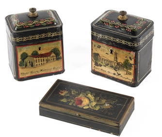
Three Antique Tole Painted Boxes, West Chester, Pennsylvania InterestHoch LTD.4.6(79)See Sold PriceFeb 25, 2024
Arrowsmith & Lewis - Map of PolynesiaTrillium Antique Prints & Rare Books4.5(32)See Sold PriceFeb 24, 2024
Arrowsmith & Lewis - Map of North AmericaTrillium Antique Prints & Rare Books4.5(32)See Sold PriceFeb 24, 2024
Arrowsmith & Lewis - Map of the World on Mercator's ProjectionTrillium Antique Prints & Rare Books4.5(32)See Sold PriceFeb 24, 2024
Arrowsmith & Lewis - Map of LouisianaTrillium Antique Prints & Rare Books4.5(32)See Sold PriceFeb 24, 2024
Arrowsmith & Lewis - Map of the United StatesTrillium Antique Prints & Rare Books4.5(32)See Sold PriceFeb 24, 2024
Carey, pub. 1796 - A Chart of the West IndiesTrillium Antique Prints & Rare Books4.5(32)See Sold PriceFeb 24, 2024
Map: A 19thC engraved map of West Riding, titled A Map of the North Part of the West Riding ofClaydon Auctioneers Ltd4.3(125)See Sold PriceFeb 26, 2024
NORTH WEST AFRICA Maghreb Morocco Tunisia Algeria JOHNSTON 1897 old mapJasper524.5(9.9k)See Sold PriceFeb 28, 2024
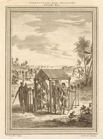
West Africa. Shrines of the Kings of Guinea, from Bry. Heads on stakes 1747Jasper524.5(9.9k)See Sold PriceFeb 28, 2024
Gulf of Guinea. Ghana Togo Benin Nigeria. ADMIRALTY sea chart 1928 (1954) mapJasper524.5(9.9k)See Sold PriceFeb 28, 2024
Cooke, George 1801 Antique Map. West Indies CaribbeanAlbion Auctions4.6(341)See Sold PriceMar 01, 2024
Virginia and West Virginia Topography MapsRapid Estate Liquidators and Auction Gallery4.5(1.1k)See Sold PriceFeb 28, 2024