3 Maps Yorkshire London 1750Bowen, Emanuel and Kitchin, Thomas "An Accurate Map of the West Riding, Yorkshire…" London, John Hinton, probably from The Large English Atlas of 1755. 530mm x 705mm Together with 2 additional imageSee Sold Price
SoldBOWEN, Emanuel c.1750 Yorkshire Map. 'An AccurateBOWEN, Emanuel c.1750 Yorkshire Map. 'An Accurate Map of the West Riding of Yorkshire.' Published c.1750, London, by Bowles & Sayer. With full margins & period outline colour. 58x76cmSee Sold Price
SoldAn Accurate Map of the County of Surrey. c.1750.[England] Bowen, Emanuel. “An Accurate Map of the County of Surrey; Divided into its Hundreds.” London, c.1750. Engraved map. 27 7/8” x 20 3/4”. Framed: 31” x 24”.See Sold Price
SoldGibson Map of the MidwestGIBSON, John (active 1750-1792). [Colonial America]. Midwest.Engraved Map. London: 1763. 8 1/3" x 10" sheet. Relief shown pictorially. Shows the area from Canada to the Gulf of Mexico and the Rocky MoSee Sold Price
SoldCary's Traveller's Companion - England & Wales''Cary's Traveller's Companion, or a Delineation of the Turnpike Roads of England and Wales'', G. & J. Cary Engravers, London, 1828, 42 maps, including a folding map of Yorkshire, 12mo (4 3/4 x 7 1/2'See Sold Price
SoldCary's Traveler's Companion - England & Wales'Cary's Traveler's Companion, or a Delineation of the Turnpike Roads of England and Wales'', G. & J. Cary Engravers, London, 1828, 42 maps, including a folding map of Yorkshire, 12mo (4 3/4 x 7 1/2'')See Sold Price
SoldAaron Arrowsmith (1750-1823), Map of India, 3 Parts,Hand-colored copper engraving on paper England, 1804 Aaron Arrowsmith (1750-1823) - English cartographer, engraver and publisher Typographically inscribed to the margin of one map, ‘London PublishedSee Sold Price
SoldA Topographical Map of the North Part of New YorkWilliam Faden (1750 - 1836). London: Faden, 1793. 19 3/4 x 13 inches. This map records activity in 1776 when the British, led by General Howe, attacked New York City, defended by General Washington. DSee Sold Price
Speed Map of Yorkshire, EnglandSPEED, John (1552-1629). York Shire. Engraved map with original hand color. London, 1610 [1612, Latin Text]. 16 5/8" x 21 3/4" sheet.See Sold Price
SoldSpeed Map of YorkshireSpeed, John (1551-1629). [Yorkshire, England] The North and East Ridings of Yorkshire. Engraved map with original hand color. London: Humble, 1610. 18 5/8" x 21 3/4" sheet.See Sold Price
Sold8 vols. Decorative leather bindings. Inc. Maxwell[Fine bindings] 8 volumes, 6 titles. Group of leather bindings. (1) “A Friendly Letter to a Patient” London, c.1750. (2) 3 vol. “The British Classics” 1803-7. (4) Broughton, RhSee Sold Price
THREE EARLY MAPS. The two largest are hTHREE EARLY MAPS. The two largest are handcolored. Scandinavia, dated 1719. 21" x 25"; Ulster, sold by William Berry in London. 19 3/4" x 23". And a small engraved map of Yorkshire from a magazine. 8"See Sold Price
SoldArrowsmith Map of the United States 1802.ARROWSMITH, Aaron Sr. (1750-1823).A Map of the United States of America.Engraved map on four sheets.London: Arrowsmith, 1796 (1802).24 1/4" x 29 3/4" sheet; 30" x 34 1/4" framed, all four. The first mSee Sold Price
Arrowsmith Map of MexicoA New Map of Mexico and Adjacent Provinces Compiled from Original Documents. Aaron Arrowsmith (1750-1823). Engraved map in four parts. London: Aaron Arrowsmith, 1810. Each approximately: 25 3/8 x 31 1See Sold Price
SoldMoule, Thomas C1850 Lot of 3 British Maps. YorkshireIncl North Riding, West Riding, and East Riding. Steel Engraved Map Published C1850 "A Complete and Universal English Dictionary" by the Rev. James Barclay et al. Maps by Thomas Moule. Paper Size: 10.See Sold Price
Sold4 Maps, Cary, John, Yorkshire, London 1793MAP. Cary, John, four maps of Yorkshire, London 1793, Includes: Part of the West Riding of Yorkshire. * Part of the West Riding of Yorkshire. (different than preceding.) * North Riding of Yorkshire. *See Sold Price
4 Maps, Cary, John, Yorkshire, London 1793MAP. Cary, John, four maps of Yorkshire, London 1793, Includes: Part of the West Riding of Yorkshire. * Part of the West Riding of Yorkshire. (different than preceding.) * North Riding of Yorkshire. *See Sold Price
SoldWyld (James) Map of IndiaWyld (James) Map of India, engraved map in original hand-colouring, folding in sections and mounted on linen, in original cloth slip-case, 1843; and 3 other folding maps, London, Europe and thSee Sold Price
SoldEllis (J) A Modern Map of YorkshireEllis (J) A Modern Map of Yorkshire; The East Riding...; The North Riding..., together 3 small maps of Yorkshire with decorative cartouches, 195 x 245mm., Bowles & Sayer, [1766], and 2 others,See Sold Price
SoldA George II silver dish with flared rim, 3.5insA George II silver dish with flared rim, George Campar, London, 1750, 3.5insSee Sold Price
Sold(3) ANTIQUE MAPS OF TOURS & LONDON ROADS, PAMPHLET(lot of 3) Paper ephemera, including: (1) pamphlet, "A Description of Mr. West's Picture of Death on the Pale Horse; Or, the Opening of the First Five Seals," John Galt (Scottish, 1779-1839), printedSee Sold Price
Sold3 Framed maps: Maryland, Sandwich Isles & London.[Various] (1) “Chart of the Sandwich Isles.” London, extracting from Anderson’s edition of Cook’s Third Voyage. c.1785. 13 7/8" x 8 3/4". Framed: 19 1/2" x 14 1/2". (2) â€See Sold Price
SoldFrance and Its Revolutions 1850France and Its Revolutions: A Pictorial History 1789-2959 by George Long. 1850. Charles Knight. London. 3 foldout maps. Book plate on front inside cover. Raised Bands. 641 pp. 11.25" x 8" x 1.75" withSee Sold Price
DAVID ROBERTS - Holy Land / Syria / Egypt etc. 3 x Folio Volumes 1849 Very RareLuis Porretta Fine Arts4.3(10)See Sold PriceMar 02, 2024
FRANK MARMINGTON c1910 National Gallery Canada Signed Engraving London St. Pauls 20" x 16"Luis Porretta Fine Arts4.3(10)See Sold PriceMar 02, 2024
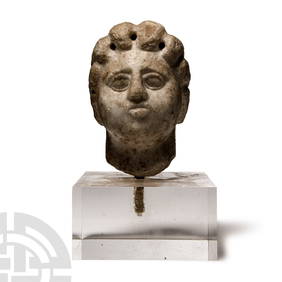
Large Romano-British 'Yorkshire' Jet Gaming DiceTimeLine Auctions Ltd.4.5(183)See Sold PriceMar 05, 2024
Archaeological Books - Streeter - Gold: Legal Regulations for the Standard of Gold & Silver Wares inTimeLine Auctions Ltd.4.5(183)See Sold PriceMar 06, 2024
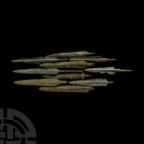
Western Asiatic Bronze Arrowheads, Javelin Heads and DaggersTimeLine Auctions Ltd.4.5(183)See Sold PriceMar 07, 2024
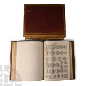
Numismatic Books - Rudding's Coinage of Britain Vol I-III, Plus SuplementTimeLine Auctions Ltd.4.5(183)See Sold PriceMar 09, 2024
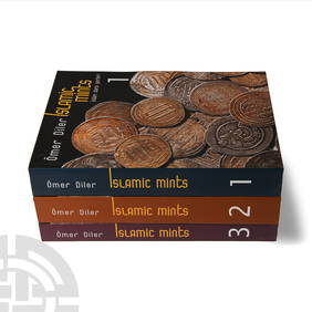
Numismatic Books - Diler - Islamic Mints Volumes 1-3TimeLine Auctions Ltd.4.5(183)See Sold PriceMar 09, 2024
Donovan's The Natural History of British Shells - 5 Volumes in 3 Books with 180 EngravingsTrillium Antique Prints & Rare Books4.5(30)See Sold PriceFeb 24, 2024
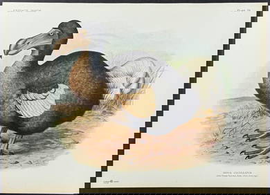
Rothschild, Extinct - Dodo Bird (Didus Cucculatus) with 3 Additional Outline PlatesTrillium Antique Prints & Rare Books4.5(30)See Sold PriceFeb 24, 2024
John Senex Map of Louisiana & Mississippi RiverWillow Auction House4.5(283)See Sold PriceMar 14, 2024