MATTHEWS c1856 Map Of Upper Canada Ontario Indian Land Agency Divisions Scarce!Luis Porretta Fine Arts4.3(10)See Sold PriceMar 02, 2024
DEVINE c1856 Dr Salters Map Of Lake Huron Ontario Indian Lands etc. No. 7 ScarceLuis Porretta Fine Arts4.3(10)See Sold PriceMar 02, 2024
DUNLEVIE c1856 Map Counties Of Gaspe & Bonaventure Quebec Canada SCARCE! #1Luis Porretta Fine Arts4.3(10)See Sold PriceMar 02, 2024
DUNLEVIE c1856 Map Counties Of Gaspe & Bonaventure Quebec Canada SCARCE! #2Luis Porretta Fine Arts4.3(10)See Sold PriceMar 02, 2024
Map UNITED COUNTIES LEEDS & GRENVILLE by Walling 1861 Rare Canada Map 5ft x 5ftLuis Porretta Fine Arts4.3(10)See Sold PriceMar 02, 2024
Ambroise TARDIEU c1822 Map Venice Napoleon Italian Campaign 17" x 11"Luis Porretta Fine Arts4.3(10)See Sold PriceMar 02, 2024
SoldSmith New Map for Travellers through the USANew Map for Travellers through the United States of Ameirca. Calvin J. Smith. Engraving with original color in outline. New York: Sherman and Smith, 1846. 21 x 1/2 x 27 inches sheet, 37 x 36 1/2 incheSee Sold Price
SoldSmith (Charles) Smith's New Map of London and StreSmith (Charles) Smith's New Map of London and Street Indicator,from Islington to Kennington Oval, and from Commercial and Surrey Docks to Hyde Park, with indicator tape on original brass mountSee Sold Price
SoldEngland & Wales.- Smith (Charles) Smith's New Map ofEngland & Wales.- Smith (Charles) Smith's New Map of the Inland Navigation of England & Wales, with details of the inland waterways, or rivers and canals, of England and Wales, engraving with originalSee Sold Price
SoldCary (John) Cary's Six Sheet Map of England and WaCary (John) Cary's Six Sheet Map of England and Wales with Part of Scotland,engraved map, outline colouring, disected onto linen, 1350 x 1080mm, 1818 § Smith's New Map of England and Wales witSee Sold Price
SoldSMITH'S NEW OUTLINE MAP OF THE HUMAN SYSTEM, ANATOMICALSMITH'S NEW OUTLINE MAP OF THE HUMAN SYSTEM, ANATOMICAL REGIONS, NO. 1, published by American Manikin Co., Peoria, Illinois, copyright secured 1888; in original case with eleven tin lithograph attachmSee Sold Price
SoldRare Smith's New Outline Map of The Human SystemRare Smith's New Outline Map of The Human System Anatomical Regions No. 1 & 2 published by American Manikin Co Peoria, IL copyright 1888 - 44 1/2" x 20" closed - 40" openSee Sold Price
Rand McNally: Mobil - Northern New England Map, USAOriginal Rand McNally: Mobil - Northern New England Map, 1965 USA. Approx. 25 x 35.5 inches, 24 - fold. Approx. 5 x 8.5 inches folded. Estimate price: $40 - $50. NO RESERVE auction. Start price is VERSee Sold Price
SoldC. Smith Publ. New Map of Rutland, 1808 17 x19in.C. Smith Publ. unframed coloured engraving New Map of Rutland, 1808 17 x19in.See Sold Price
RAND MCNALLY: MOBIL - NORTHERN NEW ENGLAND MAP, USARAND MCNALLY: MOBIL - NORTHERN NEW ENGLAND MAP, USA, 1965 Approx. 25 x 35.5 inches, 24 - fold. Approx. 5 x 8.5 inches folded. ESTIMATE PRICE: $40 - $50. OFFER: If an item is NOT SOLD, you can still giSee Sold Price
RAND MCNALLY: MOBIL - NORTHERN NEW ENGLAND MAP, USAORIGINAL RAND MCNALLY: MOBIL - NORTHERN NEW ENGLAND MAP, USA, 1965 Approx. 25 x 35.5 inches, 24 - fold. Approx. 5 x 8.5 inches folded. ESTIMATE PRICE: $40 - $50. NO RESERVE auction. Start price is VERSee Sold Price
RAND MCNALLY: MOBIL - NORTHERN NEW ENGLAND MAP, USAORIGINAL RAND MCNALLY: MOBIL - NORTHERN NEW ENGLAND MAP, USA, 1965 Approx. 25 x 35.5 inches, 24 - fold. Approx. 5 x 8.5 inches folded. ESTIMATE PRICE: $40 - $50. OFFER: If an item is NOT SOLD, you canSee Sold Price
"SMITHS NEW OUTLINE MAP HUMAN SYSTEM"SMITHS NEW OUTLINE MAP OF THE HUMAN SYSTEM" 1888 American Manikin Co. Wood and tin litho moveable parts, appears complete. Folds into carrying oak case. 44"x40" open. Estimate $150-$300See Sold Price
SoldSet of 7 Sterling Silver ChargersSet of 7 American sterling silver place plates marked William J. Smith's New York USA, c. 20th c 12.5" Diameter Condition: GoodSee Sold Price
SoldJ Harrison, 'A map of Shropshire', hand colouredJ Harrison, 'A map of Shropshire', hand coloured engraving, published London 1788, 13.5" x 18.5", also C S Smith, 'A new map of Salop', and Robert Morden, 'Devonshire', (3)See Sold Price
SoldCaptain John Smith New England Scroll MapCaptain John Smith scroll map depicting Smith's Portraictuer Of The New England Coast in 1614. Map is printed on paper affixed to linen. Dated 1614.See Sold Price
SoldSmith (Charles) New Post Map of the Northern PartsSmith (Charles) New Post Map of the Northern PartsIncluding the whole of the United Netherlands and Switzerland, showing the post stations, engraved map with original hand-colouring, 1050 x 85See Sold Price
SoldMap of Mexico | Map of Central AmericaTitle/Content of Map: Map of Mexico | Map of Central America Date: 1853 Cartographer: SMITH, ROSWELL C. Size: 10.3Height - 8.75Width Publisher: DANIEL BURGESS & CO. From Smith's New Geography. Two mapSee Sold Price
Smith (Charles) Post Map of France & GermanySmith (Charles) New Post Map of the Northern Parts of France and Germany, Including the whole of the United Netherlands and Switzerland, showing the post stations, engraved map with original hSee Sold Price
SoldLake District.- Smith (Charles) Smith's New and AcLake District.- Smith (Charles) Smith's New and Accurate Map of the Lakes,in the counties of Cumberland, Westmoreland and Lancaster, engraved map with original hand-colouring, 610 x 490mm., diSee Sold Price
SoldSmith (Charles) Map of CumberlandSmith (Charles) A New Map of the County of Cumberland,engraved map with original outline hand-colouring, 495 x 440mm., central horizontal fold, slightly discoloured, 1808 Cary (John) A Map oSee Sold Price
SoldSmith (C) Map of the County of CumberlandSmith (Charles) A New Map of the County of Cumberland,engraved map with original outline hand-colouring, 495 x 440mm., central horizontal fold, slightly discoloured, 1808 Cary (John) A Map oSee Sold Price
Rand McNally: Mobil - Northern New England Map, 1965For your consideration here is the Original Rand McNally: Mobil - Northern New England Map, 1965 USA. Approx. 25 x 35.5 inches, 24 - fold. Approx. 5 x 8.5 inches folded. For your convenience we will sSee Sold Price
Rand McNally: Mobil - Northern New England Map, 1965For your consideration here is the Original Rand McNally: Mobil - Northern New England Map, 1965 USA. Approx. 25 x 35.5 inches, 24 - fold. Approx. 5 x 8.5 inches folded. For your convenience we will sSee Sold Price
American Express/New York Central Railroad Map of the United States-1934JM Hobby Supply and Railroad Artifact Auctions4.4(127)See Sold PriceFeb 24, 2024
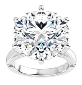
10.08 ct. Hearts & Arrows Round Natural Diamond Solitaire Ring 18k White GoldReserve Stock Jewelers & Auctions4.1(10)See Sold PriceMar 03, 2024
GIA 3.50 ct. Natural Round Diamond Solitaire Ring In 14k White GoldReserve Stock Jewelers & Auctions4.1(10)See Sold PriceMar 03, 2024
Portfolio of 15 County Maps by Robert Morden (English 1650-1703)Nadeau's Auction Gallery4.7(410)See Sold PriceFeb 24, 2024
1849 THE NEW-ENGLAND MERCANTILE UNIONNorth American Artifact Auctions4.7(201)See Sold PriceApr 20, 2024
Mort Kunstler Civil War Print - An Apple for Traveller Custom Gallery FramedBidhaus4.3(773)See Sold PriceFeb 23, 2024
Maitland Smith Tessellated Stone & Brass Apple BoxHill Auction Gallery 4.7(1k)See Sold PriceFeb 28, 2024
Map: A 19thC engraved and hand coloured map of Buckingham titled A New Map of BuckinghamshireClaydon Auctioneers Ltd4.3(125)See Sold PriceFeb 26, 2024
1953 Street And Smiths New York Yankees Mickey Mantle Baseball Pictorial YearbookWeatherham Estate Treasures3.9(159)See Sold PriceMar 21, 2024
Herman Moll A New Map of Ye North Parts of AmericaWillow Auction House4.5(292)See Sold PriceMar 14, 2024
Lisette Model, Willie 'The Lion' Smith, New YorkLos Angeles Modern Auctions4.4(24)See Sold PriceMar 08, 2024
FRAMED Autographed BILLY SMITH New York Islanders Jersey JSA COAMynt Auctions4.6(711)See Sold PriceMar 21, 2025