Chaim Soutine (Belarusian/French, 1893-1943) - La Petite Fille dans la VerdureFreeman's | Hindman4.5(158)See Sold PriceFeb 27, 2024
Elisabeth Frink (British, 1930-1993) - Harbinger Bird IFreeman's | Hindman4.5(158)See Sold PriceFeb 27, 2024
AMERICAN SEASCAPE PAINTING BY ROSS EMBROSE MOFFETTAntique Arena Inc.4.5(852)See Sold PriceMar 02, 2024
CHARLES HENRY GIFFORD (Massachusetts, 1839-1904), Luminist view of three sailboats in a quietEldred's4.7(409)See Sold PriceFeb 28, 2024
RARE MANHATTAN PROJECT GLASS LEADED FROM THE MANHATTAN PROJECT WORLD WAR II WW2 724 GRAMSCol. Christie Hatman Auctioneers4.5(312)See Sold PriceFeb 26, 2024
Estate Fresh Civil War Cavalry C. Roby 1863 With ScabbardRalph Fontaine Heritage Auctions Inc.4.7(235)See Sold PriceFeb 25, 2024
ABSTRACT ARAB LEBANESE OIL PAINTING BY ETEL ADNANAntique Arena Inc.4.5(852)See Sold PriceMar 02, 2024
Rand McNally: Mobil - Northern New England Map, USAOriginal Rand McNally: Mobil - Northern New England Map, 1965 USA. Approx. 25 x 35.5 inches, 24 - fold. Approx. 5 x 8.5 inches folded. Estimate price: $40 - $50. NO RESERVE auction. Start price is VERSee Sold Price
RAND MCNALLY: MOBIL - NORTHERN NEW ENGLAND MAP, USARAND MCNALLY: MOBIL - NORTHERN NEW ENGLAND MAP, USA, 1965 Approx. 25 x 35.5 inches, 24 - fold. Approx. 5 x 8.5 inches folded. ESTIMATE PRICE: $40 - $50. OFFER: If an item is NOT SOLD, you can still giSee Sold Price
RAND MCNALLY: MOBIL - NORTHERN NEW ENGLAND MAP, USAORIGINAL RAND MCNALLY: MOBIL - NORTHERN NEW ENGLAND MAP, USA, 1965 Approx. 25 x 35.5 inches, 24 - fold. Approx. 5 x 8.5 inches folded. ESTIMATE PRICE: $40 - $50. NO RESERVE auction. Start price is VERSee Sold Price
RAND MCNALLY: MOBIL - NORTHERN NEW ENGLAND MAP, USAORIGINAL RAND MCNALLY: MOBIL - NORTHERN NEW ENGLAND MAP, USA, 1965 Approx. 25 x 35.5 inches, 24 - fold. Approx. 5 x 8.5 inches folded. ESTIMATE PRICE: $40 - $50. OFFER: If an item is NOT SOLD, you canSee Sold Price
RAND MCNALLY: MOBIL - NORTHERN NEW ENGLAND MAP, USAORIGINAL RAND MCNALLY: MOBIL - NORTHERN NEW ENGLAND MAP, USA, 1965 Approx. 25 x 35.5 inches, 24 - fold. Approx. 5 x 8.5 inches folded. ESTIMATE PRICE: $40 - $50. If an item is NOT SOLD, you can stillSee Sold Price
RAND MCNALLY: MOBIL - NORTHERN NEW ENGLAND MAP, USAORIGINAL Rand McNally: Mobil - Northern New England Map, 1965 USA Approx. 25 x 35.5 inches, 24 - fold. Approx. 5 x 8.5 inches folded. ESTIMATE PRICE: $40 - $50. NO RESERVE auction. Start price is VERYSee Sold Price
Rand McNally: Mobil - Northern New England Map, USAOriginal Rand McNally: Mobil - Northern New England Map, 1965 USA. Approx. 25 x 35.5 inches, 24 - fold. Approx. 5 x 8.5 inches folded. ESTIMATE PRICE: $40 - $50. NO RESERVE auction. Start price is VERSee Sold Price
Rand McNally: Mobil - Northern New England Map, USAOriginal Rand McNally: Mobil - Northern New England Map, 1965 USA. Approx. 25 x 35.5 inches, 24 - fold. Approx. 5 x 8.5 inches folded. For your convenience we will ship your item for a reasonable pricSee Sold Price
RAND MCNALLY: MOBIL - NORTHERN NEW ENGLAND MAP, USAORIGINAL RAND MCNALLY: MOBIL - NORTHERN NEW ENGLAND MAP, USA, 1965 Approx. 25 x 35.5 inches, 24 - fold. Approx. 5 x 8.5 inches folded. ESTIMATE PRICE: $40 - $50. NO RESERVE auction. Start price is VERSee Sold Price
Rand McNally: Mobil - Northern New England Map, 1965For your consideration here is the Original Rand McNally: Mobil - Northern New England Map, 1965 USA. Approx. 25 x 35.5 inches, 24 - fold. Approx. 5 x 8.5 inches folded. For your convenience we will sSee Sold Price
Rand McNally: Mobil - Northern New England Map, 1965For your consideration here is the Original Rand McNally: Mobil - Northern New England Map, 1965 USA. Approx. 25 x 35.5 inches, 24 - fold. Approx. 5 x 8.5 inches folded. For your convenience we will sSee Sold Price
SoldRand McNally: Mobil - Northern New England Map, 1965Mobil - Northern New England 1965, Rand McNally Approx. 25x35.5 inches, 24-fold. Approx. 5x8.5 inches folded. No Reserve: This lot starts at $1 and has no reserve as a courtesy so that collectors canSee Sold Price
SoldRand McNally 1900s Era New England Railroad MapParchment map of railroad system for Boston and Maine, New York New Haven and Maine Central Railroads. Shows all lines, major towns and borders. 45" wide x 60"See Sold Price
Sold4pc New England ANTIQUE ENGRAVED MAPS 1886-1891Details: This lot consists of the antique lithographed maps shown in the corresponding image(s).This lot consists of a group of four maps of New England. Three are from Rand, McNally: "New Hampshire"See Sold Price
Sold[America, Maps] 3 city maps, about 1910SCARCE EDITIONS OF EARLY 1900 OF THREE HANDY MAPS OF USA CITIES (NEW YORK, PHILADELPHIA AND NEW ORLEANS) [1.]: Rand, McNally Co.. New handy map of New York City with a large scale map of the borough oSee Sold Price
SoldRand, Mcnally. Commercial Map of USARand, Mcnally & Co., publisher New Commercial Map of the United States and Canada,hand-coloured lithograph map in 2 parts, linen-backed, each 1000 x 680mm., original cloth slip-case, ChicaSee Sold Price
SoldRand, McNally & Co’s Pocket Map New MexicoRand, McNally & Co’s Pocket Map Sippers’ Guide New Mexico, Entire Railroad System Chicago, USA Provenance: Descended in the Preston family of Montgomery Co. VA. to Gen. G.C Wharton, CSA to the preSee Sold Price
Map of Southern [and Northern] Ohio. New Sectional andTitle/Content of Map: Map of Southern [and Northern] Ohio. New Sectional and Township Map of Ohio. Cartographer: RAND, MCNALLY & CO. Date: 1883 Publisher: H.H. HARDESTY & CO. Size: 12.75Height - 19.6WSee Sold Price
Map of Southern [and Northern] Ohio. New Sectional andPublication Date: 1883 Title: Map of Southern [and Northern] Ohio. New Sectional and Township Map of Ohio. Cartographer: RAND, MCNALLY & CO. Publisher: H.H. HARDESTY & CO. Height: 12.75 Width: 19.6 15See Sold Price
Rand, McNally & Co.'S New Business Atlas Map of Michigan. [Northern Peninsula]Publication Date: 1911 Title: Rand, McNally & Co.'S New Business Atlas Map of Michigan. [Northern Peninsula] Cartographer: RAND, MCNALLY & CO. Publisher: RAND, MCNALLY & CO. Height: 18.3 Width: 25.75See Sold Price
Rand, McNally Atlas Map of Michigan, Great LakesTitle/Content of Map: Rand, McNally & Co.'s New Business Atlas Map of Michigan. [Northern Peninsula] Date Printed: 1911 Cartographer: RAND, MCNALLY & CO. Size (inches): 18.3X25.75 Margins stained.PageSee Sold Price
1886 - Northern Italy Map1886 - Northern Italy Map **|**|** This is a beautiful, 129 year old map of Northern Italy - published in the USA by Rand McNally. The map is on much thicker paper than most maps of the same era - itSee Sold Price
Rand, McNally & Co: Map of Northern Michigan, 1898Map: Northern Michigan Maker: Rand, McNally & Co. Date: 1898 New Standard Atlas of the World Size: 28 x 21.5 inches Please note that this lot has a confidential reserve. When you leave a bid in advancSee Sold Price
SoldRand-McNally Map of Brooklyn & Vicinity (118297)22" X 28" in plastic poster frame. Provenance: Country (if not USA): State: New York City/County: Brooklyn Date: 1898See Sold Price
Rand McNally County/Township/Railroad Map of Kansas-1911JM Hobby Supply and Railroad Artifact Auctions4.4(126)See Sold PriceFeb 24, 2024
Rand McNally Railroad Map of Arizona-1909JM Hobby Supply and Railroad Artifact Auctions4.4(126)See Sold PriceFeb 24, 2024
Rand McNally Railroad Map of Colorado-1929JM Hobby Supply and Railroad Artifact Auctions4.4(126)See Sold PriceFeb 24, 2024
Rand McNally Railroad Map of Washington-1906JM Hobby Supply and Railroad Artifact Auctions4.4(126)See Sold PriceFeb 24, 2024
Rand McNally Township County and Railroad Map of Illinois-1879JM Hobby Supply and Railroad Artifact Auctions4.4(126)See Sold PriceFeb 24, 2024
Rand McNally Township County and Railroad Map of Indiana-1880JM Hobby Supply and Railroad Artifact Auctions4.4(126)See Sold PriceFeb 24, 2024
Rand McNally/Santa Fe Railroad Map of Iowa-1912JM Hobby Supply and Railroad Artifact Auctions4.4(126)See Sold PriceFeb 24, 2024
A La Photo Views of the New York Central RR book by Rand McNally-1870sJM Hobby Supply and Railroad Artifact Auctions4.4(126)See Sold PriceFeb 24, 2024
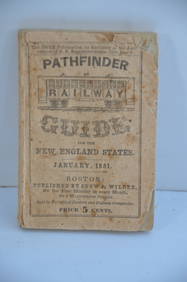
Pathfinder Railway Guide for the New England States-January 1851JM Hobby Supply and Railroad Artifact Auctions4.4(126)See Sold PriceFeb 24, 2024
Pair of Early Railroad Maps - 1874 Delaware, Lackawanna & Western and 1876 Pennsylvania RailroadRail & Road Auctions4.6(165)See Sold PriceMar 07, 2024
Rand McNally Railroad Map Cabinet w/ 21 Railroad MapsRail & Road Auctions4.6(165)See Sold PriceMar 08, 2024
Rand McNally & Co's New Ideal State and County Survey and Atlas 1911North American Artifact Auctions4.6(182)See Sold PriceApr 20, 2024
1849 THE NEW-ENGLAND MERCANTILE UNIONNorth American Artifact Auctions4.6(182)See Sold PriceApr 20, 2024
[MAP]. [ALBRIZZI, Giambatista, 1698-1777]. Carta Geografica...Potter & Potter Auctions4.6(539)See Sold PriceMar 07, 2024
1803 NARRATIVE OF INDIAN WARS IN NEW-ENGLAND antique Stockbridge AMERICANAJasper524.5(9.8k)See Sold PriceFeb 27, 2024
Framed Space Age Rand McNally Map of Planets Poster, 1958PUBLIC SALE4.7(217)See Sold PriceMar 02, 2024
Two Hand-Colored 19th Century Maps of New Orleans and Louisiana, Larger- H.- 12 1/2 in., W.- 15 1/2Crescent City Auction Gallery4.3(229)See Sold PriceMar 08, 2024
New Concise Dictionary Thesaurus Hardcover Book Set 1986Rapid Estate Liquidators and Auction Gallery4.5(1.1k)See Sold PriceMar 03, 2024


![[Tintype] Massive Bowie knife (1 of 1)](https://p1.liveauctioneers.com/7226/317626/170485482_1_x.jpg?height=282&quality=70&version=1706368022)
![[Ambrotype] Magnificent Portrait (1 of 1)](https://p1.liveauctioneers.com/7226/317626/170485477_1_x.jpg?height=282&quality=70&version=1706368022)


![[Tintype] Native American Man w/ Knife (1 of 2)](https://p1.liveauctioneers.com/7226/317626/170485453_1_x.jpg?height=282&quality=70&version=1706368022)
![[REES, Charles] Enlistedman w/ Bowie Knife (1 of 1)](https://p1.liveauctioneers.com/7226/317626/170485489_1_x.jpg?height=282&quality=70&version=1706368022)
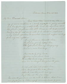
![[Ambrotype] Wounded at Gettysburg (1 of 1)](https://p1.liveauctioneers.com/7226/317626/170485471_1_x.jpg?height=282&quality=70&version=1706368022)


![[Ambrotype] Young Soldier w/ Bowie Knife (1 of 1)](https://p1.liveauctioneers.com/7226/317626/170485459_1_x.jpg?height=282&quality=70&version=1706368022)

![[Daguerreotype] Soldier w/ Bowie Knife (1 of 2)](https://p1.liveauctioneers.com/7226/317626/170485458_1_x.jpg?height=282&quality=70&version=1706368022)
![[Tintype] Soldier w/ Flowers (1 of 1)](https://p1.liveauctioneers.com/7226/317626/170485495_1_x.jpg?height=282&quality=70&version=1706368022)
![[Tintype] Identified North Carolina Infantryman (1 of 2)](https://p1.liveauctioneers.com/7226/317626/170485474_1_x.jpg?height=282&quality=70&version=1706368022)


![[America, Maps] 3 city maps, about 1910 (1 of 10)](https://p1.liveauctioneers.com/2198/56199/31005028_1_x.jpg?height=282&quality=70&version=1415833748)


![Map of Southern [and Northern] Ohio. New Sectional and (1 of 2)](https://p1.liveauctioneers.com/5584/169916/85621272_1_x.jpg?height=282&quality=70&version=1591137604)
![Map of Southern [and Northern] Ohio. New Sectional and (1 of 2)](https://p1.liveauctioneers.com/5584/195879/98794819_1_x.jpg?height=282&quality=70&version=1614724478)
![Rand, McNally & Co.'S New Business Atlas Map of Michigan. [Northern Peninsula] (1 of 3)](https://p1.liveauctioneers.com/5584/289753/153469158_1_x.jpg?height=282&quality=70&version=1684878062)


![[MAP]. [ALBRIZZI, Giambatista, 1698-1777]. Carta Geografica... (1 of 1)](https://p1.liveauctioneers.com/928/318880/171361280_1_x.jpg?height=282&quality=70&version=1707501302)