SoldSmith (Charles) New Post Map of the Northern PartsSmith (Charles) New Post Map of the Northern PartsIncluding the whole of the United Netherlands and Switzerland, showing the post stations, engraved map with original hand-colouring, 1050 x 85See Sold Price
SoldJOHN SMITH'S MAP OF NEW ENGLAND"NEW ENGLAND The most remarqueable parts thus named by the high and might Prince CHARLES, Prince of Great Britaine", colored engraving, made by John Smith, engraved by Simon Passaeus, and printed by JSee Sold Price
Sold1580 Regni Hispaniae Post Omnium EditionesThis original authentic antique map by Ortelius shows the Iberian Peninsula with the Balearic Islands and parts of northern Africa. Spain is well described, with towns and cities, mountain ranges andSee Sold Price
SoldSMITH, JOHN. New England the most remarqueableSMITH, JOHN. New England the most remarqueable parts thus named by the high and mighty Prince Charles, Prince of great Britaine. Engraved folding map, 300x345, ample margins; very minor separations alSee Sold Price
SoldSmith (Charles) Smith's New Map of London and StreSmith (Charles) Smith's New Map of London and Street Indicator,from Islington to Kennington Oval, and from Commercial and Surrey Docks to Hyde Park, with indicator tape on original brass mountSee Sold Price
SoldEngland & Wales.- Smith (Charles) Smith's New Map ofEngland & Wales.- Smith (Charles) Smith's New Map of the Inland Navigation of England & Wales, with details of the inland waterways, or rivers and canals, of England and Wales, engraving with originalSee Sold Price
SoldBONNE'S 1790 MAP OF NEW MEXICO & NEW SPAIN122. 1790 MAP OF NEW MEXICO AND NEW SPAIN French map of northern New Mexico, parts of Spanish Florida and Louisiana and California. Entitled "New Mexico, with the Northerly Part of the Former, or NewSee Sold Price
SoldAntique Britannica War/Battle Map of New York, 1903Title/Content of Map: 'New York, Northern and Eastern part' The sites of important battles and their dates are marked on this map for the following conflicts: War of 1812, American Revolutionary War (See Sold Price
SoldCary (John) Cary's Six Sheet Map of England and WaCary (John) Cary's Six Sheet Map of England and Wales with Part of Scotland,engraved map, outline colouring, disected onto linen, 1350 x 1080mm, 1818 § Smith's New Map of England and Wales witSee Sold Price
SoldGillet “Map Of Northern Part Of New England”published 1823, uncolored as issued, depicting from the northern boundary of Massachusetts to show Maine, Vermont and New Hampshire, with detail of roads and settlements. Yale College is used as the PSee Sold Price
Map of New York City (Northern Part) | New York CityTitle: Map of New York City (Northern Part) | New York City (Southern Part) Publication Date: 1893 Cartographer: CRAM, GEORGE F. Publisher: JOHN F. WAITE Dimensions: 12.5 X 8.8 Additional Information:See Sold Price
SoldA New Map of Ancient Thrace as also the Northern PA New Map of Ancient Thrace as also the Northern Parts of Old Greece - 16 1/2" x 21 1/2"See Sold Price
Smith (Charles) New English AtlasSmith (Charles) New English Atlas, engraved title, 25 engraved maps (of 42), including general map of England and Wales, and Yorkshire on 4 sheets, with original hand-colouring, the majority dSee Sold Price
SoldNew York City (Southern Part). | Map of New York CityTitle: New York City (Southern Part). | Map of New York City (Northern Part). Publication Date: 1892 ca. Cartographer: FISK & CO. Publisher: HUNT & EATON Size: 11x8.6 The People's Cyclopedia map. PleaSee Sold Price
SoldWells (Edward) A New Map of Antient Thrace ...Wells (Edward) A New Map of Antient Thrace ...,also showing the northern part of Old Greece, engraved map, by Sutton Nicholls, with hand-colouring, 370 x 475mm., central vertical fold, minor sSee Sold Price
Sutton Nicholls: A New Map of Ancient Thrace, 1704Map: A New Map of Ancient Thrace Maker: Sutton Nicholls Publisher: Wells, Oxford Date: 1704 Size: Folio - 14.1 inches high x 18.8 inches wide "...as also of the northern parts of Old Greece, viz. MaceSee Sold Price
SoldAtlases.- Smith (Charles) - New English Atlas,engraved title, contents f. and 43 maps (hand-coloured in outline), including a large folding map of Yorkshire, occasional spotting or marking, but generally clean, contemporary half calf, gilt, 1841See Sold Price
SoldAN ANTIQUE MAP, "Johnson's New Map of the State ofAN ANTIQUE MAP, "Johnson's New Map of the State of Texas by Johnson and Ward," hand color and ink on paper, with three small maps of, "Plan of Sabine Lake," "Plan of the Northern Part of Texas," and "See Sold Price
SoldWells (E) A New Map of Denmark, Norway,Wells (Edward) A New Map of Denmark, Norway, Sweden, & Moscovy,with A New Map of Ancient Scandinavia together with as much more of ye Northern Part of Ancient Europe, as Answers to Present DenSee Sold Price
SoldSmith (Charles) - New General Atlas,engraved title, complete according to the Contents list of 56, with table of mountains and rivers, 9 double- and 38 single-page engraved maps with original hand-colouring, the world on Mercator's projSee Sold Price
Sold2 antique maps, New Jersey, revolutionary war map, "A2 antique maps, New Jersey, revolutionary war map, "A plan of the Northern part of New Jersey, showing the positions of the American & British Armies After crossing the North River (Hudson River) in 1See Sold Price
SoldAMOS LAY (AMERICAN, 1765-1851) FOLDING MAP OF NEW YORKAMOS LAY (AMERICAN, 1765-1851) FOLDING MAP OF NEW YORK STATE, hand-colored, titled "Map / OF THE / NORTHERN PART / of the / State / of / NEW YORK / Compiled from actual Survey / By Amos Lay 1812", divSee Sold Price
SoldUK - Staffordshire 1808 Hand Col Map by Charles Smith"A New Map of the County of Stafford" Copper Engraved Map Published 1808, London. Printed for C. Smith. Dissected and linen backed. Original hand colour. Paper Size: 20.5 x 19 inch (52 x 48cm) Good coSee Sold Price
SoldAtlases.- Smith (Charles) Smith's New General Atlas, 45Atlases.- Smith (Charles) Smith's New General Atlas, engraved calligraphic title, 45 hand-coloured engraved maps, 2 double-page of Germany (numbered 19/20 & 21/22), occasional spotting, light marginalSee Sold Price
Michigan Southern and Northern Indiana RR 14th Annual Report-February 28, 1869JM Hobby Supply and Railroad Artifact Auctions4.4(126)See Sold PriceFeb 24, 2024
1849 THE NEW-ENGLAND MERCANTILE UNIONNorth American Artifact Auctions4.6(182)See Sold PriceApr 20, 2024
[ARCTIC]. BOWEN, Emanuel. A New & Accurate Map of the North...Potter & Potter Auctions4.6(539)See Sold PriceMar 07, 2024
Mayo Smith Signed Autographed Vintage Scrapbook Page Cut Yankees JSA II35141Mynt Auctions4.6(680)See Sold PriceFeb 26, 2024
Billy Smith Autographed New York Islanders Signed Mini Goalie Mask JSA COAMynt Auctions4.6(680)See Sold PriceFeb 27, 2024
Postwar American Flyer S Gauge truck assemblies partsElliott Auctions4.5(127)See Sold PriceFeb 24, 2024
1816 MAP NORTHERN PART OF RUSSIA or MUSCOVY in EUROPE copper engraving ANTIQUEJasper524.5(9.8k)See Sold PriceFeb 27, 2024
1803 NARRATIVE OF INDIAN WARS IN NEW-ENGLAND antique Stockbridge AMERICANAJasper524.5(9.8k)See Sold PriceFeb 27, 2024
Dallas Smith Autographed New York Rangers Hockey Puck Beckett 181040Mynt Auctions4.6(680)See Sold PriceMar 01, 2024
Afrique Pays… sud du Lac Tchad 30 Central African Republic VANDERMAELEN 1827 mapJasper524.5(9.8k)See Sold PriceFeb 28, 2024
Black and white map of part of New York City (mostly Manhattan)Proverde Auctions4.3(3)See Sold PriceFeb 28, 2024
Herman Moll A New Map of Ye North Parts of AmericaWillow Auction House4.5(283)See Sold PriceMar 14, 2024
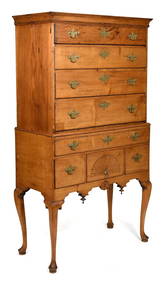
Dr. Charles Smith (American/Louisiana, b. 1940)Neal Auction Company4.6(348)See Sold PriceMar 14, 2024
Andy Warhol (1928-1987): General Custer (from Cowboys and Indians)Abell Auction4.7(632)See Sold PriceMar 09, 2024
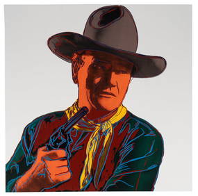
Andy Warhol (1928 - 1987): John Wayne (from Cowboys and Indians)Abell Auction4.7(632)See Sold PriceMar 09, 2024
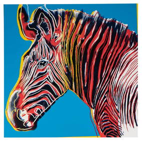
Andy Warhol (1928 - 1987): Grevy's Zebra (from Endangered Species)Abell Auction4.7(632)See Sold PriceMar 09, 2024


![[ARCTIC]. BOWEN, Emanuel. A New & Accurate Map of the North... (1 of 1)](https://p1.liveauctioneers.com/928/318880/171360917_1_x.jpg?height=282&quality=70&version=1707501302)